

Xiang Wang
MOE Key Laboratory for Urban Transportation Complex Systems Theory and Technology, Beijing Jiaotong University, Beijing 100044, China
Yan Xuedong
MOE Key Laboratory for Urban Transportation Complex Systems Theory and Technology, Beijing Jiaotong University, Beijing 100044, China
Wang Jiangfeng
MOE Key Laboratory for Urban Transportation Complex Systems Theory and Technology, Beijing Jiaotong University, Beijing 100044, China
Liu Dan
MOE Key Laboratory for Urban Transportation Complex Systems Theory and Technology, Beijing Jiaotong University, Beijing 100044, China
Information Technology Journal
Year: 2012 | Volume: 11 | Issue: 4 | Page No.: 466-470





ABSTRACT
Focusing on the research on driving simulator road scene, this paper systematically introduces tile library concept applied in the Beijing Jiaotong University Driving Simulator (BJTUDS). It summarizes the tile library creation principle and describes the flexible characteristic of tiles according to the categories of intersections and segments. Furthermore, choosing SketchUp and 3Dmax as modeling tools, the road scene modeling method of BJTUDS is illustrated from aspects of terrain, road, material and environment. The paper finally concludes urban road network modeling process.
PDF Abstract XML References Citation
Article History
Received: October 28, 2011;
Accepted: November 02, 2011;
Published: January 20, 2012
How to cite this article
Xiang Wang, Yan Xuedong, Wang Jiangfeng and Liu Dan, 2012. Road Scene Modeling for Driving Simulator Based on Tile Library Concept. Information Technology Journal, 11: 466-470.
DOI: 10.3923/itj.2012.466.470
URL: https://scialert.net/abstract/?doi=itj.2012.466.470
DOI: 10.3923/itj.2012.466.470
URL: https://scialert.net/abstract/?doi=itj.2012.466.470
INTRODUCTION
Driving simulator is an experiment tool to simulate traffic system in virtual traffic environment, which can achieve the realistic feeling of driving a real vehicle. Driving simulator is safe, economical, efficient, controllable and effortless to collect experiment data. So, it turns into important equipment for traffic safety studies (Nilsson, 1993). Driving simulator can also be applied to the research fields of traffic engineering (Knodler et al., 2005), landscape (Antonson et al., 2009), disease and recovery (Vaux et al., 2010) and vehicle engineering (Reymond et al., 2001). These driving simulator applications are typical experimental studies based on virtual reality.
An important aspect of virtual reality for transportation systems is the road scene model which could impact the experiment fidelity because it directly gives drivers a visual impression that is related to driving behavior and psychology. Therefore, the driving simulator researchers pay much attention to the road scene modeling methods, which can be not only more convenient for the modeling process but also more realistic for the modeling result. Currently, there are two methods to define road scene (Suresh and Mourant, 2005). One is using script to programmatically create the scene at a low level and the other is using commercial simulator’s friendly user interfaces at a high level. Due to the user friendliness required, the high level interfaces have been programmed by academic research facilities and script language was regarded as assistance. On the high level, tile library is the guarantee of friendliness, addressing qualitative issues within self-contained tile databases that allow generating a large variety of environments in a timely and cost-effective manner (Allen and Bruse, 2001). The tile library has been used into traffic safety research widely (Kawamura et al., 2004; Guo et al., 2009).
Therefore, tile library concept is adopted to create road scene in the Beijing Jiaotong University Driving Simulator (BJTUDS). The method of creating road scene to connect the selected tiles from tile library that consists of diverse tile types (intersection tiles, segment tiles, terrain tiles). However, because the road characteristics, traffic design standards and management rules are different among different countries, many foreign road tiles do not adapt to Chinese road scene. It leads to requirement of creating the Chinese road tile library. The fundamental objective of this research is to describe tile library concept, Chinese road tile library creation process and application mechanism.
TILE LIBRARY CREATION AND APPLICATION
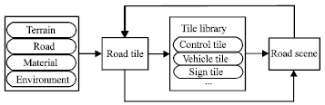
The tile library introduction: Tiles are discrete databases consisting of visual and correlated virtual databases (Papelis, 1998). Tile library is the container of tiles. They include road tiles, vehicle control tiles, signal control tiles and so on. A road tile is an independent aggregate with specific road characteristics. It is a foundational unit in creating road scene model using tile library. Figure 1 depicts the road tile and tile library generation and application mechanism.
 | |
| Fig. 1: | The road tile and tile library generation and application mechanism |
 | |
| Fig. 2: | The steps required in transferring and implementing the road tiles into the BJTUDS |
| Table 1: | The classification of intersection tiles in detail |
 | |
| Table 2: | The classification of segment tiles in detail |
 | |
Terrain, road, material and environment are contained in a road tile which could independently present expected road characteristic. The tiles can be geo-specific, meaning the objects in the graphical database represent actual real-world objects as closely as possible, with a degree of spatial and functional precision deemed sufficient by the user. Road tiles, the elements of tile library, are connected to set up road scene. For a typical Chinese road scene, tiles should be newly built. Tiles are constructed as self-contained and complete databases. They are within the context as reusable, repeatable and associative library elements that provide the researchers capabilities to generate a complex road network. For example, a simple road scene could be created by choosing an intersection tile and four segment tiles in the tile library, but a complex road scene could be set up with multiple intersections, curves, segments and structures and so on. No matter how complicated a scene is, it could also be accomplished by connecting tiles.
Tile library creation: The tile library is expandable as long as construction constraints are followed to ensure compatibility with existing tiles. Tile compatibility is ensured through developmental constraints, including unitized dimensions, the definition of a common local origin and orientation and considerations for tile edge blending (Evans and Sutherland, 1997.). Tiles connect to each other using road and terrain profile definitions, ensuring surface continuity across different tile types. To guarantee that every tile profile could be connected together as expected, tile size has to be appropriate. In general, tiles are square and have the same size. But if one tile is different, the connector between tiles should be the same size.
The core work for constructing tile library is to replenish and consummate tiles to the extent that tiles are complete for the tile requirement of any road scene expected. Tiles can be created through modifying the existing tiles, integrating the existing tiles, or creating from 3-D modeling tools. Tiles could be changeable materials in the BJTUDS software. Many tiles could also be integrated to a new tile.
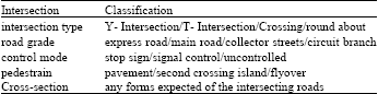
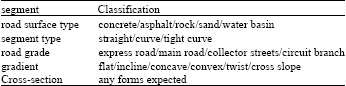
In order to be convenient for the user, the number of tiles that the experiment road scene requests should be reduced as much as possible without any influence on the tile library function. So, the reasonable classification of tiles is requested. Road tiles are divided into intersection tiles and segment tiles as a whole. In detail, Table 1 lists the intersection tiles classification and Table 2 lists the segment tiles classification.
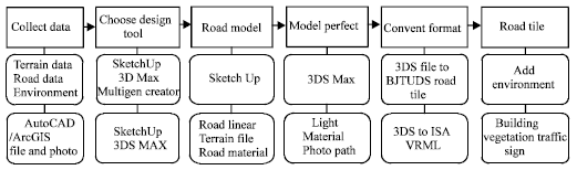
For a whole tile library, all types of intersections and segments in the above tables should be contained. For the tile creation from drawing, there exist many 3D software modeling packages. The three most common real-time packages are SketchUp, Multigen-Paradigm’s Creator and Discreet’s 3D Studio Max. This paper chooses SketchUp and Discreet’s 3D Studio Max software to perform the modeling process and procedure of setting up new road tiles. Creating three-dimensional road tiles for real-time simulation purposes, more specifically for traffic engineering simulation purposes, can be viewed both as an art form and a methodology. Therefore, there exists a general procedure that guides a modeler from the original concept to a final graphical representation. Furthermore, the discussion includes the steps required in transferring and implementing the road tiles into the BJTUDS (Fig. 2).
The first step required in creating a road tile such as an intersection is to obtain data about terrain and intersecting road.
 | |
| Fig. 3: | The cooperation model between AutoCAD and SketchUp |
 | |
| Fig. 4: | The cooperation model between ArcGIS and SketchUp |
 | |
| Fig. 5: | Choose grid to generate terrain model |
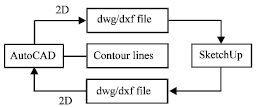
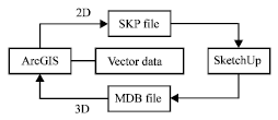
SketchUp and 3DS max are chosen as design tools to create the terrain and road model. For SketchUp, in general, an AutoCAD file or ArcGIS file that could be imported to create terrain model in SketchUp software directly. But the cooperation mode with AutoCAD is different from ArcGIS (Fig. 3, 4).
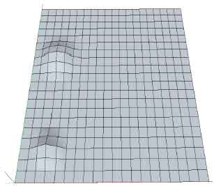
Another popular method of generating terrain is from grid. The grids are all square and the scope of all grids should bigger than the road. For the balance between the computer system Random-Access Memory (RAM) and model precision, one grid size should be set according to the modeling road length. The longer the road is and the bigger the grid is. Nevertheless, for the model precision, the size cannot be too big. Finishing creating grids, it should be smoothed based on a radius to generate terrain with ups and downs. After importing the terrain model, a road file could be built up by uploading road model on terrain model. It includes road geometry, road texture, model lighting and road traffic marking. But it is important to note the SKP file that is exported from SketchUp will not work in the BJTUDS. So the road texture and model lighting should be adjusted in the 3DS max software to adapt to driving simulator software. So, a necessary process is converting file from 3DS format to standard VRML format and converting file from standard VRML format to ISA VRML format. Only with the converted ISA VRML file format, a road file is regarded as a library tile which can be used in the driving simulator system. Inputting the newly-built tile in the object gallery of BJTUDS software with corresponding root directory, it could be revealed in the tile gallery and selected by users. Then, road and traffic environments could be further added on the tiles to create high fidelity driving scene such as buildings, structures, traffic signs, trees, etc.
Tile library application: The key issue in creating road scene using tile library is how to choose tiles. Based on blueprints, the tile types and tile quantity are selected for ready. In the premise of ensuring a whole road scene, the number of tiles should be reduced as much as possible to save computer Random Access Memory (RAM). After identifying the expected tiles, the next step is to connect them under highway design rules and then the road scene as virtual reality is generated through being published and run in the system.
One advantage of tile library is that a group of tiles put together can be published back to be used as a single tile for future scenario development. Once the tiles and other features have been completely put in a road scene, the built-up scene could be saved as a new object which can be recognized by the driving simulator and appears in the object gallery for further applications. The other advantage of tile library is that besides road tile, all tiles could be modified or created newly in SketchUp (buildings, structures, traffic signs and trees etc).
ILLUSTRATION OF URBAN ROAD NETWORK MODELING
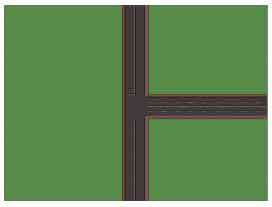
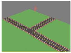
Urban road network tiles creation: For the SketchUp software, the first step is building up a terrain model. Grid was chosen to generate a terrain model with a smooth terrain (Fig. 5). Then a T-type intersection was drawn on the terrain. When textures were added to the road, road marking, vegetation, a road draft was formed (Fig. 6).
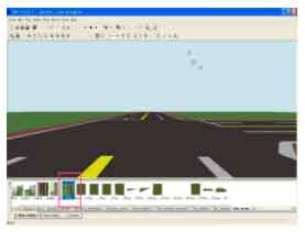
After completely building up a road file, a standard 3DS file would be exported from SketchUp software which is to used for adding appropriate lighting and adjusting textures (Fig. 7). Then, the 3DS file format should be converted to VRML file format in order to be recognized in the driving simulator. Further, the newly-built tile was put into the object gallery of BJTUDS software with a Corresponding root directory.
 | |
| Fig. 6: | Building up road draft |
 | |
| Fig. 7: | Model perfection |
 | |
| Fig. 8: | Convert format to join tile library |
It could be revealed in the tile library and connected together to create a road network. The tile in the red rectangle is the newly-built one in Fig. 8.
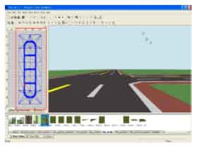
Road network modeling and environment creation: After setting up all tiles expected, the next work is assembling a variety of tiles to produce a realistic road scene. The road tile highlighted by the red rectangle is the newly-built road network in Fig. 9. It consists of 6 intersections, 8 segments and 4 curves.
 | |
| Fig. 9: | Connecting tiles to create road network |
 | |
| Fig. 10: | Add driving environment |
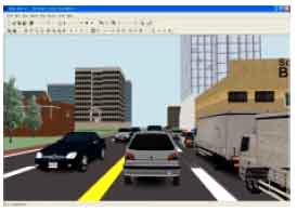
Then, the network is ready for driving scenario design and traffic environment edition and permits the generation of a random sequence of drivable tiles. Through dragging buildings, vegetations, vehicle start point, structures and ambient vehicles from the corresponding object gallery into the road network, a high fidelity virtual reality environment can be achieved (Fig. 10).
CONCLUSION
The road tile library as one of the key concepts in the driving simulator experiment greatly contributes to construction and application of typical visual databases. The tile library concept provides an easy and rapid modeling method to create road scenes. Tiles could be dragged and dropped into the scenario design interface to build up road scene efficiently. Tiles could also be replenished from road design drawings into tile library if there do not exist adaptive tiles expected. The driving environment could be added to the road tile directly. The consistent construction method has generated a library with various database elements, reducing development time and lowering construction costs. This method combined with the tools and existing tiles in BJTUDS provide a enormous flexibility in visual database generation and scenario development.
ACKNOWLEDGMENT
This work is financially supported by an “863” research project (2011AA110303).
REFERENCES
- Knodler, Jr., M.A., D.A. Noyce, K.C. Kacir and C.L. Brehmer, 2005. Evaluation of traffic signal displays for protected-permissive left-turn control using driving simulator technology. J. Transp. Eng., 131: 270-278.
CrossRefDirect Link - Antonson, H., S. Mardh, M. Wiklund and G. Blomqvist, 2009. Effect of surrounding landscape on driving behaviour: A driving simulator study. J. Environ. Psychol., 29: 493-502.
CrossRef - Vaux, L.M., R. Ni, M. Rizzo, E.Y. Uc and G.J. Andersen, 2010. Detection of imminent collisions by drivers with Alzheimer's disease and Parkinson's disease: A preliminary study. Accid. Anal. Prev., 42: 852-858.
CrossRef - Reymond, G., A. Kemeny, J. Droulez and A. Berthoz, 2001. Role of lateral acceleration in curve driving: Driver model and experiments on a real vehicle and a driving simulator. Hum. Factors, 43: 483-495.
PubMed - Suresh, P. and R.R. Mourant, 2005. A tile manager for deploying scenarios in virtual driving environments. Proceedings of the Driving Simulation Conference, November 30-December 2, 2005, Orlando FL., pp: 21-29.
Direct Link - Guo, D., A. Weeks, H. Klee and X. Yan, 2009. A framework for high-resolution geo-specific road database creation based on image processing techniques for driving simulation. Adv. Eng. Software, 40: 820-829.
CrossRef