
M.H. Asadiyan
Department of Earth Sciences, Shiraz University, Iran
A. Zamani
Geology Group, Payam-e Noor University, Ahwaz-Iran
Asian Journal of Earth Sciences
Year: 2010 | Volume: 3 | Issue: 4 | Page No.: 190-212


ABSTRACT
The aim of this study was to propose an alternative theory to Plate Tectonics. Here in, by using the concepts which Dahw (rolling) and Tahw (spreading) are carried out we try to constrain the Plate Tectonics within fractal geometric model. Dahw/Tahw is a universal phenomena/that can interpret different geological process in a self consistent model. They are induced due to stepwise revolving of Earth's Glob in the interplanetary gravitational field. Orogens rise and orogens set occur periodically due to tuning and detuning of revolver's cycloids during Earth's orbit around the Galaxy. Oceans are detuned environment or Tahw region which dissolves continents gradually, ancient continental pieces along Mid Atlantic Ridge is remnant of fine order tuned cycloids which abandon in the Tahw regions during the Earth Dahwing. Symmetry in the magnetic strip of Atlantic Ocean produces due to interference of westerly revolver's cycloids and easterly revolver's cycloids which meet each other in the MAR. Source of these cycloids are gravitation and rotation. In the global scale materials flow from Tahw cycloid-0 and accumulate in the Dahw cycloid-0, these half cycloids have maximum gravitation gradient and where they meet each other, deepest trench (Mariana) is built. Cycloids are unit cells of the Earth.
PDF Abstract XML References Citation
How to cite this article
M.H. Asadiyan and A. Zamani, 2010. Could Dahw/Tahw Dissolve Problems of Plate Tectonics?. Asian Journal of Earth Sciences, 3: 190-212.
URL: https://scialert.net/abstract/?doi=ajes.2010.190.212
URL: https://scialert.net/abstract/?doi=ajes.2010.190.212
INTRODUCTION
This hypothesis has established in 2007 when we tried to interpret the morphotectonic of Jarrahi River according to Plate tectonic model, a lot of researches show that there isn't any relation between morphology of Jarrahi River and PTM. In 2008, we noticed that mountains are also meandered like rivers and in 2009 we took this important conclusion that; whole the Earth also wrenched fractaly in itself, all these research are published in Geophysical Research Abstracts/EGU 2007, 2008 and 2009. Recent research shows that ocean ices till galaxy have fractal properties (Korvin, 1992). Escultura (2003) argued that a piece of cosmic dust as small as 0.002 microns is like a planet; it has crust and mantel like the Earth. Spherecity of the Earth indicates top degrees of symmetry and optimality, stepwise revolving of Earth Glob in the gravitational field around Galaxy induces two kind of geometry: polygon and '8'-like cycloid curves. Sears et al. (2004) argued that, rifting in Lurentia and Gondwana was occurred in regular polygonal shape, but he has not given precise address. Zemtsov (2006) studied the influence of Earth's rotation on big plates. Riguzzi et al. (2009) argued that Earth's rotation and tidal despinnig could drive plate tectonics. Herein, we succeed to detect some symmetrical elements from chaotic Earth face which could consider them as geodynamics alphabets. These alphabets are polygon, 8-shape curves and sigmoids. Here, we just give addresses of this alphabets and also try to put them together in order to build comprehensive (future/passed) sentences about the Earth. Our lighting tools in this chaotic way are main rules of the nature, symmetry and couplecity. Actually, the Earth spots like mountains, volcanoes, oceans, lakes and etc., have definite distribution and could be considered them as eye, ear and nose of the Earth's face as any other creature in the nature. The main goal in this study is make reasonable background for understanding the reality of geodynamic through constrain of the Earth's lineament within geometrical model by using Tibetan Plateau sample and origin of Tibetan Plateau by using Gorgor Sample from SW-Iran. Our data in this research are Euler's elastic curves by Sachkov (2007), which extracted during three years of geomorphologic studies by using different maps and images. So paying attention to these materials are very important to understand the general framework of this idea, some of these materials don't come in the context. At first we should introduce a summary of Dahw/Tahw tectonic by using simple experiment and then interpret the origin of Tibetan Plateau by using Gorgor Sample and Geodynamics model by using Tibetan Plateau model, i.e., we configure global system of geodynamics by using small system. It seems that orogens and taphrogens dynamics in the Earth similar to river meandering dynamics, by using simple experiments we will try to explain this dynamics.
MATERIALS AND METHODS
When we swirl a glass of tea and then take off the spoon the leaves will gathering in the center of tea glass. This shape take place due to friction difference between surface and bottom of a glass, transverse vorticity will initiate in the glass and causes tea leaves to accumulate in the center, this dynamic in the rivers will transfer materials from far bank (outer shore or concave shore) and accumulate them in the near bank (inner shore or convex shore). Certainly, if we swirl obliquely the tea glass, leave's dome will shifted from the center according to the angle of rotation axis. This is precisely what happened in the Earth. The Earth also is swirled obliquely by the interplanetary gravitational field it seems difference in the tidal forces apply torsion field between North Pole and South Pole. At the present material dominantly accumulated within eight Node regions and same quantity of Null regions (concave shore) abandon outside (Fig. 1a). These structures are produced by two dynamics in the Earth which named Dahw and Tahw.
What is Dahw/Tahw?
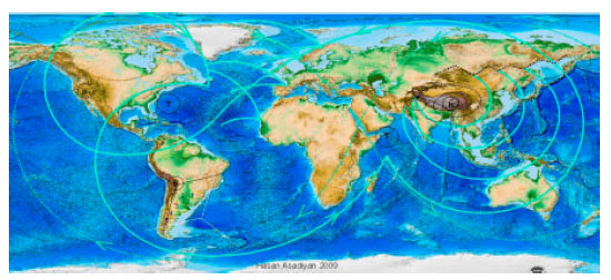
We could restrict geodynamics within Dahw and Tahw terms. Dahw in Arabic means rolling and Tahw means spreading. These two Arabic words embrace the best concept for geodynamics interpretation. While they have synonym pronunciation, they also have changeable meaning. Interestingly each term in Arabic (i.e., Holy Quran) just used one time and just for the Earth description, Dahw by converging cycloid rollers is responsible for generating polygonal shape faults (Fig. 3 dotted polygon in the mosaic); Tahw on the other hand arises to compensating the effect of Dahw by diverging cycloid rollers and converting polygonal shape to spherical shape, it seems these competing forces drive geodynamics. Like electromagnetic waves which electric and magnetic components create each other, also Dahw and Tahw components create each other, when Dahw component increased, the Tahw component decrease and vice versa. Real sample of Dahw/Tahw dynamics in global scale are shown in Fig. 1a. Global Dahw initiate between the Northern and Southern hemisphere and rolled toward Indonesia Arc, this rolling in the closed system causes huge Tahwing opposite side from Mexico Arc toward North/South Hemisphere, they are tectonically coupled.
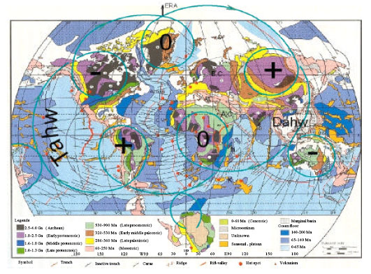 | |
| Fig. 1a: | Dahw/Tahw Model. Wandering torsion field between North pole and South pole rolled Earth blocks along cycloid paths which Dahw-ed the Earth in the in Indonesia Arc and Tahw-ed it from Mexico Arc.This model zoneate the most ancient crust symmetrically in six patterns, Antarctica also as ancient crust cutoff out side. In + pattern, spirals are converge so we have uplifting. In pattern spirals are diverge so we have subsidence and in 0-pattern spirals is approximately fixed. In Mexico Arc and Indonesia Arc which are locating between +/– pattern, maximum Earthquake activity are occurred. Interestingly orogens dominantly seen in the Dahw and Hotspots seen in the Tahw regions. Between Dahw region there is also remnant of ancient Dahw region which gradually convert to Tahw region e.g., between Greenland-Eurasia-Africa (0+0) blocks. Arabian Craton is the most ancient craton in the Earth because the upper most ancient layers, million years ago is dissolved and crop out the younger ones but in the Baltic Craton ancient layer is still remained. After one revolution promontory of the Arabian Craton(dotted orange curve) meet most recent layers; in this regard Australia considered as Ox-Bow Lakes which cutoff outside after one complete global revolution. Newzland's loop located against Australia's loop, they are considered as anomalous loops, Tasman Sea located between these two loop |
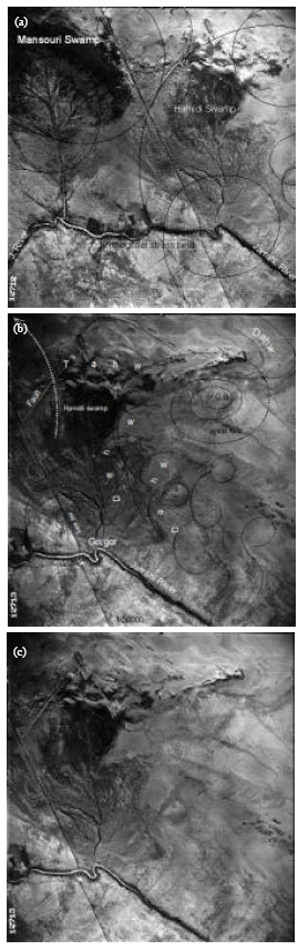
Dahw region crowded inside closed cycloid but Tahw region spread along cycloid paths (cycloid model in the corner of Fig. 2 and 1b). In Fig. 2 contact point of roller wander along cycloid path, i.e., Earth's Crust is fixed just rolled along Fermat's-Bernoulli cycloids; this cycloid is kind of Euler's Parametric Curves. Another actual sample is taken from Gorgor area SW-Iran (Fig. 3) important to image it stereoscopically. In Fig. 3, we see Dahw occur due to spiral flow of material in the Earth, so crowded inside Dahw's brackets.
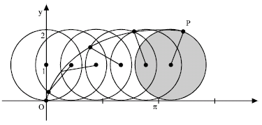 | |
| Fig. 1b: | A ball rolling on a horizontal plane without slipping or twisting, the red curve which traced by the contact point in the plane, is cycloid or Fermat's-Bernoulli curve. This is a best curve which modeled the rolled blocks in the Earth and rolled water along longitudinal profile in the rivers. +/–Pattern in the upper picture is rolled block which left Tahw cycloids behind (black curves) |
Tahw is natural response to the crust shrinkage so lefted outside of Dahw's brackets (similar to watch spring when shrink in the center opened from peripheral). Each Dahw is followed by Tahw, in global scale continents Dahw-ed in one side and oceans Tahw-ed in the opposite side e.g., in Fig. 6a when the whole earth rolled around Aleutian Trench accumulate the continents in the one side and oceans in the other side (Fig. 6a region between arc No. 3 and No. 4) produced a big polygon which named SVC-1 (Fig. 6b). Tahw similar to sea floor spreading and Dahw similar to subduction in the Plate Tectonics Model. In Fig. 3c, circulation of material accompanied by interesting stress field which has fractal geometry, this small sample lively resembles what we have observed in the Tibetan Plateau. We see Clock Wise conical spiral flow above Gorgor Dome this spiral one of the six arms which obliquely circulate around local source galaxy model (Fig. 3b) (similar to Easterly Dahw around Rocky Fig. 6a) reflection of this Dahwing is inverse Dahwing which we see around Masouri Swamp (similar to Westerly Dahw around Himalya Fig. 6a). Hamidi Swamp subsidies in the Tahw region between convex brackets or divergent faults and Dahw occur inside convex brackets (Fig. 3b). Pacific Ocean as a big trough also occurs between convex shores of two big divergent faults (Fig. 6a region between arc No. 3 and No. 4). Notable what we see along Hamidi Swamp and along Japanese/Kuril/Mariana Trenches are the same just the difference is in the scales. Coarse orders curves (0 and 1) usually accompanied by high seismic and volcanic activity and vice versa. As mentioned rivers meandering is small scale of Earth Dahwing/Tahwing dynamics e.g., in mountainous region or Dahw-ed region rivers meander in sharp bends with smaller wave lengths but in flat region or Tahw-ed region become flat and smooth with bigger wavelengths, in the most Tahw-ed region, oceanic crust's rivers (Atlantic and Pacific Ocean!) meander in the global scale i.e., Pacific Ocean meander in order-0 around 'O'-strip, but Atlantic meander in order-1 inside 'S'-strip (Fig. 6a). maximum Dahw occurs in the Himalaya and maximum Tahw occurs in the Hawaii (Fig. 6a region between arc No. 4/3and 3/4). In the rivers we see sediment transfer from concave/outer shore and accumulated in the convex/inner shore due to deceleration in the vortex current, it seems this dynamics occur in the global scale e.g., material transfer from 'S'-0 concave shore No. 4 and accumulate in the 'Z'-0 convex shore No. 4, hence deepest trench 'Mariana' is formed between meeting arcs (Fig. 6a).
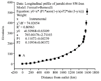 | |
| Fig. 1c: | Longitudinal profile of Jarrahi River well fitted with Fermat-Bernoulli's equation, i.e., Jarrahi rolled down along cycloid's path. This fitting attained after one harmonic, hence the main parameter is radius of roller (a). After pi rolling, maximum elevation point gives length of river which is approximately equal to the diameter of roller |
Galaxy-model explains well D/T dynamics (Fig. 2 and 3b), In Galaxy-model we see peripheral materials have retrograde flow with respect to the central bar (also look to the fountain symbol in Fig. 4a). Hence, we could claim that orogenies in the Earth isn't outcome of sea floor spreading and plates impaction but inversely sea floor spreading is resultant of crust shrinkage (Dahwing). So we always see orogen inside divergent faults and taphrogen outside divergent faults. The other difference is-material transformation in the river occur in the plan but in the Earth occur in the sphere e.g., rivers meander in 'S'-like paths but Earth meander in '8'-like paths (cycloid shown in Fig. 2a, 1b), we tested this idea in small scale in the Longitudinal profile of Jarrahi River and global scale (Fig. 7 scorpion-like curves) both them well fitted with Parametric Curves, the first one (Fig. 1c) with one harmonic and the second one (Fig. 10a) with ten harmonic (Simones, 1972; Asadiyan and Zamani, 2009) i.e., Jarrahi rolled down along cycloid's path, the length of river is equal of cycloid's diameter. In this model material transfer from Oceans and accumulated in the four cardinal points within '8'-like cycloid system (Fig. 4b, c). The '8'-like strip formed from conjugate 'S'-1. 'S' curve and Fermat-Bernoulli's is two kinds of optimal curves and connect to successive spiral (model in Fig. 2a, 4a), the main character of optimal curves is; minimum energy expenditure. Earth D/T in single pole base ('O'-0) causes initiation of continents in the N. hemisphere and oceans in the S. hemisphere. We see in Fig. 6a continents bounded by 3 and 3 brackets and ocean in the S. hemisphere by 4/3 and 3/4 brackets. In Fig. 4b Okhotsk, Japanese, Yellow Seas and Hudson Bay located between minor divergent faults. Cube and its corresponding '8' are two main tools for dissolving geodynamics mysteries.
Polygons/Quasi Cubes
Polygon is projection of cycloid flow of material in the Earth's crust (model in Fig. 2a and 3d). If you look at the bathymetric map from distance (in order to filter the small lineament), you see it looks like a big six sided tent which spread above world ceiling roof; Tibetan Plateau and its main rod (Ninety East Ridge/NER) have driven in the Indian Ocean (IO) this is a first Earth unveil (Fig. 5b). Upper tri-edge intersection (Continental Triple Junction/CTJ) of this polygon/cube exactly located on the Everest and lower tri-edge intersection (Oceanic Triple Junction/OTJ) exactly located on the Mariana, half circle/Euler Elastica (Java and Sumatra Trench) connects this two minimax points.
 | |
| Fig. 2: | (a) The D/T dynamics in two scale; 1- In Global scale Earth bended around D, 'Z'-1(heavy)and'S'-1(dashed line) are two geodetic lines which connects N/S extreme boundary of the Earth in this figure Earth Glob Dahw-ed around Aegean Sea. 2- In smaller scale white spiral which build Kopeh Dagh cube Dahw-ed around K loop, there is conjugate 'S's flow connect N/S boundaries of this loop, triple junction of this cube shown by black lines. It seems the Earth tuned reversely between NPandSP around cycloid path similar to upper right corner model, this model show relationship between '8' element and cube element, upper cycloid matches with upper face and lower cycloid matches with lower face's cube, elevation difference between successive cycloid about 1/8 cube's elevation. There are two concave thin shores bounded Iceland from East and West and two convex thick shore bounded Himalaya from the East and Rocky from the West. Notice 'S'-1 passed through lower altitude points (Biscay and Red Sea) but 'Z'-1 passed beside high altitude points (Himalaya, Zagros and Alps). Iceland located in crossing region of vertical saddle's axis(Atlantic) and Earth's surface, Siberian Upland located in center of upper loop and Cameroon Mts. located in the center of lower loop (b) Galaxy is the best model which fitted well with actual Earth, Africa/Baikal located where Dahw/Tahw arms diverge. Look to the Carpathian Mts. which connects two bounder of Dahw loop? It seems Africadiverge between Arabian arm (No.3) and Anatolian arm (fine dashed No.2) in this regard Mecca as a first Dahw-ed point at the present experiences Tahw regime it is located in the center of this triangle. Cameroon necklace Mts. locating in the center of D/T (brown/orange) crescent |
 | |
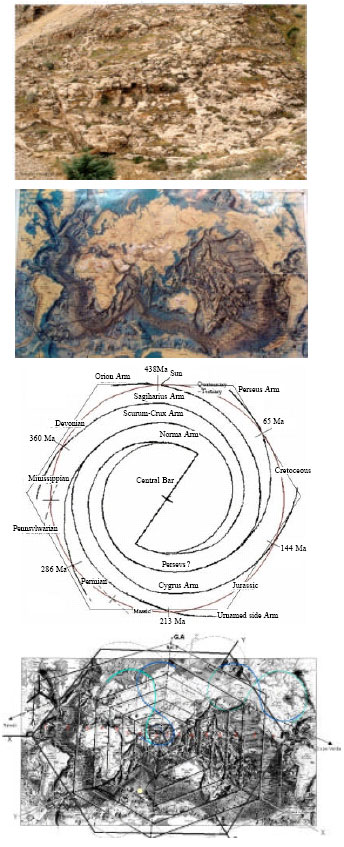
 | |
| Fig. 3: | Dahwing/Tahwing samples from Gorgor System → Himalaya System → Earth System. Try to look them stereoscopically. Compare element of 'Polygon', 'Conical spiral' and 'bilateral stepwise' faulting in Fig. 3b, d and e. In Fig. 3a, we see Earth's layers recumbent toward N-E and N-W by inverse cycloid systems, Hamidi Swamp initiated between these divergent folding and Mansouri Swamp initiated in the bending region of N-W recumbent. In Fig. 3b big arms around Central Bar (CB) show oblique swirling of material which build different folding, reaction of this Dahwing is inverse Dahwing which occured around Masouri Swamp, D/T region repeated six times around Gorgor's dome similar to galaxy model beside Fig. 3d. Look to the sharp orthogonal stress field which is originated between these inverse Dahwing Fig. 4a. Conical spiral vorticity accompanied by interesting stress field Fig. 3c. Hamidi watershed originated between divergent faults Fig. 4b. Abrupt change of river's course from NW-SE to NE-SW follows divergent faults Fig. 3b. In Dahw-ed region, material inversed with respect to crossing point. Look carefully to the relationship between dashed polygon and Dahw-ed layer and black arrowed cycloid in Fig. 3d. The same dynamics we see in yellow polygon Fig. 3e and EEC in Fig. 3d all them divided three distinct convex faces. This sample lively resemble what happen to Tibetan Plateau, and TP's sample lively resemble what happen to the Earth Glob, as we see there is a similar structure between two different scales Fig. 3d and e. Compare the geomorphology of bilateral stepwise faulting in Fig. 5d and e(arrow show stepwise subsidence and curved arrow shows stepwise layer's rotation). Figure 3d is Unit Cell of Galaxy Model in Gorgor area, in this picture cycloids facing each other but in Fig. 3a they are backing each other. Sink Galaxy Model is shown inside white circle (similar to Bermuda in small scale) located in the center of Unit Cell, Source Galaxy Model (similar to Himalaya in small scale) shown in grey circle and black circle is cross region (similar to Aleutian in small scale), the direction of stress field in these two model obey Left Hand Rule. Notice how Gorgor and Himalaya's conical spiral passed through finer spirals Fig. 3e. Notice Ox-bow Lake beside Jarrahi River formed in the region where conjugate systems meet each other Fig. 4b, accordingly we could say; Aleutian is oxbow of the Earth Fig. 3e |
 | |
| Fig. 4a: | These are key figures for understanding general framework of geodynamics and relationship between its main elements i.e., spirals, '8'/'S'-shapes and cubes. The origin of these elements is Earth's rotation which like a fountain abandons cycloid spirals. D/T dynamics produce cross arrangements of continents and ocean, as seen Pacific in the opposite side of Atlantic and Eurasia in the opposite side of America. Notice how fountain arms in different level make Node-Null spiral paths. It seems each fountain's arms circulate Earth's radius in 4 steps. Origin and migration of orogens relate to the origin and migration of these cycloids. Notice how Yellow cube originate due to differential circulation between N.fountain and S.Fountain. Convex faces of this cube represent three distinct zones and located in the West face of EEC (Pacific), CTJ located on the Guiana orogen and OTJ located on the Philippine Trench. Elevation difference of CTJ-OTJ is about 1/8 cube's height. Also notice the relationship between spiral's segments and SVC's/CVC's edges and relationship between Dahw-ed layer (dashed red curve) and yellow polygon, the relationship between spiral and '8'-like path (big dashed 8). Blue 'S' curves connect upper loop of Tahw and lower loop of Dahw. In T-domain or D-domain we see smaller component of D/T domains. It seems these domains represent different ages. This figure clearly shows how concentric SVC/CVC rotates with respect each others. Segment 4 corresponds to one of SVC's edge and segment 3 corresponds to one of CVC's edge. Notice carefully how formation of different spots corresponds to scales e.g. Hawaii and Kerguelen volcanoes originated in the divergent region of order-1 spirals (black/grey dotted spirals), East African Rift originate in the divergent region of order-2 spirals and so on Fig. b. Black cycloid and grey cycloid convege toward Indonesian Arc. (b) Schematic sketch of Dahw/Tahw tectonic model or Pole-Pole torsion field model show, 1- black / grey D/T-1 Strings twisted completely four times represent in four different level horizon by horizon around NP, Okhotsk, Baikal and Himalaya. 2- Dashed curves show Elastic Trajectory between Dahw-Pole and Tahw-Pole. 3- Cycloid circulation of material (D/T Sigmoids envelop of these cycloids). 4- Yellow Sea, Japanese Sea, Okhotsk, Hudson Bay, Baffin Bay and Biscay Bay originate between minor D/T string (divergent faults) and Pacific Ocean originates between major D/T strings. 5- Position of D/T axes with respect to Earth Spin Axis. 6- Position of NER and NR with respect to Elastic Trajectory. 7- Cape Verde in the crossing point of '8'-Dahw and Hawaii in the crossing point of '8'-Tahw. 8-Pacific Ocean opened around Aleutian Trench and Atlantic Ocean opened around Sandwich Trench. 9-notice; African�s Curvature matches with Tahw string curvature but South America�s Curvature in opposite vergence with respect to Dahw string, this cause's sharp converging in Aconcagua mountain and strong rifting in East Africa. 10- Rocky, Himalaya, Kilimanjaro and Aconcagua located in the curvature centers of D/T strings. Sketch stretched along E-Spin Axis to show all continents |
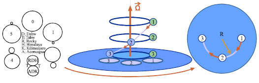 | |
| Fig. 4b: | Initiation of Dahw nucleus and progressive growth of D/T cells, as seen they have opposite growth relation. In balanced model (No. 3) Himalaya/Andes and Rock/Kilimanjaro located diagonally. Cape Verde located in cross point. (d) Earth like a big ball has been dropped in the interplanetary gravitation fields. A ball moving vertically along the axis of rotation in an inertial frame appears to spiral downward in the rotating frame. The rate of rotation |O| = ? is assumed constant in time. A ball dropping vertically (parallel to the axis of rotation O of the rotating frame). For simplicity, suppose it moves downward at a fixed speed in the inertial frame, occupying successively the vertically aligned positions numbered one, two, and three. In the rotating frame it appears to spiral downward. (e) The right panel shows a downward view and top view of the circular trajectory of the ball in the rotating frame. Because it drops vertically at a constant speed, from this top view in the rotating frame the ball appears to move at a constant speed around its circular track |
This scenario repeated with respect to Guiana Yellow Cube in Fig. 4a, we see CTJ divided this fraction into three distinct parts which are Pacific fraction (biggest water fraction and contain most world wide seamounts) in the East face, Eurasia fraction (ocean and land) in the West face and Australia (biggest land) in the South face. In Fig. 9, we see Earth polygon fractalization till order 5 and in Fig. 6a; we see Earth 'Z' fractalization till order 5. OTJ divides also three distinct concave faces into the Tahw-ed partion (Pacific Ocean). Global polygon is named Earth Equivalent Cube (EEC). We used Cube term instead of polygon in order to simulate Earth topography three dimensionally. EEC or SVC-0 (cube order zero) fractalize in order of 23. It seems Earth diameter (Appr. 12800 km) is a unique number in the solar system and as 23 order of Galaxy size. Edge of Himalayan Cube (SVC-4) as well as other Nude/Null polygons is fractal components of Earth glob (SVC-4's edge = 1/8 Earth diameter). In Fig. 1a we see also eight cycloids bounded whole the Earth glob. Interestingly edge size of six sided polygon of actual picture from Iran/Shiraz in Fig. 3a, is about 48 m which is fractal component of EEC's edge size; accordingly we could conclude that Earth Glob size is also fractal component of Galaxy size. Escultura 2003 argues that a piece of cosmic dust as small as 0.002 microns is like a planet; it has crust and mantel like Earth. This harmony encourage us to search more in the topographic map of the Earth, after much studies and a lot of trial and error, ultimately we find also 8 EEC's which have intergrowth into each other. In this relation any corner makes another cube corner with specific displacement equal as SVC-4's edge. SVC-1 smoothed by seven Node/Null spots their size equal as SVC-4 (Fig. 6b). In 0-order also common rectangle face is seen between Himalayan Cube and Rockyan Cube as equal as Pacific Ocean (Tahw partion of Earth Glob), this rectangle with respect to Himalayan Cube make east face and with respect to Rockyan Cube make west face (Fig. 3a) (just two legs of Rockyan's triple junction shown).
  | |
| Fig. 5: | Upper pictures-similar geometry in three scales, showing a- about 100 m picture from Iran/Shiraz shows three zone separated by triple junction, six edge of this polygon is well obvious, edge's length of this polygon (48 m) is order of Earth's diameter. b- Picture of bathymetric map of the Earth which also shows three distinct zones which separated by triple junction (Tibetan Plateau in the central bar). c- 100000 light years schematic drawing of galaxy model with six arms, in general also looks six sided polygon. Red curve is CW orbit of solar system around the Galaxy. Detailed description as, d- Tectonic elements of the Earth. Showing 1- thick black polygon is SVC-0 or Earth Equivalent Cube (EEC) and CVC-1 (thick grey polygon), 2- centricity of Tibetan Plateau and CTJ (XYZ) between three distinct convex faces of Himalayan Cube (black small cube around Himalaya or SVC-4). Eurasia, Pacific and Atlantic plates located in the N/E/W faces of EEC, Ural/Pacific Center/Cameroon Mountains located in the center of these faces. 3- centercity of Mariana and OTJ (grey Triple Junction/XYZ) between three concave faces of Mariana cube. 4- Geotectonic Axis (GA) Passing through NER, centers of Dahw-Moebius strip and Tahw-Moebius strip (dotted fine 8 in the NGP/SGP) and '?'(convergent symbol) in the NGP and '?'(divergent symbol) in the SGP. 5- Global curves 'S'-1 and 'Z'-1 or orthogonal Himalaya/Hawaii ended geodesic lines, 'Z'-1(black curve) rotate progressively and convert to 'Z'-1(grey curve). look carefully to the fractalization of 'S'-1, e.g. 'S'-2/'Z'-2 in the north loops of 'S'-1/'Z'-1 and localization of Aegean Sea and Japanese Sea with respect to 'S'-2/'Z'-2. 6- Conjugate 'S'-3 (black small curves) around Aleutian/Australia cubes. Notice how Aegean Sea's Tongue and Cape Verde's tongue like flower extracted from Red Sea in opposite direction, inverse twisting of Aegean Sea's/Japanese Sea's tongues ('S'-2/'Z'-2) system Dahw-ed Himalaya at present (and Dahw-ed Ural and Novaya Zemelya in the past, it seems at present these are experience Tahw period), but in North America they are spread from north Canada toward SE/SW and Tahw-ed Rocky. e- Source Galaxy Model of D/T arms around Himalaya. CVC-1 is first rotation of multi spirally cubes start/end in the Gulf of Mexico, one relate to Dahw string and the other relate to Tahw string, 7th cycle ended around Himalayan Cube. Each red segment about 1/8 Earth diameter. There are four Arctic's (Pacific/AtlanticandEurasia/America) CVC-1 and four Antarctic's CVC-1. In Himalaya Cube and Rockyan Cube's model CTJ and OTJ completely intergrowth against each other which causes Tibetan Plateau and Rocky Plateau to bumped up in Dahw-ed region, but in Pacific Cube and Atlantic Cube's model (dotted black lines) CTJ and OTJ spread against each other which cause Pacific Ocean and Atlantic Ocean to bumped down in Tahw-ed region. Common corners of these eight cubes have phase lag about 1/8 Earth's diameter which make anomalous cube. Also here distinct spots like Baikal/ Guiana Trench/Victoria Lake located in the center of N/E/W faces of CVC-1. 7- SVC-2, 3, 4, 5 also illustrated with white cubes in the Pacific. Iceland Volcanoes in the NW Tahw-ed region and Kerguelen Volcanoes (Yellow spot) in the SE Tahw-ed region |
There are four Arctic and four Antarctic cubes which their vertical component of triple junctions vergences toward Arctic and Antarctic. The Arctic cubes are (N.America-N. EurasiaandN. Atlantic-N. Pacific) divided by '+'-like shape which ESA passes through cross hair. Greenland-Barents Sea is Head-Tail connection of Continental Sigmoid and Iceland-Arctic Ocean is Head-Tail connection of Oceanic Sigmoid (Fig. 4a). The main question that here arises is how this quasi cubes generated?
'8'-Shape Curves
The second important element is conjugate 'S' or '8'-shape curve which is actually an optimum path connects successive spirals (Fig. 1a, 2a and 3d). The '8' is traces of cycloids in the Earth. We could consider polygons and cycloids as unit cells of the Earth. '8' has two components; Dahw eye and Tahw eye (Fig. 4b). This symbol represents smooth aspect of the Earth and cube represents ragged aspect. Earth Equivalent Cube or SVC-0 enveloped by Earth Glob or 'O'-0, in Fig. 5d we see also Australian Cube and Aleutian Cube (suborder of SVC-0) in S/N hemisphere enveloped by conjugate 'S'-2. Australian's cycloid and New Zealand's cycloid's make upper and lower faces of Australian's Cube. In Fig. 5b, we see 'O'-0 born in the bulge of Dahw/Tahw sigmoid. O-0 formed from '('-0 and ')'-0, one bracket represent Tahw margin and the other bracket represent Dahw margin, one order ahead, O fractalize into four smaller circles or pair '8'-1 (with different eye size and inverse vergence) also each one formed from Dahw/Tahw eyes and have common centers (IC and SC), one order ahead, '8'-1 fractalize to pair '8'-1 (each 8's eye will convert to smaller 8 ) shown with black/dotted and grey/dotted curves in Fig. 5a. In O''', O is smoothed by 84 SVC-4 (Fig. 5b). In this regard global fractotectonic model-0/1 (Order-0/Order-1) derived from topographic map of the Earth. In Order-0 (single pole/Aleutian) Dahw/Sigmoid originates from Kamchatka and ended in the Gulf of Alaska. This sigmoid with central point No. 4 is responsible for continents formation. Tahw/Sigmoid originates from Gulf of Alaska and ended in the Kamchatka. This sigmoid with central point AC is responsible for Oceans formation. Upper/lower boundary of D/T Sigmoid have maximum gravitation gradient (shown with dotted black/grey Moebius Strips) fractal stress field arises between these two minimax boundary e.g., we could consider 'S'-1/'Z'-1 as optimal gravitation circuits which connected these boundaries (Fig. 2a, 6b). Stress field rose when Earth's spring tuned from Aleutian Trench. D/T Sigmoids nodded in the anomalous polygon (Aleutian Trench and Australia) i.e., Earth Globe subjected to one complete twisting with one Node in the Aleutian Trench, in Fig. 1a, we see complete twisting around Australia they are like Ox-bow lakes which abandon after one complete twisting (Fig. 1a, 6b). Also in Fig. 5b, we see two Moebius Strip propagate symmetrically from NGP/SGP toward E/W. Big eye of 8 is EEC and small eye is SVC-4. Order-1 is suborder of previous one, when Earth's Spring tuned from NP/SP, conjugate cycloid '8'-1 originates in bulge of 'O'-0 and connected North boundaries to South boundaries, in this regard East's layers circulate towards west and West's layers circulate toward East (similar to what mentioned in Mansouri and Hamidi Swamps Fig. 3a), conjugate 'S'-1 propagate symmetrically toward N/S Poles i.e., Earth Dahw-ed itself between two points, in Fig. 4b, we configure also Pole-Pole Sigmoid model extract from actual Earth and show Earth crust bended spirally toward East and West, enveloped by sigmoidal paths, in progresses stage Holmes Strip (O) convert to Moebius Strip (8), in advance stage which influence whole Earth's Body catastrophic event happened i.e., North America splited from South America in the West and Africa/Australia splited from India in the East.
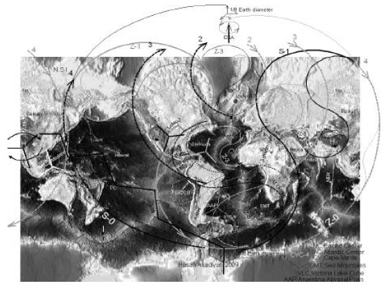 | |
| Fig. 6a: | The EDT Model in three orders. In global scale (Order-0) the Earth wrenched between two galaxical wings (concave cycloid No. 4 and convex cycloid No. 4) which revolving against each other; where they are meeting each other produce deepest trench (Mariana). Australia located between south divergent cycloid and New Siberian Islands located between north divergent cycloids. The Earth material meandered inside 'O'-like strip between 4/3 and 3/4 arcs, in this strip most Dahw region is Himalaya and most Tahw region is Hawaii. In Order-1 the Earth wrenched inside '8-1'-like strip between 3/2 and 2/3 arcs, in this scale most Dahw region originate in the Rocky and most Tahw region originate in the Ural and Novaya Zemlya, in the south loops the most Dahw region originate in the Andes and most Tahw region originate in the East African Rifts. In Order-2 the Earth meandered inside '8-2'-like strip between 2/1 and 1/2 arcs, in this scale when D/T field's tip (2 and 2) stretching against each other originating Greenland. In '8'-2 model, Mexico/Saharan orogens located in the N-Hemisphere convex shores of the model and Andes/Africa orogens located in the S-Hemisphere convex shores of the model and Bermuda/CV and ST/SMT located in the concave shore crescents. Z-3 smaller order of EDT model shown by black curve between 2/2, follow bigger scale of 'Z' which formed by 2, 3 and 4. Smallest order/Z-5 curved around Anatolian and Iran Plateau. Thick broken line is bilateral expansion steps of Atlantic and lateral expansion steps of Pacific which connect Himalaya to South Pole |
We should image '8'-1 shape 3 dimensionally with two perpendicular saddles. Pacific Ocean (Pacific Cube/PC) formed in the horizontal saddle and Africa and America with adjacent ocean (Atlantic Cube/AC) formed in the vertical saddle (Fig. 5a) projection of this shape in Mercator looks like a kidney (Fig. 5a).
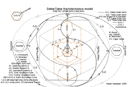 | |
| Fig. 6b: | Global D/T tectonofractal model derived from topographic map. In this model Earth Glob wrenched around Aleutian spot produce model-0 with single pole and rotated model-1 with dual pole. Single pole is '8'-like model in the Earth Plan with two different eye sizes, i.e the Earth Glob Dahwed asymmetrically around SVC-1(dashed black cube) and abandon Aleutian Cube as an Ox-Bow lake on the other side. Dual pole is conjugate '8'-like model in Earth glob which Dahw-ed symmetrically around CVC-1(dashed grey cube). SVC-1 has retrograde motion with respect to CVC-1. model-1 composed of two different eye sizes ('O'-1 and 'O'-2) with inverse vergence between NP/SP. combining of this system making conjugate 'S'-like meander paths which Rocky/Himalaya located in the N-Hemisphere convex shores and Andes/Kilimanjaro in the S-Hemisphere convex shores and Pacific Ocean in the concave shore crescents. There is maximum gravitational gradient between roof and bottom of conjugate 'S'-1/'Z'-1 hence we see maximum meandering (lateral shifting)of Atlantic and maximum subsidence (normal faulting blocks;1, 2, 3, 4, 3, 2, 1 or Earth's cleavages) occur along couple 'S' |
AC and PC (continents/oceans) is the most dominant suborder cubes of EEC, which are separated by Ninty East Ridge (NER) and Nazca Ridge (NR). 'O'-0 shown with dotted subcircle in the topographic map (Fig. 5a). When conjugate Dahw's brackets of 'O'-0 {i.e., '('-0 and ')'-0 or ')'-0 and '('-0 }converging generating continents in the convex faces of EEC, at the same time opposite side experience diverging dynamics and generating oceans in the concave faces of EEC (Fig. 5a) arc No. 3. Upper corner (CTJ) and lower corner (OTJ) aren’t exactly over each other but shifted in E-W direction a distance about Pacific size. 'O'-0 fractalize into two '8'-1 or conjugate 'S'-1('S'-1 and 'Z'-1 in Fig. 5a). 'S'-1 has two tongues, upper one vergencing toward NW and lowers one vegencing toward SE and conjugate of 'S' (looks like 'Z'-1) is represent oceanic margin also has two tongues vergencing toward NE and SW upper tongues of conjugate 'S'-1 tuned by T/D pole and lower tongues tuned by D/T pole so when upper tongues of conjugate 'S'-1 converging generating convex faces of C-2 (Iceland Cube/IC) on the other hand, when lower tongues diverging, generating concave faces of C-2 (Atlantic Cube/AC).
 | |
| Fig. 7: | Elastic Field Trajectory (EFT) is connection of east-west cycloid system enveloped by one cycle of global '8'-like of material flow (crossing point in the Red Sea), Bermuda in the center of west eye and Himalaya in the center of East eye. East cycloids have excess Dahw with respect to west cycloids. Stress field tuned between D/T-Poles by gravitation forces in opposite directions. In the west part orogen partitionized into north nude (Rocky) and south nude (Andes) against huge east nude (TP) which located between Japanese Null and African Null. Tahw-ed region shown between CTJ (black) and OTJ (white) in the South America cube. Meobius strips (dotted orange curve) with inverse vergence shown in NP. Africa bended around old Cameron necklace mountains (Sent Helena Volcano is center of curvature) within old FET shown with dashed red curve, Alp-Himalaya Belts are raised in the promontory of this old FET cell. Cameron mountains have been the same tectonic setting which Himalaya have at the present and Arabian Craton have been the same tectonic setting which Aleutian Trench have at the present. As Earth tuned around Himalaya, attract North America and causes Pacific to close from the West, four abandon traces of EFT remnant of continental attraction |
Upper corner and lower corner aren’t exactly over each other but shifted in N-S direction equal a distance between IC and SC (Fig. 5b). This distance summation of lateral shifts which occur along transform faults between these two minimax triple junctions with elevation difference about 1600 km i.e., crust generation isn't restricted just along mid oceanic ridge but also generates along transform faults. These two cubes have opposite vergence, i.e. vertical component of IC triple junction vergences toward Arctic but vertical component of SC vergences toward Antarctic, AC located between IC and SC. In the uppermost C-2/IC matches with upper smaller eye and lowermost C-2/SC matches with lower smaller eye and AC formed among these two in the Tahw part. When coarse grain circular carpets rolled apart, Atlantic Ocean fell down in the Atlantic's Graben and abandon finer carpet behind which build Mid Atlantic Ridge (Fig. 4b).
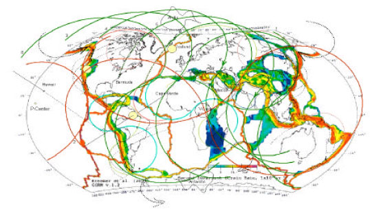 | |
| Fig. 8: | The'8'-like circulation paths of material inside the Earth from order 0 to 3 using global strain map and age map, showing 1- close relationship between GSRM and fractal setting of 'S'-Curves, Intensity of strain related to ‘S’-order super position e.g., superposition of Z-0 (green) number 6 and 7, Z-1 (pink) and Z-2 (yellow) with No. 1 cause maximum intensity in the Japanese/Kuril/Mariana Trench and South America. 180 degree progressive circulation of Dahw curves around Pacific Ocean. After 8 step, propagation rotate about 90 degree and convert from NW-SE (No.8) to NE-SW (No. 1). Also after other 90 degree in the Pacific Ocean, No. 8 converted from Side-Side Propagation (red curve No. 2). In general they are circulating in '8'-like path. Notable Earth covered by two kind of this curve, Oceanic-'8' (red curve) and Continental-'8' (not shown) they are coupling each other. Different location produces different tectonic setting e.g. central location produce twisted rope-like orogen (Zagros) but asymmetrical position produce circular twisted orogen (Himalaya) also Himalaya and Bermuda have similar position with respect to Aleutian Trench. In the last step Z-mode convert to S-mode so inverse Tahw circulation occurred simultaneously with S-0(red) this curve circulate around two active volcano. San Andreas Fault located between facing part of S-0, also numbers 1 and 2 circulate around two definite spot, where Z-0andS-0 are cross each other produce Tensile-Sea (Mediterranean, Yellow, Japanese and Okhotsk Seas). 2- S-0, 1, 2 are shown from heavy red to light red in 'Z' No. 2 aroun Hudson. 3- Compare three recumbent fold with 'o'-Symbol in the inflection point and position of Himalaya, Kilimanjaro and Aconcagua with respect to these shapes. Aleutian gates and Sandwich Gates aren't parallel but make makes 45 degree with each other. Notice direction of rolling around Himalaya and Iranian Plateau. Iranian Tongue attracted toward Central Bar |
When two successive cycloids offset each other, subsidence region (Mediterranean Sea) formed in the offset area (Fig. 2a). This part located among two limb of couple '8' so subjected to maximum rotation and gravitational gradient (similar to gravitational potential between upper/lower limb of 'O'-0) since we see maximum subsidence and normal faulting occur symmetrically with respect to point 4 along 'S'-1/'Z'-1 arcs, these arcs tangent with left/right step faulting, Biscay Bay located between step 3 and 4, Aegean Sea located between step 2 and 3 and Caspian Sea between step 1 and 2, symmetrically in the West hemisphere we see Gulf of St. Lawrence located between step 3 and 4, Chicago and Michigan circular lakes between step 2 and 3 and Utah and Colorado lakes between step 1 and 2. We could consider these steps wise faulting system as Earth's cleavage.
 | |
| Fig. 9: | The CVC-Base background of the Earth Plan, (try to look it three dimensionally), showing; 1- Fractalization of the Earth Plan into eight EEC's: four Arctic CVC's-1 (HC/RC and AC/PC) and four Antarctic CVC's-1(HC/RC and AC/PC). In AC(black cube)/Arctic-Base: Iceland/Victoria lake/Cocos (smallest green Cube) in the center of north/east/west faces and CTJ vergences toward SP (SC). In AC/Antarctic-Base: SC/Victoria lake (smallest Green Cube)/Cocos located in the center of south/east/west faces and OTJ vergences toward NP (Iceland), cube frame shifted upward about edge of Anomalous Cube HC or RC. (Extension of North face shown with dotted line beyond the figure frame). This scenario also repeated for PC, HC and RC. 2- AC and PC aren't completely side by side but have a phase lag about HC-edge size (distance between adjacent spirals). 3- CV / SP / Hawaii in the center of north face of AC / HC / PC. 4- Iceland/Himalaya/AC/Rocky in the four corner of AC/N. face, this cube has the best compatibility with actual Earth. 5- Inside of north/east/west face of each cube will be another small cube e.g. C-5 in the N. face of C-4, C-4 in the N. face of C-3, and so on to reach EEC-0, bigger than EEC it seems masses folded inside the Earth globe due to boundary condition. According to this model, main Earth spots will have harmonic distribution e.g. distribution of Himalaya, CV and Hawaii have symmetries (mass concentration spot between two mass dispersion spots), as masses disperses between IC and SC in the Atlantic Cube, masses concentrated in the center of Eurasia Cube. Notice that Himalaya accumulated in north face of HC but Rocky accumulated in the west face of RC, it shows that RC rotate about 90 CCW with respect to HC. In the Rockyan Base Model, TJ (thick grey line passed through NR) located on the Mexico and Victoria Island / AC / Pacific center located in the center of N/E/W. faces. Corners of Rockyan Base Cube are shown with grey angles which are located on the significant spots. Notice carefully when Rocky and Australia extended their triple legs (Tahw), Himalaya and Andes on the opposite side bumped up (Dahw) |
Thick broken lines in Fig. 5a are bilateral expansion steps of Atlantic and lateral expansion steps of Pacific.
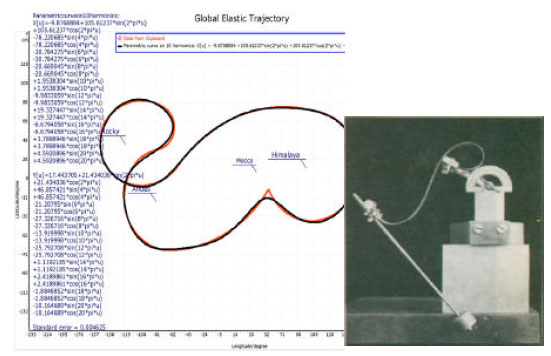 | |
| Fig. 10: | (a) More complex curve of Scorpion-like Global Elastic Trajectory after ten harmonic fitted over parametric equation with standard error = 0.004625 (data extracted from Fig. 7). Mecca located after 180 degree i.e. it is cited in the center of GET model and could be the first point which subjected to tectonic. (b) MaxBorn experiment Sachkov (2007), showing achievement one kind of Euler's Elastic Curves by hanging masses to fixed elastic rod, The ends of rod bended in opposite direction, interestingly this shape very similar to GET between East-West anchors and could have many information for us. Notice Himalaya, Andes and Rocky located in the center of convex shores |
It seems that Hawaii and Himalaya have conjugate symmetry i.e., Hawaii is a biggest Oceanic Mt. and Himalaya a biggest Continent Mts. In this regard we see Hawaii in the curvature's center of 'Z'-1 and Himalaya in the curvature's center of 'S'-1 (Fig. 5a). This research also detected fractal relationship in two dimensions.
Look at the Fig. 6 this is a cycloid path of Earth meandering (Earth's material flow), in general material flow along '8'-like strip with two suborder fragmentation- big Tahw occur in the west between N-America and S-America and minor Tahw occur in the East between Africa/India from one side and Australia/India from other side, these region characterized by volcanoes (Fig. 1a). Cross point of '8' which passed through Red Sea could be considered as the first Dahwing point in the Earth because upper most ancient layers (brown, purple and blue layers) is dissolved and crop out the green layer. The important note here is; two fragmentations are not parallel but make 45 degree with each other due to east Dahw excess with respect to west Dahw (Fig. 7 dotted arrows in the PN and SP).
Correctness Marks
All curvature's centers of 'S's or centers of cube's faces according to they order accompanied by small or big polygon-like spot marks. Look to the Fig. 3, 5e, 6-9 e.g. in Fig. 1 and 5a we see even 'Z'-3 has Azores and CV Island in its curvature's center, correctness marks in Fig. 8 shown by colored spots. So any 'S' curves or cubes which haven’t any Earth's mark aren't valid. The entire lineaments which we plotted in this study have correctness marks.
Dahw/Tahw Evolution
Here we explain the evolution of Dahw/Tahw daynamics in the Earth using coarse orders of fractal geometry.
O-step or order-0. This step reveals primary period of the Earth's history. It represent primordial quasi glob of the Earth planet, in a rough approximation we consider this O-ring as a small neutral circle then due to tidal force difference between North Pole and South Pole it kinked from N/S pole and convert into two Dahw/Tahw Moebius Strip. O-ring partitationized in Dahw-bracket '('-0 and Tahw-bracket ')'-0 (Fig. 5a) bracket 4 and 4. As Earth's Crust shrink rotationally at the N-pole, they are dragged materials away from S-pole and accumulated them between Dahw's convergent faults (Fig. 5a arcs 3 and 3) which named continental part (Eurasia and America), the rest abandon outside between Dahw/Tahw crescent (4/3 and 3/4) and named oceanic part (Pacific/Indian Oceans). Interestingly this model is similar to the section of the Earth's structure i.e., inner Core located between 2 and 2 and Outer Core located between 3/2 and 2/3, Mantel located between 4/3 and 3/4 and contribution of the Crust is a thin sector which lies between 4 and 4.
It seems that continental block in the N-hemisphere is superposition of easterly and westerly '8'-1 rolled layers, accordingly oceans originate in the S-hemisphere as reaction of Earth Dahwing in the N-hemisphere. Himalaya/Kilimanjaro located beside ')' No.4 and Rocky/Andes located beside '(' No.4, Fig. 5a. In this step the Earth is begun to polarized by gravitation potential from Red Sea, hence, Arabian Craton is the most ancient craton in the Earth because upper most ancient layers (brown, purple and blue layers, look to the legend of Fig. 1a) is dissolved and crop out the green layer, but in the Baltic Craton just brown layer is dissolved. The A.C. located beside most recent layers and Zagros Thrust detached them. Important note here is, this O-ring obliquely sited with respect to ESA, this specific localization in the space cause different tectonic setting between E/W sides of Pacific Ocean, because East Tahwing synthetic with ESA but West Dahwing antithetic with ESA.
O'-Step or order-1. In this step 'O' convert to '8', as O-step ongoing, Atlantic Ocean initiated in the region where south loops of 'S'-1/'Z'-1 are Tahw-ed and Greenland initiated in the region where north loops of 'S'-1/'Z'-1 are Dahw-ed. Himalaya/Rocky considered as D-Pole/T-Pole of N-hemisphere's continental block. The Earth in N/S hemisphere meandered inside '8'-1 strip which Everest/Shasta located in the centers of North-eye and Kilimanjaro/Aconcagua located in the centers of South-eye (Fig. 5b). Also continental blocks in N/S hemisphere meandered along 3-2 and 2-3 arcs (Fig. 5a), which Rocky located in the north convex shore between 3-2 arcs and Andes located in the south convex shore between 2-3 arcs, Hawaii originate between these two system in the Tahw region and Himalaya originate between these two system in the Dahw region. In this step South America is being split from N-America along Nazca Ridge and Africa/Australia split from West/East side of India along NER. Actually Aleutian Gates in the North Pole and Sandwich Gates in South Pole opened bit by bit along spiral path. Interestingly Earth Dahwing in this order causing East Asian deep subsidence (Fig. 3e) and West American low angle transform faults. This different setting also occurs due to tiltness of ESA.
O''-Step or order-2. Materials that dragged from Atlantic Ocean in step 2 Dahw-ed in South America by 'S'-2 and in Africa by 'Z'-2 (Fig. 5a) so important result which here taken is Atlantic Ocean don't formed due to sea floor spreading but by apart shifting of rollers under Moebius Strip which cause subsidence along Mid Atlantic Trough (MAT) '8'-2. Model-3 which shown with conjugate grey/black dotted 8s also making conjugate 'S'-like meander strip which Mexico/Saharan orogens located in the N-Hemisphere convex shores and Andes/Africa orogens located in the S-Hemisphere convex shores and Bermuda/CV and ST/SMT located in the concave shore crescents, i.e., Earth meander in '8'-like paths but rivers meander in 'S'-like paths. Interestingly Earth Dahwing in this order causing East African rifts in the East and Nazca in the West (shown by small dashed polygon in Fig. 5a). This different setting also occurs due to tiltness of ESA.
O'''-Step or order-3 this is the most recent bilateral D/T dynamics which located in the center of D/T model. This order formed from 'Z'-like oceanic strip (between white and black Z's in Fig. 6a) which inherited also ancient pieces of continental origin around Azores and Cape Verde volcanoes.
Comparison between Plate Tectonics (PT) and Dahw/Tahw (DT)
| • | In PT, geodynamics is driven by forces inside the Earth but in DT is driven from outside by gravitation and rotation |
| • | In PT, assumed continents drift (over the Holms Strip) but in DT rollers drift (under the Moebius Strip) |
| • | In PT, plates moves and poles unmoved but in DT poles moved and Plates unmoved |
| • | In PT, Earth just spread in the ocean but in DT cycloidal flow occur fractaly through the whole Earth Glob |
| • | In PT, Orogenies occur due to Sea Floor Spreading and Plates impaction but in DT orogens and oceans occurs due to rollers convergent and divergent under the Moebius Stript |
| • | In PT plates haven't any regularity but in DT plates have regular shape |
| • | PT inferred by similarity in the margins but DT inferred by similarity in the scales |
DISCUSSION
Fractal geomorphologic evidences denote that Geodynamics have deep root in the galaxy (Korvin, 1992). It seems the Earth trapped between two wrench components, one component relate to CW orbit of solar system around the galaxy and the other component relate to CCW rotation of the Earth in solar system, in Fig. 6a, these components are shown by cycloids No.4 and 4 which rolled the earth forward, one responsible for orogeny and the other is responsible for taphrogeny. From other view it seems Earth's breaks between North wheel and South wheel are unbalance (due to difference in the tidal forces) this anomaly apply differential angular velocity between North-Pole and South-Pole the sign of this differentiation reversed during solar orbit around the galaxy (220 m.y.), this causing change in the D/T state and probably geomagnetic reversal. It seems that at the present North-Pole has higher angular velocity with respect to South-Pole, this cause Northward migration of cycloids. When Earth batteries are charged by gravitation potential Dahw-PoleandTahw-Pole arises like polarization of iron when immersed in the magnetic field they are like the Sun has the rise and set oscillation. Actually revolving of the Earth in the space passed through 8 stations which successively replaces by each other so always recover gravity potential in the Earth glob. In every station (like Aleutian or Australia in Fig. 5b and 1) always is pair spots will be couple with each other's (currently Bermuda couple with Himalaya), it seems as the ESA around Galaxy shifted to new position the couple regions also changed (Fig. 3c) (http://www.i192.photobucket.com/albums/z21/morbas49/GGIH/Figure2.jpg), hence we could say, as tilltness of ESA has dominant effect on the climate, it also has significant effect on the tectonics, we can consider this study as interdisciplinary research between these two fields, difference in tectonic setting of East and West side of Pacific Ocean and formation of Sandwich trench in the extreme of South America's-Tail refer to this special localization. At present time Himalaya have higher angular velocity than Rocky, so material has been pulled from Rocky and pushed toward Himalaya. Rocky/Andes and Himalaya are cyclonic mountains anchored West/East of the Earth. Dahw and Tahw axis have different angle with respect to ESA. Note that Dahw-Pole locate about 45 with respect to ESA, this position apply maximum momentum force (Zemtsov, 2006). D/T-1 has common crossing part (converging region) with dual sense which originated AC. If we divided Pacific Ocean with respect to Hawaii's meridian, the East partion experience Tahw state and west partion experience Dahw state. If ESA was normal the structures of two side of Pacific Ocean will be the same, but due to tiltness of ESA caused distinct zonation between two side. Also, due to North localization of D/T-Poles, symmetrical point No. 4 exactly located between D/T poles (Fig. 5a).
Proposed figures have high validity because precisely are derived from the most dominant lineaments and are signed by correctness marks. These figures contain much information and can infer new configuration of the Earth dynamic. Indeed we believe that Earth's studies from big scale are easier for finding logic relationship between Earth lineament and Earth spots distribution. Nevertheless temporal and spatial distribution of cycloids need more researches, Fig. 1, 4-6 could be helpful in this regard.
CONCLUSION
Orogens rise and orogens set occur periodically due to tuning and detuning of revolver's cycloids along its Orbit around the Galaxy. Arabian Craton is the most ancient craton in the Earth because upper most ancient layers is dissolved and crop out the younger ones but in the Baltic Craton upper most ancient layers is still remained. A.C. located beside most recent layers and Zagros Thrust detached them. Symmetry in the magnetic strip of Atlantic Ocean produces due to interference of westerly revolver's cycloids and easterly revolver's cycloids which meet each other in the Mid Atlantic Ridge. 'Z'-3 is the most recent oceanic strip which inherited also ancient pieces of continental origin around Azores and Cape Verde volcanoes. Himalaya as C.W. source and Bermuda as C.C.W. sink, built conjugate system in the Earth. This study provides conditions for researcher to study the fractal property of the Earth in two and three dimensions.
ACKNOWLEDGMENTS
Authors acknowledge Holy Quran which gives us an original clue to realize the fundaments of this complex subject, we also thanks Google Earth and Nasa which offer facilities for geologists to look to the Mother-Earth.
REFERENCES
- Escultura, E.E., 2003. The flux theory of gravitation XVII: Macro and quantum, cosmo waves and application. Applied Math. Comput., 139: 23-36.
CrossRefDirect Link - Riguzzi, F., G. Panza, P. Varga and C. Doglioni, 2009. Can Earths rotation and tidal despining drive plate tectonics?. Tectonophysics, (In Press).
CrossRefDirect Link - Sears, J.W., J.C. Winne and G.M. St. George, 2004. Continental rift system and anorogenic magmatism. Lithos, 80: 147-154.
CrossRef - Zemtsov, V.A., 2006. Influence of Earth rotation on continental motions. Gondwana Res., 12: 242-251.
CrossRef