
S. Alipour
Faculty of Science, Urmia University, Urmia, Iran
Pakistan Journal of Biological Sciences
Year: 2007 | Volume: 10 | Issue: 15 | Page No.: 2522-2534


ABSTRACT
A physical method of soil classification based on soil permeability as a preliminary quick way prior to slow and expensive chemical conventional method was conducted in regional scale using 40 test stations. Double ring method used for permeability measurements in the area. The results clearly differentiated development of various soil types and quality in the area under investigation. The results clearly indicate the physical method of double ring measurement permeability is able to identify various soil types in regional scale and the later chemical methods could be used in local scale for detailed classification. NaCl content of soils was reflected by the amount of infiltration rate. Permeability ranged as high, medium and low, corresponded with loamy sand, loamy and clay soils respectively. Permeability in the vicinity of the higher water flows was high due to leaching of NaCl in the soil. NaCl is considered to be the main factor of impermeability reduction in the area associated with clay and soil textures.
PDF Abstract XML References Citation
How to cite this article
S. Alipour, 2007. Classification of Soils Based on Double Ring Measured Permeability in Zarrineh-Roud Delta, Western Azarbayejan, Iran. Pakistan Journal of Biological Sciences, 10: 2522-2534.
DOI: 10.3923/pjbs.2007.2522.2534
URL: https://scialert.net/abstract/?doi=pjbs.2007.2522.2534
DOI: 10.3923/pjbs.2007.2522.2534
URL: https://scialert.net/abstract/?doi=pjbs.2007.2522.2534
INTRODUCTION
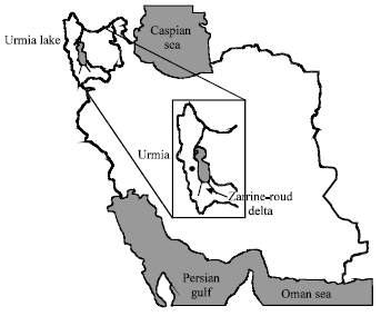
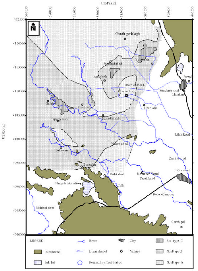
The Urmia Lake and its surrounding plains have been designated as an international park due to its unique character and protected biosphere reserve by United Nations (Daneshgar, 1996; Agassi et al., 1985; Alipour, 2006). Zarrineh-roud delta is a river-lake type delta formed mainly by the sediments of zarine-roud and Simineh-roud entering from the south in to the Urmia Lake. Joining the sediments of two major rivers with a few smaller seasonal streams form a very vast and rich agricultural plain at latitudes of 37°,00'-37°,15' and longitude of 45°,45'-46°,00' (Fig. 1).
This research is a follow up work of a broad scale Pollution survey conducted as a systematic regional monitoring of the Zarine-roud delta originally initiated by joint Iranian government and World Bank supported project with emphasis on the composition and classification of the soil types of the region (Alipour and Farajzadeh, 2000). Understanding soil types in the area could effect the preservation of the area from misuse and pollution as it is required by World Bank and UN.
Soil permeability is an indication of the ease or otherwise with which water moves through the soil. It is determined by the arrangements of soil structural components and is adversely affected by such factors as salt and clay accumulation in soil horizons. The rate of infiltration of water in the soil gives an indication of the rate at which irrigation water should be applied to the soil to prevent surface run-off and drainage loss once saturation point has been reached.
 | |
| Fig. 1: | Position of the study area and Zarrineh-roud delta in northwest of Iran |
These in turn are determined by the soil type it self. Therefore the soil types may be classified by the permeability and infiltration rate.
Land quality and classification has been challenged mainly by chemical and mineralogical bases (Sys et al., 1991). Since chemistry based soil classifications are expensive and time consuming, soil permeability method along with many other usages here is employed for a quick way of physical soil classification in a vast regional scale prior to other methods. Conventional double ring method is used to carry out this concept.
MATERIALS AND METHODS
Forty stations have been selected on the Zarineh-roud plain (Fig. 2) and a well dug to the water table in each station, for monthly water monitoring samples. The same locations are used for soil samples and permeability measurements for the subject of this study. The study was conducted in 2000 and follow up to 2006 (Alipour, 2006).
Permeability of in situ soils is measured by a double ring infiltrometer comprising of inner ring 320 mm and outer ring 550 mm, diameter. The time recorder calibrated to 1, 2, 3, 4, 5, 10, 20, 25, 35 and up to 45 min time intervals. Based on the results infiltration equations were processed for each station. The averaged data, graphically processed by computer programs and infiltration rate calculated based on results for each test point. Based on the results the plain is zoned and its soil classification has been prepared in accordance with the amount of permeability and final infiltration rate.
Land covered by this research have experienced a 10 year dry season. Water table and the water level in the lake have decreased up to 3.5 m in the last decade due to shortage of precipitation and progressive dry climate associated by water exploitation for agricultural needs.
Geomorphology and geology: Zarrineh-roud delta is an almost flat plain, occupies the southern plain of Urmia Salt Lake, at altitude of 1275 m. Geological wise the Urmia Lake is a graben type depression (Eftkharnejad, 1981) consisting couple of seasonal playas and the zarrine-roud delta (Kelts and Shahrabi, 1985, 1997; Shahrabi, 1987). Thirteen rivers flow in the lake but 50% of the water reaching to the lake is passing from this delta plain (Alipour, 2006).
Unlike some other salty rivers, Zarine-roud bears fresh water and all the time washes out the salty water penetrating under this delta and makes a great barrier to the lakes salty water pollution. Mineralogicaly This delta is formed by weathering products of various igneous, metamorphic and sedimentary rocks of all ages from pre-Cambrian to quaternary (Eftkharnejad, 1981) affected the permeability (Fig. 1).
Permeability: Permeability is mostly affected by water content of soils, soil texture and particle mineralogical compositions. Philip (1957a and b). Permeability equations have been calculated and reported by many scientists such as Kostiakov (1932), Horton (1933), Holtan et al. (1975, 1988), Hillel (1988) and Green and Ampt (1911). They over all could be classified in two categories:
| • | Kostiakove equation based on real experimental data. The Kostiakove method usually is used for the measurement of primary permeability rate and is not much effective for the final part of the permeability. Usually the calculated permeability rate is less than measured permeability, hence if t → ∞, the permeability will end to zero which is contradictory to experiments. |
| • | Philip equation based on conceptual data, uniform texture and structure and lack of soil moisture. In this method the permeability rate will never end to zero but could reach to a fixed velocity, which is in harmony with practical experiments. |
In this research due to a decade water deficiency very dry soil and the presence of Na (Alipour, 2006) decreasing the water permeability to the least amount, the Philip equation was employed.
Permeability graph: Using Philip equation with real experimental data (Table 1) infiltration rate and the final infiltration calculated and the graphs for cumulative infiltration and infiltration rates were prepared for each station (Fig. 3) on a logarithmic scale. Based on the Philip equation the permeability is shown by:
| (1) |
which (t) is for cumulative infiltration mm sec-1; Sp is for sorption coefficient and is denoted by ; Áp is for
final infiltration. and t is for duration of waters contact with soil which in term is dependent on primary moisture and the soil hydraulic flow. From the derivation of Eq. 1 the infiltration rate will be:
| (2) |
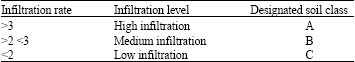
| Table 1: | Three differentiated Infiltration rate and related soil types of zarrineh-roud delta in 40 stations based on the test results |
 | |
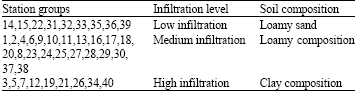
| Table 2: | Three differentiated infiltration range and related soil composition of zarrineh-roud delta in 40 stations based on the test results |
 | |
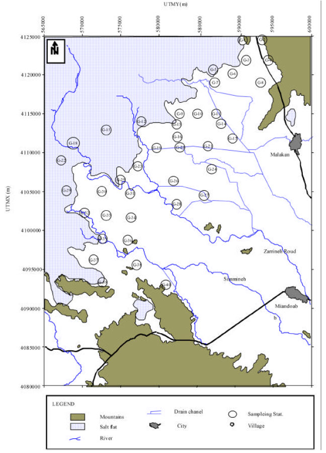 | |
| Fig. 2: | Position of experiment stations in Zarine-roud delta, Urmia Lake |
 | |
| Fig. 3: | Position of soil types classified by permeability measurements in Zarine-roud delta, Urmia Lake |
In this equation the Áp is the final infiltration velocity. According to this equation infiltration decrease with time increase. If t → ∞, infiltration rate, I = Áp hence the final infiltration rate will be the same as hydrolic flow of surface layer in a saturation state or Áp = Ks.
Referring to the mentioned equations and the results compared to a standard final infiltration rate graph soils of the zarrineh-roud plain fall in three categories of infiltration (Table 1) and three different categories of related soil composition (Table 2).
RESULTS AND DISCUSSION
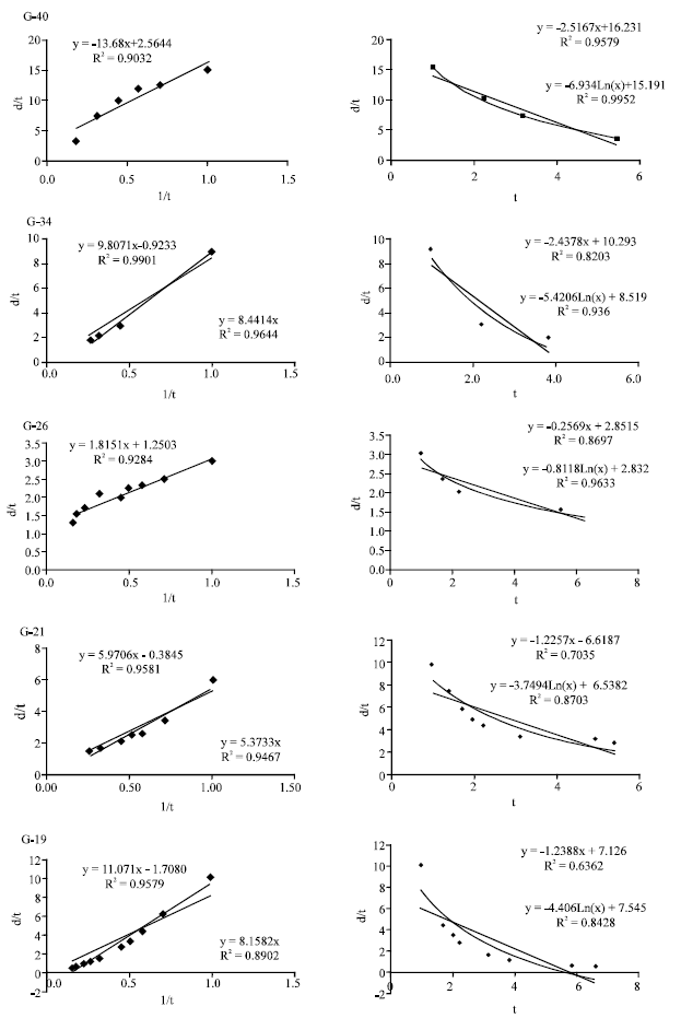
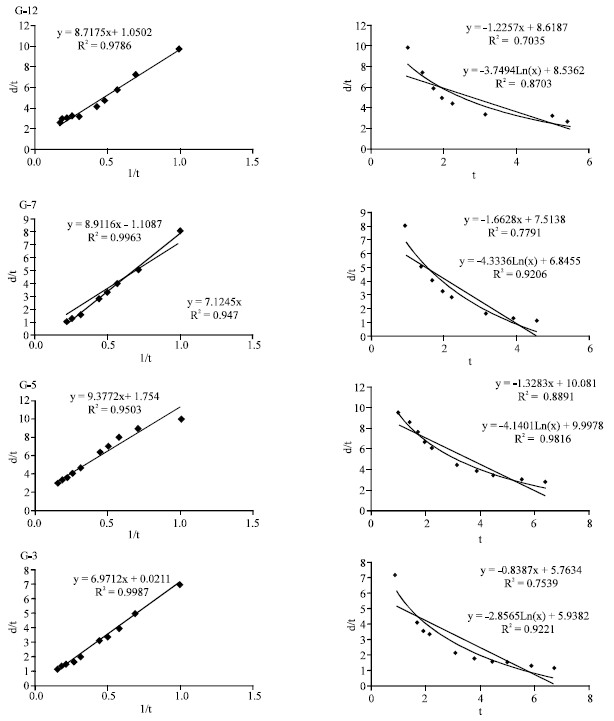
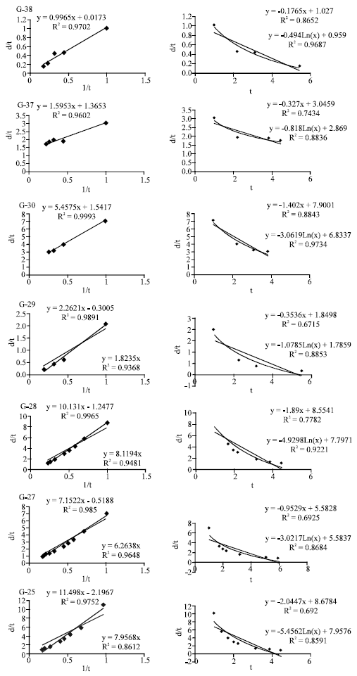
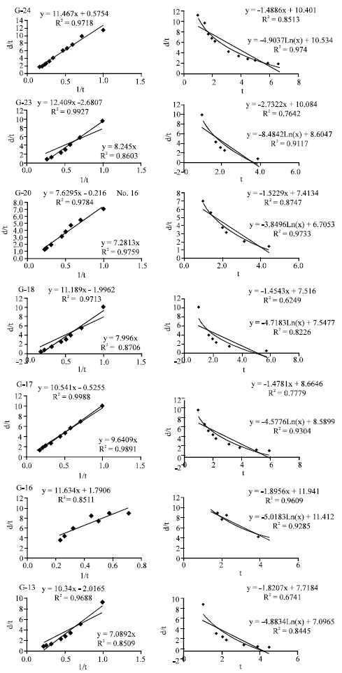
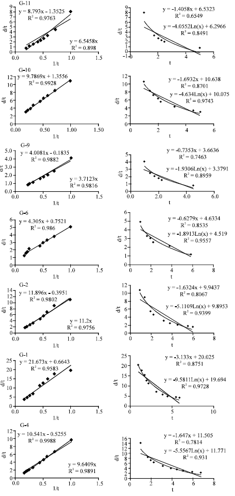
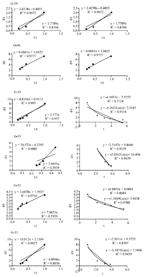
Processing graphically measured data in the field (Table 3) indicates, within three differentiated soil groups (Table 1 and 2) the magnitude of Áp or final infiltration rate (Table 2 and Fig. 4-6) would differentiate the differences between stations and the magnitude of Sp would indicates the ability of each station in transferring the amount of the water among the stations of each group. The high dip of Sp in graphs revealed that infiltration in sandy light textures is very high (Fig. 5), while in stations with low dip Sp which associate with loam and clays, the infiltration is lower and the final infiltration is also low (Fig. 5-6).
Although there are very good harmony between infiltration rate and final infiltration but there are some variation and contradiction results within stations of a group. For example in some stations due to low infiltration, infiltration rate remarkably decreases with time and indicates a negative primary infiltration implying time span has no effect on infiltration (Fig. 6). In some stations with clay composition and the presence of NaCl the infiltration is unexpectedly high witch is indication of large covered cracks in the station. But in stations with clay composition and high NaCl infiltration decrease close to zero very quickly.
| Table 3: | Data used for infiltration rate and cumulative infiltration in measured stations of zarrineh-roud delta |
 | |
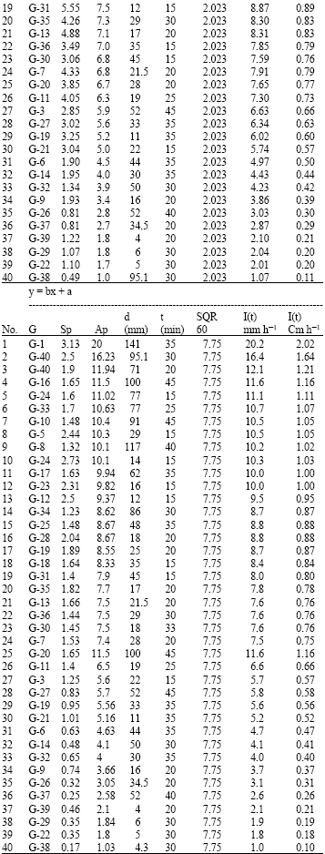 | |
| G = Station number, SP = Sorption, Ap = Final infiltration, T = Cumulative infiltration, I = Infiltration rate | |
 | |
 | |
| Fig. 4: | Final infiltration and cumulative infiltration rates for each experimental station of loamy sand type soil (type A) |
Results indicate stations with very low or absence of soil moisture, have a higher primary infiltration. All these differences are produced by site effect such as soil texture, mineral composition, local Na increase and the presence of some cracks system.
There are high correlation between linear plot and infiltration rate in soils with homogene texture and structure. Although some variations between stations with varying local characters, permeability is able to classify and differentiate soil types.
 | |
 | |
 | |
| Fig. 5: | Final infiltration and cumulative infiltration rates for each experimental station of loamy type soil (type B) |
 | |
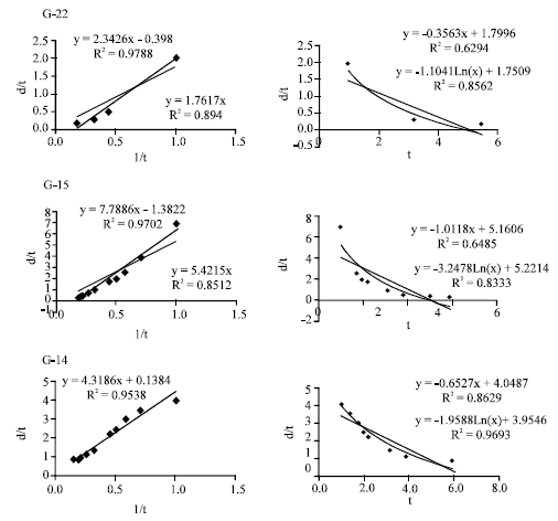 | |
| Fig. 6: | Final infiltration and cumulative infiltration rates for each experimental station of clay type soil (type C) |
CONCLUSIONS
Permeability is able to differentiate soil types and it could be used as a quick and less expensive physical method to identify soil types in regional scale. Double ring permeability measurement method indicate effective enough in primary soil classifications and could result to reduce the use of expensive and time consuming methods. The follow up chemical or other methods may be used in large scale for detailed local soil classification. Enough care must be applied to selection of the sites for the measurements, since the presence of concealed cracks could increase and accelerate infiltration rate not related to soil texture and composition or local compacted clay and higher NaCl can prevent infiltration rate and cumulative infiltration dramatically different from neighboring stations. Such outliers must be considered before final data processing.
Based on this criteria the soils of the research area clearly was divided in three categories, named types A, B and C .
Type A: Mostly is formed in northern part forming the main delta of zarrineh-roud and in the neighboring plains.
Permeability here is high and the soil here is in accordance with loamy sand type soil in the area. High fertile soil is a character of this type.
Type B: Is dominant in the north and northwest part of the zarrineh-roud stream bed with intermediate permeability and the soil here is in accordance with loamy soil type.
Type C: This soil type is developed as individual islands among the types A and B. Its permeability is lower compared to the others and the soil here is in accordance with clay soil types.
Soil types A and B have occupies over 90% of the area but C type is regionally undeveloped due to geological formation unsusceptible to permeability.
REFERENCES
- Alipour, S., 2006. Hydrogeochemistry of seasonal variation of Urmia salt lake, Iran. J. Saline Syst., 2: 9-9.
Direct Link - Green, W.H. and G.A. Ampt, 1911. Studies on soil physics. J. Agric. Sci., 4: 1-24.
CrossRefDirect Link - Philip, J.R., 1957. The theory of infiltration, I. The infiltration equation and its solution. Soil Sci., 83: 345-358.
Direct Link