
Kamran Adeli
Department of Forestry, Faculty of Natural Resources, University of Mazandaran, P.O. Box 737, Badeleh, Sari, Iran
Asghar Fallah
Department of Forestry, Faculty of Natural Resources, University of Mazandaran, P.O. Box 737, Badeleh, Sari, Iran
Yahya Kooch
Department of Forestry, Faculty of Natural Resources, University of Mazandaran, P.O. Box 737, Badeleh, Sari, Iran
Pakistan Journal of Biological Sciences
Year: 2008 | Volume: 11 | Issue: 1 | Page No.: 103-107


ABSTRACT
In order to make the sampling procedure more efficient and more accurate to study the tree species richness and canopy cover, the appropriate plot size was calculated in the this study. The sampling was carried out using 48 four-hectare plots, each with 13 sub-plots of different plot sizes and 7 one-hectare plots, each with 7 sub-plots. The result of this study showed that 300 ARE plot size was determined as the best area for 1-5% density class, 125 ARE plots for 5-10% class, 150 ARE for 10-25% class, 100 ARE for 25-50% class and 75 ARE plot size to sample >50% density class, in 95% confidence level. Consequently, using 100 ARE sampling plots is suggested for all density classes in central Zagros forests.
PDF Abstract XML References Citation
How to cite this article
Kamran Adeli, Asghar Fallah and Yahya Kooch, 2008. An Appropriate Plot Area for Analyzing Canopy Cover and Tree Species Richness in Zagros Forests. Pakistan Journal of Biological Sciences, 11: 103-107.
DOI: 10.3923/pjbs.2008.103.107
URL: https://scialert.net/abstract/?doi=pjbs.2008.103.107
DOI: 10.3923/pjbs.2008.103.107
URL: https://scialert.net/abstract/?doi=pjbs.2008.103.107
INTRODUCTION
Zagros forests have 5.05 million ha-1 area covering northwest to south of Iran. These forests area in above 650-2200 m sea level with mean precipitation of 350-1000 mm. The dominant species are Quercus persica, Pistacia atlantica, Acer monspessulanum and Amygdalus lycioides (Anonymous, 2002). Pay attention to disturbing of this forests in last years, its structures are disturbed and as coppice forests. Forest settlers and native peoples in these forests are components of this ecosystem. For achievement to forest structure, quantity and quality characteristics and other parameters using different methods of sampling are common.
In zagros forests using of sampling methods as sample plots (fix or variable, regarding to forest conditions) and linear (transect) for inventory of canopy cover. Richness (especially, for woody plant) is one of the important factors in disturbed forests (as zagros forests). Plant biological richness includes richness, diversity, population`s structure, plant distribution algorithm (Parthasarathy, 1997). Biological richness is adaptative capacity of forest ecosystems with their environments (Burianek, 1996).
In central zagros forests were used of plots with different area in operation works. Plots with 100 ARE area and square form are being used in Kakareza, Shol Abad and Ghleh Gol regions in Lorestan, west of Iran (Anonymous, 2004a). Forestry group of Lorestan university used circle plots of 10, 12, 15 ARE area in forest management plan of Chekriz in Lorestan Kakareza region (Anonymous, 2004b). The other research in north of Fars province (South of Iran) used square plots of 100, 200, 400 ARE area for vegetation mapping (Anonymous, 2004a).
Salehpoor (1990) had introduced use of satellite images, aerial photographs and field sampling as the best inventory method in Iran. Porhashemi (2003) used plots with 12 ARE, 10, 1 m areas to study forest structure, generation and vegetation in Doveiseh forests in Kurdistan province (west of Iran).
Zobeiry (2000) proposed plots with 10-15 ARE area for coppice forests of Iran west and 10-20 ARE area for high forests of Quercus persica as the best area. Saber (1993) used circle plots of 10 ARE area and inventory network of 150x400 m area with random-systematic method for calculation of canopy cover area, canopy cover volume (for produce of seed), browse volume (for feed of livestock) in protective forests of zagros south (Taheri, 1994).
Fallah (2000) in his study used square plots under selective method. He used plots of 50 ARE area for investigating forest structure (with number and volume ha-1 characteristics) and 100 ARE area with adding other factors. Kerpel (1982), used plots of 0.5-1 ha-1 area for study of growth and stand structure changes in Slovaki natural forest. Sample size was 3-6 plots regarding to stand conditions, species combination and their structure characteristics.
For study of forest structure and stand tree combination in national park of Harbey Kentin in Vietnam had used of plots 1 ha-1 area. Also, plots with 50x20 m area with rectangular form were used for design of vertical and horizontal structure of forest (Kerkhove et al., 1993). Many researches were performed to determine the best inventory network dimensions for Iranian forests. Taheri (1994), selected 200x100 m inventory network and plots of 50 m areas. Navroodi (1992) had proposed plots of 12 ARE area for forest management plans for the North of Iran.
Many researches were performed in relation to species richness. Parthasarathy (1997) had investigated richness of woody plant with diameter more than 10 cm in plots of 1 ha-1 area in tropical forests. They found that these forests have high richness. Porbabayee (2000), in his study used plots of 0.5 ha-1 areas with lozenge shape for woody plant richness in fagetum type in the north of Iran. Hosseini (2001) in investigating the richness of native needle leave forests in the north of Iran using plots of 2500 m area found that richness of these forests in common and new formulas have reduced with increase of elevation above sea level. But, the changes of biological richness in relation to the changes of plots area performed no researches, up to now. In order to, has investigated tree richness instead bio richness and has analyzed with using of graphs, in this study.
In Zagros forest can not use of complete inventory method (due to expanded areas) and pay attention to performed plans in these forests, using of sampling method with fixed plots is logical. Cost and time are the other important factors in forest inventory and with selection of the best inventory network and appropriate area of plots; it is possible to reduce costs. By reason of, determination the appropriate plot area for investigation of canopy cover, richness, species frequency in Zagros forests are the purpose of this study.
MATERIALS AND METHODS
Study area: Study area is located on northern part of Khuzestan province (that is component of Zagros forests ecosystem) between 3628000 to 3654000 longitude and 232000 to 294000 latitude (UTM unit) and 832-1845 m above sea level. Mean annual precipitation is 540 m (Anonymous, 2004c). The dominant forest species in region are Quercus persica, Pistacia atlantica, Acer monspessulanum and Amygdalus lycioides. Forest vegetation is variable between 1-83% and in expended areas these forests are degraded. Study area includes Bidrobeh, Shahzadeh Ahmad, Kabotaran and Koh Chavani local usages. This study was performed in the summer of 2006.
Data collections: In mountainous regions using of single-stage sampling method isn`t useful. In this conditions, using of stratification sampling method (Zobeiry, 2002; Namiranian, 2007). In order to, was used of stratification sampling and random-systematically methods, concurrently, in this study. Firstly, on the basis of canopy cover, canopy cover classes include 1-5, 5-10, 10-25 and 25-50%, more than 50% were selected. Number of 5 plots separated for sampling of one stage (stratification) (with slope < 50%) with using of forest walking and aerial photos and in two stage have selected 2x2 km inventory network with plots 4 ha-1 area for the first four classes and plots 1 ha-1 area for five class (Anonymous, 2004a).
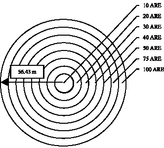
Circle plots was used (that has the least circumference factor), as it has recommended for inventory of forests in the west of Iran (Zobeiry, 2000). species name, canopy cover area, distance tree to center, height of region, slope, aspect, effective factors on degradation, forest type were recorded in every plots. For achievement to tree richness changes and appropriate plot area the releve method was used. Radius of every plots was calculated and then distance of each tree from plot center (using GPS), number of trees and canopy cover area were recorded in plots 10, 20, 30, 40, 50, 75, 100, 125, 150, 200, 250, 300 and 400 ARE areas, separately (Fig. 1, 2) and was calculated, extremely. For determination
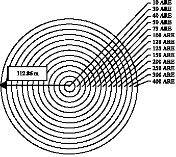 | |
| Fig 1: | Uniform plots and permissible radius for trees inventory (112.86 m in plot 400 ARE area) in 1-5, 5-10, 10-25 and 25-50% canopy cover classes |
 | ||
|
of the appropriate plot area in west forests and to show graphs of tree richness changes, was used of canopy cover 400 ARE on the ground of basis canopy cover and was compared with this area the other areas. Extremely, 48 plots of 4 ha-1 area and 7 plots of 1 ha-1 were recorded (18 plot in 1-5% class, 11 plot in 5-10 class, 10 plot in 10-25 class, 9 plot in 25-50 class, 7 plots in >50% class). Statistical analysis was done in SAS software program in a simple variance design and SNK test was performed for means comparison.
RESULTS
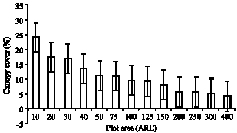
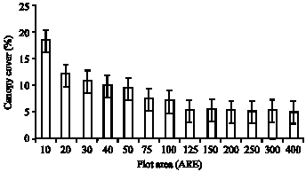
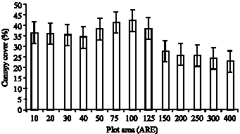
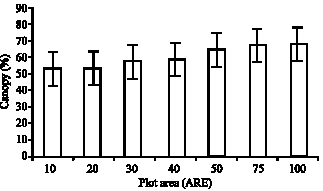
The least plots area for type map, canopy cover classes and investigation zagros forests structure was calculated with analysis collection of data. In 1-5% canopy cover class were insignificant differences between plots 300 ARE area with plots 400 ARE area (Fig. 3). Thus, canopy cover (%) in this area has show actual area of forest in 1-5% class. For 5-10, 10-25, 25-50 and >50% canopy cover classes were calculated 125, 150, 100 and 75 ARE areas, respectively (in 95% confidence level) (Table 1, Fig. 4-7).
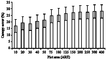
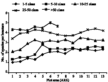
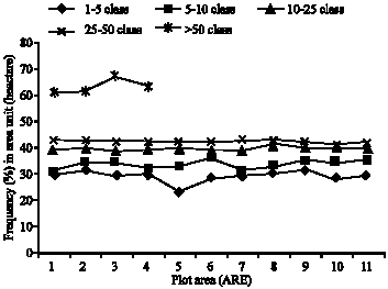
Analysis of tree species richness relation with increase of area has showed that in 1-5% class, 150 ARE area to after, increase trend of tree richness is fixing, almost (Fig. 8). Trend of frequency increase after to 125 ARE area is fixing, also (Fig. 9). In 5-10% class, increase trend of tree richness is extensive to 50 ARE and the other areas increase trend is monotonous, almost (Fig. 8). Total frequency of existent species in this class to 50 ARE area is climbing and the other areas has similar
 | ||
|
 | ||
|
 | ||
|
trend, also (Fig. 9). In 10-25% class, tree richness has increase trend to 30 ARE area and thereafter is following of similar trend (Fig. 8). Total frequency of trees in this class to 40 ARE area is increase trend and thereafter has irregular trend (Fig. 9).
In 25-50% class, tree richness changes is following of irregular trend and the most of this increase is visible in 30, 40 and 200 ARE areas (Fig. 8), Changes of species frequency are following of regular trend and number 41 in hectare is fixing, mostly (Fig. 7). In more than 50% class, increase of tree richness is climbing and tree richness is increasing with increase of area (Fig. 8). Frequency of
| ||
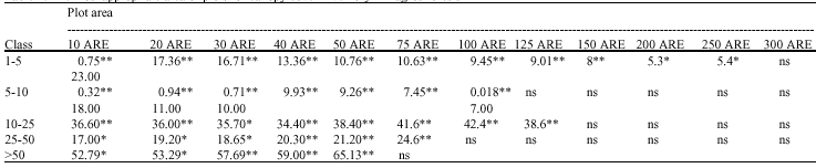 | ||
| * = Significant at the 0.05 F-probability level, ** = Significant at the 0.01 F-probability level, ns = no significant |
 | ||
|
 | ||
|
 | ||
|
 | ||
|
species in this class is increasing trend that the most of it, is visible in 50 ARE area (Fig. 9).
DISCUSSION
Pay attention to disturbed conditions of Zagros forests and spot form of trees distribution in low classes of canopy cover and on the basis obtained results, using of plots with more than 100 ARE area is appropriate and it is similar to plots that is using by forests and rangelands organization in Lorestan (Anonymous, 2004b) and Fars (Saber, 1993) provinces. But it is unlike with plots that were used by Zobeiry (2000), Porhashemi (2003), Saber (2003) and Anonymous (2004b). In according to obtained results for 1-5, 5-10, 10-25 and 25-50% canopy cover classes, plots 300, 125, 150 and 100 ARE areas is appropriate, respectively. In order to harmony with inventory of forest total, plots 200 ARE area for canopy cover (<50%) is recommend, extremely.
Results of this study showed that for canopy cover class more than 50% plots of 75 ARE areas are appropriate, this result confirm Kerkhove et al. (1993), Fallah (2000) and Kerpel (1982) researches in forests with condensed canopy cover. Tree richness in 1-5 canopy cover class has extensive climbing trend to 50 ARE area. This climbing trend is visible in 5-10, 10-25 and 25-50 canopy cover classes to 50 ARE, 30 ARE, 30 and 40 ARE areas, respectively.
Therefore, tree species richness is increasing with increase of cover in central Zagros forests. This subject is trust in relation with species frequency and with increase of canopy cover, species frequency in area unit is increasing. Climbing trend is visible in canopy cover class more than 50% similar to the other classes, also. Therefore, with increase of canopy cover, mentioned information is available in small areas. Pay attention to obtained results of this study is proposed plots 75 ARE and 40 ARE, for determination of tree richness and frequency in <50% and >50% cover classes, respectively. This result is similar to researches result of Parthasarathy (1997), Porbabayee (2000) and Hosseini (2001). Consequently, using 100 ARE area sampling plots is suggested for all density classes in central Zagros forests, pay attention to results of determination plots area for tree species richness and canopy cover in different classes of canopy cover in central zagros forests and in order to saving of time, also
ACKNOWLEDGMENTS
The authors would like to acknowledge Mr. Amir Ahmadi, Mr. Hasanvand, Mr. Kamari and Mr. Ziar for technical supports and throughout the course of this project.
REFERENCES
- Burianek, V., 1996. The Biodiversity and Forest Management in the Czech Republic. In: Assessment of Biodiversity for Improved Forest Planning, Bachmann, P., M. Kohl and R. Paivinen (Eds.). Klwer Academic Publisher, The Netherlands, pp: 405-409.
Direct Link - Vandekerkhove, K., R. de Wulf and N.N. Chinh, 1993. Dendrological composition and forest structure in Nam Bai Cat Tien national park, Vietnam. Silva Gandavensis, 58: 41-84.
Direct Link