
Omar. A. Al-Harbi
Natural Resources and Environment Research Institute (NRERI), King Abdulaziz City for Sciences and Technology (KACST), P.O. Box 6086 Riyadh 11442, Kingdom of Saudi Arabia
Ghulam Hussain
Natural Resources and Environment Research Institute (NRERI), King Abdulaziz City for Sciences and Technology (KACST), P.O. Box 6086 Riyadh 11442, Kingdom of Saudi Arabia
M. Mujtaba Khan
Natural Resources and Environment Research Institute (NRERI), King Abdulaziz City for Sciences and Technology (KACST), P.O. Box 6086 Riyadh 11442, Kingdom of Saudi Arabia
Mohammaed A. Moallim
Natural Resources and Environment Research Institute (NRERI), King Abdulaziz City for Sciences and Technology (KACST), P.O. Box 6086 Riyadh 11442, Kingdom of Saudi Arabia
Ibrahim A. Al-Sagaby
Natural Resources and Environment Research Institute (NRERI), King Abdulaziz City for Sciences and Technology (KACST), P.O. Box 6086 Riyadh 11442, Kingdom of Saudi Arabia
Pakistan Journal of Biological Sciences
Year: 2006 | Volume: 9 | Issue: 2 | Page No.: 260-269


ABSTRACT
The present study was conducted to determine groundwater chemistry, ascertain quality of water for various uses (domestic and agriculture) and define recharge sources of environmental isotopes in Wadi Malal, Al-Madinah Al-Munawarah, Saudi Arabia. Evaluation of water quality revealed that salinity and nitrate concentration are much higher than the established standards for various uses (so to say: irrigation and drinking etc.). Generally, the groundwater has been salinized by the equilibrium of infiltrated rainwater with slight soluble minerals in the regolith and evapoconcentration of groundwater that has been used for irrigation. Well waters in Wadi Malal along its flow path are too saline and the nitrate levels are too high to be used as drinking water. The salinity and sodicity levels in about 80% of the surveyed well waters are sufficiently high, when used for irrigation, to pose constraints on soil, crop and water management. Based on the concentration of the environmental isotopes (Deuterium and Oxygen-18) coupled with different ratios of NO3/Cl and HCO3/Cl, the primary source of the groundwater is rainfall that has occurred during the last 100-200 years with slight fractionation process in the water system.
PDF Abstract XML References Citation
How to cite this article
Omar. A. Al-Harbi, Ghulam Hussain, M. Mujtaba Khan, Mohammaed A. Moallim and Ibrahim A. Al-Sagaby, 2006. Evaluation of Groundwater Quality and its Recharge by Isotopes and Solute Chemistry in Wadi Malal, Al-Madinah Al-Munawarah, Saudi Arabia. Pakistan Journal of Biological Sciences, 9: 260-269.
DOI: 10.3923/pjbs.2006.260.269
URL: https://scialert.net/abstract/?doi=pjbs.2006.260.269
DOI: 10.3923/pjbs.2006.260.269
URL: https://scialert.net/abstract/?doi=pjbs.2006.260.269
INTRODUCTION
Evaluation of groundwater quantity and quality is essential for the development of civilization and to establish database for planning future water resources development strategies. In Saudi Arabia, water resources are limited, non-renewable and vary from region to region. Al-Madinah Al-Munawarah is one of the various potential water bearing regions and located in north-northwest of Saudi Arabia. It is short of major water bearing aquifers due to its natural geography and scarcity of rainfall, which is mainly surrounded by crystalline rocks. There are many wadis in the region. The most prominent wadi is known as wadi Malal, located about 60 km west, north-west of Al-Madinah Al-Munawarah, where quantity and quality of water is very poor and the sedimentary aquifers are scarce except few alluvial beds. Precipitation is very small, unpredictable and long dry periods are common with average rainfall of about 100 mm in wadi Malal.
Previous studies have been conducted on the geophysical, hydrogeological and water quality aspects in wadi Malal in the Al-Madinah Al-Munawarah area (Adams, 1981; Bayumi, 1992; Italconsult, 1979; Bokhari, 1988; Bokhari and Khan, 1992; Bokhari, 1993; Al-Harbi et al., 1998). Only two of these studies identified the water quality of wadi Malal as being saline (Bokhari and Khan, 1992; Al-Harbi et al., 1998). No comprehensive studies have been conducted on the chemistry of rock-water interactions, which can influence the composition of groundwater. These interactions may explain why the wadi beds and groundwater are saline. Besides many studies were conducted in Saudi Arabia on groundwater quality in Al-Qaseem Region (Faruq, et al. 1996), Al-Ahsa Oasis Eastern Province (Hussain and Sadiq, 1991), Saudi groundwater chemistry (Mee, 1983; Allael-Din, et al, 1993) and Wadi Al-Yamaniyah (Bazuhair and Alkaff, 1989).
The western part of the Arabian Shield consists of Precambrian rocks, which were folded, metamorphosed, granitized and intruded during several tectonic phases prior to the Cambrian. In Al-Madinah Al-Munawarah region, rocks of upper Proterozoic age represent two main groups separated by a slight angular unconformity i.e., Alys group and the overlying Furayh group (Fig. 1). The Alys group consists of intermediate mafic volcanic rocks, epiclastic volcanic rocks and tuff with numerous intercalation of silicic lava.
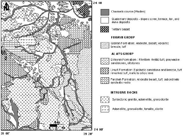 | |
| Fig. 1: | Geological map of the study area (Pellaton, 1981) |
The Furayh group, being an andesitic-basaltic formation, shows sporadic development of conglomerate and sandstone at its base. Non-volcanic terrigenous sedimentary rocks characterize the upper part of the group (Pellaton, 1981).
Wadi Malal consists of alluvial deposits, belonging to the Quaternary period, which constitutes the principal groundwater aquifer of the wadi. These deposits are gravel, sand and clay that follow the present day drainage pattern. Generally, the wadi sediments contain sand, sticky and soft clays followed by heterogeneous nature of rock-fragments (Talus). The sand and clay particles are deposited accordingly to the present day drainage pattern. Occasional presence of pebbles and gravel in the wadi sediment is the result of recent erosion of the Tertiary and Quaternary basalt. The main objectives of this study were to evaluate groundwater chemistry in wadi Malal, quantify hydrogeochemical evolution, ascertain the quality of water for domestic and agriculture consumption and to define the recharge sources by environmental isotopes.
MATERIALS AND METHODS
Description of wadi malal: Wadi Malal catchment area, extending in north-south direction, is located in the western part of the Arabian Shield and lies between latitude 24±00’ and 24±40’ N longitude 39± and 39±20’ E (Fig. 2). Besides the main wadi water stream, there are other small tributaries which supply additional rainwater to the wadi. The additional volume of water entering the wadi has not been estimated so far which might have influenced composition of water in the main wadi stream (Al-Harbi et al., 1998).
Water sample collection: Twenty three water samples were collected from the operational wells being used by the inhabitants of wadi Malal for different purposes during 1999-2000. The distribution of water wells in wadi Malal is presented in Fig. 3. The water samples were collected in sterilized plastic bottles, sealed and stored in an ice chest to avoid any chemical action before analysis. Water quality parameters such as pH, temperature and electric conductivity were measured in the field by a portable instrument called Electrochemistry of CIBA-CORNING Company.
Major cations/anions in water were determined by following the standard methods (United States Department of Agriculture, 1954). Different ions such as Calcium (Ca+2 ) and magnesium (Mg+2) were measured by titration method, Na+ and K+ by flame photometer, Cl– by Titration with Silver nitrate (4500-Cl-Argentometry Method, 1998), SO4–2 by Turbidity (Spectrophotometer), NO3– by colorimteric method and alkalinity, carbonate and bicarbonate by electrometric titration.
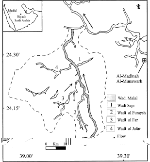 | |
| Fig. 2: | Catchment area of Wadi Malal (Pellaton, 1981) |
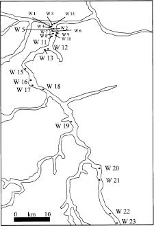 | |
| Fig. 3: | Distribution of water well in Wadi Malal |
Stable isotopes (Deuterium and Oxygen-18 (Coplen, 1994; Coplen et al., 1991) were analyzed at the Central Laboratories of Water Authorities, Ministry of Water and Irrigation, Amman, Jordan. Hydrowin program (Lukas, 1993) was used for action\anion balance and for hydrogeochemical. Water quality data collected in June 1996 (Al-Harbi et al., 1998) was utilized to compare the salinity changes.
The Predicted soil salinity (ECe, dS m–1), adjusted sodium adsorption ratio (adj.SAR), Adjusted Na Ratio (adj. RNa) and Exchangeable Sodium Percentage (ESP) were calculated from the analytical data. The predicted soil salinity (ECe, dS m–1) expected after several years of irrigation with water of salinity of ECiw was calculated (Ayers and Westcot, 1985). The equation used was.
| (1) |
Where:
Ece is the predicted soil salinity and ECiw is the irrigation water salinity (dS m–1). X is the concentration factor found by using crop water use pattern of 40-30-20-10. Which means the crop will get 40% of its ET demand from the upper quarter of root zone, 30% from the next quarter, 20% from next quarter and 10% from the lowest quarter. Crop water use will increase the concentration of the soil water that drains into the next quarter (ECsw) of the root zone. The values of concentration factor are given in Table 1 (Ayers and Westcot, 1985).
• | The Sodium Adsorption Ratio (SAR) was calculated as below: |
| (2) |
• | The Adjusted Sodium Adsorption Ratio (adj.SAR) was calculated (Ayers and Westcot, 1985). |
| (3) |
Where, SARiw is sodium adsorption ratio of the irrigation water as calculated by the normal SAR equation and pHc is a theoretical calculated pH of irrigation water when in contact with lime and in equilibrium with soil CO2.
| Table 1: | Concentration factors (X) for predicting soil salinity (ECe) from irrigation water salinity (ECw) and the Leaching Fraction (LF) |
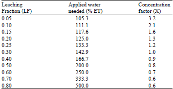 | |
| Source. Ayers and Westcot (1985) | |
| Table 2: | Data for calculating pHc |
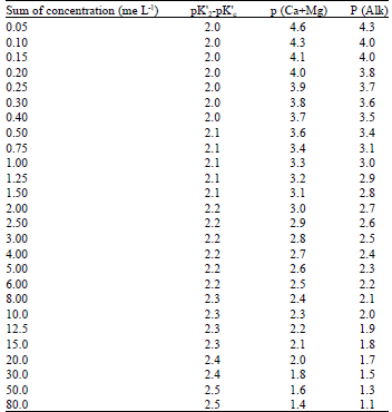 | |
| (Source: Ayers and Westcot, 1976) | |
pHc = (pK’2 - pK’c) + P (Ca + Mg) + P (Alk)
Where, P (Ca + Mg) and P (Alk) are negative logarithms of the molar concentration of Ca+ Mg and titrable CO3 + HCO3, respectively. The pK2’ and pK’c are the negative logarithms of the second dissociation constant of H2CO3 and solubility product of CaCO3, respectively. Positive values indicate that CaCO3 should precipitate and negative values indicate that water will dissolve CaCO3. The data for calculating pHc is given in Table 2.
• | The adjusted sodium adsorption ratio (adj. RNa) was calculated (Suarez, 1981) using the following equation. |
| (4) |
Where, all concentrations in meq L–1, Cax represent concentration after counting for HCO3 of the irrigation waters.
The exchangeable sodium% (ESP) was determined as:
| (5) |
Where, SAR is the SAR of the soil solution resulting from irrigation with spring waters. The irrigation waters were classified according to the prescribed water classification scheme (Ayers and Westcot, 1985).
Where, (pK’2 - pK’c) is obtained by using the sum of Ca + Mg + Na of irrigation water in me L–1 and P (Alk) is obtained by using the sum of CO3 + HCO3 of irrigation water in me L–1.
RESULTS AND DISCUSSION
Salient features: The width of the wadi is very small and varies from 300-2000 m with an average width of about 800 m. The depth of the wells ranges between 51 m (up stream) and 109 m (down stream). The distribution of well is not uniform in the whole wadi being more in the north than the south side (Fig. 2). Therefore, the uneven distribution wells does not allow to present clear picture of the groundwater salinity and the chemistry evolution of the shallow alluvial aquifer except along the narrow path of the wadi. Additionally, most of the wells are drilled with low quality design and the chance of water contamination is quite possible. The main contaminant in these groundwaters could be due to leaching losses of nitrate (NO3) from the irrigation field along the path of Wadi.
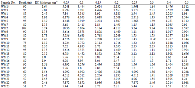
Chemistry of groundwater: The ranges for different water quality parameters were EC, 1.13-3.24 dS m–1; Total dissolved solids (TDS), 732-2108 mg L–1; sodium adsorption ratio (SAR), 1.70-6.38; Ca/Mg ratio, 2.06-4.60; and Cl/SO4 ratio, 1.06-3.40 (Table 3). Generally, sodium (Na) was the most abundant cation followed by Ca and Mg in descending order. Chloride was the most abundant anion followed by HCO3 and SO4 in descending order except well No. 1, 2 and 3 where, SO4 was the dominant anion than Cl and HCO3. The high level of SO4 in these well waters could be due to aquifer geology which is probably dominant by sulfate bearing minerals. The NO3 concentration ranged between 38-323 mg L–1 in different well waters and is quite high than the recommended level of 30 mg L–1 in drinking water according to WHO (1984).
The increase in TDS with distance down stream is not a continually increasing function, but rather a function that changes abruptly at the end of wadi and might be concordant with the direction of groundwater flow. TDS oscillation was observed in the whole wadi especially in the middle part of wadi which could be due to additional supply of fresh water from some other major tributaries. The Na/Ca ratio of well waters ranged between 55:45 in the middle part of the wadi aquifer. This change in water salinity pattern could be due to water intrusion or interaction between wadi Malal and other tributaries from the surrounding wadis due to natural sub-surface drainage.
| Table 3: | Chemical composition of well water |
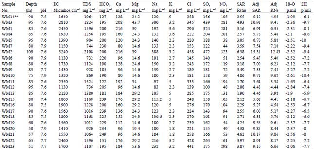 | |
** The sequence in numbering of this table is arranged on the bases of distance from the upper stream of the Wadi Malal (Fig. 3) | |
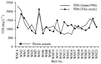 | |
| Fig. 4: | Comparison of water quality of groundwater in Wadi Malal |
Previous water quality assessment revealed that the average TDS were 1283, 1148 and 1324 mg L–1 for upstream, middle stream and downstream, respectively (Al-Harbi et al., 1998). Whereas, the average TDS for the whole wadi were 1252 mg L–1. A temporal comparison of water salinity showed that the average total dissolved solids in 1996 (1252 mg L–1) were higher than this study (1176 mg L–1) (Fig. 4). This salinity oscillation with time could be attributed to water-rock interaction, total volume of water available and the magnitude of replenishment to the water bearing aquifer of wadi.
On the basis of water classification (Freeze and Cherry, 1979), 30% of the wells produced fresh water (TDS ranging from 732-928 mg L–1) and 70% produced saline water (TDS ranging from 1012-2108 mg L–1).
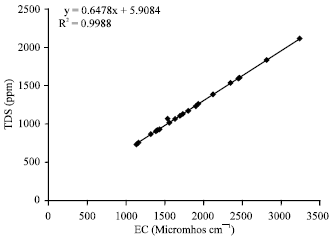 | |
| Fig. 5: | Relationship between EC and TDS of groundwater of Wadi Malal |
Although majority of the well waters are dominated by high salinity with respect to drinking water quality criteria but these well waters can be utilized for some beneficial purposes other than drinking.
Relationship between EC, TDS and SAR of waters: Figure 5 reveals a strong relationship between EC (dS m–1) and TDS (mg L–1) of water [correlation coefficient (r) = 0.999]. The regression analysis showed a poor correlation between EC vs SAR, Adj. SAR and adj. RNa with r values of 0.110, 0.089 and 0.189, respectively (Fig. 6). Because, the SAR of water changes with the square root of increase in salt concentration and also depends on the proportion of different salt ions in the water of a particular aquifer.
| Table 4: | Predicted values of soil salinity from well water salinity in Wadi Malal |
 | |
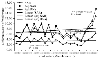 | |
| Fig. 6: | Relationship between EC and SAR, adj. SAR and adj. RNa of well waters |
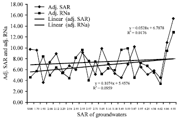 | |
| Fig. 7: | Relationship between SAR vs adj. SAR and adj. RNa |
Effect of water quality on soil properties
Soil salinity: Salts are added to soils through irrigation and the magnitude of salt build up depends on total water salinity, water composition, leaching requirements considered, soil type, soil drainage conditions, climate, management practices and the consumptive use of crops to be grown. The development of soil salinity was predicted from the groundwater salinity for 8 hypothetical leaching fractions (Table 4). Salt buildup decreases with increasing leaching fraction, because more water will be available for leaching salts from the soil profiles beyond root zone. This means that the salinity development will be much faster in soils irrigated with high salinity waters. It also implies that only medium to high salt tolerant crops would be possible in those areas receiving high salinity groundwaters with proper agricultural practices. Furthermore, high salinity irrigation waters could be used for reclamation of salt affected soils. Some successful attempts were made to utilize high saline waters for irrigation under the existing climatic conditions (Fallatah and Hussain, 1988; Al-Tahir et al., 1989). A leaching requirement of 15-20% in excess of crop ET requirements is proposed for safe use of saline groundwaters to control soil salinity within acceptable limits to optimize crop production.
Soil sodicity (SAR): The SAR of groundwaters ranged between 1.70-6.38 with corresponding adj SAR and adj RNa from 3.64-15.31 and 3.38-12.83, respectively (Table 3). The regression analysis showed a high positive correlation between SAR and adj. SAR (r = 0.937) and between SAR and adj RNa, with a correlation coefficient (r) value of 0.959 (Fig. 7). The increase in adj. SAR against a unit increase in SAR of groundwater was almost 2.5 times that of adj. RNa. This implies that adj SAR as calculated here over-predicted sodium hazards in soils.
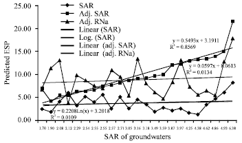 | |
| Fig. 8: | Relationship between SAR and predicted ESP of Soil |
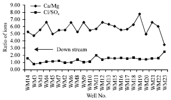 | |
| Fig. 9: | Ion relationship in groundwater of Wadi Malal |
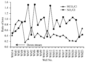 | |
| Fig. 10: | NO3/Cl and HCO3/Cl ratios in groundwater of Wadi Malal |
Similar conclusions were drawn by many researchers (Suarez, 1981; Oster and Rhoades, 1977; Oster and Schroer, 1979). Out of total water samples, 78.3% falls in the category of C3S2 (highly salinity and medium sodicity problem waters) and 21.7% in the category of C4S2 (very high salinity and medium sodium problem waters). However, irrigation with these waters can create soil salinity and sodicity hazards on a long-term basis if certain management practices such as selection of medium to high salt tolerant crops, leaching requirements, adoption of improved irrigation systems and different planting practices are not followed (Maas and Hoffman, 1977). Overall, the data show that the use of chemical composition of groundwaters may not be accurate preposition in predicting the sodicity hazards in soils.
Predicted ESP of soils: The ESP values of soils that would be irrigated with groundwaters were predicted and plotted (Fig. 8). The predicted ESP ranged between 1.25-8.23 (SAR), 4.16-21.54 (adj. SAR) and 3.76-17.84 (adj. RNa). The SAR, adj. SAR and adj. RNa were all significantly correlated with the predicted ESP of soils (r = 0.963, 0.937 and 0.959 for SAR, adj. SAR and adj. RNa, respectively). The ESP predicted from adj. SAR of groundwaters was significantly higher than those predicted from adj. RNa. An ESP greater than 15 indicates sodicity hazards (Ayers and Westcot, 1985; Driscoll, 1989). The predicted values of ESP were lower than 15 for all the well waters except WM2 where it was above than 15 (critical limit for the development of sodicity hazard in soils after irrigation). As such, there would be no immediate sodicity hazards to soils irrigated with these waters. Overestimation of Na hazards by the adj. SAR have been discussed (Suarez, 1981; Oster and Rhoades, 1977; Oster and Schroer, 1979).
Nitrate concentration: The Nitrate (NO3) contents ranged from 38-323 mg L–1 in the groundwater (Table 3). Excess nitrogen in irrigation water causes excessive plant vegetative growth, delayed maturity, or poor quality if the total nitrogen in more than 30 mg L–1. Because some groundwaters can create crop production problems (Ayers and Westcot, 1985). According to WHO (1984), the safe limits for NO3 contents in waters are 45 mg L–1 or less for various uses. These waters can create health hazards (such as nitrate toxicity and physiological disorder) if used without removing high levels of NO3. The high nitrate concentration in well waters may be due to the excessive use of inorganic nitrogen fertilizers by the farmers to obtain higher agricultural production and is contaminating the groundwater aquifer due to deep percolation losses of the applied nitrogen fertilizers.
Geochemical evolution: Mineral precipitation and dissolution, Cl/SO4 (1.06-3.40), Ca/Mg (2.06-4.60) (Fig. 9) and HCO3/Cl (0.25- 0.883) and NO3/Cl (0.118-.544) (Fig. 10) are indicators of groundwater evolution and serve as guidelines to distinguish different water bodies originating from different rock types (Lloyd, 1981). Hydrowin software (Lukas, 1993) was used to determine geochemical evolution of groundwater and processes occurring in the wadi including dissolution and precipitation of the minerals in the system.
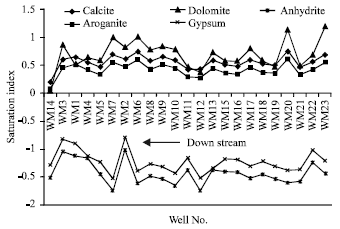 | |
| Fig. 11: | Saturation index of groundwater in Wadi Malal |
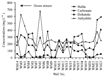 | |
| Fig. 12: | Mineral proportion in groundwater of Wadi Malal |
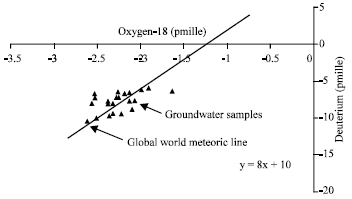 | |
| Fig. 13: | Isotopic composition of groundwater in Wadi Malal |
Along the flow path, Cl/SO4 ratio indicates an increase of chloride ion in the down stream of wadi while Ca/Mg ratio indicates an increase of calcium along the same direction. These increases reveal the dominance of halite and calcite minerals in the catchment area and are the indicators of lithology type. The dissolved minerals in the system are not in the same proportion, except in few wells. The dissolved minerals are calcite, dolomite, aragonite, gypsum and anhydrate (Fig. 11 and 12). The presence of these minerals indicates the nature of lithology of catchment area. Generally, more relevant saturated mineral in most of the study area is dolomite followed by calcite and aragonite while gypsum and anhydrite are in unsaturated state. However, dolomite seems to be near precipitation stage in the aquifer followed by calcite and aragonite. Whereas, other minerals such as gypsum and anhydrite are dissolving in the aquifer. The pattern of mineral distribution and frequencies in the system along the flow path of groundwater is not in steady state but is oscillating. This might be attributed to the contribution of small tributaries entering the main wadi (Fig. 3).
Isotope content and recharge: Freshwater contains relatively positive isotopic correlation of Oxygen-18 and Deuterium that represents recent precipitation while old water contains negative correlation of oxygen-18 and deuterium having smaller slope than the world meteoric line, an indication of old precipitation. This directly identified the groundwater characteristics and enabled the evaluation of recharge through the aquifers besides certain factors, which control the state of isotopes (Mazor, 1991). Usually, the spatial and temporal variations of isotopes indicate the processes, which occur in the system. The deuterium varies from B10.4 to B5.9% with a mean value of -9.33% and oxygen-18 varies from B2.84 to B1.9% with a mean value of -2.00%. As such, groundwater data falls distinctively on the meteoric line indicating that similar climatic regime recharges the aquifer without significant evaporation and suggesting fast infiltration (Fig. 12). These results are supported by Rizk and Alsharhan (Rizk and Alsharhan, 2003) who stated that the stable isotopes (2H and 18O) are highly enriched in the groundwater of the Quaternary Liwa aquifer, suggesting intensive evaporation prior to recharge. This also implies that the aquifer is recharged by recent rainwater without major fractionation process. Although isotopic concentrations for these two stable isotopes are slightly higher in the down stream of wadi, where salinity of groundwater is also relatively high, yet there are no significant variations in the 18O and 2Hä concentrations in the area (Fig. 13). Similarly, Katz (1998) concluded that the water from a sinkhole lake (Lake Barco) with enriched isotopes signature moved downward and laterally beneath the lake and mixed with groundwater. In addition to the above criteria, HCO3 /Cl (0.205-0.883) ratio is an indicator of aquifer recharge. Relatively high bicarbonate and low chloride indicate recent recharges. The ratio of HCO3/Cl from the alluvial water samples tends to be one. This suggests that the age of groundwater in the aquifer is very recent and enough replenishment occurred recently. Similar views were expressed by Al-Bassam (1998) in a study on different sabkha aquifers which states that sabkha groundwaters are influenced by several hydrochemical processes. The most influential of these processes are mixing and ion exchange. Oxidation occurs in the low salinity zone, as O enriched recharge reaches the aquifer through fault planes and fracture zones. Another tracer, which provides information on the rate of water movement on the increase of agricultural use and environmental information, is nitrate (NO3). Also, the pattern of NO3/Cl ratio (Fig. 10) indicates an increasing magnitude towards down stream of wadi. This reveals that the rainfall, which recharged the aquifer, was probably recent due to low concentration of chloride in the down stream water. The recent rainfall has increased the leaching of nitrate through the soil and decreased the concentration of chloride in the profile. High ratio of NO3/Cl in the soil profile and water samples means low chloride and hence represents wetter recharge period.
Evaluation of water quality based on chemistry and isotopes suggested that groundwaters of wadi Malal are fit for agricultural purposes except well No. WM5 and WM7, which can be used for drinking. The SAR varies from 1.7 (minimum) to 6.38 (maximum) with an average value of 3.34. Development of soil salinity and sodicity hazards might be minimum due to very low TDS and SAR of the groundwater in wadi Malal (Ayers and Westcot, 1985). Out of these, 78.3% falls in the category of C3S2 (highly salinity and medium sodicity problem waters) and 21.7% falls in the category of C4S2 (very high salinity and medium sodium problem waters. Relatively high salinity and nitrate (mean value of 128 mg L–1) concentration was observed. Groundwater contamination is possible in some shallow aquifer wells due to high levels of nitrate. Assessment of environmental isotopes (Deuterium and Oxygen-18) and geochemical evolution showed the pattern of recharge conditions and recharge time scale of the alluvial aquifer, which indicated recent recharge with salinity dilution in some parts of the aquifer.
ACKNOWLEDGMENTS
The authors would like to thank King Abdulaziz City for Sciences and Technology (KACST) for financial support and chemical analyses. Appreciation is extended to the Central Laboratories of Water Authorities, Ministry of Water and Irrigation, Jordan for isotope analyses.
REFERENCES
- Al-Tahir, O.A., A.A. Al-Noaim and A.A. Al-Jassim, 1989. The effect of drainage water on nodulation, nitrogen fixation and growth of Faba bean. Biol. Wastes, 29: 63-66.
CrossRef - Allael-Din, M.N., I.M. Madany, A. Al-Tayaran, A.H. Al-Jubair and A. Gomaa, 1993. Quality of water from some well in Saudi Arabia. Water Air Soil Pollut., 66: 135-143.
Direct Link - Coplen, T.B., 1994. Reporting of stable hydrogen, carbon and oxygen isotopes abundance. Pure Applied Chem., 66: 273-276.
Direct Link - Hussain, G. and M. Sadiq, 1991. Metal chemistry of irrigation and drainage waters of Al-Ahsa Oasis of Saudi Arabia and its effects on soil properties. Water Air Soil Pollut., 57-58: 773-783.
CrossRefDirect Link - Maas, E.V. and G.J. Hoffman, 1977. Crop salt tolerance-current assessment. J. Irrig. Drainage Div., 103: 115-134.
Direct Link - Oster, J.D. and F.W. Schroer, 1979. Infiltration as influenced by irrigation water quality. J. Am. Soc. Soil Sci., 43: 444-447.
CrossRefDirect Link - Suarez, D.L., 1981. Relation between pHc and Sodium Adsorption Ratio (SAR) and an alternative method of estimating SAR of soil or drainage waters. Soil Sci. Soc. Am. J., 45: 469-475.
CrossRefDirect Link