
Aydin Ozdemir
Department of Landscape Architecture, Ankara University, Diskapi 06110, Ankara, Turkey
Journal of Applied Sciences
Year: 2007 | Volume: 7 | Issue: 23 | Page No.: 3713-3720


ABSTRACT
This study presents a method for planning the assessment and implementation of an open space system for urban landscapes based on key landscape ecological principles which recognize the importance of spatial configuration and the role of connectivity. The open space network is proposed as a key component of a sustainable urban landscape. The study aims to investigate possible benefits of urban green space networks for more socially integrated urban communities. The research method consists of the site inventory, analysis and synthesis through site documents that include pictures, maps and aerial images. Golbasi Natural Conservation Area in Ankara is the basic material of the study. The proposed strategy is used to develop relationships between the importance of community life and quality as well as the quantity of urban open space networks. Although the proposal is case specific, its aim is to provide an integrated approach to the ecological planning, design and management of urban open spaces to improve the quality of life in contemporary cities.
PDF Abstract XML References Citation
How to cite this article
Aydin Ozdemir, 2007. Urban Sustainability and Open Space Networks. Journal of Applied Sciences, 7: 3713-3720.
DOI: 10.3923/jas.2007.3713.3720
URL: https://scialert.net/abstract/?doi=jas.2007.3713.3720
DOI: 10.3923/jas.2007.3713.3720
URL: https://scialert.net/abstract/?doi=jas.2007.3713.3720
INTRODUCTION
The world is becoming an increasingly urban place. However, urban environments face significant problems: Uneven urban development, creation of economic and social sink areas and environmental decay (Vasconcelos et al., 2007; Li et al., 2005). The massive increase in urbanization and the impact of urban areas on the global environment mean that creating more sustainable urban areas is essential to sustainability. Open space networks are one possible step to create sustainable urban environments (Costanza et al., 1997; Jongman et al., 2004; Opdam et al., 2006; Jongman, 1995; Zhang and Wang, 2006). This study establishes the relationship between urban sustainability and open space networks in a case study. Moreover, the potential of the open spaces for a greater urban sustainability is demonstrated. As a result, it is concluded that open space networks are important planning tools in urban areas. In order to employ this tool, a network assessment method is introduced. This methodology is based on the interpretation of open space values. The proposed methodology is applied to develop an open space network towards a greater urban sustainability for the Golbasi region in Ankara.
The objectives of the study are; to review the literature on ecology and design that relate the protection, linking and design of urban open spaces; to apply this information in the development of an ecological framework for the planning and design of these spaces; to illustrate the utility of the framework through a model of urban green space network; to generalize the potential knowledge for planning and design of urban open spaces.
Making cities sustainable through open space networks: Urban open spaces, which have significant ecological, social and economic functions, are important components of the complex urban ecosystems (Bradley, 1995; Shafer, 1999; Tyrvainen, 2001; Lutz and Bastian, 2002). Urban open spaces, because of their key characteristics such as spatial configuration and multi-functionality, bring to an urban area a wide range of benefits. They are effective areas in modifying the human comfort in the built environment (Kaplan and Kaplan, 1989; Milward and Mostyn, 1989; Wohlwill, 1983). They improve the urban environment, contribute to public health and increase the quality of life of urban citizens (Miller, 1988; Grey, 1996; Teal et al., 1998). They serve as recreational facilities for the urban population; dividing urban land into several forms; preventing environmental problems; connecting nature and urban form and having potentials for urban ecological functions (Condon, 1995). In future, the social and spatial implications of new lifestyles, values, attitudes to nature and sustainability will even lead to higher demands for these spaces (Thompson, 2002). These benefits are reinforced when they are connected in a comprehensive network, linking the main significant areas of natural, ecological, scenic, social and cultural values of an urban area (Ahern, 1991). In this context, these networks are crucial planning tools and can help make progress towards greater urban sustainability (Condon, 1995).
One of the most accurate ways to provide urban green space is to surround the urban environments with a greenbelt. Greenbelt is an open and green area used for recreation, sustainable forestry and controlling and limiting the urban growth (Conine et al., 2004). Satellite towns can be built outside the belt. Another approach is to set up green corridors in urban environments; the greenways. Greenway is interconnected networks of linear green spaces (Linehan et al., 1995; Forman and Godron, 1986; Fabos and Ryan, 2006; Fábos, 2004; Cook, 2000). Some cities have converted abandoned railroad right-of-way and dry creek beds into bicycle, hiking and jogging paths, often called as greenways (Vuilleumier and Prélaz-Droux, 2002; Conine et al., 2004; Toccolini et al., 2006). These approaches can be examples of an open space network. The form and size of the network generally depend on the place that the system is applied. Beyond that, the most important opportunity is the function of the network that sustains the structure, health and the quality of the urban areas.
Defining the open space network components: The environment is a complex web of landscape elements that change and evolve overtime. For Forman and Godron (1986) the landscape is composed of patches, nodes, links and corridors that exist within a dominant background, the landscape matrix. Patches and nodes are non-linear areas and links and corridors are linear arrangements of natural areas (Forman and Godron, 1986; Pickett and White, 1985; Paine and Levin, 1981). A network can be assessed based on a network analysis theory. An important aspect of this theory is the concept of network connectivity, which is a degree to which all nodes in a network are linked. The major aim is to present a theoretical and methodological approach to green network planning that accounts for regional biodiversity and systematizes the selection of green space links (Linehan et al., 1995).
For convenience, all landscapes are separated into four categories based on structural characteristics alone:
Scattered patch landscapes: Examples are suburbia with scattered schoolyards, desert with scattered oases and rangeland with patches and woods. Scattered patch landscape has unique spatial configurations of local ecosystems (Fig. 1). These configurations exert major controls on the levels of slowly changing variables that determine sustainable development.
Network landscapes: These are characterized by prominent intersecting corridors throughout the landscape. The key spatial characters are: Corridor width; connectivity; network circuitry; mesh size; node size and node distribution (Fig. 1).
Interdigitated landscapes: Here, two or more continuous landscape element types are prominent and mesh or interfinger along their common boundary.
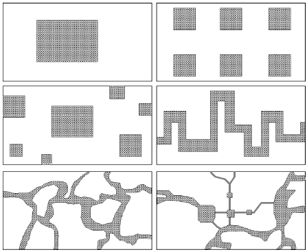 | |
| Fig. 1: | Spatial landscape patterns |
Examples are housing developments along roads interfingering with the unbuilt surroundings and agriculture and forest interdigitating in a ridge and a valley area (Fig. 1).
Check board landscapes: These landscapes have a grid with two or more landscape element types in alternating cells of the grid. Examples are some systematically managed logging patterns and some highly regular agricultural fields with alternating crops (Fig. 1). The regeneration of trees for forest production is often enhanced in a logged check board and boundary related phenomena such as tree blow downs are wide spread (Franklin and Forman, 1987; Gardner et al., 1987).
In summary, the four landscape types exhibit sharply different spatial configuration of local ecosystems. These spatial configurations exert manifold and major regulatory controls on the slow cyclic variables of sustainable environments.
Need for an ecological framework: Sound planning and design of open spaces aids in establishing ecological networks (Cook, 2000, 2002). The needs and expectations of the population can be fulfilled by the variability in the open space types (Chiesura, 2004). An ecological framework that meets the stated objectives but is oriented towards a different environment has been developed by Cook (1991) for an urban ecological network for the city of Phoenix. An underlying assumption of the framework is that some existing landscape elements must be modified to establish an ecological network within an already established urban infrastructure.
The framework includes an ecological planning process (McHarg, 1969; Cook, 1991) and built in ecological design process (Lyle, 1986) and ecological knowledge that are related to the design of natural areas (Smith and Theberge, 1986) and theory and methodology from landscape ecology (Naveh and Liberman, 1984; Forman and Godron, 1986). The result is a framework that includes an assessment of natural and cultural resources and the formation of open space spatial structure (Zhang and Wang, 2006).
Assessment begins with an inventory and description of existing and potential resources. These are classified as landscape elements according to the characteristics relevant to urban open spaces and then assessed for relative ecological worth. These must span several scales, recognizing that ecological functioning is hierarchical but connected between scales. Quality, quantity and location of remnant corridors and patches are then assessed by considering interrelationships with the surrounding urban matrix (Cook, 1991).
MATERIALS AND METHODS
This is a field study, which was conducted in summer 2006, with the research material as the open spaces of Golbasi region. The case study focuses on different open space types in the region. The current condition of the region was investigated, rather looking at the changes of open space system through history. The research method consists of the site inventory, analysis and synthesis through site documents that include pictures, maps and aerial images. Since this study is methodological-based, no detailed analysis on the region is pursued. Findings of this research are important to generate design and planning goals for similar regions.
The present study aims to investigate the effects of open space network development on the spatial characteristics in Golbasi region. Specifically, the objective is to define the types of open space systems in the urban setting. A methodological proposal, which is based on Cook’s (1991) framework, is presented to describe the open space structures in Golbasi region.
Setting: Golbasi nature conservation region: Golbasi, one of the major outer districts of Ankara, is a popular recreational destination with its proximity to major areas of recreation, natural areas and transportation (Fig. 2). The elements that contribute to the amenity of Golbasi region are: its extensive reserves, its low density and its coastline margin along the Mogan Lake. However, as with any modern urban area it faces many environmental problems. In order to assess the network components of the study area, first, the interpretation of landscape in Forman and Godron (1986) is projected. Then, the whole area is assessed for demand of connectivity among open and green spaces.
Over the last 10 years, Golbasi urban area has been continuously enlarged. The developed area has already exceeded by additional development areas, encroaching the vast quantities of agricultural land. These developments mainly consist of satellite towns, private houses and village towns, mainly located at the transition between the inner city and Golbasi district. As a consequence, open and green spaces also decreased which have negative impacts on the services provided by these ecosystems for people. Furthermore, the future population increase in Ankara will pose severe pressure on green spaces. According to principles of landscape ecology, a network assessment process is pursued to purpose a suitable green network system.
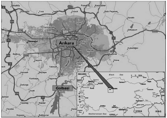 | |
| Fig. 2: | The location of the Golbasi region in Ankara city and Turkey |
Based on the familiarity with the site and previous experiences, a physical network, which connects natural values of the area with the surrounding by using open spaces, is defined. In this process, the network assessment method was used to identify quantified results to propose what kind of open space systems would be eligible to be linked with others.
Although the land is located on the edge of the city, less than 30 min driving distance to the city center, the connection of the area with the existing inner city open spaces has not been well established. There used to be many projects and master planning efforts to make a link to the city center but these were not applied. This study does not aim to develop another plan to make it happen. Rather, the study aims to develop an ecological framework proposal by using the network assessment method.
NETWORK ASSESSMENT PROCESS
The assessment process in the framework is the network assessment; an analysis method that can be used to measure the links in the landscape. A map of existing open spaces and landscape continuity was created for the study area using the current land cover. Based on the evaluation of this map, the potential impact of built areas or infrastructure on landscape continuity was estimated. This was done in several graphic methods.
| Table 1: | Each landscape element is assessed for its present status and potential for providing links according to four criteria listed |
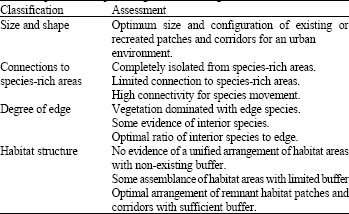 | |
Each landscape element is assessed for its present status and potential in providing links according to the following criteria: landscape element size and shape, connection to species-rich areas, degree of edge and habitat structure (Table 1). Network assessment is undertaken using (Table 1). An inventory of the study sites lead to the identification of several open spaces as shown in Table 2. These open spaces are assessed using table to determine the status for providing link. These results are used to rank and group the open spaces and indicate to provide linkages in the landscapes.
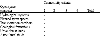
First, a table that lists examples of open spaces in the Golbasi region was developed. These spaces include (in a larger scale); hydrological systems, planned green spaces, transportation corridors, geological formations, urban forest lands and agricultural fields.
| Table 2: | Network assessment: A measurement of links of urban open spaces |
 | |
In the second stage, open space elements were defined by assessing and selecting these spaces in micro scale. These areas include (in a smaller scale); lake sides, urban parks, electric wire connections, Imrahor valley, Ankara greenbelt and farmlands in the area (Fig. 3).
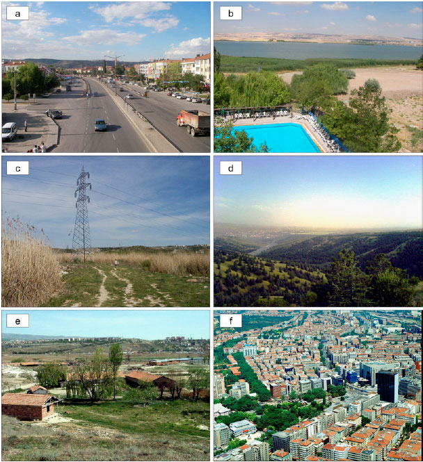 | |
| Fig. 3: | Open space elements in Golbasi region (a) transportation corridor (b) lake side (c) electric wire connections as paths (d) greenbelt (e) urban farmland and (f) populated areas as patches and nodes |
| Table 3: | Selected open space elements in Golbasi Region and results of the network assessment process |
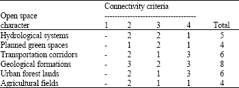 | |
After illustrating open space elements and their potentials in the region, each of them were rated according to the scale system shown in the network assessment table. As an example, electric wire connection paths scored 2 points in the second connectivity criteria because the path has limited connections to species-rich areas. In the third column, the path was rated as 1 point, which characterizes vegetation dominated property with edge species. Lastly, habitat structure was defined as optimal arrangement of remnant habitat patches and corridors with sufficient buffer that scored three (3) points. As seen from the example, the total point of the path element is six, which is one of the second highest points in the Table 3.
RESULTS
In this case, results show that, Imrahor valley is characterized with the highest connectivity. According to visual and natural properties, the valley system create a strong link with other urban open space areas that can be used as a general framework for developing inner city green space networks.
An inventory of the study sites lead to the identification of several open spaces. These open spaces are assessed to determine the status for providing link. These results are used to rank and group the open spaces and indicate to provide linkages in the landscapes. The proposed method allows the development inequalities of particular urban open spaces that promote balanced and sustainable network formations. The results of such assessment may be helpful for similar city authorities in distributing natural resources in a sustainable manner.
This strategy would help to meet the challenges of future urban development in Golbasi region and Ankara city and it is intended to implement step by step. The method should be introduced to the planning departments for their evaluation. The landscape assessment requirements outlined in this technique is quantitative in nature. Some qualitative assessments of open spaces such as the evaluation the people’s perceptions of those spaces would contribute to more understanding of user-environment interactions. However, there are limitations in this method; the method is conceptual and not elaborated in detail. Some investigations such as the selection of the open spaces and establishment of computer aided assessment techniques should be considered. Furthermore, the assessment, planning and management of open space networks must be linked with the network implementations in the wider city scale and must proceed hand in hand with surrounding regional land use planning of Ankara city.
CONCLUSIONS
Much can be done to improve the livability of cities through concern for greenness and through the preservation and introduction of plants and wildlife. Continuity of urban open spaces is a key factor for maintaining a sustainable ecosystem. There is a growing need by planners and designers for tools to assess and maintain connectivity between habitats and to minimize landscape fragmentation. Moreover, open landscape continuity may serve as an indicator for changes in the quality and value of the non-built landscape over time. These features should be qualified by planning and design solutions with open space networks. For site planning and design, open space networks are particularly important, as they constitute a major part of the diversity that is required to make places satisfactory settings for human life.
Urban open spaces are key ingredients in ecologically sensitive regions for sustainability. If the aim is to sustain the ecological diversity through forming networks, we need to assess and define the different types of open spaces and their contribution in the overall system. The ecological design and planning of these networks, which include patches or corridors, should be integrated into the ecological network of urban matrix. By naming their contributions will promote the awareness of their benefits.
As natural areas in urban environments become more fragmented and threatened, using approaches like the ecological framework in landscape planning, design and management might begin to reverse the trend. It is not too late in many cases to begin the healing process and allow nature to begin to play a more important role in the health of cities through ecologically functioning urban open spaces.
By collecting similar results from different open spaces in and around the urban center, researchers would propose a network system that best links the selected open spaces. The findings will help designers/planners to develop their own design ideas based on the quantifiable research results.
REFERENCES
- Chiesura, A., 2004. The role of urban parks for the sustainable city. Landscape Urban Plann., 68: 129-138.
CrossRefDirect Link - Conine, W.N., J.Y. Xiang and D. Whitley, 2004. Planning for multi-purpose greenways in Concord, North Carolina. Landscape Urban Plann., 68: 271-287.
Direct Link - Cook, E.A., 2002. Landscape structure indices for assessing urban ecological networks. Landscape Urban Plann., 58: 269-280.
CrossRef - Fabos, J.G., 2004. Greenway planning in the United States: Its origins and recent case studies. Landscape Urban Plann., 68: 321-342.
CrossRefDirect Link - Fabos, J.G. and R.L. Ryan, 2006. An introduction to greenway planning around the world. Landscape Urban Plann., 76: 1-6.
CrossRefDirect Link - Jongman, R.H.G., 1995. Nature conservation planning in Europe: Developing ecological networks. Landscape Urban Plann., 32: 169-183.
CrossRefDirect Link - Jongman, R.H.G., M. Kulvik and I. Kristiansen, 2004. European ecological networks and greenways. Landscape Urban Plann., 68: 305-319.
CrossRefDirect Link - Li, F., R. Wang, J. Paulussen and X. Liu, 2005. Comprehensive concept planning of urban greening based on ecological principles: A case study in Beijing, China. Landscape Urban Plann., 72: 325-336.
CrossRefDirect Link - Linehan, J., M. Gross and J. Finn, 1995. Greenway planning: Developing a landscape ecological network approach. Landscape Urban Plann., 33: 179-193.
CrossRefDirect Link - Lutz, M. and O. Bastian, 2002. Implementation of landscape planning and nature conservation in the agricultural landscape: A case study from Saxony. Agric. Ecosyst. Environ., 92: 159-170.
CrossRefDirect Link - Opdam, P., E. Steingrover and S. van Rooij, 2006. Ecological networks: A spatial concept for multi-actor planning of sustainable landscapes. Landscape Urban Plann., 75: 322-332.
Direct Link - Shafer, C., 1999. US national park buffer zones: Historical, scientific, social and legal aspects. Environ. Manage., 23: 49-73.
CrossRefDirect Link - Teal, M., C.S. Huang and J. Rodiek, 1998. Open space planning for Travis Country, Austin, Texas: A collaborative design. Landscape Urban Plann., 42: 259-268.
CrossRefDirect Link - Thompson, C.W., 2002. Urban open space in the 21st century. Landscape Urban Planning, 60: 59-72.
Direct Link - Toccolini, A., N. Fumagalli and G. Senes, 2006. Greenways planning in Italy: The Lambro River Valley greenways system. Landscape Urban Plann., 76: 98-111.
CrossRefDirect Link - Tyrvainen, L., 2001. Economic valuation of urban forest benefits in Finland. J. Environ. Manage., 62: 75-92.
CrossRefDirect Link - Vuilleumier, S. and R. Prelaz-Droux, 2002. Map of ecological networks for landscape planning. Landscape Urban Plann., 58: 157-170.
Direct Link - Zhang, L. and H. Wang, 2006. Planning an ecological network of Xiamen Island (China) using landscape metrics and network analysis. Landscape Urban Plann., 78: 449-456.
Direct Link