
F. T. Mugabe
Department of Land and Water Resources Management,
Midlands State University, P.O. Box 9055, Gweru, Zimbabwe
Journal of Agronomy
Year: 2004 | Volume: 3 | Issue: 3 | Page No.: 188-190


ABSTRACT
Rainfall is low and erratic in the semi-arid areas such that crop production fails in most years. Water harvesting techniques have been observed to harvest and concentrate rainwater and this results in increased soil moisture and yields. Most of this study has been done on in-field water harvesting techniques while there has not been any similar work to evaluate the benefits of in-contour water harvesting techniques on soil moisture and crop yields. Soil water storage was monitored above and below an infiltration pit over a season to identify differences in soil water storage of access tubes that are at different distances both above and below an infiltration pit. Soil moisture storage in the access tubes decreased from the infiltration pit both down slope and up slope. The difference in soil moisture between these access tubes increased during dry periods. The study highlights that the benefits of infiltration pits on soil moisture are realised during the dry spells because the water that is captured by the infiltration pits slowly seeps downwards to replenish soil moisture that is lost through evapotranspiration.
PDF Abstract XML References Citation
How to cite this article
F. T. Mugabe, 2004. Evaluation of the Benefits of Infiltration Pits on Soil Moisture in Semi-arid Zimbabwe. Journal of Agronomy, 3: 188-190.
DOI: 10.3923/ja.2004.188.190
URL: https://scialert.net/abstract/?doi=ja.2004.188.190
DOI: 10.3923/ja.2004.188.190
URL: https://scialert.net/abstract/?doi=ja.2004.188.190
INTRODUCTION
About 75% of the communal area lands in Zimbabwe are in Natural Region IV and V that are semi-arid, where rainfall is the limiting factor for crop production[1]. Mean annual rainfall is 500 mm with seasonal ranges of 250 to 1000 mm. Most of the rainfall is received in heavy storms that last for short durations, between October and February, whose intensity far exceeds the infiltration rates of the soils resulting in runoff losses from the fields. Crop production takes place against a background of limited, erratic and poorly distributed rainfall. Good crop yields are received three out of five years and this has resulted in livelihood insecurity.
The two methods that have been used to stabilise yields in the semi-arid areas are growing of drought tolerant crops like millets, sorghum and pearl millet[2] or the adoption of cultural practices that harvest water thereby reducing runoff and extending the period of water availability to the crop. These cultural practices include in-field (tied-ridges, contour ridges, no till tied ridges, mulch ripping) and in-contour (infiltration pits, fanya juus) water harvesting techniques.
A number of studies have focused on in-field water harvesting techniques[3-6]. These in-field water harvesting techniques have demonstrated to improve soil moisture storage, prolong the period of moisture availability and enhance growth of agricultural crops[4,7-8,].
During the colonial era, all farmers were forced to construct contour ridges so as to harness erosion[9]. The spacing and dimensions of these standard contour ridges depends on slope and soil type[9]. These drain water away from the fields and therefore are not appropriate for the semi-arid areas where droughts are frequent. The contour ridges have been improved to retain water by digging infiltration pits in the contour at intervals that depend on soil type[10]. These have been identified to function best in deep clay soils with low infiltration rates. Though infiltration pits have been encouraged and widely practiced in Chivi and Zaka[2], there has not been an attempt to determine their benefits to soil moisture and crop yields. For example, the extend to which crops beneath and above an infiltration pit benefits and the effect of the interaction between soil type and spacing of infiltration pits on soil moisture is not known.
Although it is known that infiltration pits improve crop yields, no research has been conducted to quantify these benefits. This study attempts to quantify the benefits of infiltration pits on soil moisture by comparing soil water storage changes for access tubes that are installed both above and below infiltration pits and at different distances. Such information could be used in selecting the best spacing between contour ridges and between infiltration pits within a contour ridge. Further areas of research required to improve the understanding of soil moisture dynamics and crop growth under infiltration pits are proposed and discussed.
MATERIALS AND METHODS
The study was carried out in Mutangi catchment, that is south of Masvingo province. The climate of the area is semi-arid where mean annual rainfall is 550 mm which falls between November and March. The monthly average daily maximum temperatures vary between about 20 and 32°C in summer and winter, respectively. The soils are sandy loam. The slope of the field is less than 2%. The infiltration pits were constructed by the farmer and are 7 m long and 1 m deep. The infiltration pits are 20 m apart. The middle infiltration pit was chosen for instrumentation. Eight access tubes, five above and three below the infiltration pit were installed to 1.5 m deep (Fig. 1). The position of infiltration pit (X) in the contour ridge and access tubes (M1 to M8) is shown in Fig. 1. The distances between the access tubes M1 to M2, M2 to M3, M3 to M4, M4 to M5, M5 to M6, M6 to M7 an M7 to M8 are 8.5, 8.5, 6.7, 7, 7.5, 5, 6 and 4 m, respectively.
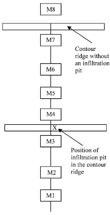 | |
| Fig. 1: | Positions of access tubes from the infiltration pit |
An IH neutron probe was used to measure soil water content at weekly intervals. Readings were taken at 0.1, 0.2, 0.3 m and then at 0.2 m intervals for the remaining depth of the tube using a counting rate of 16 sec.
RESULTS AND DISCUSSION
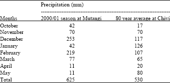
The rainfall commenced on the 27th of October when 40 mm of rainfall was received. There were 7 occasions when daily rainfall amounts exceeding 40 mm were received. The total rainfall in the 2000/01 season was above the long term average (Table 1). January of 2000/01 was below the long term average. It was characterised by a mid season drought when only 42 mm of rainfall was received. Both December and February received about double the long-term average rainfall.
Soil moisture storage responded to rainfall, when total soil moisture increased after rainfall events and decreased during dry periods. There were four occasions when soil moisture increased in response to rainfall (Fig. 2).
Apart from M1, all the other access tubes had similar amounts of soil moisture at the beginning of the measurement period on the 20th of October 2000. Figure 2 shows that M3 and M7 had the highest and least soil moisture storage, respectively. The ranking in total soil moisture were not consistent over the measurement periods. On average the ranking was M3>M4>M2>M5>M6>M7.
The access tubes that were close to the infiltration pits (M3 and M4) had more soil moisture storage with M3 that is down the slope and adjacent to the infiltration pit, having more soil moisture than M4 that is located up slope. In general the access tubes that are located down slope had more moisture storage compared to those that are up slope. Water moves downwards through gravity hence it is the areas that are down slope that benefit more from the water that is harvested and stored in infiltration pits. However, those areas (M4) close and above the infiltration pits have more moisture than those far away because of upward capillary movement of water.
M1, though it is 16 m away from the infiltration pits, had consistently similar levels of soil moisture with M3 that is close to the infiltration pit. This can be explained by the closeness of M1 to a trench that is dead level and stored water for days after rainfall events.
The difference between soil moisture storage in the access tubes narrowed during wet periods like 28th December and 28th February because all the access tubes benefit from rainfall. The difference in soil moisture storage increases during dry periods because the moisture that is lost as evapotranspiration is not replenished at all in the access tubes that are far away from the infiltration pits. The water from the infiltration pits that moves laterally downwards replenishes those tubes that are closer to the infiltration pits. Access tubes that are far away from the infiltration pit are notreplenished hence the difference in soil water between these access tubes increases during the dry periods.
| Table 1: | Long term average and growing season rainfall in the 2000/01 season at the study site and Chivi (that is 12 km from the study site) |
 | |
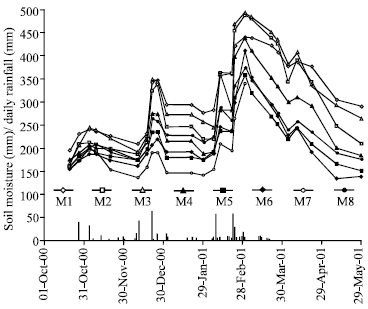 | |
| Fig. 2: | Seasonal fluctuations in soil moisture content (mm) for the eight access tubes |
It is during the dry spells like January and early February (Fig. 2) when the benefits of infiltration pits are appreciated. Infiltration pits store direct rainfall and runoff water from the fields and this water slowly seeps down slope benefiting the crops during these mid season droughts. However, infiltration pits might be a problem when there is too much rainfall because areas downslope can be water logged.
Though this study has demonstrated the advantages of infiltration pits on soil moisture, there are further areas of research that need attention. These relate to the spacing of infiltration pits in the contour ridge for different soil types and slope and their optimum depth for different soil types. There is also need to quantify the effect of infiltration pits on crop yields both above and below infiltration pits. The standard contour ridge is meant to drain water and conserve soil between contour ridges. The engineering design was such that the spacing depends on soil type and slope[9]. Such spacings might not be appropriate for the infiltration pits. There is need to establish how far the benefits of infiltration pits extend down slope for different soil types and this could be incorporated in the designing of the contour ridges where infiltration pits are dug in.
REFERENCES
- Twomlow, S.T. and P.M.C. Bruneau, 2000. The influence of tillage on semi-arid and soil water regimes in Zimbabwe. Geoderma, 95: 33-51.
Direct Link - Nyakatawa, E.Z., 1996. Rain water and soil fertility management for sustainable cropping on sandy soils in semi-arid South East Zimbabwe. J. Sustainable Agric., 7: 19-34.
Direct Link - Nyakatawa, E.Z., M. Brown and D. Maringa, 1996. Maize and sorghum yields under tied ridges and fertilised sandy soils in semi-arid South-East Zimbabwe. Afr. Crop Sci. J., 4: 197-206.
Direct Link - Vogel, H., 1993. Tillage effects on maize yields, rooting depth and soil water content on sandy soils in Zimbabwe. Field Crops Res., 33: 367-384.
CrossRef