

Yan Jiao
College of Highway Engineering, Chang’an University, Xi’an China 710064, China
Zhou Bowen
College of Highway Engineering, Chang’an University, Xi’an China 710064, China
Hu Siranc
School of Automobile, Chang’an University, Xian China 710064, China
Information Technology Journal
Year: 2012 | Volume: 11 | Issue: 4 | Page No.: 520-523





ABSTRACT
With the rapid development in the construction of highway recently, the traffic volume is increasing rapidly which cause the critical problem of the pavement maintenance and management. Current systems couldn’t meet the need of it and also have an impact on the development and operation of our highway. In this study, a management and service platform for pavement, based on an iPad terminal with GIS, is designed. On the basis of the existing pavement and lots of researches and experiments, it also relies on the GIS technology which is powerful in spatial orientation, graphics processing and displays, iPad terminal with strong processing and remote infinite transmission. Then it will solve some problems in our maintenance of pavement to some extent.
PDF Abstract XML References Citation
Article History
Received: October 28, 2011;
Accepted: November 19, 2011;
Published: January 20, 2012
How to cite this article
Yan Jiao, Zhou Bowen and Hu Siranc, 2012. Study on the Application of a Management System for Pavement Based on iPad Terminal with GIS. Information Technology Journal, 11: 520-523.
DOI: 10.3923/itj.2012.520.523
URL: https://scialert.net/abstract/?doi=itj.2012.520.523
DOI: 10.3923/itj.2012.520.523
URL: https://scialert.net/abstract/?doi=itj.2012.520.523
INTRODUCTION
Along with the development of our country’s economic construction, highway construction business in China is developing rapidly, especially the highway construction (Yuli, 1998). Especially the eastern coastal economic developed area in the construction of highway network has been basically completed (Wei, 2006) but the pavement maintenance management problem is growing outstanding (Wei et al., 2006). Data update lag exists mostly. Decision-making ability is weak. And it is difficult to use. All these cause high traffic accident rate (Jing and Lianyu, 2004), unreasonable pavement maintenance plan, and road reconstruction problems. Therefore, a new generation of highway pavement maintenance management platform is in urgent need. This study, based on the literature collection and analysis, did applied research on a management and service platform for pavement (Fig. 1), based on an iPad terminal with GIS. (Shufang, et al., 2005) which can work out with real-time, accurate and efficient information support system in satellite navigation system, enhance the function of PMS and make up the shortcomings of the present stage of data management in the application of PMS, achieve the docking of data and function between iPad terminal and the PMS which works for supplying the maintenance management institutions for accurate and convenient information service and decision support (Huoming et al., 2007). Thus reasonable, timely and efficient decisions can be made with high economic and applicable value.
This article is mainly divided in to the following five steps:
| • | Through consulting a number of literature, understand the research trends at home and abroad, analyze the problems, propose corresponding countermeasures and establish the researching direction |
| • | The research work was started from three aspects: the pavement maintenance management work, road maintenance management system and iPad terminal, and analysis was made from the integration of the three |
| • | The system function module development was based on the advantage of iPad terminal, GIS, mathematical model. Main functions are as follows: road foundation information query, pavement performance development trend analysis, pavement condition testing and evaluation results, pavement condition and disease statistics and information, etc |
| • | Research on the power-off protection and encrypting transmission of data system |
| • | The latest Microsoft C language development and SQL Server 2008 used in the backend database, important elements in developing iPad terminal pavement maintenance management Service platform based on GIS, by using the latest. net Framework, Microsoft and the Web Service in the distributed system |
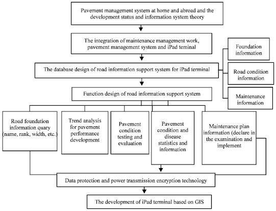 | |
| Fig. 1: | Flow chart of management and service platform for pavement |
SYSTEM DESIGN
Software structure: Compared with the traditional pavement management system, this system is based on geographic information system and iPad terminal. Its software structures are graphics management and object-oriented function modular design development. The former mainly operates on special and attribute data. This is more complicated than the traditional way of dealing with attribute data. As for the users, it is convenient for them to realize human-machine interaction and reduce the technical requirements and working intensity. The latter can achieve the relative independence between the different function modules. The data exchange between the different function modules is two-way convection, so the different function modules are both opposite and unitary. The modular design of the object oriented can achieve good human-machine interaction and system scalability and compatibility.
Platform advantage: The system consists of 2 bulks, ipad terminal platform in hardware and highway pavement management system in software. The iIPad terminal is famous for its first-class properties which is lighter than 1 kg and has just four buttons as a tablet computer. Equipped with so many complex functions, it can surf the Internet, email watch the ebook, play audio or video and so on at the base of touch. It’s an integration of powerful hardware and software systems which is only 13.4 mm thin, bearing excellent touch screen with 1024x768 pixel. Therefore, ever such advantages of ipad terminal are as follows:
| Step 1: | Big visible angle of IPS screen and exquisite color. It’s easy to control and use |
| Step 2: | Not only can the IPS screen not leave any ter wave after touching, but the response speed is also pretty fast, which makes the images movement locus clear It’s convenient to know about pavement information |
| Step 3: | 1 GHz apple A4 processor has a strong processing power. It can analyse and arrange the upload data swiftly with its predicative function |
| Step 4: | This terminal has super flying power. Managers are able to learn about all the pavement conditions flexibly and conveniently in time when on a business trip |
| Step 5: | The long distance transmission function, including remote infinite transmission like Wi-Fi and 3G function which lets the system receive the latest data at any time so that perfect pavement maintenance plans can be made |
System function module: The system consists of 3 functions. That is user experience function, basic data function and evaluation and decision-making function.
User experience function: User’s experience function is to advocate people-oriented design idea. Through the effective combination with iPad terminal and the powerful graphics processing of GIS and expression, space simulation and spatial decision support, the drab data can be performed by a more intuitive way. Meanwhile, humanized operation makes the efficiency be greatly increased.
GIS dynamic schemes: GIS dynamic schemes intuitive express all kinds of information in the electronic road map in the environment of Arc GIS. Through the real-time data of extraction from dynamic database and GIS deduce, it eventually forms dynamic simulation electronic chart reflected the present situation. Combined with the iPad touch screen, it is clear and convenient for the users to understand the information of road and bridge’s maintenance departments, maintenance history, present situation within the jurisdiction. And it can also use the GPS receiver function of iPad terminal and 3G mobile phone with unlimited transmission function to show existing roads real-time information, summarize and remind users of road congestion, construction, maintained and completion time, etc.
Picture play: Picture play function works as playing the whole road tests situations in the form of dynamic image, showing pictures of the areas having problems and combining charts to reflect the road health conditions, which is convenient for managers to know about roads conditions immediately. Users can also well experience the actual situations of pavement through video.
DEM road digital elevation model: Digital elevation model is the digital expression of attribute information of ground form, with the digital description of space position characteristics and terrain attribute. Elevation is the third coordinate in geographical space. Compared with traditional GIS system, the establishment of DEM is necessary supplement.
Based data function: The basic functions of iPad terminal service platform are about how to manage, search and import data. And these kind of function is the base of all the rest of the system function. Based on the technology of GIS, using the unique geographical spatial analysis ability, fast space location search and complex injures function, it can manage the data in time. At the same time, the function of the implementation of the iPad is inseparable from the strong ability to deal with the terminal CPU.
Evaluation decision function:
| • | Evaluation of the pavement technical condition. Mainly used in evaluation and tabulate statistics of the current pavement. According to the latest standard of evaluation of highway technical condition, the road grade and the kinds of pavement, the evaluation includes 6 index, namely damage, evenness, anti-slip performance, rutting depth, structural strength and comprehensive index |
| • | Demand analysis of pavement maintenance. In the decision, the managers should know the maintenance segments in the planning years and the mode of maintenance. In addition, in this system some parameters of the model can be set by users, such as the standard, decision tree and decision model. Afterwards, it will analyze the maintenance requirement in the planning year |
| • | Predictive analysis of road condition. The road performance prediction model is the basis of analysis and planning of the maintenance. And in this system, it will predict the following 2 years based on two-parameter tracking correction model. So the parameters in this model are updating over time, in this way the result is more accurate |
| • | Management of parameters in highway model. The main function is to set the parameters and standards in analysis and decisions. It is the basis of evaluation and decision. In addition, the parameters can be adjusted according to requirements |
| • | Analysis of building or rebuilding. Based on decision mode, traffic volume and road condition in recent years, it will offer the solutions in GIS figure |
| • | Analysis of sensibility and risk. In the process, it shows the feasibility of each solution and the potential risk in the chosen solution by coefficient. Afterwards, compared the output coefficients and finally chose the best solution |
Maintenance reports: In this system, the maintenance report can be finished automatically, according to the highway data base, pavement management system and the analysis of other functional module. The report mainly includes: the basic condition of road network, evaluation of road technical condition, maintenance requirement analysis, planning of maintenance, investment benefit of maintenance, economic evaluation of maintenance. That is the basis of the final solution.
Experts forum: It is the additional function of this system. In the forum, the users could communicate with certain experts by encryption chatting, video or leaving message. Or they could put a question at the public page waiting for answers.
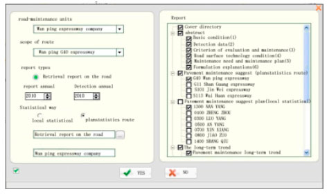 | |
| Fig. 2: | Conservation report |
At the same time, the experts could enter the data base of the user to find useful data for the solutions. For the difficult problems, they could discuss in public. In conclusion, the system will help the places, where the maintenance is not appropriate, save resources and improve safety.
APPLICATION EXAMPLES
The following is the brief description of the report generation function of the iPad proposed in this paper, with the example of a certain road segment. Choose the report generation option and then the result will be summarized in word, according to evaluation model, prediction model and decision model, shown in Fig. 2.
CONCLUSIONS
In conclusion, with the popularization of iPad and especially the appearance of new generation of iPad, the combination of pavement maintenance management system and iPad will have more functions then before, such as infinite transition, long stand by time and intelligent decision. Furthermore, to achieve the target of information visualization and scientific decision, it is the trend of pavement maintenance management system with GIS, which will improve the system. With SQL language, it is easy to inquire between spatial information and attribute information. As a result, the iPad proposed in this paper will obviously improve the pavement maintenance management system in our country and it has great influence on highway managers and technic standardization.
REFERENCES
- Wei, L., C. Peifeng and H. Dongpo, 2006. Pavement management system based on GIS. Forest Eng., Vol. 22.
Direct Link - Jing, H. and W. Lianyu, 2004. Application of web GIS in road management system: Computer and communications. Comput. Commun.
Direct Link