
S. Dinesh
Science and Technology Research Institute for Defense, Ministry of Defense, Malaysia
Journal of Applied Sciences
Year: 2007 | Volume: 7 | Issue: 18 | Page No.: 2610-2616


ABSTRACT
In general, geomorphological landforms are viewed as Boolean objects. However, recent studies have shown that landforms are more suitable to be viewed as fuzzy objects, whereby a landform is defined as a region in the continuum of variation of the surface of the earth. In this study, the fuzzy classification of simulated droughts and floods of water bodies is performed. First, concepts of mathematical morphology are employed to generate simulated droughts and floods of water bodies. Fuzzy classification is then performed based on by the average of Boolean memberships of the water bodies over the levels of droughting and flooding. The proposed fuzzy classification method is useful for statistical analyses and determination of sample schemes.
PDF Abstract XML References Citation
How to cite this article
S. Dinesh, 2007. Fuzzy Classification of Simulated Droughts and Floods of Water Bodies. Journal of Applied Sciences, 7: 2610-2616.
DOI: 10.3923/jas.2007.2610.2616
URL: https://scialert.net/abstract/?doi=jas.2007.2610.2616
DOI: 10.3923/jas.2007.2610.2616
URL: https://scialert.net/abstract/?doi=jas.2007.2610.2616
INTRODUCTION
In Boolean set theory, if an object belongs to a set, it is assigned an integer value of 1 as membership for that set. If the object does not belong to that set, it is assigned with a membership of 0. In fuzzy set theory, a core concept is defined and objects which exactly match that core concept are assigned with a class membership of 1. The membership is assigned a reducing real number for objects as they are increasingly dissimilar from that core concept, when the membership is assigned a value of 0 (Zadeh, 1965, 1975, 1978; Novak, 1989; Zimmermann, 1991; Klir and Yuan, 1995, 1996; Novak et al., 2000; Gottwald, 2001; Ross, 2004).
In general, geomorphological landforms are viewed as Boolean objects. However, recent studies have shown that landforms are more suitable to be viewed as fuzzy objects, whereby a landform is defined as a region in the continuum of variation of the surface of the earth (Gale, 1972; Robinson, 1988, 2003; Burrough and Heuvelink, 1992; Irvin et al., 1997; Fisher and Wood, 1998; Burrough et al., 2000, 2001; Cheng and Molenaar, 1999a,b; Fisher, 2000a,b; MacMillan et al., 2000, 2007; Dehn et al., 2001; Varzi, 2001; Mackay et al., 2003; Fisher et al., 2004; Schmidt and Hewitt, 2004; Carré and McBratney, 2005; Drãgut and Blaschke, 2006; Dinesh, 2007a,b). In general, three approaches have been employed to perform the fuzzy classification of various landforms. The first approach, known as the semantic import model, uses a priori knowledge, such as height, to assign a value of fuzzy membership to a landscape feature with a particular metric property (Dehn et al., 2001). Usery (1996) determined the fuzziness of Stone Mountain, Georgia, using the height above elevation as a membership function, with membership increasing with height. Cheng and Molenaar (1999a and b) used height to determine membership functions of separate elements of dynamic beach landforms. The second approach, known as the similarity relation model, uses surface derivatives, such as slope and curvature, as input to a multivariate fuzzy classification which yields the membership values (Irvin et al., 1997; Burrough et al., 2000, 2001; MacMillan et al., 2000, 2007; Schmidt and Hewitt, 2004; Carré and McBratney, 2005; Drãgut and Blaschke, 2006). In the third approach, fuzzy classification of landforms is performed based on landforms extracted over multiple scales of measurement. In Fisher et al. (2004) and Dinesh (2007a and b), the fuzzy classification of geomorphometric and physiographic features extracted from multiscale digital elevation models was performed based on by the average of Boolean memberships of the extracted features over the scales of measurement.
In this study, the fuzzy classification of simulated droughts and floods of water bodies is performed. First, concepts of mathematical morphology are employed to generate simulated droughts and floods of water bodies. Fuzzy classification is then performed based on by the average of Boolean memberships of the water bodies over the levels of droughting and flooding.
GENERATION OF SIMULATED DROUGHTS AND FLOODS OF WATER BODIES USING MATHEMATICAL MORPHOLOGY
Mathematical morphology is a branch of image processing that deals with the extraction of image components that are useful for representational and descriptional purposes. Mathematical morphology has a well developed mathematical structure that is based on set theoretic concepts. The effects of the basic morphological operations can be given simple and intuitive interpretations using geometric terms of shape, size and location. The fundamental morphological operators are discussed by Matheron (1975), Serra (1982) and Soille (2003). Morphological operators generally require two inputs; the input image A, which can be in binary or grayscale form and the kernel B, which is used to determine the precise effect of the operator.
Dilation sets the pixel values within the kernel to the maximum value of the pixel neighbourhood. Binary dilation fills the small holes inside particles and gulfs on the boundary of objects, enlarges the size of the particles and may connect neighbouring particles (Duchane and Lewis, 1996). The dilation operation is expressed as:
| (1) |
Erosion sets the pixels values within the kernel to the minimum value of the kernel. Binary erosion removes isolated points and small particles, shrinks other particles, discards peaks on the boundaries of objects and disconnects some particles (Duchane and Lewis, 1996). Erosion is the dual operator of dilation:
| (2) |
where, Ac denotes the complement of A and B is symmetric with respect to reflection about the origin.
Droughting and flooding simulation was implemented by performing erosion and dilation, respectively, on the water bodies using square kernels (Dinesh, 2007c, d). However, the disadvantage of this approach is that the rate of change across the levels of drougthing and flooding is too larger for the purposes of fuzzy classification. An alternative approach is to perform droughting and flooding simulation using morphological opening and closing.
An opening is defined as erosion followed by a dilation using the same kernel for both operations. Opening tends to remove some of the foreground pixels from the edges of regions of foreground pixels. It preserves the foreground regions that have a similar shape to kernel, or that can completely contain the kernel, while discarding all other regions of foreground pixels (Fisher et al., 1994). The opening operation is expressed as:
| (3) |
A closing is defined a dilation followed by an erosion using the same kernel for both operations. Closing tends to enlarge the boundaries of foreground regions in an image and shrink background holes in such regions. It preserves the background regions that have a similar shape to the kernel, or that can completely contain the kernel, while eliminating all other regions of background pixels (Fisher et al., 1994). The closing operation is expressed as:
| (4) |
Droughting and flooding simulation is implemented by performing opening and closing, respectively, on water bodies using square kernels. Opening reduces the area of water bodies, mimicking droughting, while closing increases the area of water bodies, mimicking flooding. The level of droughting/flooding is indicated by the kernel size.
Gothavary River, which lies in central India, originates near Triambak in the Nasik district of Maharashtra and flows through the states of Madhya Pradesh, Karnataka, Orissa and Andhra Pradesh. Although its point of origin is just 80 km away from the Arabian Sea, it journeys 1,465 km to empty into the Bay of Bengal. Some of its tributaries include Indravati, Manjira, Bindusara and Sarbari. Some important urban centers on its banks include Nasik, Aurangabad, Nagpur, Nizamabad, Rajahmundry and Balaghat. The Gothavary River is often referred to as the Vriddh (Old) Ganga or the Dakshin (South) Ganga. The Gothavary River catchment has an area of 312, 870 km2 and receives more than 85% of its annual rainfall during the monsoon season (June-September). Hence, the water resource in this river is largely due to monsoon rainfall and largely affected by monsoon extremities, resulting in floods during some years and droughts during others.
Figure 1 shows a number of water bodies of varying shape and sizes situated in a portion of the flood plain region of Gothavary River.
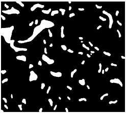 | |
| Fig. 1: | Water bodies of varying shapes and sizes traced from IRS 1D remotely sensed data |
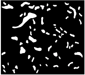 | |
| Fig. 2: | The water bodies after the removal of incomplete water bodies |
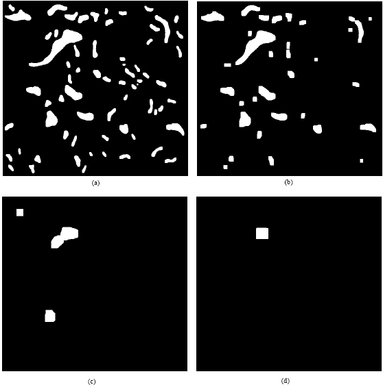 | |
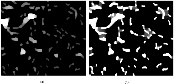
| Fig. 3: | The generated simulated droughts of the water bodies at droughting levels of: (a) 5 (b) 10 (c) 20 and (d) 30 |
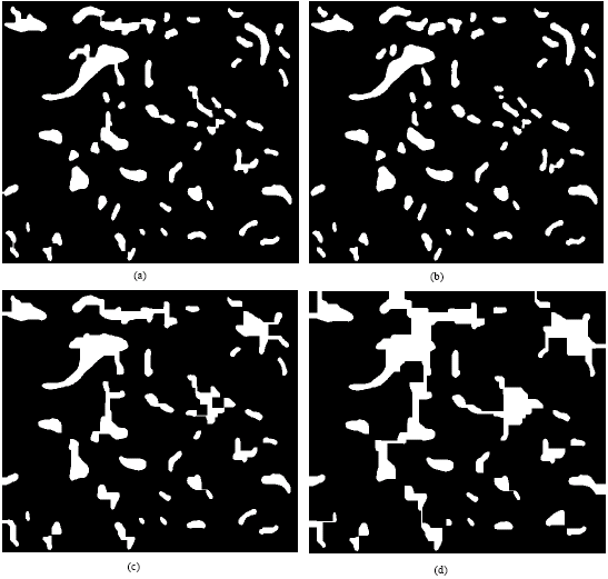 | |
| Fig. 4: | The generated simulated floods of the water bodies at flooding levels of: (a) 5 (b) 10 (c) 20 and (d) 30 |
 | |
| Fig. 5: | Fuzzy memberships of the (a) simulated droughts (b) simulated floods. The membership values ranging from 0 to 1 are rescaled to the interval of 0 to 255 (the brightest pixel has the highest membership value) |
| Table 1: | Areas of the generated simulated droughts and floods of the water bodies |
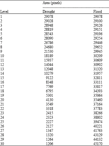 | |
The water bodies were traced from IRS 1D remotely sensed data. Due to the impracticalities of dealing with incomplete water bodies, these incomplete water bodies are removed and only the complete water bodies are considered (Fig. 2). Simulated droughts (Fig. 3) and floods (Fig. 4) of the water bodies for levels of 1-30 are computed. The areas of the generated simulated droughts and floods are shown in Table 1.
FUZZY CLASSIFICATION OF SIMULATED DROUGHTS AND FLOODS OF WATER BODIES
In order to perform the fuzzy classification of the generated simulated droughts and floods, it is first assumed that at any droughting/flooding level, the water bodies are Boolean objects. Hence, whereby a terrain can be divided into two classes: mountain (mx= 1) and non-water bodies at location x. The main reason why simulated droughts and floods are more suitable to be considered as fuzzy objects is that the Boolean assignment of water bodies is not necessary stable under repeated observation at different levels of droughting/flooding.
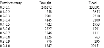
| Table 2: | Distribution of the pixels based on their fuzzy memberships |
 | |
Thus, if mx|l1 = 1 for a particular landscape, it does not mountain (mx= 0), where mx is the Boolean membership of follow that either mx|l2 = 1, or mx|l3 = 1, where l1, l2 and l3 indicate different levels of droughting/flooding.
The fuzzy membership of water bodies μ at location x can be given by the average of Boolean memberships of that feature over the levels of droughting/flooding:
| (5) |
Figure 5 shows the fuzzy memberships of the generated simulated droughts and floods. The distribution of the pixels based on their fuzzy memberships is shown in Table 2.
CONCLUSION
In this study, the fuzzy classification of simulated droughts and floods of water bodies is performed. First, concepts of mathematical morphology were employed to generate simulated droughts and floods of water bodies. Fuzzy classification was then performed based on by the average of Boolean memberships of the water bodies over the levels of droughting and flooding. The proposed fuzzy classification method is useful for statistical analyses and determination of sample schemes.
ACKNOWLEDGMENTS
The author is grateful two anonymous reviewers for their valuable comments which helped strengthen this manuscript.
REFERENCES
- Burrough, P.A., P.F.M. Van Gaans and R.A. MacMillan, 2000. High-resolution landform classification using fuzzy k-means. Fuzzy Sets Syst., 113: 37-52.
Direct Link - Burrough, P.A., J.P. Wilson, P.F.M. Van Gaas and A.J. Hansen, 2001. Fuzzy k-means classification of topo-climatic data as an aid to forest mapping in the Greater Yellowstone Area, USA. Landscape Ecol., 16: 523-546.
Direct Link - Dehn, M., H. Gartner and R. Dikau, 2001. Principles of semantic modeling of landform structures. Comp. Geosci., 27: 1005-1010.
Direct Link - Dinesh, S., 2007. Fuzzy classification of physiographic features extracted from multiscale digital elevation models. Applied Math. Sci., 1: 939-961.
Direct Link - Dragut, L. and T. Blaschke, 2006. Automated classification of landform elements using object-based image analysis. Geomorphology, 81: 330-344.
Direct Link - Fisher, P., J. Wood and T. Cheng, 2004. Where is Helvellyn? Fuzziness of multiscale landscape morphometry. Trans. Inst. Br. Geographers, 29: 106-128.
Direct Link - Klir, G.J. and B. Yuan, 1995. Fuzzy Sets and Fuzzy Logic: Theory and Applications. 1st Edn., Prentice Hall Inc., New Jersey, USA., ISBN-13: 9780131011717, Pages: 574.
Direct Link - Mackay, D.S., E.A. Douglas, T.G. Stith, S. Sudeep, B.E. Evers and S.N. Burrows, 2003. Automated parameterization of land surface process models using fuzzy logic. Trans. GIS., 7: 139-153.
Direct Link - MacMillan, R.A., W.W. Pettapiece, S.C. Nolan and T.W. Goddard, 2000. A generic procedure for automatically segmenting landforms into landform elements using DEMs, heuristic rules and fuzzy logics. Fuzzy Sets Syst., 113: 81-109.
CrossRef - Schmidt, J. and A. Hewitt, 2004. Fuzzy land element classification from DTMs based on geometry and terrain position. Geoderma, 121: 243-256.
CrossRef - Zadeh, L.A., 1975. The concept of a linguistic variable and its application to approximate reasoning-I. Inform. Sci., 8: 199-249.
CrossRefDirect Link - Zadeh, L.A., 1978. Fuzzy sets as a basis for a theory of possibility. Fuzzy Sets Syst., 1: 3-28.
CrossRefDirect Link