
Nidal A. Hadadin
Department of Civil Engineering, The Hashemite University, P.O.Box, 150459, Zarqa 13 1 1 5, Jordan
Journal of Applied Sciences
Year: 2005 | Volume: 5 | Issue: 10 | Page No.: 1777-1784


ABSTRACT
Variables needed for hydrologic design of hydraulic structures include the rainfall intensities, critical storm duration (concentration times for determination of peak discharges) for the catchments area, and the selected frequencies (return period). These variables together constitute the design storm. In this study, the relationship between the rainfall amount, duration and frequency are studied for Mujib basin in Jordan. Intensities-Duration-Frequency (IDF) equations were developed for each of the 8 rainfall recording station in the basin. The 8 IDF equations obtained were compared with the curves obtained by Gumbel method and Water Authority of Jordan (WAJ); the results predicted by the writer are closer to the measured values. There are some differences in the results between this study and the studies of other investigators; these differences are due to: differences in the record length used by this study and WAJ study; extrapolation of WAJ curves to include the 5 min duration and some of the relative error was due to small values of reading. Peak discharges were calculating for different location in the basin; it was found that the peak discharge which gotten from Manning`s equation is closed to the peak discharge that gotten from rational method at recurrence interval equal to 25 years.
PDF Abstract XML References Citation
How to cite this article
Nidal A. Hadadin, 2005. Rainfall Intensity-Duration-Frequency Relationship in the Mujib Basin in Jordan. Journal of Applied Sciences, 5: 1777-1784.
DOI: 10.3923/jas.2005.1777.1784
URL: https://scialert.net/abstract/?doi=jas.2005.1777.1784
DOI: 10.3923/jas.2005.1777.1784
URL: https://scialert.net/abstract/?doi=jas.2005.1777.1784
INTRODUCTION
Hydrologic synthesis technique is a powerful tool for aiding engineers and hydrologists in evaluating surface water resources. Since rainfall data is generally in abundance in comparison to runoff data, the attempt has been to convert rainfall to runoff. Jordan is a country located in a semi-arid region; therefore, water is a valuable resource for this country. Rainfall is one of the most important sources of water. However, its random occurrence sometimes creates a lot of problems. Furthermore, many regions throughout Jordan lack the hydrologic data that required for detailed analysis of basin responses[1]. These basins responses to the rainfall events may cause considerable damage to developments in their surroundings. Planning and protection of these basins, requires estimates of expected discharge from rainfall events of different magnitudes. Traditional estimation techniques are not feasible due to the lack of available runoff data.
The practice regarding the hydrologic design in Jordan has been using the IDF curves developed by Ibbitt[2]. Ibbitt’s curves were developed from the correlation of the annual average precipitation in Jordan with stations in California, USA. An independent study analyzing the rainfall data for 40 major stations in the Kingdom was published by the WAJ[3]. The accuracy of the recording rainfall charts (mass curves) was limited to 20 min the results for shorter duration were estimated by extrapolation. The curves corresponding to 2 and 5 years return period were extended visually, which can be considered as an insubstantial point in this technique. Then the intensities for 10, 25, 50, and 100-year return periods were calculated in term of the 2 and 5 years intensities for the same duration using equations derived from the Gumbel’s distribution method[4]. Hydrologic phenomena are characterized by great variability, randomness, and uncertainty[5]. Precipitation and streamflow must be treated as random variables, with associated measures of frequency that represent percentage of time, or probability[6,7].
Rainfall IDF relationships can be expressed in various formats. An isohytal map prepared by the U.S. Geological Survey for Illinois[8], NWS atlases consist of sets of maps covering particular regions, with a map for each combination of recurrence interval and duration. The Texas Department of Transportation[9] hydraulic design Manual, related rainfall intensity in inch per hour to rainfall duration in minutes as a function of recurrence interval for each of the 254 countries of the state.
In evaluation the frequency of intense rainfall, mention must be made of some classic studies. The later one of these is by Dillon[10] there are deferent methods such as: Bilham[11] method, Federick Charles Bell[12], and NERC[13] (Natural Environment Research Council. Chen[14] utilized a method similar to Bell method[12].
The previously developed formula was based on the average depth-duration ratio and the mean depth-frequency ratio. The Chen’s formula requires three-rainfall depth (i.e., 10 year-1 h, 10 year-24 h and 100 year-1 h). The ratio of 1 h to corresponding 24 h depth and 100 year to corresponding 10 year depth can be computed from the requires three rainfall depths, so that geographical variation of rainfall can be evaluated in terms of both ratios. This method was adopted in this research to develop the IDF relationship for the Mujib basin in Jordan.
Available data: In order to determine the anticipated peak discharges for each selected catchments area; it was necessary to analyze the following:
| • | Topographic maps |
| • | Watersheds characteristics |
The following are the most important watershed parameters considered in this study for the purposes of determining the surface runoff coefficients:
| • | Infiltration potential |
| • | Vegetation cover |
| • | Depression storage potential |
| • | Rainfall records |
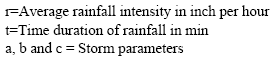
Frequency, duration and depth: Rainfall data is specified by three variables: Frequency, duration and either depth or mean intensity. The frequency of a rainfall event is usually expressed by its return period or recurrence interval, which may be defined as the average interval of time within which the magnitude of the event will be equaled or exceeded once.
Frequency analysis may be carried out with either an annual series or partial series; annual series is an array of values consisting of the largest event in each year, while a partial (or exceedence) series is an array of all value exceeding some arbitrary base level, regardless of the year in which they occur. In a partial series there may be a number of values from the same year, if they are all above the selected base level, and there may be no values at all from other years when the base level is not reach.
The magnitudes of rainfall events are given by total depth occurring in a particular duration. In some past analysis the mean intensity (depth divided by duration) has been used instead of total depth but this has sometimes given the misleading impression that rainfall intensities are approximately constant throughout the specified duration. In reality the intensity is highly variable and rarely remains constant for more than a few minutes.
Duration: The duration of a design storm must be at least equal to the time of concentration that is defined as the time for a water particle to travel from the most remote position of the watercourse in the catchment area to the control section under investigation.
For small plots having no defined flow channels from which runoff occurs as laminar over land flow, Chow[15] suggested the following formula for evaluation the time of concentration in hours:
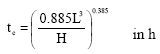 | (1) |
| L | = | The distance from the far most point to the outlet at hydraulic structure in km |
| H | = | Total fall in level from the far most point to the outlet in meter |
Typically, the concentration times required may vary from a minute to 5 min in urban areas, and to 24 h or more for larger catchments.
Frequency: Establishment of the appropriate frequency for a particular project is a policy decision, reflecting such factor as the risks involved and the project economics, for urban drainage works, the recurrence intervals usually vary from 2 to 20 years, with the higher values corresponding to higher value districts, for highway drainage works the typical return period range from 10 to 50 year.
Detention reservoir and dams are usually designed for 100 year period. Thus the rainfall intensities for duration from 5 min to 24 h and return period of 2 to 100 years are usually needed for the design of various hydraulic structures.
Present approach: Chen[14] used the following empirical rainfall intensity duration formula in the analysis
| (2) |
 |
The value of a, b and c may vary with meteorological localities, the intensity can be alternatively expressed in terms of the depth by multiplying the right hand side by t/60 The corresponding rainfall depth duration formula thus becomes,
 | (3) |
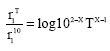
The standard intensity-duration relationship that seems independent of frequency may be written as:
| (4) |
| = | T-year, t - h (or min), average rainfall intensity inch per hour | |
| = | T-year, 1h, average rainfall intensity inch per hour |
a1, b1 and c1 = standard storm parameters can be rearrange in the form
 | (5) |
Because the above Eq. 2 and 5 are identical, comparing the parameters of both equations yields:
Bell[12] proposed the following empirical formula for depth frequency ratio of any return period between 2 and 100 year,
| (6) |
The above empirical formula can be written as:
| (7) |
| α, γ | = | Unknown parameter yet to be determined from rainfall data. |
| T | = | Return period in year |
The rainfall depths for two return periods can be arbitrarily selected for this purpose. The choice of 10 year and 100 year storms for the same duration and substitution of the corresponding values of ![]() and T yields,
and T yields,
| (8) |
| (9) |
From which one readily finds that
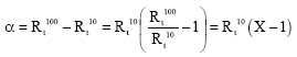 | (10) |
in which,
| (11) |
| (12) |
Therefore,
| (13) |
After some mathematical manipulation one can get:
| (14) |
In order to incorporate the above equations; the intensity frequency formula for 1 h duration needs to be specified and for t = 1 h is:
 | (15) |
In which X is now defined as:![]()
Combining Eq. 4 and 15,
 | (16) |
This is the general expression of the rainfall Intensity-Duration-Frequency (IDF) relation.
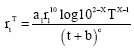
Analysis procedures: For location with complete rainfall records, the traditional analysis consisted of abstracting the maximum intensities of specified duration from storm mass curve. Table 1 is an example for maximum rainfall depth for Dhiban rainfall station in the Mujib Basin. Annual maximum series is formed for two durations i.e., 1 and 24 h.
Major disadvantages of this procedure are:Dealing with a large number of autographic charts for each rainfall station in the basin, which is a tedious work, and rainfall data for each year of record must be completed.
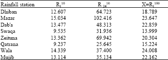
The 10 year/1 h, 10 year/24 h and 100 year/1 h rainfall depths are required to apply Chen’s formula. These depths can be obtained directly from frequency analysis by applying Gumbel’s distribution method.
| Table 1: | Annual maximum rainfall depths (mm) for specified duration for Dhiban station |
 | |
The stepwise procedure to determine the rainfall depth magnitude of the desired return period by applying Gumbel’s method is given below:
| • | List the annual maximum intensities for the required duration of 1 h and 24 h |
| • | Compute |
| (17) |
 | (18) |
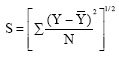
| • | The maximum rainfall amounts for duration and frequency were obtained by applying the following equation: |
 | (19) |
| Y | = | maximum rainfall amounts. |
| = | Arithmetic means for maximum rainfall | |
| Sn-1 (Y) | = | Standard deviation |
| SN | = | Reduced standard deviation (Table 2) |
| YN | = | Reduced mean (Table 3) |
| YT | = | Logarithmic constant (Table 4) |
| • | Compute the desired rainfall depths R110, R 2410 and R 1100 for each rainfall station by equation: |
| (20) |
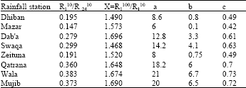
After the 10-year 1-h (R110), 10 year 24 h (R2410) and 100 year 1 h (R1100) rainfall values are gotten, then Chen’s formula is applied, in which R is the Y value obtained from Eq. 20.
One can find standard storm parameter (a1, b (=b1) and c (=c1) from Chen[14].
Then substituting the values of a1 R110 and X in the equation:
| (21) |
Consequently from Eq. 16 we get:
| (22) |
This is the general rainfall Intensity-Duration-Frequency (IDF) formula.
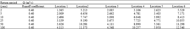
Peak discharge analysis: The rational method is well suited for small homogenous catchments area and therefore is used in this study for the purpose of calculating the peak discharges contributing to the various location in the basin; these results were compared with the peak discharges that gotten by using Manning equation.
The peak discharges were estimated from the analysis the following parameters:
Catchment areas: The catchment areas boundaries were defined on the 1:25000 topographic maps. The actual areas were determined by planimeter reading.
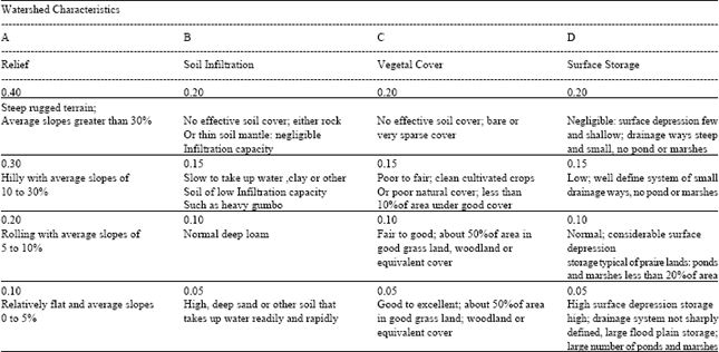
Runoff coefficients: The runoff coefficient (C) required for the rational method was determined by the catchments characteristics. From observation during many site visits the following individual runoff coefficient were selected from Table 5.
Soil infiltration = 0.050, Vegetal cover = 0.20
| Table 2: | Reduced standard deviation SN (y)[3] |
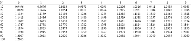 | |
| Table 3: | Reduced mean YN[3] |
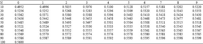 | |
| Table 4: | Probability P and Logarithmic constant for standard return period T[3] |
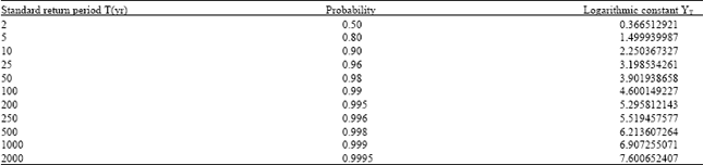 | |
| Table 5: | Typical runoff coefficient C[16] |
 | |
| Table 6: | Rainfall depths for each station in the Mujib basin, for different durations and return period. |
 | |
| Table 7: | Parameter for each rainfall station in the Mujib basin |
 | |
Surface storage=0.050, Relief=0.10
C= Soil infiltration +Vegetal cover +Surface storage+ Relief=0.40
Time of concentration: The Kirpich formula was utilized to estimate the time of concentration,
| L | = | The distance from the far point to the outlet at hydraulic structure in m |
| ΔH | = | Total fall in m |
| tc | = | Time of concentration in min |
RESULTS
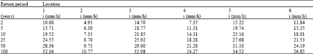
The rainfall depths required to apply Chen’s formula can be obtained from the frequency distributions for 1 and 24 h rainfall depths. The 10 year, 24 h and 100 year 1 h rainfall depths for each station are shown in Table 6.
When the three rainfall depths are known for each station, the Parameters a, b and c can be obtained from Chen[14]. For every station in the Mujib basin, the corresponding standard storm parameters are shown in Table 7.
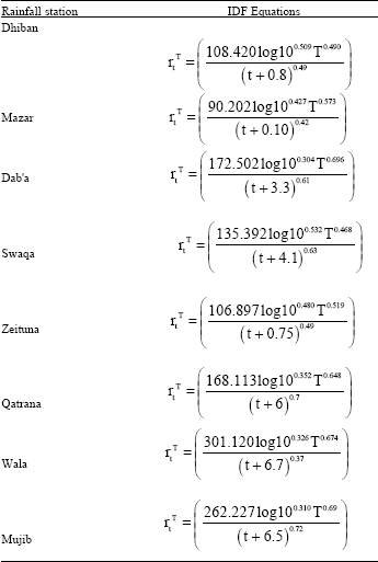
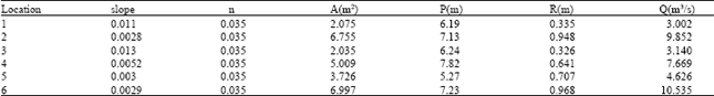
After the corresponding standard parameters are known, then the corresponding rainfall Duration-Intensity-Frequency (IDF) equations were presented as shown in Table 8. Peak discharges are found by applying rational method for six locations in the basin for return period 2, 5, 10, 25, 50, 100 years. The results are compared with those gotten by applying Manning equation for those locations after surveying the cross sections and bed slopes, these results are shown in Appendix A.
| Table 8: | IDF equation for each rainfall in the Mujib basin |
 | |
CONCLUSIONS
IDF equations for each of the 8 rainfall stations in the Mujib basin were obtained for duration varying from 5 to 1440 min and return period from 2 to 100 years. Water authority’s curves were compared with the corresponding equations obtained in this study for stations of (Dhiban, Mazar, Swaqa, Zeituna, Dab’a, Qatrana, Wala and Mujib rainfall station). Percent deviations were calculated by dividing the absolute differences between Gumbel values and values obtained in this study for the same duration and return period. The results predicted by the writer are closer to the measured values than those predicted by WAJ and by Gumbel method.
It may be conclude that the differences observed between the results of this study and the results of Gumbel’s method may be considered accepted and in good agreement; but there are a big differences between the results of this study and the study done by WAJ[3]; This can be attributed to the record lengths used by this study and WAJ study.
Appendix A
| Table A1: | The hydrological parameters that are necessary to analyse runoff discharges |
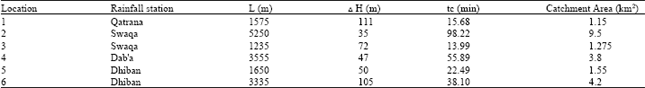 | |
| Table A2: | The rainfall intensities for return period 2, 5,10,25,50,100 years for 6 locations in the Mujib basin |
 | |
| Table A3: | The runoff discharges for return period 2, 5,10,25,50,100 years for 6 locations in the Mujib basin |
 | |
| Table A4: | The hydrological parameters that are necessary to calculate runoff discharges by using Manning equation |
 | |
It is noted that the relative error for 5 min duration for all stations is high in general between this study and WAJ[3] study; this is due to the fact that WAJ extrapolated their curves to include the 5 min duration, while in this study no extrapolation was made and only the formula obtained was applied. Moreover, some of the relative error was due to small values of reading, where small error will show high relative error.
An important advantage of this study is the ability of finding the rainfall intensity for durations less than 5 min directly by applying the equation for the station under study.
Peak discharges were calculated for selected locations in the Mujib basin; the calculations were done by using rational method: The results show that the maximum discharges are very close to the Manning’s equation at return period equal to 25 years.
REFERENCES
- Dillon, E.C., 1954. Analysis of 35-year automatic recordings of rainfall at Cork. Trans. Instit. Civil Eng. Ireland, 80: 191-216, 271-283.
Direct Link - Chen, C.L., 1983. Rainfall intensity-duration-frequency formulas. J. Hydraul. Eng., 109: 1603-1621.
CrossRefDirect Link - Bell, F.C., 1969. Generalized rainfall-duration-frequency relationships. J. Hydraul. Division, 95: 311-328.
Direct Link