
A.S. Fasina
Department of Crop, Soil and Environmental Sciences University of Ado-Ekiti, Nigeria
International Journal of Soil Science
Year: 2008 | Volume: 3 | Issue: 1 | Page No.: 35-41


ABSTRACT
A detailed soil survey of about 120.89 ha of land in Asu River Basin was carried out to evaluate the suitability of the soils for irrigation agriculture. The study revealed four (4) major soil types (Ihuibe 1 and Ihuibe 2, Ameta 1 and Ameta 2). The soils are deep (>100 cm) and contain low tolerable levels of calcium carbonate (EC-0.01 mmho cm-1 -0.22 mmho cm-1). Soil textures consist of loam (Ihuibe 1), sandy clay loam (Ihuibe 2), clay loam (Ametal 1) and loamy Sand (Ameta 2) on the surface to sandy clay loam (Ihuibe 1), clay loam (Ihuibe 2), sandy clay loam (Ameta 1) and clay (Ametal 2) subsoil. Three of the soils are imperfectly drained (Ihuibe 1, Ihuibe 2 and Ameta 2) while Ameta 1 is moderately well drained. The soils were classified into irrigation suitability classes for surface/gravity irrigation (Ihuibe 1 and Ihuibe 2 were classified as moderately suitable (S2) while Ameta 1 was classified as highly suitable (S1) and Ameta 2 as currently not suitable. For drip/localized irrigation, Ihuibe 1 and Ameta 2 were classified as moderately suitable (S2) while Ihuibe 1 and Ameta 1 were classified as highly suitable (S1). The study is recommending that for sustainable use of the area for irrigation agriculture, drip/localized type of irrigation should be used to irrigate the soils of the area.
PDF Abstract XML References Citation
How to cite this article
A.S. Fasina, 2008. Irrigation Suitability Evaluation of Asu River Basin Soils, South Eastern Nigeria. International Journal of Soil Science, 3: 35-41.
DOI: 10.3923/ijss.2008.35.41
URL: https://scialert.net/abstract/?doi=ijss.2008.35.41
DOI: 10.3923/ijss.2008.35.41
URL: https://scialert.net/abstract/?doi=ijss.2008.35.41
INTRODUCTION
It has been established that an efficient management of river basins will assist significantly in solving the problems of poor agricultural productivity in any country. To realize this fact, a lot of countries in the last decade had placed high premium on River Basin development. Agricultural projects under this scheme which involve arable crop production utilized mainly the flood plain and valley bottom soils and to some extent the adjoining upland. Unfortunately of late most of these river basins lies within regions where rainfall are often inadequate in amount and erratic in timing (Singh, 2000), thus necessitating irrigation in order to satisfy the moisture requirements of the crops needed to meet the demands for food and fiber.
Most of the river basin soils are productive, which necessitated their cultivation all year round to a host of high value agronomic and horticultural crops (Singh and Babaji, 1989). Farming on the River Basins depends on rains in the wet season (rice cultivation) and residual soil moisture in the dry season (Horticultural crops). To alleviate the problem of moisture stress during the prolonged gaps between rains as well as in the dry season, supplementary irrigation is provided by lifting the water from perennial surface water bodies, shallow wells and tube wells. Although the irrigation is useful for sustaining agricultural production in any locality, it is imperative that the soils to be use must be evaluated. If there is no proper land evaluation for irrigation agriculture technical problems may arise later that would affect both soil quality and crop production adversely.
Determining the suitability of land for irrigation requires a thorough evaluation of soil properties, the topography of the land within the field and the quality of water to be used for irrigation. Few researchers Akinbile et al. (2007), Adefisan et al. (2007) and Olowolafe and Patrick (2001) have all investigated on effective factors to be considered when evaluating soils for irrigation. irrigation systems and water supplies. A basic understanding of soil/water/plant interaction will help irrigator efficiently manage their crops, soils, irrigation systems and water supplies. Unfortunately published information on the properties of River basin soils is scarce.
Considering how large hectares of river basin soils which are agriculturally productive for irrigation agriculture within Nigeria and are mistakenly used for construction (residential and industrial), there is therefore the need to stop such a trend and conserve the river basin soils. Such river basin soils when fully harnessed and exploited can be used for irrigation agriculture in medium and large scale and will alleviate the present food shortage in the country and consequently alleviate poverty.
The potential uses of these soils are many and it is the objective of this research study to explore what is known about these soils with respect to their properties and their evaluation for irrigation land use. It is hoped that the information to be generated from this study will equip potential users with pedological information that is essential for the sustainable management of these soils for sustainable agriculture and environment within the study area.
Therefore, the major objective of this study is to evaluate the suitability of Asu river basin soils for irrigation agriculture. The result of this study is expected to serve as a guide in the choice of crops and management practice for different parts of the study area.
MATERIALS AND METHODS
Description of Study Area
The study areas are located in Anambra state (around Nsukka and Afikpo) in south eastern Nigeria. The approximate geographic coordinates are 6° 5I`N, 7° 23` E. These areas are located around the eastern part of the cross River and the area lies between Okposi and A fikpo. The area covers about 120.89 ha of land.
The climate of the basin lies within the humid, subtropical climate with distinct wet and dry season. The wet season spans from March to November and dry season from December to February. Means annual total rainfall ranges from 1800 to 2200 mm. The rainy season has two peaks (July and September) with a break in August. Temperature is generally high throughout the year with little deviation from the mean annual of 26 °C February-April as the hottest months. Humidity is high. The average index of mean relative humidity is never than 70%.
The geology of the Asu River Basin is dominated by shale which grades laterally into Amasiri sandstone. The vegetation of the area falls within the lowland rainforest zone and in the moist forest at low medium attitude zone. Land use around the area is basically agriculture. Crops such as Yam, Cassava, Maize, Cocoyam and Vegetable (Fluted pumpkins, Okro, red peppers, bitter leaf and melons) are grown.
Field Study and Laboratory Analysis
The major soil types were mapped using the approach developed by the soil survey manual (Soil Survey Staff, 2003). Four soil types were identified after the Rigid grid soil survey. Four soil profiles were dug and described according to the FAO (2006). Field descriptions and sample collections were made during the dry season to ensure freedom from groundwater disturbance.
Soil samples collected during the detailed soil survey investigation were air-dried and made to pass 2 mm sieve utilizing those that are less than 2 mm for laboratory analysis. The IITA procedures for soil and plant analysis (IITA, 1979) were followed in analyzing the soil samples.
Land Evaluation Procedure
Land Suitability for Irrigation
To evaluate the land suitability for irrigation the parametric evaluation system of Sys (1985) was applied, using soil and land characteristics. These characteristics concern environmental factors, drainage properties, soil physical and chemical properties. They are rated and used to calculate the suitability index for irrigation (Ci) according to the formula:
Ci = Ax B/100 xC/100xD/100xE/100xF/100 |
Where:
| Ci | = | Suitability index for irrigation |
| A | = | Soil texture rating |
| B | = | Soil depth rating |
| C | = | CaCO3 status: |
| D | = | Electro-conductivity rating |
| E | = | Drainage rating |
| F | = | Slope rating |
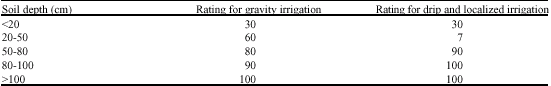
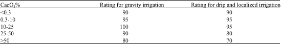
Suitability classes are defined considering the value of the suitability index (Table 1). For this study, gravity or surface irrigation that require impermeable soil with drip and localized irrigation and are less regarding to these characteristics were analysed. The soil characteristics were used according to different ratings specifying each type of irrigation (Table 2-7).
| Table 1: | Suitability index for the irrigation suitability indices (CI) Classes |
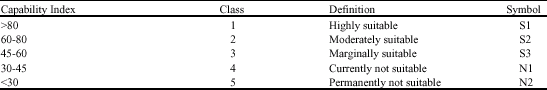 | |
| Source: Sys, 1995 | |
| Table 2: | Textural classes rating for irrigation suitability |
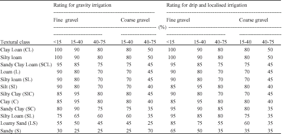 | |
| Source: Sys 1985 | |
| Table 3: | Soil depth rating for irrigation |
 | |
| Table 4: | CaCO3 status rating for Irrigation |
 | |
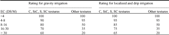
| Table 5: | Electro-conductivity rating for irrigation |
 | |
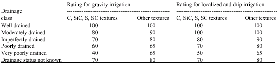
| Table 6: | Drainage classes rating for irrigation |
 | |
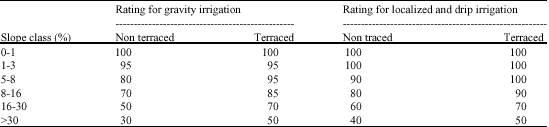
| Table 7: | Slope Rating for irrigation |
 | |
The data generated from the field for each pedon was then used to calculate the suitability index for irrigation (Ci) using the equation below for the four pedons.
Ci = A x B/100 C/100xD/100 x E/100x F/100 |
For example; to calculate the Ci (surface irrigation)for Ihuibe 1 using the equation we obtained the result as follow.
| Ci | = 90x100/100x100/100x100/100x80/100x95/100 = 90x1x1x0.8.0.95 = 68.4 |
Statistical analysis of the suitability rating for irrigation methods (surface and drip) was compared together using rank correlation coefficient to see whether there is a correlation between the two methods as evaluated for irrigation using Sys (1985) method. For rank correlation coefficient the formula used are
Where:
| d | = | Differences of pairs |
| n | = | No. of pairs |
RESULTS AND DISCUSSION
Land and Soil Characteristics of Study Area
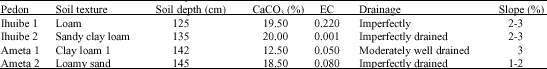
The summary of the Land and soil characteristics of the study area (pedons) is shown in Table 8. All the soils are deep (soil depth > 100 cm). This is good enough and will allow good penetration of roots of crops. For soil depth rating, all peonds were rated 100 for both surface (gravel) and drip irrigation (Table 9, 10). Soil depth refers to the thickness of the soil materials which provide structural support, nutrients and water for plants. The depth to a contrasting soil layer of sand and gravel can affect irrigation management decision if the depth to this layer is less than 3 feet, the rooting depth and available soil water for plants is decreased. Soils with less available water for plants require more frequent irrigations. The soil textures of the soils except Ameta 2 were considered good for surface (gravity) irrigation. However Ameta 2 soil texture was considered good for drip irrigation in spite of the loamy sand nature of the soil (Table 8) and it was rated 85% for suitability index for irrigation. Coarse textured soils such as sands and gravel usually have high infiltration rates. The infiltration rates of medium and fine textured soils such as loams, silts and clays are lower than those of coarse textured soils and more dependent on the stability of the soil aggregates. Water and plant nutrient losses may be greater on coarse textured soils, so the timing and quantity of chemical and water applications is particularly critical on these soils.
| Table 8: | Land and soil characteristics of pedons |
 | |
| Table 9: | Land and soil characteristics rating and capability index for drip/loc tlized irrigation of the pedons |
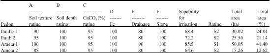 | |
| S1 = Highly Suitable, S2 = Moderately Suitable, N1 = Currently not Suitable, EC = Electrical conductivity (mmho cm-1) Ec = mmho cm-1 rating | |
| Table 10: | Land and characteristics rating and capability index for surface/gravity irrigation of the pedons |
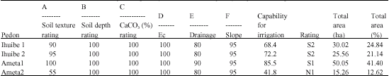 | |
| S1 = Highly Suitable, S2 = Moderately Suitable, N1 = currently not Suitable, EC = Electrical Conductivity (mmho cm-1), Ec = mmho cm-1 rating | |
When the CaCO3 (calcium carbonate) was rated all the soils were considered suitable for irrigation use. All the soils were rated 100 (Table 8, 9, 10). Electrical conductivity values for all the soils are low (Table 8). The values recorded for all the soils are less than 4 mm ho/cm –1 recommended as critical values for saline soils. Therefore there is no reason to be afraid that the soil might be saline. All the soils were rated 100 with reference to Electrical conductivity, meaning that all the soils are suitable for irrigation with reference to the salinity content of the soils
A large proportion of the soil (Ihuibe 1, Ihuibe 2 and Ameta 2) were imperfectly drained and were rated 90 (drip irrigation) and 80 (surface/gravity irrigation) for irrigation suitability. This is considered to be suitable for irrigation agriculture. With reference to slope all the soils were rated 95 (Table 10) for surface (gravity) irrigation. This is considered suitable for surface irrigation however when all the soils were rated for drip irrigation, they were found to be highly suitable (S1). This go to say slope may not be a critical factor in drip/localized irrigation when compared with surface irrigation because of erosion problem. Slope is important to soil formation and management because of its influence on runoff, soil drainage, erosion, use of machinery and choice of crops.
IRRIGATION SUITABILITY EVALUATION
The suitability of the soils was assessed for irrigation following the method of Sys 1985. The assessment of soils for irrigation involves the using of properties that are permanent in nature that cannot be change or modified without exorbitant cost. Such properties include depth, drainage, texture and slope. These properties are known to constitute some kind of hindrance to irrigation crop production. Chemical properties that are usually considered (e.g., fertility) can be changed with minor improvement.
The processing of the parametric evaluation system for gravity and drip/localized irrigation using the Sys (1985) method gave the irrigation suitability results in tables 9 and 10. From Table 10, 41.40% the area (Ameta 1) have been classified as highly suitable (S1) for surface irrigation about 45.97% of the study area (Ihuibe 1 and Ihuibe 2) are moderately suitable (S2) for surface irrigation. The limiting factor that lowers these soils to S2 is mainly the soil drainage status (Table 8). Also in some cases, the slope class also handicaps the use for surface irrigation purpose as seen in the case of soil of Ihuibe 1 and Ihuibe 2 (Table 8) with slope of 2-3%. Simple slopes of 1% or less are commonly used for gravity (Surface) irrigation. Simple and complex slopes greater than 1% should only be irrigated with sprinkler or drip systems. Center pivot sprinkler irrigation systems can operate on slopes up to 15% but simple slope greater than 9% are not generally recommended. To accommodate an irrigation application method such as gravity or sprinkler systems, the slope in a field can be modified by land smoothing. However, land smoothing may cause yield reduction for one to three growing seasons. The place where topsoil was removed are most likely to have yield reductions. Special management of these areas through increased fertilizer and organic matter application may be required for accelerated recovery.
About 12.62% of the study area (Ameta 2) is classified as currently not suitable (N1) for surface gravity irrigation. The limiting factor is mainly soil texture (Loamy sand) which was rated 55% for this soil. Soil texture is relevant to permeability, infiltration and water holding capacity of the soil. As we know water and plant nutrient losses may be greater on coarse textured soils, so the timing and quantity of chemical and water applications is particularly critical on these soils. Surface irrigation requires heavier soils. For drip and localized irrigation (Table 9), a good proportion (41.40%) of the area (Ameta1) are highly suitable (S1) while 58.60% of the area (Ihuibe1, Ihuibe2 and Ameta2) are classified as moderately suitable (S2). The Ameta 2 that was classified as currently not suitable (N1) under surface irrigation is now classified as moderately suitable (S2) for drip/Localized irrigation. This is because soil texture is not regarded as a critical factor for drip irrigation. The agreement between surface and drip irrigation suitability rating was compared using rank correlation. The results show that the two was significant with R value of 0.60 (p<0.01).This shows that there is agreement in the rating ability of the Sys (1985) method of rating the soils for irrigation agriculture.
The comparison of the two types of irrigation revealed that it would be more beneficial to irrigate by drip or localized type, as the latter mode improves all the suitability to the irrigation purposes (e.g., the Ameta 2 Soil). The drip irrigation is recommended for a sustainable use of this natural resource.
CONCLUSIONS AND RECOMMENDATIONS
An irrigation evaluation of soils of Asu River Basin was carried out. The result obtained reveals that the soils are suitable for both surface/gravity and drip/localized irrigation at various rating levels (Highly and moderately suitable). The parameters investigated (Soil texture, soil depth, CaCO3, Electrical Conductivity (EC), Soil Drainage and Slope) all fall within the tolerable limit for irrigation purpose. As a result of the agricultural potential of these soils (River Basin soils), the land should therefore be conserved when not in use against permanent use e.g., residential, building and industrial uses. With the current potential of these soils for irrigation, if fully harnessed and properly utilized, it will increase crop productivity and consequently alleviate poverty.
From the result of the study, the following recommendations are suggested
| • | It is better to irrigate the land using the drip/localized method since it improves the suitability to the irrigation purposes and also ensure the sustainable use of the land for irrigation agriculture. |
| • | As a result of the competing demand of land for agriculture urban and other land use activities within the study area, land use plan is therefore necessary to conserve and protect this suitable agricultural land against other land uses. |
| • | The quality of water to be use for irrigating |
the soils must be evaluated appropriately. Further studies can be carried out on water quality requirement for irrigation agriculture for this area.
REFERENCES
- Adefisan, E.A., S.O. Gbuyiro and J.O. Bayo, 2007. Development of irrigation requirement and water scheduling model for West Africa. Agric. J., 2: 577-582.
Direct Link - Akinbile, O.C., A.Y. Sangodoyin, I. Akintayo, F.E. Nwilene and Futakuchi, 2007. Growth and yield responses of upland Rice (NERICA 2) under different water Regimes in Ibadan, Nigeria. Res. J. Agron., 1: 71-75.
Direct Link - Olowolafe, E.A. and S. Patrick, 2001. Land evaluation for irrigated agriculture in a semi-arid area of Northern Nigeria. Nig. J. Soil Res., 2: 1-7.
Direct Link