
Mohammed A. Al-Fredan
College of Science, King Faisal University, P.O. Box 5234, Al-Hassa-31982, Kingdom of Saudi Arabia
International Journal of Botany
Year: 2008 | Volume: 4 | Issue: 2 | Page No.: 196-204


ABSTRACT
A study was conducted during 2006 and 2007 in Eastern Saudi Arabia to provide the needed information about the vegetation of sand dunes and sabkhas in the region and to provide insight into the factors controlling community distribution. Eastern Saudi Arabia with arid climatic conditions has sparsely distributed sand dune and sabkha vegetation cover. The vegetation comprises of perennial herbs, dwarf shrubs and few tree species. Seven major plant communities were recognized according to their dominant and co-dominant species: Panicum turgidum-Stipa capensis, Panicum turgidum-Pennisetum divisum, Panicum turgidum-Zygophyllum coccineum, Lasiurus scindicus-Stipagrostis plumose, Aeluropus lagopoides-Halopeplis perfoliata, Tamafix arabica-Aeluropus lagopoides and Zygophyllum coccineum-Cyperus conglomeratus. The seven communities represented different combinations of species. Soil organic carbon, soil salinity and soil water holding capacity appear to have a substantial influence on determining vegetation composition and abundance. In general, there are 45 species in the study area differing in their relative abundance, frequency and richness.
PDF Abstract XML References Citation
How to cite this article
Mohammed A. Al-Fredan, 2008. Sand Dune and Sabkha Vegetations of Eastern Saudi Arabia. International Journal of Botany, 4: 196-204.
DOI: 10.3923/ijb.2008.196.204
URL: https://scialert.net/abstract/?doi=ijb.2008.196.204
DOI: 10.3923/ijb.2008.196.204
URL: https://scialert.net/abstract/?doi=ijb.2008.196.204
INTRODUCTION
Species diversity is closely related to ecosystem stability (Johnson et al., 1996; Tilman and Downing, 1994; McNaughton, 1997; Tilman, 2000). Studies on species diversity have focused on the changes in species quantity and the degree of biodiversity. Many studies recorded changes of species diversity with water availability (Casper, 1996). However, information is still lacking on the relationship between salinity and species diversity, especially for the arid regions. Sand dune and Sabkha vegetations, mostly composed of halophytes are common throughout Eastern Saudi Arabia (Shaltout et al., 1997). The halophytic flora is mainly composed of perennial grasses, shrubs and some annuals associated with saline environments (Mandaville, 1990).
Sabkha is characterized by a shallow underground water table, in certain instances; the underground water is exposed forming lakes of saline water. The vegetation has a patchy structure, with different clusters containing different species and even different growth forms (Shaltout et al., 1997). The sand adapted species tend to recur through the sand zones, but become increasingly sparse as the dunes build up. To survive, the plants need to be able to grow through the accumulating sands and also to possess long root systems to reach down to the water. These coastal sands often overlie sabkha and although these flats have no vegetation themselves, their sandy borders are colonized by low growing halophytes with fleshy leaves, which form low green mats around the sabkha’s edge (Abd El-Ghani, 1998).
Some detailed vegetational studies have been published in the neighboring countries of Kuwait (Halwagy and Halwagy, 1974a, b), Iraq (Thalen, 1979) and Qatar (Batanouny, 1981; Abdel-Razik and Ismail, 1990; Babikir and Kiltschner, 1992). A general description of the vegetation of the Eastern Arabia has been given by Vesey-Fitzgerald (1957). Except the floristic studies conducted by Collenette (1998), Migahid (1990) and Mandaville (1990), a detailed account of the vegetation of the region with special emphasis to dune systems and sabkha systems are seldom attempted (Shaltout et al., 1997).
The availability of water is one of the primary factors controlling the distribution of species (Noy-Meir, 1973). The most critical gradients in a biotic factor may be related to water availability, soil properties and topography (Parker, 1991). Correlation of soils and vegetation are important for most investigations of plant habitats. Olsvig-Whittaker et al. (1983), Stahr et al. (1985) and Abd El-Ghani (1997, 1998, 2000) worked in this direction. These investigations covered large areas and thus reported striking gradients referring to soil conditions and vegetation.
A number of diversity indices (α-diversity was to measure the diversity within a community, α-diversity to determine inter-community diversity) have been used for determining plant species diversity (Poschlod et al., 1998; de Clercq et al., 2006). Shannon-Weaver index of diversity gives a numerical value of the diversity based on the total number of species (species richness) and the proportion of individual (evenness) in the ecosystem. Although these indices give an idea of the number and distribution of the individuals of the species in a community, it does not account for the extent of variability among the species and their distribution.
Studies identifying the major environmental factors associated with vegetation patterns in the sand dune and sabkhas in Eastern Saudi Arabia are scarce. The objective of this study was to throw light on the vegetation of sand dune and sabkha areas in the Eastern Saudi Arabia and to make environmental measurements to provide information about factors controlling community distributions.
MATERIALS AND METHODS
Study area: Eastern Saudi Arabia (Fig. 1) consists of a broad, flat, low coastal plain that is covered with sand and gravel. The country’s largest and most fertile oasis is located here, around Al-Hofuf. Almost the entire eastern region has a desert climate, with scanty, unreliable rainfall and extremely hot diurnal temperatures for many months of the year. The daily and seasonal range of temperature is large, particularly in the areas away from the coast. In the summer, maximum temperature in the interior often reaches 45°C. In winter temperatures in the interior are mild during the day (20°C) but often fall below freezing at night. Between October and May climate is generally pleasant with cool nights and sunny days. Long spells of drought, sometimes ranging between 2-4 years, are experienced in this region. The only source of water is that available 4-120 m below soil surface but this is highly saline. Under these conditions, naturally growing plants are frequently damaged by drought. The coastal regions are notorious for their oppressive humidity as well as heat. The northern part of the region receives less than 25 mm of rain annually, while the southern part receives even less rain falls than the north.
The coastal border is extremely irregular, consisting of emerging sandy plains, marshes and salt flats almost imperceptibly with the sea. As a result, the land surface is unstable in the places where water raises almost to the surface and the sea is shallow with shoals and reefs extending far offshore.
Because of its extreme aridity the eastern region rely heavily on groundwater. Fortunately, artesian wells and springs are plentiful in Al-Hassa region. This region is covered with grass and the vegetation supports a nomadic and semi nomadic herding population. In the areas where there is little ground cover, northwesterly blown winds, during most of the summer months cause violent sandstorms.
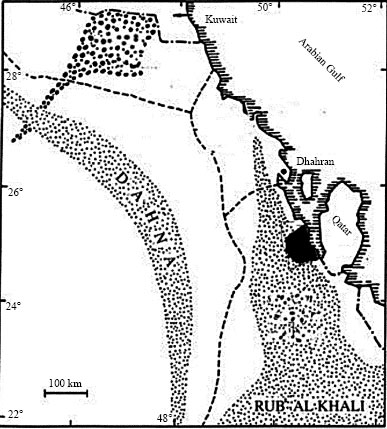 | |
| Fig. 1: | The study area |
Sampling: Sand dunes and Sabkha sites in the study area were surveyed during springs of 2006 and 2007 for vegetation variations. One hundred quadrates (1x1 m) were established over sand dune and Sabkha sites. Soil samples were taken to a depth of 15 cm from each quadrate and samples were analyzed for texture (sand, silt and clay) by Bouyoucus Hydrometer and organic matter by the Walkley-Black method (Black, 1979). The soil was analyzed for pH and electrical conductivity by pH and conductivity meters on water extract basis (1:2.5). Water content was determined by loss-on-drying at 80°C.
Within each quadrate, species present were recorded. The latest of taxonomic nomenclature of plant names have been followed (Collenette, 1998). Number of individuals per unit area (density), height of plants and number of species per quadrate were recorded. Plant cover was estimated quantitatively by the line intercept method (Canfield, 1941). For this purpose, 10 parallel lines each 10 m apart were laid down in each site.
A quantitative survey of the vegetation was carried out during 1999-2000. Pearson’s correlation coefficient is calculated to evaluate the relationship between the soil factors. Species richness of the vegetation stand was calculated as the mean number of species per stand. Plant species abundance, vegetation coverage, plant height, was also measured.
Plant species diversity was assessed by measuring the abundance and uniformity of species in the plant communities or habitats. The species abundance refers to the quantity of species in the community, while the species uniformity refers to the distribution of individuals of all species in a community.
The importance value was calculated as:
where, Cr, is the relative coverage; Dr, the relative density and Hr, the relative height of plants.
The species diversity index (Shannon-Weaver index) and the species richness index (Margalef index), were calculated using the following formulas:
Shannon-Weaver index: ![]()
Margalef index:
where, Pi = the relative importance value of the species i, N = the sum of importance values of all species on a site where species i is found and S the total number of species as according to Margalef (1958) and Whittaker (1972).
The two species with the highest importance values were recognized as the dominant and co-dominant ones (Sagar et al., 2008).
RESULTS AND DISCUSSION
Soil conditions: The area is generally covered by sands and salt crusted flats. ’Sabkhas’, are common especially in the coastal areas of the Arabian Gulf. A Sabkha surface is leveled and sometimes covered with salts caused by the capillary rise of shallow ground water. The salts are later dissolved when the surface is flooded or washed by rain. Sabkhas are nearly devoid of higher plants except for halophytes (Mandaville, 1990). Most of the sand dunes in the study area are fixed and support good vegetation, but nearly barren, unstabilized sand dunes were also present.
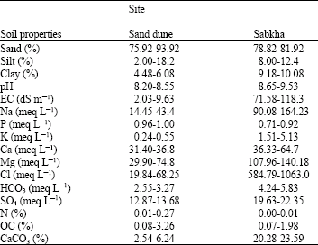
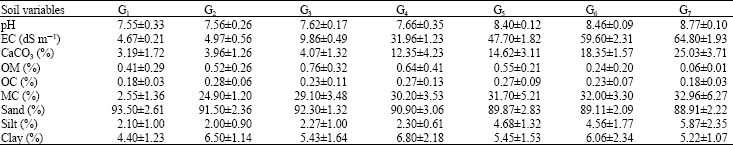
The soils in the stable and unstable dunes were sandy and the content of silt and clay particles was only appreciable in the inner dune depressions. These soils are coarse in texture and as a consequence of the scarcity of organic matter, the high Na content (14.45-43-84 meq L-1) and the sandy texture; the soils were alkaline with a pH range of 8.20-8.55. Salinity was higher at inter-dune depressions due to shallow saline water table and the increased electrical conductivity was linked to increased Cl-, SO42-, Na+ and Mg2+ ions. The inter-dune depressions were markedly affected by the capillary, upward movement of saline water. The electrical conductivity in these depressions was ranged between 2.03-9.63 dS m-1. The soils lacked carbonates but they were rich in other exchangeable bases. The Organic Carbon (OC) content was very variable, with values between 0.08-3.26% (Table 1). Soils at the inter-dune depressions generally had higher OC content than soils at the summit position; this may be due to the fact that more dense vegetation covers in the former (Rhao and Pathak, 1996). Most of the soil samples showed low nitrogen contents (0.03%) and CaCO3 content ranged between 2.54 and 6.24%.
| Table 1: | Physical and chemical properties of soil |
 | |
| Table 2: | Pearson correlation®< between soil parameters in the study area |
 | |
| *p<=0.05, **p<=<0.01 | |
| Table 3: | Family composition of the vegetation in the study area |
 | |
Sabkhas are generally of evaporative formation, either from sea invasion or from seepage of moisture from low-laying strata. In both cases varying quantities of CaCO3, MgCO3, CaSO4 and CaCl2, MgCl2 and NaCl were present in the soil. Sabkha soils were also sandy (78.8-81.9% sand, 8.0-12.4% silt and 8.5-10.1% clay) with an organic carbon content of 0.81 to 1.98%. pH values ranged between 8.65 and 9.53, while EC ranged between 71.58 and 82.3 dS m-1. The rise in electrical conductivity was linked to an increased Na+ (90-08-164.23 meq L-1), Mg++ (107.96-140.18 meq L-1), Cl- (584.79-1063 meq L-1) and SO4- (19.63-22.35 meq L-1) ions (Table 1). The nitrogen content was very meager and CaCO3 content ranged between 20.28 and 23.59%.
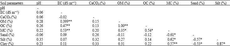
Pearson correlation between soil parameters (Table 2) showed that significant correlation occurred between the soil moisture content, organic matter, organic carbon and EC and between organic matter, organic carbon and moisture content. A positive correlation was also observed between soil moisture content and fine soil fraction (silt and clay). However, a negative significant correlation existed between soil moisture content and its sand content.
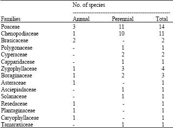
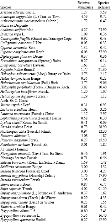
Species distribution and composition: A total of 45 species were recorded in the 100 quadrates, on a total area of 0.5 ha. The family Poaceae had the greatest number of species (14) followed by the family Chenopodiaceae (11). Nine families were represented by a single species each (Table 3).
The cluster analysis is interpreted at the general level of two community types (1. sand dunes: inactive sand dunes which are stabilized by vegetation and active sand dunes which are wind blown but covered by protective vegetation, 2. Sabkha). The vegetation of the two sites in the study area was classified using TWINSPAN into seven communities, each community representing a specific plant cluster according to the dominant and co-dominant species that reach the highest cover values. The vegetation is generally xerophytic in nature. The distribution of the vegetation is mainly controlled by the edaphic and climatic factors in the area.
Out of the seven communities identified by the TWINSPAN analysis three were belonging to the sand dune vegetation and four were belonging to sabkha vegetation.
Sand dune site vegetation with their importance values of species in parenthesis.
| G1. | Panicum turgidum (39.7), Stipa capensis (15.6) which includes Haloxylon salicornicum (5.32), Cyperus conglomeratus (9.41), Aristida adscensionis (3.65), Tamarix arabica (1.09), Stipagrostis cliata (2.34), Stipagrostis drarii (1.97), Panicum albicans (1.82), Zygophllum coccineum (1.76), Panicum turgidum (39.7), Stipa capensis (15.6). |
| G2. | Panicum turgidum (27.1), Pennisetum divisum (6.93): which includes Reseda arabica (5.82), Heliotropium bacciferum (4.82), Leptadenia pyrotechnica (3.79), Haloxylon persicum (3.44), Heliotropium digynum (3.11), Lycium shawii (1.12), Plantago boissier (0.93), Zygophllum coccineum (0.87), Tamarix arabica (0.84), Panicum turgidum (27.1), Pennisetum divisum (6.63). |
| G3. | Lasiurus scindicus (12.35), Stipagrostis plumose (9.48): which includes Cyperus conglomeratus (8.86), Moltkiopsis cilita (0.95), Tamarix arabica (0.86), Cyperus arenarius (2.72), Centropodia fragilis (2.68), Pennisetum divisum (7.36), Dipterygium glaucum (0.17), Zygophyllum coccineum (0.15), Panicum turgidum (5.48), Reseda arabica (3.12), Heliotropium bacciferum (2.36), Lycium shawii (1.69), Eremobium aegyptiacum (1.13), Lasiurus scindicus (12.35), Stipagrosis plumose (9.48). |
Sabkha site vegetation with their importance values of species in parenthesis.
| G4. | Panicum turgidum (10.1); Zygophyllum coccineum (5.49): which includes Halocnemum strobilaceum (5.12), Halopeplis perfoliata (4.56), Tamarix arabica (1.31), Arthocnemum macrostachum (4.09), Suaeda aegyptiaca (2.41), Panicum turgidum (10.1), Zygophyllum coccineum (5.49). |
| G5. | Aeluropus lagopoides (8.69); Halopeplis perfoliata (4.87): which includes Panicum turgidum (3.01), Halocnemum strobilaceum (2.39), Arthocnemum macrostachyum (1.72), Tamarix arabica (1.53), Seidlitzia rosmarinus (1.46), Zygophyllum coccineum (2.12), Aeluropus lagopoides (8.69), Halopeplis perfoliata (4.87). |
| G6. | Tamarix arabica (6.88); Aeluropus lagopoides (3.68): which includes Halocnemum strobilaceum (3.38), Seidlitzia rosmarinus (3.01), Zygophyllum coccineum (2.49), Suaeda fruticosa (2.46), Suaeda egyptiaca ((2.39), Phragmites australis (1.28), Juncos rigidus (0.16), Zygophyllum coccineum (2.94), Tamarix arabica (6.88), Aeluropus lagopoides (3.68). |
This group is mainly present in the highly saline edges of sabkha. A. lagopoides is a good indicator of saline soil (Shaltout et al., 1997).
| G7. | Zygophyllum coccineum (5.92); Cyperus conglomeratus (3.28): which includes Anabasis setifera (2.08), Suaeda fruticosa (2.08), Zygophyllum qatarense (1.90), Tamarix arabica (2.38), Suaeda vermiculata (1.62), Seidlitzia rosmarinus (1.08), Platago boissier (0.85), Launaea capitata (0.08), Zygophyllum coccineum (5.92), Cyperus conglomeratus (3.28). |
The seven communities represented different combinations of species with different dominant and co-dominant species. Thus, each sand dune or Sabkha site produced characteristic species composition. Most of these species are salt tolerant plants. Vesey-Fitzgerald (1957) classified the whole group of perennials in the eastern region of Saudi Arabia as halophytes. It appears that soil organic carbon, soil salinity and soil water holding capacity had a substantial influence on determining vegetation composition.
The number of species across the study sites varied from 1 to 9 per quadrate and the number of individuals varied from 1 to 31 per quadrate. The number of individuals for various species in the entire study area varied from 1 to 1200 per 0.5 ha. The majority of species were represented by very few individuals and this number varied among sites. The presence of a greater number of species and individuals in few quadrates indicated an uneven distribution of species and individuals. This uneven distribution partly reflects variability of soil salinity in the study area, due to the presence of a clear salinity gradient from the coastal sand dunes to the interior where Sabkha sites are present.
The presence of Panicum turgidum, Halocnemum strobilaceum, Zygophyllum coccineum and Tamarix arabica at all sites along the salinity gradient suggest their resistance to variability in soil characteristics. The reduction in the number of species in response to climatic and edaphic factors as well as grazing practices changes the habitat fitness for many species (Pandey and Shukla, 1999).
Several studies have provided qualitative assessments of the distribution of plant species in relation to physiographic factors in different areas of the Eastern region of the Kingdom of Saudi Arabia (Migahid, 1990; Mandaville, 1990; Vesey-Fitzgerald, 1957). The approaches in all those studies were to provide a subjective description of ecological conditions based on the field experience.
Soil characteristics of each of the seven vegetation communities are summarized in Table 4 for the measured soil parameters, pH, EC, CaCO3, sand, silt, clay and soil saturation showed highly significant differences between groups.
The relative abundance and species richness are presented in Table 5. Five communities have relative abundance > 5: P. turgidum (6.27), C. conglomerates (6.05), H. strobilaceum (5.75), Z. coccineum (5.35) and P. albicans (5.08). Seven have relative abundance in the range of 3-5: A. setifera (4.27), S. capensis (4.02), S. vermiculata (3.98), H. perfoliata (3.82), P. divisum (3.01), S. fruticosa (3.00), S. rosmarinus (3.00), while 33 species have relative abundance < 3.0.
| Table 4: | Mean values and standard deviation of the soil variables in the site representing the seven vegetation communities obtained by TWINSPAN |
 | |
| Table 5: | Relative abundance and species richness values of plant species in the study area |
 | |
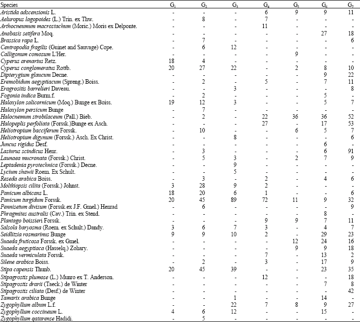
Frequencies of species in the seven communities are presented in Table 6. Some species occur in one community such as A. macrostachyum, C. comosum, H. persicum, J. rigidus and P. anstralis, while others occur in not less than three communities e.g., A. lagopoides, C. conglomerates, L. pyrotechnica, L. shawii, H. strobilacenum, H. pertoliata, H. salicornicum, H. bacciferman, L. scindicus, L. mucronate, M. ciliata. P. turgilum, P. albicans, P. arabica, S. baryosma, S. rosmarinus, S. arabica, S. capensis, S. fruticosa, S. vermiculata and Z. coccineum.
The vegetation distribution pattern in the study areas was mainly related to gradients in salinity, soil moisture and fine fraction. Concentration of calcareous deposit was also important. The distribution of species in saline habitats which relates to salinity in arid regions has been reported by Caballero et al. (1994) and Maryam et al. (1995). They stated that the distribution of halophytes is mainly dependent on the salinity gradient, while climate, topography, soil moisture and biotic factors are less important. Zahran et al. (1996) demonstrated that the distribution of some halophytic species is best correlated along a gradient of soil variables, such as salinity, moisture content, soil texture, organic matter and calcium carbonate. However, the role of ecological factors varies between different ecosystems. In the present study, soil salinity and its variation from sand dune to sabkha sites is the main cause of the plant community structure. The role of soil moisture as a key element in the distribution of the plant species in sand dune and sabkhas is cited by El-Sheikh and Yousef (1981) and El-Sheikh et al. (1985) and Winter (1990).
Species richness has been described in this paper by two different ways, namely the total number of species and the Shannon-Weaver index in each sampling quadrate for comparing α-diversity level of different vegetation clusters. The species richness (Margalef index), species evenness (whittakers index) and species diversity (exponential Shannon-Wiener index) declined with the increase of soil salinity (Table 7).
Low levels of plant species diversity were found for the studied sites: the Shannon-Weaver index was in the range between 0.53 and 1.93, while the Margalef index ranged between 0.91 and 7.28. There were apparent trends of decreasing values in the above indices with the increase in salinity level from G1 to G7.
| Table 6: | Frequency of species in the seven communities |
 | |
| Table 7: | Patterns of species diversity along the salinity gradient in Eastern Saudi Arabia |
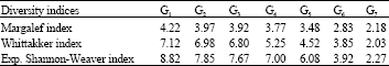 | |
The relationship between salinity and both the Shannon-Weaver index and number of species was linear. Data in Table 6 shows that species richness varies from one vegetation type to another. The Shannon-Weaver index shows that the lowest value appears in the community G7 that is dominated by Zygophyllum coccineum and the highest two are in communities G1, G2 and G3. This coincides with sites in sand dune areas where salinity is lowest.
Species richness is one of the most fundamental factor of biodiversity (Zechmeister and Moser, 2001) and the biodiversity pattern at the species level is therefore very important for biodiversity conservation. However, a complete species list with the information about the distribution of each species in the Eastern region of Saudi Arabia is lacking and a detailed survey on the flora of the region is limited due to lack of time and funds.
ACKNOWLEDGMENT
King Faisal University, College for Graduate studies and Scientific Research is acknowledge for financial support.
REFERENCES
- Abd-el-Ghani, M.M., 1997. Vegetation analysis and species diversity along an altitudinal gradient in the central Hijaz Mountains of Saudi Arabia. Arab Gulf J. Sci. Res., 15: 399-414.
Direct Link - Abd-El-Ghani, M.M., 1998. Environmental correlates of species distribution in arid desert ecosystems of Eastern Egypt. J. Arid Environ., 38: 297-313.
CrossRefDirect Link - Abd-El-Ghani, M.M., 2000. Floristics and environmental relations in two extreme desert zones of Western Egypt. J. Global Ecol. Biogeogr., 6: 499-516.
CrossRefDirect Link - Abdel-Razik, M.S. and A.M.A. Ismail, 1990. Vegetation composition of a maritime salt march in Qatar in relation to edaphic factors. J. Veg. Sci., 1: 85-88.
CrossRefDirect Link - Canfield, R.H., 1941. Application of the line interception method in sampling range vegetation. J. For., 39: 288-294.
Direct Link - Casper, B.B., 1996. Demographic consequences of drought in the herbaceous perennial Cryptantha flava: Effects of density, associations with shrubs and plant size. Oecologia, 106: 144-152.
CrossRefDirect Link - Collenette, S., 1998. A Checklist of Botanical Species in Saudi Arabia. 1st Edn., International Ascale Paid Society, Burgess Hill, England, ISBN: 0953237605, pp: 80.
Direct Link - de Clercq, E.M., F. Vandemoortele and R.R. de Wulf, 2006. A method for the selection of relevant pattern indices for monitoring of spatial forest cover pattern at a regional scale. Int. J. Applied Earth Observ. Geoinform., 8: 113-125.
CrossRef - Halwagy, R. and M. Halwagy, 1974. Ecological studies on the desert of Kuwait. II. The vegetation. J. Univ. Kuwait (Sci.), 1: 87-95.
Direct Link - Johnson, K.G., K.A. Vogt, H.J. Clark, O.J. Schmitz and D.J. Vogt, 1996. Biodiversity and the productivity and stability of ecosystems. Trends Ecol. Evol., 11: 372-377.
CrossRefDirect Link - Mandaville, J.P., 1990. Flora of Eastern Saudi Arabia. 1st Edn., Kegan Pual Int. Ltd., London, UK., ISBN-13: 9780710303714, Pages: 482.
Direct Link - Maryam, H., S. Ismail, F. Ala and R. Ahmed, 1995. Studies on growth and salt regulation in some halophytes as influenced by edaphic and climatic conditions. Pak. J. Bot., 27: 151-163.
Direct Link - McNaughton, S.J., 1997. Diversity and stability of ecological communities: A comment on the role of empiricism in ecology. Am. Nat., 111: 515-525.
CrossRefDirect Link - Noy-Meir, I., 1973. Desert ecosystems: Environment and producers. Ann. Rev. Ecol. Syst., 4: 25-51.
CrossRefDirect Link - Olsvig-Whittaker, L., M. Shachak and A. Yair, 1983. Vegetation patterns related to environmental factors in a Negev Desert watershed. Vegetatio, 54: 153-165.
CrossRefDirect Link - Pandey, S.K. and R.P. Shukla, 1999. Plant diversity and community patterns along the disturbance gradient in plantation of sal (Shorea robsuta Gaertn). Curr. Sci., 77: 814-818.
Direct Link - Parker, K., 1991. Topography, substrate and vegetation patterns in the Northern Sonoran Desert. J. Biogeogr., 18: 151-163.
CrossRefDirect Link - Poschlod, P., S. Kiefer, U. Trankle, S. Fisher and S. Bonn, 1998. Plant species richness in calcareous grasslands as affected by dispersability in space and time. Applied Veg. Sci., 1: 75-91.
CrossRefDirect Link - Rhao, D.L.N. and H. Pathak, 1996. Ameliorative influence of organic matter on biological activity of salt‐affected soils. Arid Soil Res. Rehabilit., 10: 311-319.
CrossRefDirect Link - Sagar, R., A.S. Reghubanshi and J.S. Singh, 2008. Comparison of community composition and species diversity of understorey and overstorey tree species in a dry tropical forest of Northern India. J. Environ. Manage., 88: 1037-1046.
CrossRefDirect Link - Shaltout, K.H., E.F. El-Halawany and M.M. El-Garawany, 1997. Coastal lowland vegetation of Eastern Saudi Arabia. Biodivers. Conservat., 6: 1027-1040.
CrossRefDirect Link - Thalen, D.C.P., 1979. Ecology and Utilization of Desert Shrub Randelands in Iraq. 1st Edn., Dr. W. Junk B.V. Publishers, The Hague, Netherlands, pp: 448.
Direct Link - Tilman, D. and J.A. Downing, 1994. Biodiversity and stability in grasslands. Nature, 367: 363-365.
CrossRefDirect Link - Tilman, D., 2000. Causes, consequences and ethics of biodiversity. Nature, 405: 208-211.
CrossRefPubMedDirect Link - Vesey-Fitzgerald, D.F., 1957. The vegetation of the central and Eastern Arabia. J. Ecol., 45: 779-798.
Direct Link - Whittaker, R.H., 1972. Evolution and measurement of species diversity. Taxon, 21: 213-251.
CrossRefDirect Link - Winter, E., 1990. Characteristics and distribution of halophytes at a Jordanian saltpan. Flora, 184: 341-367.
CrossRefDirect Link - Zechmeister, G.H. and D. Moser, 2001. The influence of agricultural land-use intensity on bryophyte species richness. Biodiver. Conserv., 10: 1609-1625.
CrossRefDirect Link