
E. U. Onweremadu
Department of Soil Science and Technology, Federal University of Technology, Pmb 1526 Owerri, Nigeria
International Journal of Agricultural Research
Year: 2007 | Volume: 2 | Issue: 6 | Page No.: 552-558


ABSTRACT
Variability of soil carbon in 5 floodplain soils at landscape scales were studied. Transect technique was used in soil sampling at 0, 25, 50, 75 and 100 m sampling points. Results showed that some measured soil properties varied among floodplain soils although all locations belong to the rainforest agro-ecology. The Oa horizons accounted for the highest variability in thickness (CV = 26%) in some locations. There was significant variation in total soil carbon in 60% of the floodplain soils. It is concluded that intensive soil sampling from landscape delineations will provide more accurate and reliable representation of soil carbon for scaling at regional levels.
PDF Abstract XML References
How to cite this article
E. U. Onweremadu, 2007. Spatial Variability of Soil Carbon in Floodplain Soils of Southeastern Nigeria. International Journal of Agricultural Research, 2: 552-558.
DOI: 10.3923/ijar.2007.552.558
URL: https://scialert.net/abstract/?doi=ijar.2007.552.558
DOI: 10.3923/ijar.2007.552.558
URL: https://scialert.net/abstract/?doi=ijar.2007.552.558
INTRODUCTION
Periodic assessments of the distribution of soil carbon within and among soils are critical to developing an understanding of the cause and effect relationships between climate or land use change and release of carbon (IV) oxide to the atmosphere (Schimel et al., 1994). In addition to understanding the cause and effect relationship, knowledge of soil organic carbon spatial variability is critical when developing carbon budgets for basic ecosystem characterization (Davis et al., 2004).
The magnitude of Soil Organic Carbon (SOC) pool is a product of complex interactions among climate, topography, texture and land-use practices (Pennock and Kessel, 1997; Tan et al., 2003). Because of the strong influence of climate on SOC dynamics, a greater precision may be achieved if monitoring is conducted within the region containing similar climate conditions (Brejda et al., 2001).
Geospatial and temporal changes occur in soil carbon distribution in floodplains. Variabilities are attributed to changes in temperature, precipitation, plant succession or local depositional factors (Marion and Oechel, 1993). Bockheim et al. (2004) reported spatial variability of SOC pools with relative basin age class and attributed this to increased variability in hydrological enrichments.
In USA, some regional studies on estimation of SOC pools using pedon data have been conducted as a part of the USDA-NRCS Progressive Soil Survey (Kern, 1994; Grossman et al., 1998; Homann et al., 1998). Although the national soil survey database in USA is quite comprehensive, additional data on the of O horizons and subsoils of forest soils to the carbon pool were reported (Eswaran et al., 1993). Such regional studies are scanty in developing countries and where available consider too many soil properties. This study is aimed at investigating the degree of variation occurring in floodplain soils in lowland areas of southeastern Nigeria.
MATERIALS AND METHODS
Study Site
The research was focused on 5 floodplain soils along Imo River, Mmahu Egbema River and Oguta Lake in southeastern Nigeria. The watershed area is over 14500 km2 and dominated by alluvial landforms, especially levee, backswamp, terrace and crevasse splay of recent necocene age (Ofomata, 1975). This formation is partly marine, partly deltaic, partly estuarine, partly lagoonal and fluviolacustrine in origin (Orajaka, 1975). The site has a bimodal rainfall pattern with a mean annual rainfall greater than 2500 mm (Obi and Salako, 1995). Mean monthly temperature is about 28°C. Rainforest vegetation predominates in these lowland areas although altered slightly by anthropogenic activities. Farming, hunting and fishing are the major socioeconomic activities of the area. Farmers raise mounds to avoid seasonal waterlogging.
Studies conducted at a scale of 1:500,000 classified soils of the area as Typic Udipsamments (Akwette), Typic Hapludults (Egbema), Typic Paleudults (Mbaise), Arenic Paleudults (Oguta) and Arenic Paleudults (Owerrinta) with an altitude below 100 m in all locations (Onweremadu, 2006).
Field Sampling
Land units were delineated based on the 5 physiographic features, namely near upland hillwash, terrace, levee and backswamp. Soils were collected along two randomly chosen transects within each of the 5 delineations according to the procedure of Young et al. (1991). Sampling locations were spaced at 25 m intervals for a total of five sampling points, that is, 0, 25, 50, 75 and 100 m per transect. Samples for each location were collected by horizon to a depth of 100 cm. Organic horizon samples were collected from a 15 by 15 cm area intact and separated into fibric (Oi), hemic (Oe) and sapric (Oa) horizons using peat samples. Composite samples were produced by bulking collected samples from each pedogenic horizon for each floodplain. Mineral soil samples were collected using a 4.7 cm diameter split core sample.
Laboratory Analysis
Particle size distribution was determined by hydrometer method (Gee and Or, 2002). Bulk density was estimated by core method (Grossman and Reinsch, 2002). Organic matter was determined by loss on ignition (Nelson and Sommers, 1996) while total soil carbon was measured using an automated C and N analyzer (Carlo-Erba, Milan, Italy) (Nelson and Sommers, 1996).
Statistical Analysis
Descriptive statistics such as means and coefficients of variation and comparative analysis (Analysis of variance-ANOVA) were performed on soil data in SPSS version 10 (SPSS Inc., 1999).
RESULTS AND DISCUSSION
Site
Table 1 shows a brief description of the locations studied. All location belong to the lowland area of southeastern Nigeria (Ofomata, 1987). Although the landforms are of Neocene era (Ofomata, 1975), 4 locations have highly weathered soils (Ultisols). This could be attributed to rainfall and temperature characteristics of the site which promote rapid weathering (Eshett, 1989). Trees dominated other plant types although this trend varied geospatially within these floodplains. The nature and distribution of the plant types have obvious pedogenic implications on the floodplain soils. Earlier biosequence studies show that trees influence litter layer thickness (Johnson-Maynard et al., 2004), activities of soil organisms (Coleman and Crossley, 1996), C and N accumulation (Ulery et al., 1995) and rates of decomposition (Feng et al., 1999; Quideau et al., 2000, 2001).
Soil Properties
Generally soils are sandy in all the locations with silt-sized fraction being most stable while clay content formed a bulge in all pedons except at Akwette (Table 2). Sandiness of these soils can be explained by the lithology coupled by climate and peculiar pedogenesis. Particle size fractions varied intra-pedally. Using Coefficient of Variation (CV), Aweto (1982) classified tropical soils as of little variation (CV = 20%), moderate variation (CV = 20-50%) and high variation (CV> 50%), showing that there were slight variations in most horizons in particle size distribution.
| Table 1: | Brief description of the study sites |
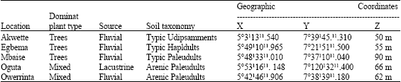 | |
| (Source: Onweremadu, 2006), X = Latitude, Y = Longitude, Z = Elevation | |
| Table 2: | Weighted means and coefficient of variation (CV) for particle size distribution of soils in the study site |
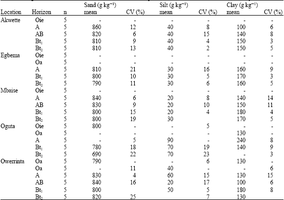 | |
Little variation in particle size distribution in the upper horizons suggests similarity of influencing factors in the pedogenesis of these soils and sand-sized fraction (CV = 22%) in Oguta indicate varying rates of eluviation and illuviation. There is outstanding development of argillic horizon (Bt) in all locations except at Akwette, confirming advanced illuviation and argillation in the floodplain soils.
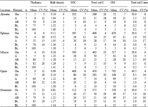
The average solum thickness of the mineral soils varied among locations and pedons (Table 6). The Oie horizons ranged in thickness from 3 to 9 cm and had lower bulk density values (0.09-0.81 Mg m-3) and SOC concentrations (300-408 g kg-1) (Table 3). Akwette and Mbaise soils lacked Oa horizons, Oguta soils had the thickest Oie-Oa horizons of 7-9 cm, respectively, but the bulk density values were correspondingly low (0.09-0.10 Mg M-3). Bulk density values decreased spatially and with depth, possibly due to changes in organic matter distribution as well as land use pattern. The Oa horizons were thin (3-7 cm) but there is greater likelihood that they mixed with the underlying A-horizons as a result of pedoturbation. Results of coefficient of variation in the organic horizons indicate little to moderate variation, suggesting that a number of factors such as soil type, vegetation type, management history, stand age and micro-climate may also be important in explaining spatial variability in soil carbon.
| Table 3: | Weighted means and coefficient of variation (CV) for thickness (cm), bulk density (M gm-3), soil organic carbon (SOC) (g kg-1), total soil C (g kg-1), organic matter (OM) (g kg-1) and total soil organic carbon/area (mg ha-1) of soils in the study site |
 | |
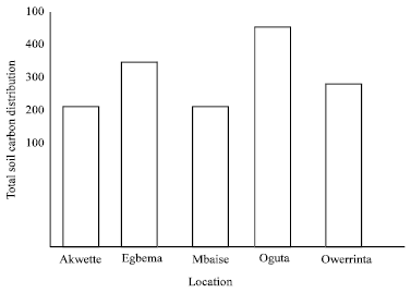 | |
| Fig. 1: | Proportion of total soil carbon stored in O-A horizons in the 5 study sites |
Total Soil Carbon Distribution
Total soil carbon including the organic horizons ranged from 0.1 mg C ha-1 (deepest mineral horizon in Akwette) to 40.5 mg C ha-1 in Oie horizon in Oguta (Table 3). Higher values of total soil carbon in Oguta soils is attributable to lacustrine origin of soils unlike other locations that under fluvial activities. It is true that organic horizons contain the largest proportion of the soil carbon (Fig. 1), but appreciable quantities are stored in mineral horizons. Torn et al. (1997) found 33-70% of soil organic carbon in the total soil carbon pool in sub-surface horizons, emphasizing the importance of subsoil horizons in contributing to total soil carbon.This particularly important in shrubby crops which have subsoil as rooting zone.
| Table 4: | Summary of one way analysis of variance comparing Total soil C (mg ha-1) within soils of the study locations |
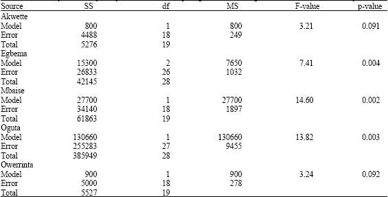 | |
| SS = Sum of squares; df = Degree of freedom; MS = Mean squares | |
There was no significant difference at 5% level of probability in total soil carbon in two locations, namely Akwette and Owerrinta despite physiographic differences (Table 4) in the other 3 floodplain, Egbema, Mbaise and Oguta. Total soil carbon stored varied significantly within them at p = 0.004 (Egbema), p = 0.002 (Mbaise) and p = 0.003 (Oguta). Environmental factors determine variation in organic matter contents in tropical soils (Feller, 1993) and these include rainfall, erosion, hydro-morphology and soil texture (Igwe, 2001). The CV results showed that total soil carbon varies greatly at top horizons similar to the findings of Kabrick et al. (1997) in Wisconsin.
CONCLUSIONS
The spatial variability data collected in this study are helpful in estimating soil carbon pools in floodplain soils of southeastern Nigeria. Three of the 5 locations have significantly different pools of total soil carbon, showing that data from a single pedon may not provide reliable data on soil carbon distribution in the area. An input of Geographic Information System (GIS) into similar studies can improve the status by producing customized maps in these floodplain soils. More intensive sampling at series level delineations will certainly yield more reliable data on the distribution and storage of soil carbon which can in turn be used in programming decision support systems in low-input agriculture characteristic of most developing countries. Increased database generation is becoming highly imperative with expansion of farming to floodplains due to heightened demographic pressure.
ACKNOWLEDGMENT
Grateful to the technical staff, Department of Soil Science, University of Nigeria, Nsukka Nigeria for assistance in field trips.
REFERENCES
- Bockheim, J.G., K.M. Hinkel, W.R. Eisner and X.Y. Dai, 2004. Carbon pools and accumulation in an age series of soils in drained Thaw-lake Basins, Arctic Alaska. Soil Sci. Soc. Am. J., 68: 697-704.
Direct Link - Brejda, J.J., M.J. Mausbach, J.J. Goebel, D.L. Allan, T.H. Dao, D.L. Karlen, T.B. Moornian and J.L. Smith, 2001. Estimating surface soil organic carbon content at a regional scals using the national resources inventory. Soil Sci. Soc. Am. J., 65: 842-849.
Direct Link - Davis, A.A., M.H. Stilt and J.E. Compton, 2004. Spatial distribution of soil carbon in Southern New England Hardwood forest Landscapes. Soil Sci. Soc. Am. J., 68: 895-903.
Direct Link - Eswaran, H., E. van den Berg and P. Reich, 1993. Organic carbon in soils of the world. Soil Sci. Soc. Am. J., 57: 192-194.
Direct Link - Feng, X., J.C. Peterson, S.A. Quideau, R.A. Virginia, R.C. Graham, L.J. Sonder and O.A. Chadwick, 1999. Distribution accumulation and fluxes of soil carbon in four monoculture lysimeters at San Dimas Eperimental Forest, California. Geochim. Acta, 63: 1319-1333.
Direct Link - Homann, P.S., P. Sollins, M. Ficorella, T. Thorson and J.S. Kern, 1998. Regwial soil organic carbon storage estimates for western Oregon by multiple approaches. Soil Sci. Soc. Am. J., 62: 789-796.
Direct Link - Igwe, C.A., 2001. Water-stable aggregates of Niger floodplain soils and their organic carbon, nitrogen and phosphorus distribution. Agron. Sci., 2: 52-61.
Direct Link - Johnson Maynard, J.L., P.J. Shouse, R.C. Grahana, P. Castiglione and S.A. Quideau, 2004. Microclimate and pedogenic implications in a 50-year-old Chaparral and pine biosequence. Soil Sci. Soc. Am. J., 68: 876-884.
Direct Link - Kern, J.S., 1994. Spatial patterns of soil organic carbon in the contiguous United States. Soil Sci. Soc. Am. J., 58: 439-455.
Direct Link - Marion, G.M. and W.C. Oechel, 1993. Mid-to late-Holocene carbon balance in artic Alaska and its implications for future global warning. Holocene, 3: 193-200.
Direct Link - Obi, M.E. and F.K. Salako, 1995. Rainfall parameters influencing erosivity in Southeastern Nigeria. CATENA., 24: 275-287.
CrossRefDirect Link - Pennock, D.J. and C. Kessel, 1997. Effect of agriculture and clear-cut forest harvest on landscape-level soil organic carbon storage in Saskatchewan. Can. J. Soil Sci., 77: 211-218.
Direct Link - Quideau, S.A., M.A. Anderson, R.C. Graham, O.A. Chadwick and S.E. Trumbore, 2000. Soil organic matter processes: Characterization by 13CNMR and 14C measurements. For. Ecol. Manage., 138: 9-27.
Direct Link - Quideau, S.A., O.A. Chadwick, S.E. Trumbore, J.L. Johnson-Maynard, R.C. Graham and M.A. Anderson, 2001. Vegetation control on soil organic matter dynamics. Org. Geochem., 32: 247-252.
CrossRefDirect Link - Tan, Z.X., R. Lal, N.E. Smech, F.G. Calhoun, R.M. Gehring and B. Parkinson, 2003. Identifying associations among soil and site variables using canonical correlation analysis. Soil Sci., 168: 376-382.
Direct Link - Torn, M.S., S.E. Trumbore, O.A. Chadwick, P.M. Vitousek and D.M. Hendricks, 1997. Mineral control of soil organic carbon storage and turnover. Nature, 389: 170-173.
Direct Link - Ulery, A.L., R.C. Graham, O.A. Chadwick and H.B. Wood, 1995. Decade-scale change of soil carbon, nitrogen and exchangeable cations under Ob chaparral and pine. Geoderma, 65: 121-134.
Direct Link