
Ruminta
Departemant of Agronomy, Faculty of Agriculture, Padjadjaran University, Indonesia
LiveDNA: 62.12145
Handoko
Departement of Geophysica and Meteorology, Faculty of Mathematica and Science, Bogor Agricultural University, Indonesia
Asian Journal of Crop Science
Year: 2016 | Volume: 8 | Issue: 2 | Page No.: 31-42


ABSTRACT
Background and Objective: There is strong evidence that climate change causes the annual increase of average global temperature, changes in rainfall patterns, the increase of sea levels and the rise of frequency and intensity of extreme weather. Climate change influence agriculture such as the way crops grow, develop and yield. Agriculture is vital to the progress of Indonesia, because more than 60% of population depend on agriculture for their livelihood. The contribution of the agricultural sector to the total economy, however is challenged by its vulnerability to climate change. Study on vulnerability in agricultural sector due to climate change has been implemented in South Sumatra Indonesia. The objectives of this study are to assess the evidence of climate change, the level of vulnerability and identify areas that high level of vulnerability in agricultural sector in that region. Materials and Methods: Materials of this study is data of climate, agroclimate and staple food crops (Paddy, corn, soybean) and socio-economic that obtained by survey, interviews, public hearings and data collection from some relevant sources. Methods of this study is descriptive explanatory that using the concept of vulnerability assessment. Vulnerability is a function of exposure, sensitivity and adaptive capacity. Results: The results of this study indicate that to some extent in South Sumatra has experienced climate change shown by the changing patterns of air tempertature, rainfall, hythergraph and Oldeman classification. The high exposure showed in South Sumatra such as Banyuasin and Ogan Komering Ilir. Most districts of South Sumatera is dominated by very high sensitivity. Some areas of South Sumatra such as Lubuk Linggau and Pagar Alam have very high adaptive capacity. South Sumatra experience high level of vulnerability to climate change. Conclusion: The areas that shown experience high level of vulnerability of decreasing production of wetland paddy, upland paddy, corn and soybean respectively are East Ogan Komering Ulu, Muara Enim, Musi Banyuasin and East Ogan Komering Ulu. Generally, South Sumatra Indonesia has high vulnerability and risk in agricultural sector. High vulnerability and risk in agricultural sector will disrupt food security in Indonesia.
PDF Abstract XML References Citation
Received: February 18, 2016;
Accepted: March 03, 2016;
Published: March 15, 2016
How to cite this article
Ruminta and Handoko, 2016. Vurnerability Assessment of Climate Change on Agriculture Sector in the South Sumatra Province, Indonesia. Asian Journal of Crop Science, 8: 31-42.
DOI: 10.3923/ajcs.2016.31.42
URL: https://scialert.net/abstract/?doi=ajcs.2016.31.42
DOI: 10.3923/ajcs.2016.31.42
URL: https://scialert.net/abstract/?doi=ajcs.2016.31.42
INTRODUCTION
There is strong evidence that global warming over the last century causes the annual increase of average global temperature, changes in rainfall patterns, the increase of sea levels and the rise of frequency and intensity of extreme weather. The study of the Intergovernmental Panel on Climate Change (IPCC)1,2 showed that climate change has occurred with some evidences; the increase of the average global temperatures (an increase of 0.76°C from 1899-2005) the increase of the global average sea level (an increase of 1.8 mm year–1 from 1961-2003), the increase of the uncertainty and intensity of rainfall, flooding, drought and erosion become more frequent and the extreme weather phenomena, such as El Nino, La Nina, cyclone, tornado and hailstone become more frequent. Furthermore, global climate change is very sensitive to various aspects in human living systems3,4, that is (1) Water management and resources, (2) Agriculture and food availability, (3) Terrestrial and freshwater ecosystems, (4) Coastal and ocean, (5) Human health and (6) Residencies, energy, industry and financial services.
Climate change threats crop production systems and therefore also threats the livelihood and food availability for billions of people who depend on agriculture. Evidence suggests that poor populations more suffer than rich populations, such as industrialized countries1,5, because of the effects of climate change. Not only the relatively poor countries will experience more severe impacts but the impact also threats those who lacking resources to prepare and overcome environmental risks. Agriculture is the most vulnerable sector to climate change because of its dependencies on climate and weather and the people who involved in the agricultural sector tend to be poorer than their counterparts in the city6,7.
The influence of global climate change, especially on the agricultural sector has been felt and become reality. This climate change is indicated by the floods, drought and the shift of rainy season. In recent years, the shift of rainy season causes the shift of planting and harvesting seasons of food commodities (rice, pulses and vegetables). In addition, floods and drought cause planting and crop failures and even puso8.
In Indonesia, change of rainfall patterns is probably the biggest threat, because so many farmers depend directly on rainfall for their agricultural activities and livelihoods. Every changes of rainfall pose a great risk. Rainfed agriculture is very susceptible to climate change, if the farming activities remain unchanged. Meanwhile, the quality of fresh water will increasingly affect farming systems in coastal areas due to sea water intrusion and unsustainable irrigation activities. High salinity due to increasing sea level becomes a threat to food crop production in coastal areas because many varieties are not resistant to high salinity9. Furthermore, high temperature will affect the agricultural system. Plants are very sensitive to high temperatures during critical stages, such as flowering and seed development. Combined with drought, high temperatures can cause disaster for agricultural lands. Changes in temperature and humidity can also lead to the development and sprawl of pests and plant diseases. Floods and droughts also affect agricultural productions. Floods and prolonged droughts caused by bad water management and low capacity, make significant decrease in productions10.
Climate change in a region is also indicated by the existence of seasonal climate variability. Seasonal climate variability in Indonesia is marked by the occurrence of droughts, unpredictable rains and relatively short period of rainfall. This variability results in harvests and crops failure of food crops such as rice, pulses and vegetables. In other words, seasonal climate variability is one of the main causes of decline in agricultural productions, especially the productions of food crops, plantations, forestry and even livestock6.
Based on fact, climate experts state that un-uniform climate variation related with extreme climate event of El Ni o Southern Oscillation (ENSO). For example, Boer and Meinke11 suggest that, in particular seasons Southern Oscillation has a strong influence on climatic factors, such as rain, change of cloud coverage which affects radiation, temperature, evaporation and humidity, which is affect plant growth in the monsoon regions, such as Java, Eastern Indonesia and Southern Sumatra. Extreme climate events, such as El Ni o and La Nina, in Indonesia affect the development of food crop production. The strong influence of ENSO can be proved by examining the events of drought in various regions in Indonesia, which is coincided with the El Ni o events12,13.
Extreme climate event (El Ni o) illustrates that food production in agricultural sector are highly susceptible to climate changes and anomalies. If there is a decrease in productivity due to crop failure and puso then the probability of food insecurity would be high. In the agricultural sector, climate change and extreme climate cause the vulnerability of food productions. Effect of extreme climate to the decline of national agricultural production is not always visible because of several things11,14,15, (1) Statistical data based on calendar year when El Nino is not occurred, (2) Not all regions in Indonesia has always been influenced by El Nino, (3) Lack of water due to El Nino may alter the original decision of farmers, for example planting soy or other plants instead of paddy and (4) Lack of water will reduce the planted area on irrigated land but the output per unit area will increase due to the increase of radiation intensity9.
The extent of climate change to affect agricultural systems depends on various factors, including the type of crops, operation scales, farming orientations toward commercial or subsistence purposes, the quality of the natural resource bases and the influence of human and farm manager (for example, education, risk tolerance, age, etc.)16,17. Vulnerability is also mediated by institutional factors, including the rules and policies of land ownership, markets availability, capital, insurance, financial support and technological development and distribution. Diversity of climate patterns, farming systems, social conditions, economy, politic and environment make vulnerability unevenly distribute across regions and social groups in Indonesia. These diversities become a challenge in developing a methodology for vulnerability assessment that accurately captures the spatial dimension of vulnerability in Indonesia. Therefore it is necessary to identify the areas in agriculture, production systems and populations which are the most vulnerable to climate change9.
South Sumatra province is located in the South of the equator from 10-40° South latitude and longitude from 102-108° East longitude. South Sumatra cover an area of 87,017 km2 (8,701,742 ha) or 19.6% of the total area of Sumatra island (443,065.8 km2) or 1.68% of the total land area of Indonesia. The climate in this region is tropic and wet. There are only two seasons in this province, the rainy and dry season. Air temperature varies between 24.7 and 32.9°C with humidity levels ranging from 82-88%. Rainy season usually occurs from October until April. The variation of rainfall ranges from 2100-3264 mm. The highest rainfall usually occurs in December, while the dry season usually starts from June until September18,19.
South Sumatra, which has two seasons the rainy and dry seasons is closely related to the location of this island which is near the equator and between two continents, Asia and Australia and also between two oceans, Indian and Pacific oceans. The beginning and the end of rainy season in South Sumatera are highly uncertain. Sometimes rainy season occurs from November until April but the starting and ending time varies depend on its location and natural phenomena. The dry season occurs from April until October. When coincided with the El Niño phenomena, droughts usually occur in South Sumatra which is marked by the rainy season starting in mid-November and even in early December20.
The productivity of rainfed in South Sumatra is correlated with rainfall patterns because the source of irrigation water comes from rains. Average annual rainfall varies according to season and region. About 80% of annual rainfall occurs between September and February. The period between April and August is really dry and only produce less than 10% of annual rainfall21. Agricultural land in South Sumatra consists of dry land in the form of fields and farm. Farm consists of technical irrigated farm, i.e., farm that always get water throughout the year, rainfed is farm which irrigation depends entirely on rainfall, tidal swamp land is wetland that irrigation water depend on tidal rivers and wetlands valley. Currently, perennial wetland area of 752,150 ha, which consist of 399,521 ha or 55% of irrigated land, 113,655 ha or 15% is the tidal wetland, lowland rice and rainfed and the remaining 238,974 ha or 30% is wetland that has not been planted18,19.
Climate change vulnerability on agriculture sector in South Sumatera is affected by exposure, sensitivity and adaptive capacity indicators. Vulnerability is the degree of ability of an individual or groups of people or communities to anticipate and cope with maintaining the continuity of life and save themselves from the impact caused by the nature hazard. Vulnerability is always changing along with the changes of socio-economic conditions and surrounding environments22,23.
The objective of this study is providing framework to approach the challenge of climate change by forming knowledge basis in climate effect and basic concept about how to build adaptive capacity and long live immunity, giving critical synthesis from the proof and future scenario of climate change by analyzing and testing the vulnerability of farming sector in South Sumatera on variability and climate change and developing vulnerability level to identify farming regions, which are the most susceptible in those regions. In addition, the study offers an assessment of policy options and investment for development practitioners and policy makers, outlining strategies to overcome the threat of climate change and provide knowledge of the available opportunities for poor farmers to face climate change and arrange conceptual framework to build climate change immunity in the agricultural sector in South Sumatra9.
MATERIALS AND METHODS
Types and sources of data that are analyzed in the vulnerability assessment of climate change in agricultural sector are of secondary and primary data. Secondary data came from documents of the Department of Agriculture district, Department of Agriculture of South Sumatra province, Central Bureau of Statistics and other relevant bodies. Primary data are collected through field observation, interviews and questioners to the key informants consisting of the party-food crops such as rice farmers and the heads of farmer groups, agricultural extension or the competent authorities to handle the affairs of climate and agricultural production at district and province level of South Sumatra.
Study methods using survey, interviews, public hearings and the collection of data from some relevant sources. Methods of data analysis in this study are inductive data analysis that is think-flow to draw conclusion from data that are specific to the general conclusion drawn. Inductive method that is used to draw conclusion on the phenomena and elements of climate change and climate variability is illustrated by the data already collected through observation, interviews and questioners and then mapped by GIS.
Three dimensions of vulnerability: The Intergovernmental Panel on Climate Change1 defines vulnerability as a function of the magnitude, character and the rate of climate variation of a system affected by exposure, sensitivity and adaptive capacity3,24-26. More succinctly, the vulnerability is defined as having three components: exposure, sensitivity and adaptive capacity (Fig. 1).
Exposure (E): Exposure is used to describe the biophysical impacts of climate change on agro-ecological systems27,28. Exposure to the agricultural sector includes the spatial and temporal dimensions of the impact of climate variability and change, such as increased temperature, drought and torrential rain, the magnitude and duration of extreme weather events and also sea level rise.
Sensitivity (S): Sensitivity is defined as the degree of system to be influenced by the climate change, whether adverse or profitable and refers to the ability of agro-ecological systems to withstand the impact without any effort to adapt. Sensitivity is a complex concept because the system’s response can be influenced by the intrinsic characteristics and the degree of external interference, such as the type of agricultural land, farmer’s income, labour composition, topography and others. In the vulnerability assessment of agricultural sector, the type of agricultural land, farmer’s income and the composition of the workforce is used as the sensitivity indicators.
Adaptive Capacity (AC): The third dimension of vulnerability is the adaptive capacity, which is defined as the ability of institutions and individuals to avoid potential damage, to take advantage of opportunities or to overcome due to the change. It is the most difficult aspects of vulnerability due to many socio-economic variables determine the adaptive capacity. Indicators, such as poverty, access to credit, education level, population and income can be used to measure the adaptive capacity.
Vulnerability (V): Vulnerability assessment of climate change on agriculture in South Sumatra is a meso level study which examines the phenomena and the vulnerability of the agricultural sector to climate change. The study is focused on analyzing the impact of climate change and climate variability, such as temperature and rainfall patterns change monthly, as well as increased frequency and intensity of extreme events, such as La Ni a and El Ni o. In addition, sea level rise will cause a reduction in agricultural land area, especially around the coast. Vulnerability is the ability of an individu, society or community in anticipating, preventing and maintaining viability from impacts caused by natural hazards.
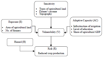 | |
| Fig. 1: | Flowchart of the analysis of hazard potentials, vulnerability and risk of climate change on agricultural sector8 |
Climate change is affecting the vulnerability of agriculture sector in South Sumatera, making this climate vulnerability assessment to climate change very important8,29,30. Flowchart of vulnerability assessment of climate change on agriculture sector is presented in Fig. 1.
Vulnerability assessment uses an assumption that vulnerability is directly proportional with exposure and sensitivy, while inversely proportional with adaptive capacity which can be expressed as8,31:
![]()
| V | = | Vulnerability |
| E | = | Exposure |
| S | = | Sensitivity |
| AC | = | Adaptive capacity |
The indicators for the three vulnerability components are: (1) Agricultural land area and number of farmers as exposure’s indicators, (2) Agricultural land types (non-irrigated), topography (elevation) and farmer’s income as sensitivity’s indicators and (3) Irrigation infrastructures, level of education and agriculture sector’s income contribution to Produk Domestik Regional Bruto (PDRB) as adaptive capacity’s indicators. Every indicator is weighted using the "pairwise comparison" which then mapped spatially by using the Geographic Information System (GIS). From the analysis result, we can see the distribution of spatial vulnerability for every sub-district in South Sumatera8.
RESULTS
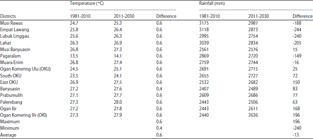
Indicators climate change: Based on the analysis of rainfall and air temperature, South Sumatera region has experienced climate change which the air temperature generally increases in the ranged from 0.4-0.6°C. Meanwhile, rainfall has decreased for the Northern part of South Sumatera (0-197 mm) and has increased in the Southern and South Eastern parts (0-227 mm) as shown in Table 1.
The changes in rainfall and air temperature affect changes of monthly air temperature pattern and hythergraph in South Sumatera region as shown in Fig. 2. On the hythergraph, it is clearly seen a shift pattern of air temperature to rise while the pattern of rainfall does not change significantly.
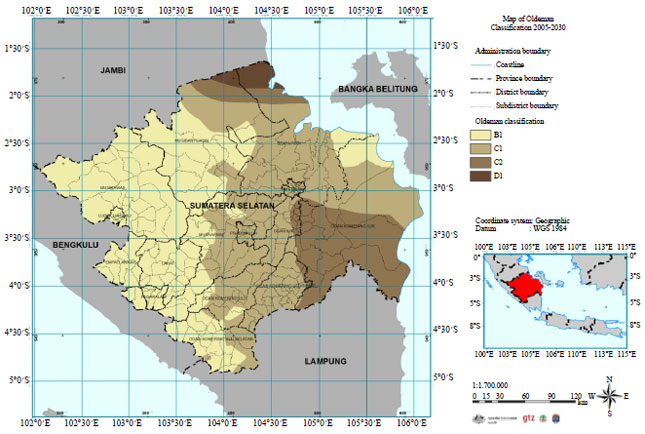
Based on the analysis of rainfall distribution using Oldeman climate classification, climate types of South Sumatera region has changed as shown in Fig. 3 and 4.
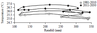 | |
| Fig. 2: | Changes in hythergraph in South Sumatera for the period 1981-2010 and 2011-2030 period |
| Table 1: | Rainfall and air temperature changes in South Sumatera for 1981-2010 and 2011-2030 period |
 | |
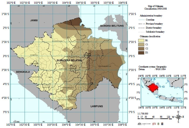 | |
| Fig. 3: | Oldeman classification in South Sumatera for the period of 1981-2010 |
 | |
| Fig. 4: | Oldeman classification in South Sumatera for the period of 2011-2030 |
There are five areas in in South Sumatera experiencing changes in Oldeman climate types that are Musi Rawas (from B1-B1 and D1), Musi Banyuasin (B1-B1 and D1), East OKU (from C2 -C1), Ogan Ilir (from C2-C1) and OKI (C1 and C2-C1, C2 and B1).
Exposure on agriculture sector: The exposure to climate change on agriculture sector in South Sumatera uses two indicators, agriculture land area and number of farmers. The results of exposure analysis are shown in Fig. 5. The exposure level of climate change on agriculture sector in South Sumatera varies from very low such as in Empat Lawang, Lahat, Kota Lubuk Linggau, Pagar Alam, OKU, South OKU, Prabumulih and Palembang, very high in Banyuasin dan OKI. Muara Enim and East OKU have low exposure level. Meanwhile, Musi Banyuasin and East OKU have moderate exposure level.
Sensitivity on agriculture sector: The result of sensitivity analysis is shown in Fig. 6. Based on the result of sensitivity analysis in Fig. 6, climate change sensitivity on agriculture sector in South Sumatera is dominated by very high sensitivity, except for Pagar Alam with very low sensitivity, Lubuk Linggau, Lahat, OKU and South OKU with moderate sensitivity and Empat Lawang and Musi Rawas with high sensitivity.
Adaptive capacity on agriculture sector: The result of this analysis is shown in Fig. 7. The result of adaptive capacity analysis in Fig. 7 shows that the climate change adaptive capacity of agriculture sector in South Sumatera is generally very low, low and moderate, except in Lubuk Linggau and Pagar Alam that have very high adaptive capacity.
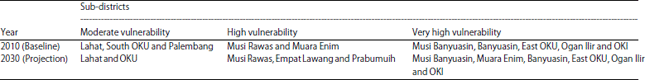
Vulnerability on agriculture sector: The result of vulnerability analysis is presented in Fig. 8 and 9. Figure 8 shows that the vulnerability levels are varied and dominated by very high level in Musi Banyuasin, East OKU, Banyuasin, Ogan Ilir, OKI, Musi Rawas and Muara Enim. Empat Lawang, Lubuk Linggau, OKU and Prabumulih have very low vulnerability levels, while Lahat, South OKU and Palembang have moderate level of vulnerability. The projection of vulnerability in Fig. 9 shows some areas are still dominated by high and very high vulnerability levels such as in Musi Banyuasin, East OKU, Banyuasin, Ogan Ilir, OKI, Musi Rawas, Muara Enim, Empat Lawang and Prabumulih. There are only two sub-districts, Lahat and OKU, which have moderate vulnerability level.
The summary of vulnerability changes on agriculture sector in South Sumatera between baseline 2010 and projection 2030 based on medium emission scenario SRAIB are shown in Table 2.
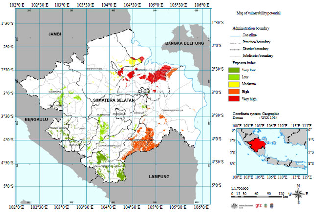 | |
| Fig. 5: | Map of 2010 exposure |
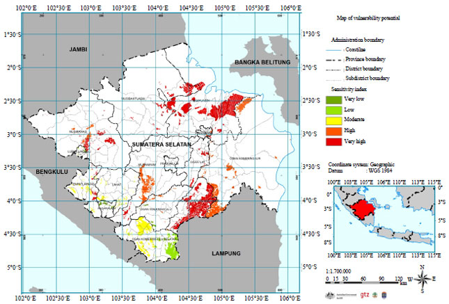 | |
| Fig. 6: | Map of 2010 sensitivity |
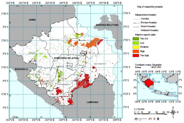 | |
| Fig. 7: | Map of 2010 adaptive capacity |
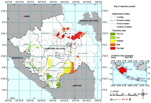 | |
| Fig. 8: | Map of 2010 vulnerability |
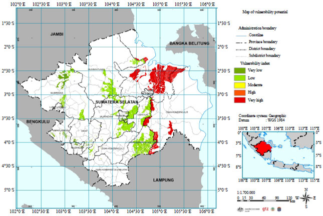 | |
| Fig. 9: | Map of 2030 vulnerability |
| Table 2: | Distribution of climate change vulnerability on agriculture sector in South Sumatera (2030) |
 | |
DISCUSSION
South Sumatera region has experienced climate change showed by changes of air temperature, rainfall, hythergraph and climate classification. The air temperature generally increases in the average 0.6°C and rainfall decreases in the average 13 mm. The change of hythergraph and climate classification show that the South Sumatera region becomes warmer. The level of climate change in Indonesia is different from the global climate change1 and other places such as Indian, Serbia and Ethiopia25,26,31. This certainly has significant impact on plant water availability, growing season, start of planting and the preference of crop commodities cultivated in South Sumatera. South Sumatera has a tropical climate with two seasons, wet and dry seasons. The duration of wet season is relatively short compared to the dry season and the onset of wet season is often uncertain, affecting agriculture sector especially the planting time and growing period. That evidences of climate change greatly affects the vulnerability on the agricultural sector in South Sumatra. High vulnerability in agricultural sector will risk to decrease the production of food crops that has implications for food supply, which is a component of food security in Indonesia and other place32.
Generally, urban regions of South Sumatra do not have exposure potential because the agricultural lands are small and low number of farmers. In South Sumatra such as Banyuasin and OKI have very high level of exposure potential because both have large area of agricultural lands and high number of farmers. Exposure was limited as components of the agricultural sector affected by climate change that is the land area and the number of farmers. The greater the land area and number of farmers in South Sumatra, the value of exposure will increase. High levels of exposure will increase high levels of vulnerability in agriculture sector22,27,31.
Sensitivity describes the response of the agricultural sector to climate change, stating the magnitude changes in the land area and number of farmers due to climate change. In districts of South Sumatra with many non-irrigated agriculture fields, flat lowland areas and low farmer’s income, the sensitivity potential is very high. Generally, South Sumatera has a very high sensitivity potential due to its large area of non-irrigated agricultural fields, flat lowland areas and also low farmer’s income. High levels of sensitivity will increase high levels of vulnerability in agriculture sector27.
Adaptive capacity describes the ability of the agricultural sector for adaptation to climate change. In this case, adaptive capacity depend on the level of education, income, population and infrastructure (irrigation system). In sub-districts which have low irrigation infrastructures, farmer’s education level and agriculture sector’s PDRB, the adaptive capacity potential is very low. Generally, South Sumatera has low and very low adaptive capacity due to its relatively low irrigation infrastructures, farmer’s education level and PDRB’s agriculture sector. High levels of adaptive capacity will decrease high levels of vulnerability in agriculture sector32.
The vulnerability amount of climate change in South Sumatra strongly depends on the weight of three components of vulnerability that is the exposure, sensitivity and adaptive capacity. The greater the exposure and sensitivity will increase the vulnerability of climate change. However, if adaptive capacity is very high then the vulnerability of climate change will be reduced. The amount of the weight of exposure, sensitivity and climate change adaptation capacity in South Sumatra can be studied from each of these indicators. Vulnerability to climate change of farmers in South Sumatra was highly related to marginal total farm size and poor social network. The level of vulnerability of different social groups to climate change is determined by both socio-economic and environmental factors31,33.
In 2010 (baseline), South Sumatera will have a high level of vulnerability due to high level of exposure and sensitivity and low adaptive capacity. Musi Banyuasin, East OKU, Banyuasin, Ogan Ilir and OKI have very high level of vulnerability because of high level of exposure and sensitivity, while the adaptive capacity is very low. The five sub-districts have large agricultural areas but low irrigation and irrigation infrastructures. Generally, urban areas have low exposure and sensitivity and high adaptive capacity, making urban areas have very low level of vulnerability to climate change25.
Projection of vulnerability for 2030, most areas of South Sumatera do not experience vulnerability change, such as in Musi Rawas, Lahat, Musi Banyuasin, OKU Timur, Banyuasin, Ogan Ilir and OKI. However, other parts experience change such as Empat Lawang (low-moderate), Lubuk Linggau (very low-low), Muara Enim (high-very high), OKU (low-medium), OKU Selatan (moderate-low), Prabumulih (low-high) and Palembang (moderate-low). Changes in 2030 are mainly related with the dynamical change in non-irrigated regions and irrigation infrastructures. High or very high level of vulnerability indicates that the climate change impact on crop production in South Sumatera would be very high. Therefore, adaptation strategy is needed to be improved, so that the vulnerability level will not suppress the agricultural production, food availability and food sufficiency in South Sumatera.
In South Sumatera, areas that experience the risk of decreasing production of staple food crops such as wetland paddy, upland paddy, corn and soybean respectively are East OKU, Muara Enim, Musi Banyuasin and East OKU. Generally, South Sumatera experiences great declining of food crops productivity rate with an average of 1.37% (wetland paddy), 0.98% (upland paddy), 0.91% (corn) and 0.86% (soybean) year–1.
The agriculture sector is vulnerable to the impacts of climate change, indicated by hazards such as decreasing productivity, harvested area and production of paddy, corn and soybean due to air temperature increase and rainfall change33. Future consequences include declining surplus of food crops. Generally, the region that has high vulnerability trigged risk in agricultural sector34. High vulnerability and risk in agricultural sector will disrupt food security27,32,33.
CONCLUSION
South Sumatra province has experienced climate change shown by the changing patterns of air tempertature and rainfall. The air temperature increases between 0.4-0.6°C and rainfall has been more fluctuative since 1981. This change is also indicated by the change of hythergraph and Oldeman classification in South Sumatra. The high exposure showed in South Sumatra such as Banyuasin and Ogan Komering Ilir. Most districts of South Sumatera is dominated by very high sensitivity. Some areas of South Sumatra such as Lubuk Linggau and Pagar Alam have very high adaptive capacity. In South Sumatra, areas that shown experience high level of vulnerability are Musi Rawas, Musi Banyuasin, Muara Enim, East Ogan Komering Ulu, Banyuasin, Ogan Ilir and Ogan Komering Ilir because of high level of exposure and sensitivity, while the adaptive capacity is very low. In South Sumatera, areas that experience the risk of decreasing production of staple food crops such as wetland paddy, upland paddy, corn and soybean respectively are East OKU, Muara Enim, Musi Banyuasin and East OKU. Generally, South Sumatra Indonesia has high vulnerability and risk in agricultural sector. High vulnerability and risk in agricultural sector will disrupt food security in Indonesia.
ACKNOWLEDGMENTS
The authors are very indebted to the STRANAS 2014 Research Grant and LPPM of Padjadjaran University Indonesia for providing all the facilities to achieve this study and funding this publication.
REFERENCES
- Bar, R., E. Rouholahnejad, K. Rahman, K.C. Abbaspour and A. Lehmann, 2015. Climate change and agricultural water resources: A vulnerability assessment of the Black Sea catchment. Environ. Sci. Policy, 46: 57-69.
CrossRefDirect Link - Manton, M.J., P.M. Della-Marta, M.R. Haylock, K.J. Hennessy and N. Nicholls et al., 2001. Trends in extreme daily rainfall and temperature in Southeast Asia and the South Pacific: 1961-1998. Int. J. Climatol., 21: 269-284.
Direct Link - Metternicht, G., A. Sabelli and J. Spensley, 2014. Climate change vulnerability, impact and adaptation assessment: Lessons from Latin America. Int. J. Climate Change Strat. Manage., 6: 442-476.
CrossRefDirect Link - Yasin, I., M. Ma'shum, Y. Abawi and L. Hadiawaty, 2002. Flowchat use to determine early summer rain and develop strategy of land rice cultivation in rainwater in lombok Island. Proceedings of the Farmer Income Imrpovment Through Agricultural Resources Utilization and Application of Appropriate Technolgy, Nopember 20-21, 2002, Indonesia.
- Irawan, B., 2002. Stabilization of upland agriculture under El nino-induced climatic risk: Impact assessment and mitigation measures in Indonesia. Working Paper No. 62, Center for Research and Development of Coarse Grain, Pulses, Roots and Tuber Crops in the Humid Tropics of Asia and the Pacific, pp: 78.
- Handoko, I., 2008. Relationship between crop developmental phases and air temperature and its effect on yield of the wheat crop (Triticum aestivum L.) grown in Java Island, Indonesia. J. Biotropia, 14: 51-61.
Direct Link - Wolf, S., 2011. Vulnerability and risk: Comparing assessment approaches. Nat. Hazard., 61: 1099-1113.
CrossRefDirect Link - Young, B.E., N.S. Dubois and E.L. Rowland, 2015. Using the climate change vulnerability index to inform adaptation planning: Lessons, innovations and next steps. Wild Life Soc. Bull., 39: 174-181.
CrossRefDirect Link