
Abdulla Al-Shorman
Department of Anthropology, Faculty of Archaeology and Anthropology, Yarmouk University, Irbid-Jordan
Trends in Applied Sciences Research
Year: 2006 | Volume: 1 | Issue: 1 | Page No.: 61-72


ABSTRACT
This study entails the current and future states of archaeological science in Jordan. It discusses the limitations and opportunities in conducting a multidisciplinary archaeological research in Jordan. It discusses the possibility of applying the advanced spatial statistics on the distribution of archaeological sites in Jordan and shows the possibility of incorporating Geographic Information System (GIS) in archaeological site modeling.
PDF Abstract XML
How to cite this article
Abdulla Al-Shorman, 2006. The Current State of Archaeological Science in Jordan. Trends in Applied Sciences Research, 1: 61-72.
URL: https://scialert.net/abstract/?doi=tasr.2006.61.72
URL: https://scialert.net/abstract/?doi=tasr.2006.61.72
INTRODUCTION
Jordan as a natural museum has been opened to archaeologists and early explorers since the early 19th century. The surveys of Burckhardt (1822), Jaussen and Savignac (1909, 1914), Kraeling (1938), Glueck (1934, 1935, 1939 and 1951) and Mittman (1970) have yielded rich archaeological data and consequently became preliminary for further surveys and explorations within the country. The above work was descriptive and lacked any scientific analysis due to the underdeveloped discipline of archaeology then, which consequently necessitated further archaeological excavations and studies. Most of the recent archaeological studies in Jordan are actually descriptive not better in any way than the earliest archaeological interpretations of sites and objects. Since then huge amounts of archaeological data have been accumulated but unfortunately without proper and scientific explanations even those that date after the establishment of the multidisciplinary archaeology in the 1960’s by Binford and his colleagues.
Not only the scarcity of skilful archaeologists who can apply the recent physical and chemical methods is the dilemma of archaeology in Jordan, but also the total concentration on sites that are dated to the classical period ignoring other time periods that would add much to the history of the country. One of these time periods is the Iron Age that is strongly connected to the old testament. The other problem is the ignorance of many contributing subfields in archaeology like landscape archaeology, which if properly performed can trace the past human activities on the landscape and the type of these activities, it also can shed light on the changes of subsistence strategies over time (Ashmore and Knapp, 1999). Another major problem is the availability of equipments at the academic institutions and governmental departments that care for archaeology. The equipments include specialized geophysical and remote sensing units for the purpose of scientific and systematic surveys; equipments for absolute dating either of organic and inorganic materials; equipments for carrying out isotopic analysis and advanced archaeological programs that would handle the large quantities of archaeological data like Geographic Information System.
Most of these equipments are very expensive, where the local academic and governmental institutions can not offer. Although there are a wide range of institutions that can fund archaeological researches where equipments are included, handful archaeologists in the country obtained huge grants where some where devoted to equipments. These grants include the establishment of a heritage center at Yarmouk University that was funded by TEMPUS (Al-Sa’ad, 2003: personal communication), the Arkansas-Yarmouk University joint project on the archaeological sites of Sa’ad, Yasieleh and Ya’amun (El-Najjar, 1994: personal communication).
The Concept of Archaeological Science
Archaeology tries to reconstruct and explain the consequences of development of human culture through the study of the material remains. To reconstruct the human cultural development an archaeologist needs to establish a proper chronology and know the natural environment, subsistence strategies and the physical and chemical characteristics of material culture. The collected data will then allow inferences about the economic, political, social and ideological systems. In order to achieve this aim, archaeologists should extract the maximum amount of information in the above mentioned categories. The most trusted way is to use the material culture that was left by ancient societies. Therefore archaeologists should adopt a wide-ranging multidisciplinary approach. Consequently the natural sciences must inevitably play an extremely important role in archaeology since they can assist in the location of sites, in the provision of an absolute world-wide chronology and in the description of the bio-cultural system.
In its endeavor to study material evidence, archaeology has strongly interacted with almost all scientific disciplines. Among these, chemistry has certainly played an important role. Chemistry has developed methods to date archaeological material and has also allowed us to infer trade routes by studying ancient artifacts and to shed light on the technology used to make them. The diet and customs of ancient peoples have also been discovered by applying chemical methods. Chemistry intervenes in the understanding of the mechanisms that cause archaeological material to degrade in order to set up procedures aimed at stabilizing decay and preventing further deterioration. It also tries to find the best way to restore ancient artifacts.
There are number of resources available to researchers involved in studies dealing with chemistry and archaeology. ‘Archaeometry’ and the ‘Journal of Archaeological Sciences’ are two specific journals devoted to the interactions between sciences and archaeology. The book by Brothwell and Pollard (2001) is a landmark in the field of archaeological sciences. The most recent book from Pollard and Heron (1996) concentrates on a series of case studies in archaeological science. The books from Lambert (1997) and Henderson (2000) are based on the study of a series of archaeological materials. Techniques of analytical chemistry applicable to archaeology have been discussed in the book edited by Ciliberto and Spoto (2000). All of these books are available at the library of Yarmouk University as well as other specialized books in the same field. Analytical chemistry plays an important role in the study of archaeological materials and has a variety of goals:
| 1- | To study the technology used in producing artifacts. |
| 2- | To reconstruct the distribution of artifacts from the production areas. |
| 3- | To understand the use to which they were put in the past. |
| 4- | To understand, at the deepest possible level, all the altering processes that intervene in the life cycle of the archaeological material. |
There are also a number of essential and necessary physical methods in archaeology. These methods include absolute dating: radiocarbon dating, thermoluminescence, potassium-Argon, electron spin resonance, Paleomagnetism (Aitken, 1990; Tylor and Aitken, 1997), geophysics: ground penetrating radar, electrical resistivity, magnometry (the book I have), elemental and isotopic analysis of organic and inorganic material using X-ray fluorescence and the mass spectroscopy (Lambert, 1997). These resources are also available at the main library of Yarmouk University.
The Current State of Archaeological Science
The last few years have witnessed a considerable shift toward using modern techniques and methods in archaeological material analysis. Al-Shorman (2004) used the Inductive Coupled plasma techniques to estimate the amounts of phosphorus in soil, which revealed changes in activity patterns during the transitional period of Late Bronze/Iron Ages. There are numerous bioarchaeological studies from Jordan that utilized the modern techniques like biomechanics (Asad, 2000), stable isotopes analysis (Al-Shorman, 2002a), trace element analysis (Al-Shorman, 2004; Shdouh, 2004), electron scanning microscopy (Rousan, 2005) and archaeological provenience and analysis (Abu Jaber and Al-Sa’ad, 2000; Khalil, 2001).
Natural sciences and particularly chemistry have contributed to the understanding of the chemical composition of various artifacts where provenance and method of manufacture can be inferred; examples from the Faculty of Archaeology and Anthropology were many and include the studies by Al-Sa’ad (1994a, b; 1996a, b). Each extinct culture had a distinctive material culture and thus allowing the comparison among cultures using chemical methods. In addition to the direct employment of natural sciences in archaeology of Jordan, experimental archaeology has found its way as a method of understanding the past (Al-Sa’ad, 1997). Experimental archaeology is currently and broadly used in the conservation of material culture. For example, the Faculty of Archaeology and Anthropology at Yarmouk University has become one of the leading academic institutions in devising new experiments on ancient textile, paper and stone (Al-Sa'ad, 2005: personal communication).
The extensive integration of natural sciences necessitates the use of high-speed computers to better assess archaeological data quantitatively and mathematically. Examples are population demography, cluster analysis of artifacts and spatial analysis of data using the modern techniques of Geographic Information Systems (GIS). Spatial analysis and GIS is currently used in cultural resource management in a broader context in Jordan (Al-Shorman, 2004; Magablih and Al-Shorman, 2004).
The multidisciplinary approach (or processual) in archaeology places a considerable burden on the individual archaeologists since it is essential that he understands something of the general principles of the scientific and mathematical techniques employed. Otherwise he will find it difficult either to ask the appropriate questions or to appreciate the potentialities and limitations of the techniques. Unfortunately, the number of archaeologists in Jordan who are approaching the study of the material culture multidisciplinary is few, which in turn affected the quality of their researches and the difficulty in making their collected data available to other local and regional archaeologists (Al-Saa’d, 1997).
The processual approach in archaeology that was first adopted by Binford and his colleagues in the late 1960's has moved the archaeological interpretations many steps forward until it became a science (Renfrew and Bahn, 1991) The shift from descriptive archaeology to the multidisciplinary archaeology has accumulated large amounts of data that are regionally and globally comparative. In the Middle East, particularly in the Levant, recent archaeological excavations that utilized modern archaeological and scientific techniques have enriched the archaeological picture and at the same time allowed researchers and students to inquire archaeological data from the adjacent regions. For example, the results of oxygen isotope analysis on marble in Cyprus and Turkey allowed the determination of the marble provenience at Gadara and consequently added two new social and economic dimensions to our studies (Al-Bashayri, 2003).
Postprocessualists like Ian Hodder have criticized the processual (multidisciplinary) approach arguing that the aim of archaeology is to reconstruct the past human social life, something that can not be measured. They are approaching the reconstruction of the past using ethnography and the various forms of analogy in ethnoarchaeology. Certain archaeological matters can not be addressed in the absence of modern archaeological techniques like the above posted isotope example. The processual approach is very useful when the theoretical base behind the various scientific methods is very well known. An example is the theoretical base behind dating using radiocarbon (C14) which was invented in the 1940 by a physics scientist.
The Fate of the Collected Archaeological Data and Materials
The years and years of archaeological excavations in Jordan have accumulated tremendous amounts of archaeological data and materials that we believe are not properly processed and stored respectively. This consequently hinders the achievement of a complete and better picture of the archaeology and history of the country. Most of these archaeological materials are severely deteriorated due to the improper measures of conservation and storage including a number of undated mummies and skeletal materials. Most of the good skeletal collections are stored at the Department of Antiquities but their study is restricted to the personnel of the Department. Some other good collections were loaned to foreign academic institutions tens of years ago and their fate is unknown; an example is the Early Bronze Age collection of Bab Dhra’, which comprised 500 skeletons, where some of them were published (1982). Such a collection retains its importance from the scarcity of the skeletal materials that date to the same period. Many of the stored archaeological materials have been studied typologically and remained to be investigated from other scientific aspects.
Unfortunately many of the published reports on the excavations of archaeological sites in the country were published at the Annual of the Department of Antiquities, which do not rise to the level of the highly referred journals in the field. This has consequently limited the access to the included data and thus limits the opportunity for foreign scholars to conduct complementary studies.
The Archaeology of Jordan: What Should Be Done?
Although the accumulated archaeological data is enormous most of them entail specific periods and/or sites. Almost nothing is known about the Paleolithic of Jordan; the available data were gathered from sites in Palestine. The Neolithic period of Jordan was well-studied and investigated; an example is the site of Ain Ghazal (Rollefson, 1983, 1986, 1986, 1998; Rollefson et al., 1992; Rollefson and Kafafi, 2000). The Chalcolithic period has not received the proper attention where all what we know about the technology of this time period came from the study of Edward and Segniter (1984). The same is applicable to the Bronze and Iron Ages. Most of the recovered materials and excavated sites are dated to the classical period and mainly include the Roman and the Byzantine periods (Parker, 1999). There is a need to complement data from these time period so we can understand better the past communities who once prevailed.
To fill up the deficits in archaeological science in Jordan, the following goals should be carried out: train skilful personnel in archaeological science, get grants and know their sources, move toward the multidisciplinary approach of archaeology, establish a refereed journal specialized in the archaeology of Jordan, encourage archaeological surveys and excavations on sites that are dated to the Chalcolithic and Iron Ages, amending new laws that would take care of the loaned archaeological material, promote and ease the communication between the Department of Antiquities and the concerned academic institutions, encouraging master students to conduct their studies on the needed topics in archaeologylike landscape archaeology and predictive modeling, creating archaeological databases on material culture to direct the future researches and fill the gap in the collected data.
The above goals will not be achieved without the incentives of archaeologists who work at the Department of Antiquities and the various academic institutions. Decision makers in this regard have to understand the current situation of archaeology in the country and also should understand that archaeology is a major part of the cultural heritage of the country, which actually shaped and formed the identities of the Jordan’s people.
The Spatial Pattern of the Middle Bronze Age Sites: A Case Study
The Middle Bronze Age sites in Jordan account for about 2% of the total number of archaeological sites that were reported in the Jordan Antiquities and Database Information System (JADIS). Such a decrease in the number of sites relative to the preceding periods was interpreted as an effect of drier and unfavorable climate conditions (Al-Shorman, 2002b; Hole, 1997; Bar-Yosef and Kra, 1994; Furmkin et al., 1991). In response to droughts, the Middle Bronze Age people diversified their subsistence strategy between dry farming a nd animal husbandry (Zohary and Hopf, 1988; Zohary and Spiegel-Roy, 1975; Neef, 1990; MacDonalds et al., 2001). Continued droughts forced many nomad groups to abandon their original places and then to migrate to areas that enjoyed better water resources such as the Nile Delta (Coogan, 1998). This does not mean that Jordan was remained abandoned; people tended to occupy regions with ample amount of precipitation and perennial water resources (Al-Shorman, 2002b).
The choice of settlement location might have been triggered by the severe and harsh climate conditions. For example, the aridity during the late Chalcolithic period affected the location of sites where they tended to be in close proximity to water resources (Harrison, 1997). Did the droughts during the Middle Bronze Age affect the geographical distribution of archaeological sites in a similar way? And what were the spatial pattern and the attributed factors? Here we try to statistically answer these questions and also examine the role of the deteriorated climate conditions and the people’s responses. We hypothesized that the archaeological sites during the Middle Bronze Age were spatially clustered considering that the climate change toward unfavorable states had restrained their expansion.
MATERIALS AND METHODS
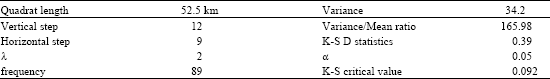
The coordinates of each archaeological site were stored in a spatial database. Two main attributes were also stored; the elevation above sea level in meters and the size in square kilometers for each site. To detect the spatial pattern of the Middle Bronze Age sites, Quadrat Analysis was used. This method examines how density of points changes over space. To check if the point distribution is more clustered or more dispersed than a generated random point pattern using Poisson Process (λ = average number of points per Quadrat), Kolmogorov-Simirnov test (K-S test) was used. Nearest Neighbor Analysis was also used to account for distances among sites in clustering. The spatial autocorrelation of sites was tested using the indices of Moran and Geary considering the weighted factors of elevation and size. We also employed the spatial statistics of the Mean Center, the Median Center and the Deviational Ellipse to find the directional bias in the distribution of the Middle Bronze Age sites.
RESULTS AND DISCUSSION
A regular square grid was overlain on the whole area of Jordan. The optimal Quadrat size was calculated following the formula of Griffith and Amrhein (1991):
A is the area of Jordan and n is the number of sites.
The number of Quadrats = 8955 6 km2/821.6 km2
89556 is the total area of Jordan in square kilometers and 218 is the total number of Middle Bronze Age sites (Fig. 1).
The generated random point pattern using Poisson Process has a λ value of 2, which is the number of points per Quadrat in the generated random point pattern.
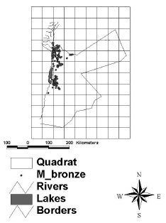 | |
| Fig. 1: | Quadrat grid superimposed on the Middle Bronze Age sites |
| Table 1: | The results of quadrat analysis using K-S D statistics |
 | |
| Table 2: | The results of Nearest Neighbor Analysis |
m is the number of Quadrats and n is the number of points.
The results of Quadrat analysis on the Middle Bronze Age Sites (Table 1).
The critical value of 0.092 is smaller than 0.39 indicating that the difference is statistically significant at α = 0.05 (Table 1). In Poisson Process, λ is the mean and also equals the variance indicating that the Variance/Mean ratio is equal to 1. In other words non-clustered point pattern should approach a value of 1 but in our example the Variance/Mean ratio is 165.98, which is very high indicating a clustered pattern of the archaeological site distribution during the Middle Bronze Age.
Quadrat Analysis does not take into consideration the distances among the archaeological sites but Nearest Neighbor Analysis compares the observed average distances between nearest neighbor sites and those of a known pattern. Nearest Neighbor Analysis (R) is calculated using the following formula:
Where Robs is the observed average distance and Rexp is the expected average distance as determined by the theoretical pattern.
To measure Robs, the software calculated the distance between each nearest neighbor site and all of its neighbor sites. The process is repeated for all sites and then the results were averaged. To measure Rexp, we use the following formula:
n is the number of points and A is the study area.
Table 2 displays the Nearest Neighbor Analysis for the Middle Bronze Age sites:
The more clustered pattern is associated with smaller R values (Robs‹ Rexp), while the more dispersed patterns are associated with large R values (Robs › Rexp). The R value in Table 2 is much smaller than 1 indicating the pattern is increasingly clustered.
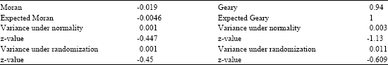
| Table 3: | Moran’s Index and Geary’s Ratio statistics using size as a weighted factor |
 | |
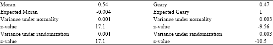
| Table 4: | Moran’s Index and Geary’s Ratio statistics using elevation as a weighted factor |
 | |
To confirm if R score is statistically significant it should be compared to ZR score, which is the standardize score and can be calculated using the following formula:
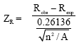 |
n is number of points and A is the area of study.
The result of ZR is 25.13, which is very high and higher than 1.96 threshold, so Middle Bronze Age sites are definitely clustered. Actually if ZR > 1.96 or ZR< -1.96, then the calculated difference between the observed pattern and the random pattern is statistically significant.
Although Quadrat Analysis and Nearest Neighbor Analysis detect the distribution pattern of the Middle Bronze Age sites both of them ignore other factors that might contribute to the clustering pattern proved previously. To test if the Middle Bronze Age sites share each other’s the same characteristics of elevation and size we used a statistical measure known as spatial autocorrelation coefficient. We performed Moran’s Index and Geary’s Ratio to measure the spatial autocorrelation among the Middle Bronze Age sites.
If Moran Index is lower than the Expected Moran then the distribution is dispersed or uniformed but if Moran Index is larger than the Expected Moran then the distribution is clustered. And if Geary’s Ratio is equal to 1 then the distribution is random; more than 1, the distribution is dispersed or uniform and lower than 1 the distribution is clustered. The Table 3 shows Moran-Geary statistics using the ‘size’ of the archaeological site as the weighted variable for clustering:
The z-value under normality and randomization is not greater than 1.96 and also not lower than -1.96 indicating that the calculated difference between the observed pattern and the random pattern using Moran’s I is statistically insignificant, thus eliminating the size of the site as a clustering factor. In Geary’s Ratio, the z-values in both normality and randomization fall between -1.96 and 1.96 indicating that the difference of the observed pattern and the random one is also statistically insignificant. Table 4 shows the results of Moran-Geary using elevation as a factor in clustering:
According to the results from Table 4, Moran Index is larger than the expected Moran Index indicating a clustered pattern and the difference is statistically significant under normality and randomization. And as far as Geary’s Ratio is lower than 1, it indicates a clustered pattern, which is statistically significant.
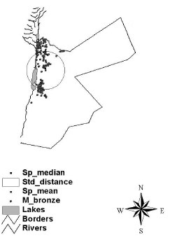 | |
| Fig. 2: | The mean center and deviational ellipse of the Middle Bronze Age sites |
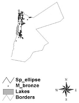 | |
| Fig. 3: | The deviational ellipse of the Middle Bronze Age sites |
Moran-Geary statistics point that the Middle Bronze Age sites in Jordan are apparently clustered and that these sites share each others similar elevations above sea level of about 600 m.
To find the average location of the Middle Bronze Age sites using elevation as a weighted factor, the Mean Center statistics was used and calculated by multiplying the x and y coordinates of each point by its elevation. The mean of the weighted x and weighted y coordinates defines the position of the weighted mean center. We also calculated the Median center of the Middle Bronze Age sites where the total distance from the Median center to each of the sites in the region is the minimum. Figure 2 shows the Median Center and Mean Center of the sites and both of them are in a very close proximity occupying a circle center of a diameter of about 68km. The circle shows the spatial spread of the Middle Bronze Age sites and ignores the presence of any directional bias. Directional bias occurs in response to a certain geographical phenomenon (Lee and Wong, 2001).
The Standard Deviational Ellipse was calculated by subtracting the x and y coordinates of all sites from the x and y coordinates of the Mean center and finally calculating the angle of rotation (Fig. 3).
The Fig. 3 shows that the x axis is longer than the y axis indication that the directional deviation is north-south. This deviation is parallel to the Jordan River indicating that the intention of the Middle Bronze Age people was to establish their settlements along the Jordan River. The right edge of the east-west axis approximately touches the precipitation isohyets of 500 mm. this indicates that the Middle Bronze Age sites were established within ample amounts of precipitation at elevations higher than 600 m above sea level.
ACKNOWLEDGMENTS
This study was financed by the TEMPUS project “Establishing A Heritage Center in Jordan” under the category of the “integrated concept of natural sciences and archaeology”, as a joint project between Yarmouk University/Jordan and Brandenberg Technical University/Germany supervised by Professor Ziad Al-Sa’ad and Professor Michael Schmidt, respectively.
REFERENCES
- Al-Saad, Z., 2000. Technology and provenance of a collection of islamic copper-based objects as found by chemical and lead isotope analysis. Archaeometry, 42: 385-397.
CrossRef - Jaber, N.A. and Z.A. Saad, 2000. Petrology of middle islamic pottery from khirbet faris. Jordan. Levant, 32: 179-188.
Direct Link - Harrison, T., 1997. Shifting patterns of settlements in the highlands of central jordan during the early bronze age. Bull. Am. School Oriental Res., 306: 1-37.
Direct Link - Khalil, L., 2001. Glass vesseles and miniature jugs from khirbit yajuz cemetery, Jordan. Levant, 33: 127-138.
Direct Link - Rollefson, G.O., 1983. Ritual and ceremony at neolithic Ain Ghazal (Jordan). Paleorient, 9: 29-38.
Direct Link - Rollefson, G.O., 1986. Neolithic Ain Ghazal (Jordan): Ritual and ceremony, II. Paleorient, 12: 42-52.
Direct Link - Rollefson, G.O., 1989. The aceramic neolithic of the Southern Levant : The view from Ain Ghazal. Paleorient, 15: 135-140.
Direct Link - Rollefson, G.O., 1998. Ain Ghazal (Jordan): Ritual and ceremony III. Paleorient, 24: 43-58.
Direct Link - Rollefsson, G.O., A. Simmons and Z. Kafafi, 1992. Neolithic cultures at Ain Ghazal Jordan. J. Field Archaeol., 19: 443-470.
Direct Link - Magablih, K. and A. Al-Shorman, 2004. Management and development of tourist sites in Jordan using geographic information system. Inform. Technol. Tourism, 6 : 287-295.
Direct Link