
Afaf M. Abd El-Hameed
National Research Institute of Astronomy and Geophysics (NRIAG), Helwan, Cairo, Egypt
Space Research Journal
Year: 2012 | Volume: 5 | Issue: 1 | Page No.: 10-14


ABSTRACT
The distance between two stations was supposed to be determined from two pairs of synchronous optical observations. In addition, the optical observations were studied and analyzed in combination with one laser measurement. The expressions for the error of this distance have been obtained" and "the minimum error conditions have been investigated.
PDF Abstract XML References Citation
Received: February 29, 2012;
Accepted: March 24, 2012;
Published: July 11, 2012
How to cite this article
Afaf M. Abd El-Hameed, 2012. The Accuracy of the Distance Between Two Stations using Synchronous Optical Observations of the Artificial Satellites in Combination with One Laser Measurement. Space Research Journal, 5: 10-14.
DOI: 10.3923/srj.2012.10.14
URL: https://scialert.net/abstract/?doi=srj.2012.10.14
DOI: 10.3923/srj.2012.10.14
URL: https://scialert.net/abstract/?doi=srj.2012.10.14
INTRODUCTION
In the previous studies, many authors considered that, the conditions at which the directions from one station to another was determined with the highest accuracy from synchronous optical observations (Batrakove, 1969; Lambeck, 1968; Zhongolovitch, 1970; Allan and Weiss, 1980; Liao, 1985). Also, GPS was used for determined the acceleration and torsion displacements data of a Yonghe bridge tower (Kaloop and Hui, 2009). In the previous study, GPS system was employed for solving the problem of mobile machine localization (Yuan et al., 2010). The system error of this kind of system was determined and corrected by lidar sensors. In this case, lidar scan-matching was proposed to correct the error of GPS to localize a mobile machine accurately.
Since, the laser measurements of the range to satellites became more accurate and wide spread. Laser optical devices were proposed for the surface detection on defect features concerning the past low speed, smaller size in detection and less inconvenience in the testing or operation (Chu et al., 2011). Also, laser optical observation was considered for illuminating artificial satellites and other space objects from H-SLR station with determined the accuracy of the calculations (Ibrahim et al., 2011). It was of interest to consider more general problem in which, besides the usual synchronous optical observations of two positions of the satellite from two stations, one measurement of the range was available (Gili et al., 2000; Hakli, 2004; Martin and Jahn, 2000; Eckl et al., 2001). Furthermore (Ekuma, 2007) considered the model, which describing the laser light and optical objects, for studying the infinite nature of most distant bodies. In addition, laser-satellite optical observations in SLR station were achieved for investigating and studying the effect of the satellite signatures on the data fitting accuracy (Hanna et al., 2011).
The analytical expressions for the error of the distance should be presented depending on errors of measurements. In addition, the problem of conditions, which give the minimum of this error, was taken in our consideration.
SYSTEM OF COORDINATES
For the sake of simplicity, we introduced the frame of reference in the following way seen in Fig. 1.
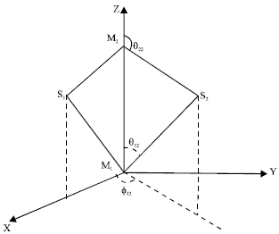 | |
| Fig. 1: | The system of coordinates M1: Station at the origin, M2: Station was laid on the Z-axis S1 and S2: Two successive positions of the satellite between the two stations |
The origin was placed at the first station M1, the Z-axis was passed through the second station M2. The XZ plane was passed through the first observed satellite S1 and Y-axis was completed the right hand system, with X and Z-axis.
In this frame of reference, the error of Z-coordinate of M2 station was equivalent to the error of the distance.
Vectors ![]() having origin at Mi station and the end at Sj satellite and ρij were topocentric distance (from the station to the satellite), θij, φij were angular coordinates of the satellite measured as seen from Fig. 1.
having origin at Mi station and the end at Sj satellite and ρij were topocentric distance (from the station to the satellite), θij, φij were angular coordinates of the satellite measured as seen from Fig. 1.
THE EQUATIONS OF CONDITION
From Fig. 1, we have:
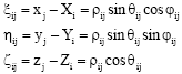 | (1) |
where, (xj, yj, zj) and (Xi, Yi, Zi); (j, i = 1, 2) are the coordinates of the satellite and station, respectively. Differentiation of (1), gives the equations of condition:
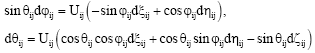 | (2) |
Where:
We must put in Eq. 2:
| (3) |
Besides, it must be taken into account that this problem could allow to determine only relative positions of satellites. In addition, the position of M1 station must be taken as known, this gives:
| (4) |
Now, with Eq. 4, we have nine unknowns, three coordinates for every position of the satellite and three coordinates of M2 station. However, it is possible to write only eight Eq. 2 types and it is necessary to add one more equation, which is given by the range measurements to these eight equations. Let us consider this measured distance to correspond to indices i = j = 1, such supposition do not break the generality, because every measured distance can be taken for ρ11 at the proper choice of the frame of reference. For the range measurement, we have the equation of condition, taking into account the conditions of Eq. 3 and 4:
| (5) |
Solving Eq. 1-5 with respect to the correction dZ2 as an example, we obtain after sufficiently troublesome computations, the following expression:
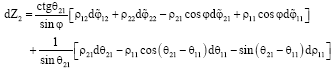 | (6) |
Where:
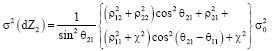
Let us suppose that ![]() , dθij are independent random values distributed according to the normal laws with the equal dispersion σ20 (σ20 is the square of the mean quadratic error of one measurement). The random value dρ11 is also considered to be independent and normal and its dispersion is taken to be χ2 σ20, where χ a coefficient is transforms the dimensions and the values of the angular errors into the dimensions and the values of the range error. The dispersion of dZ2 is determined by the formula:
, dθij are independent random values distributed according to the normal laws with the equal dispersion σ20 (σ20 is the square of the mean quadratic error of one measurement). The random value dρ11 is also considered to be independent and normal and its dispersion is taken to be χ2 σ20, where χ a coefficient is transforms the dimensions and the values of the angular errors into the dimensions and the values of the range error. The dispersion of dZ2 is determined by the formula:
 | (7) |
The mean square error of dZ2 can be obtained by computing the square root from the both parts of Eq. 7. Let us analyze now the expression (7), the second item of the right hand side of (7) does not depend on φ and the first item as can easily seen has minimum at sin2 φ = 1 which corresponds to the condition:
φ = π/2 |
It means that planes of synchronous observations must be perpendicular one to another. At sin2 φ = 1, then we have:
 | (8) |
where, the angles φ21 and (θ21-θ11) may be considered as naturally independent variables. The expression between brackets in the right hand side of Eq. 8 has minimum at cos2 θ21 = cos2 (θ21-θ11) = 0. It corresponds to sin2 θ21 = 1 (i.e., when sin2 θ21, is maximum).
In this case, we have the solution with physical meaning:
| (9) |
According to this solution, the first satellite must Zlace at the point M2. In this case ρ21 naturally is equal to zero. Finally, we obtained the following minimum dispersions of dZ2:
CONCLUSION
The received conditions from Eq. 9, gave very small error in determining the distance between two stations. It was evident that we could speak only about the approximation to these ideal conditions, which were allowed by the visibility conditions and by the requirement of the negligibility of differential refraction effect, which influence the determination of the position noticeably at small angles above the horizon.
REFERENCES
- Ekuma, E.C., 2007. Spatiotemporal nature of scattered laser light and its application. Res. J. Phys., 1: 60-63.
CrossRefDirect Link - Eckl, M.C., R.A. Snay, T. Soler, M.W. Cline and G.L. Mader, 2001. Accuracy of GPS-derived relative positions as a function of interstation distance and observing-session duration. J. Geod., 75: 633-640.
Direct Link - Chu, H., Z. Xie, X. Xu, L. Zhou and Q. Liu, 2011. Inspection and recognition of generalized surface defect for precise optical elements. Inform. Technol. J., 10: 1395-1401.
CrossRef - Gili, J.A., J. Corominas and J. Rius, 2000. Using Global Positioning system techniques in landslide monitoring. Eng. Geol., 55: 167-192.
CrossRefDirect Link - Lambeck, K., 1968. Scaling a satellite triangulation net with laser range measurements. Stud. Geophys. Geod., 12: 339-349.
CrossRefDirect Link - Liao, D., 1985. Determination of the distance between two adjacent stations, the observational vertical increment and the observational time interval in optimum sense. Adv. Atmos. Sci., 2: 316-324.
CrossRef - Ibrahim, M., A.M. Abd El-Hameed and G.F. Attia, 2011. Analytical studies of laser parameters for ranging and illuminating satellites from H-SLR station. Space Res. J., 4: 71-78.
CrossRefDirect Link - Kaloop, M.R. and H. Li, 2009. Tower bridge movement analysis with GPS and accelerometer techniques: Case study yonghe tower bridge. Inform. Technol. J., 8: 1213-1220.
CrossRefDirect Link - Martin, S. and C.H. Jahn, 2000. Experiences in set-up and usage of a Geodetic real-time differential correction network. Earth Planets Space, 52: 851-855.
Direct Link - Yuan, X., C.X. Zhao and Z.M. Tang, 2010. Lidar scan-matching for mobile robot localization. Inform. Technol. J., 9: 27-33.
CrossRefDirect Link - Hanna, Y.S., M. Ibrahim and S.W. Samwel, 2011. Spline and overlap techniques for analyzing slr data. Space Res. J.
Direct Link