
Reza Kabiri
University of Nottingham Malaysia Campus, Selangor, Malaysia
Research Journal of Environmental Sciences
Year: 2014 | Volume: 8 | Issue: 4 | Page No.: 178-192


ABSTRACT
Loss models calculate the interception and infiltration rate in the watershed to indicate rainfall loss in surface runoff simulation. As such, the loss rainfall amount depends on soil types, landuse and antecedent condition. The study aims to specify the results of SCS-CN loss model to estimate runoff in Klang watershed on long time daily rainfall data. The daily time-series of the 23 rainfall gauges were entered into the meteorological model to develop hydrograph at the sub-basins. In this study, two steps have been conducted to simulate the hydrologic modelling using HEC-HMS in Klang watershed. Initially, the watershed was divided into homogeneous sub-basins using Hec-Geo-HMS to get the sub-basin geometric data and then, the hydrological modelling was developed in HEC-HMS for the watershed using all the parameters obtained from the previous step. Modified SCS-CN loss method was performed by changing in amount of initial abstraction ratio into 0.05 in the watershed to estimate the accuracy of calibration and validation results of hydrology model. Although, flood hydrograph is best calibrated for peak discharge with the modified ratio of initial abstraction to maximum potential retention in SCS model, the results revealed that initial abstraction (λ = 0.05) and CN0.05 of daily rainfall by percent error in peak have given no significant difference results rather than initial abstraction with 0.2 value and CN0.2, because using CN0.05 for loss model, the simulated flows are underestimated to observed discharges equal to 23.6 and 13.49% for calibration and validation periods, respectively.
PDF Abstract XML References Citation
Received: April 24, 2013;
Accepted: October 28, 2013;
Published: April 12, 2014
How to cite this article
Reza Kabiri, 2014. Simulation of Runoff using Modified SCS-CN Method using GIS System, Case
Study: Klang Watershed in Malaysia. Research Journal of Environmental Sciences, 8: 178-192.
DOI: 10.3923/rjes.2014.178.192
URL: https://scialert.net/abstract/?doi=rjes.2014.178.192
DOI: 10.3923/rjes.2014.178.192
URL: https://scialert.net/abstract/?doi=rjes.2014.178.192
INTRODUCTION
Loss models calculate the interception and infiltration rate in the watershed to indicate rainfall loss in surface runoff simulation. There are various methods to simulate surface runoff using different loss model methods such as the SCS Curve Number model (USDA-SCS, 1985), CASC2D (Marsik and Waylen, 2006), TOPMODEL (Warrach et al., 2002), GIUH (Kumar et al., 2007), University of British Columbia Watershed Model (UBCWM) and Geomorphological Instantaneous Unit Hydrograph (GIUH).
HEC-HMS (USACE, 2000) provides various methods to calculate the loss rate in the basin/sub-basin such as Deficit and constant, exponential loss, Green-Ampt, SCS Curve Number, initial and Constant. Among the methods, the SCS-CN method is widely used. Akbari et al. (2012) have investigated the assessment of the SCS-CN loss method in Klang watershed to evaluate the performance of the SCS-CN loss method. They concluded that the SCS-CN loss method can be used for Klang watershed due to its good agreement between observed and modelled in HEC-HMS. However, they suggested a modified CN using initial abstraction ratio in value of 0.05 gives a better fit than 0.2 (as default in HEC-HMS). Abood et al. (2012) have evaluated the performance of the two infiltration methods (SCS-CN and Green-Ampt) in rainfall-runoff simulation using HEC-HMS for the kenyir and Berang catchment, Terengganu, in Malaysia. Calibration and validation of the HEC-HMS used of storm events of September and October, 1990 and November and December, 1990, respectively. They found that the both loss methods have a good agreement with the observed data. However the SCS-CN method was recommended for the watersheds due to its high accuracy in the modelling results.
In this study, modified SCS Curve Number method is applied to determine loss model as a major component in rainfall-runoff modeling. The objective of this study is to specify the results of SCS-CN loss model to estimate runoff in Klang watershed on long time daily rainfall data.
MATERIALS AND METHODS
Study area: Klang watershed located on the west coast of Peninsular Malaysia. Klang is situated in Kuala Lumpur, Selangor province in Malaysia as Fig. 1. Since the city is situated on confluence of Klang and Gombak rivers there has been crucial to manage environmental management of the basin particularly through the system drainage to channel the flow river out the city.
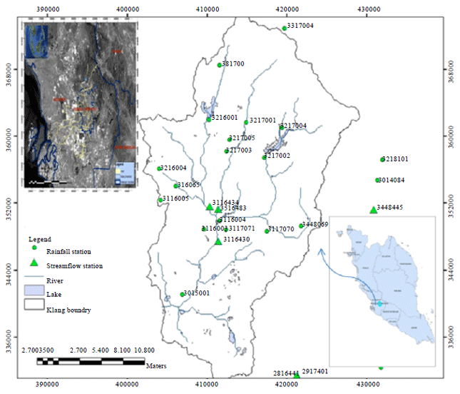 | |
| Fig. 1: | Location of the rainfall and river flow stations used in Klang watershed |
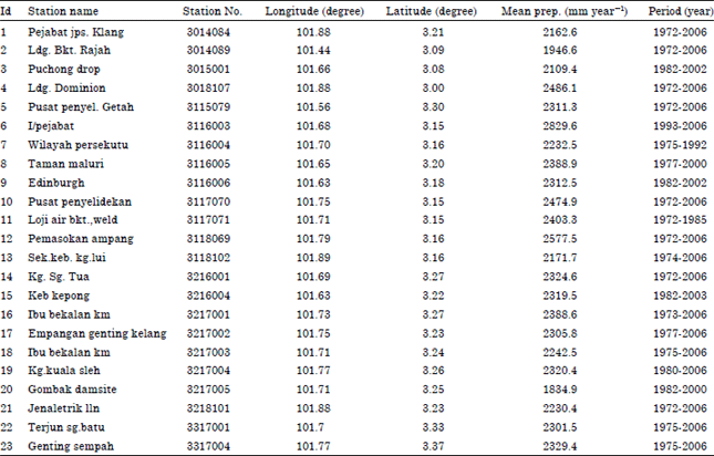
| Table 1: | Geographical characterizations and the mean annual rainfall values of the meteorological stations |
 | |
The middle part of Klang watershed has a high proportion of impervious urban area (about 50%) and much of it is perched on susceptible land to flooding. Precipitation over the catchment averages about 2350 mm. The most significant heavy precipitation had been observed during the months of October, November and December (Desa and Niemczynowicz, 1996).
Data used: Land use, soil data, digital topo-sheets at the scale of 1:25,000 and the historic climate data records such as Rainfall, Temperature, Evaporation and hydrometric data needed for hydrology modeling, have been acquired from Department of Irrigation and Drainage of Malaysia (DID). The 23 rainfall gauges have been selected covering Klang watershed which is shown in the Table 1 presenting the geographical coordination, name, Id number, the year period and mean of rainfall of the rainfall over the years specified gauge stations used in the study area.
Methodology: The SCS-CN loss method is used in runoff estimation to specify the amount of infiltration rates of soils. The method uses an integration of landuse and soil data to determine CN values of the watershed. The CN values were adopted from Technical Release 55 (USDA-NRCS, 1986). In this regard, soils are categorised into hydrologic soil groups (HSGs). The HSGs consists of four categories A, B, C and D which A and D are the highest and the lowest infiltration rate, respectively.
In this study, two steps have been conducted to simulate the hydrologic modelling using HEC-HMS in Klang watershed. Initially, the watershed was divided into homogeneous sub-basins using Hec-Geo-HMS to get the sub-basin geometric data and then, the hydrological modelling was developed in HEC-HMS for the watershed using all the parameters obtained from the previous step. The rainfall-runoff (USACE, 2000) hydrologic model was used to predict runoff in the watershed. The rainfall-runoff model takes into account the influences of physical parameters of the watershed such as climatic, topography, landuse and soil data representing the boundary condition over the watershed to simulate runoff. The hydrological soil type was derived from soil data and combined to the landuse data to generate the SCS-CN loss rate. Modified SCS-CN loss method was performed by changing in amount of initial abstraction ratio into 0.05 in the watershed to estimate the accuracy of calibration and validation results of hydrology model.
Watershed modelling: The hydrology parameters needed in the rainfall-runoff modelling were generated using Hec-Geo-HMS. The data layers have been driven from the watershed physical characteristics include basin area and perimeter, length of the river, mean elevation and slope, rainfall loss coefficient, lag time, land use and soil unites as influence the runoff hydrograph. These hydrological parameters could be generated automatically by GIS system using Hec-Geo-HMS for each sub-basin of Klang. Thus, runoff processes are simulated on each sub-basin system from the upstream to the watershed outlet throughout the streamflow network. These hydrological parameters are driven automatically by GIS system using Hec-Geo-HMS for the watershed.
Runoff modelling: The detailed method of hydrology modelling in HEC-HMS can be founded by Ford et al. (2008) and Scharffenberg and Fleming (2008). It estimates the rainfall losses infiltrates by the ground. To develop the CN map, the soil data of the Klang watershed has been categorized into Hydrologic Soil Groups (HSGs) and then have been combined with landuse data. CN map indicates the integrated landuse-soil of the of Klang watershed. The relevant equations listed below:
| (1) |
| (2) |
| (3) |
where, Q is direct runoff (mm), P is accumulated rainfall (mm), S is potential maximum soil retention (mm) and CN is Curve Number.
Modified CN: Sensitivity analysis was performed to estimate the accuracy of calibration and validation results of hydrology model. Many studies have conducted sensitivity analysis in HEC-HMS to tackle the calibration error. Optimization was performed by changing in amount of initial abstraction ratio (λ) into 0.05 in Klang watershed (Akbari et al., 2012) and consequently changes in the curve number values for all the sub-basins.
Since in this study the CN method has been used for estimation of losses, sensitivity analysis is performed to determine the effective parameters for calibration of the loss model to achieve better results. Once running the daily and monthly simulations in HEC-HMS, sensitive parameters of CN model were specified to create optimization for calibration period in HEC-HMS. Since a large number of data are put into the rainfall-runoff model, the two parameters include curve number and initial abstractions are used for sensitivity analysis in HEC-HMS. The analysis was optimized according to objective functions of peak weighted root mean square.
Woodward et al. (2003) developed the equation to convert CN to CN0.05. The Eq. 4 assumes the potential soil storage equivalent to initial abstraction (λ = 0.05) as the Eq. 4:
| (4) |
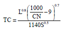
Time of concentration: The standard lag time is defined as the length of time between the centroid of precipitation mass and the peak flow of the hydrograph. For application in HEC-HMS, the parameter of the time of concentration is necessary. This can be estimated by getting the time between the centroid of the storm and the inflection point of the hydrograph or via calibration. Hydrograph represents the changes in runoff through the time. In this study, SCS dimensionless hydrograph was used to generate hydrograph for a long time daily rainfall over Klang watershed. The parameters of the method are: Time of concentration, lag time, Duration of the excess rainfall, Time to peak flow, Peak flow. The relevant equations are defined as:
| (5) |
 | (6) |
| (7) |
where, Tp is time to peak (min), TC is time of concentration (h), L is hydraulic length of watershed (ft), S is average land slope of the watershed (percent), qp is peak flow (m3 sec-1), Q is direct runoff (cm), A is area of watershed (km2) and Tp is time to peak (h).
Meteorological model: To define the meteorological model in HEC-HMS for Klang watershed, the gauge weight method was used to allocate the climatic parameters for each sub-basin (Meenue et al., 2012). The daily time-series of the 23 rainfall gauges were entered into the meteorological model to develop hydrograph at the sub-basins. The meteorological model used Monthly average Evapo-Transpiration (ET) method for the rainfall-runoff simulation. The empirical Hargreaves method (Salazar et al., 1984) was used to calculate the ET. It is based on the air temperature and requires the maximum and minimum air temperature to calculate ET. Many studies have shown the role of the Evapo-Transpiration into hydrology modelling (Zhao et al., 2013; Milly and Dunne, 2011). This method was used as its simplicity and modest data requirement which made it attractive for the hydrology modelling (Hargreaves and Samani, 1985) Eq. 8 is described as below:
| (8) |
where, Tm is Daily mean air temperature (°C), it is equivalent to Tmax+Tmin/2, Tmax is Daily maximum air temperature (°C), Tmin is Daily minimum air temperature (°C), Ra is Extraterrestrial radiation in equivalent evaporate on in mm day-1. The mean air temperature in the Hargreaves equation is calculated as an average of Tmax and Tmin.
RESULTS
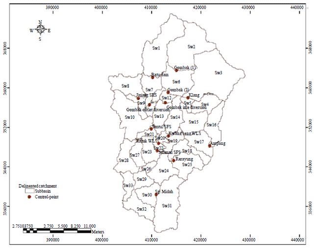
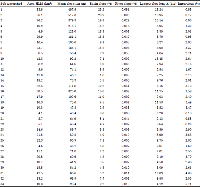
Generating hydrological watershed characterization: Catchment delineations have been driven for Klang watershed to extract hydrological parameters using as input into HEC-HMS hydrology model. The SCS-CN loss method in HEC-HMS needs the data such as CN, initial abstraction, potential soil storage and impervious. These data have been developed using GIS spatially. Figure 2 shows the catchment delineation of elevation map driven by HEC-GEO-HMS along with the benchmark points used for optimization of delineated sub-watershed. The physical catchment characteristics such as catchment area, perimeter, catchment length and slope were automatically calculated in HEC-GEO-HMS (Table 2).
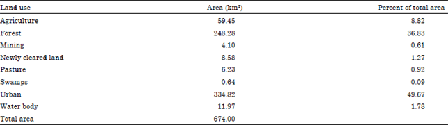
Determining CN and Modified CN: USGS land use classification of Klang watershed was developed as Table 3. The USGS codes added to the land use’s attribute in GIS.
 | |
| Fig. 2: | Automatic catchment delineation of raw elevation map in GIS system. Red points are the benchmark points used for optimization of delineated sub-wastershed |
| Table 2: | Physical characteristics of Klang watershed |
 | |
| Table 3: | Land use classes present in the Klang watershed |
 | |
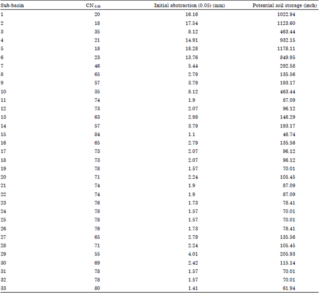
| Table 4: | CN0.05 values for each sub basin in Klang watershed |
 | |
Soil type as one of the significant layer affecting rainfall loss were classified based on Soil Group Classification (SCS) system. USACE (2000) provides the Curve Number (CN) value for the different landuse considering the four soil groups. In order to construct the CN value of Klang watershed, two landuse and soil layer in GIS were overlaid. Figure 3 illustrates the overlaid map of the landuse and soil layers indicating CN values.
The Curve number parameters for using in sensitivity analysis are calculated based on the CN0.05 as given in Table 4. The value of the two parameters (CN and Initial abstraction) changed to determine their effects on peak discharge of flood. Results revealed that initial abstraction (λ = 0.05) and CN0.05 of daily rainfall by percent error in peak have given no significant difference results rather than initial abstraction with 0.2 value and CN, because using CN0.05 for loss model, the simulated flows are underestimated to observed discharges equal to 23.6 and 13.49% for calibration and validation periods, respectively.
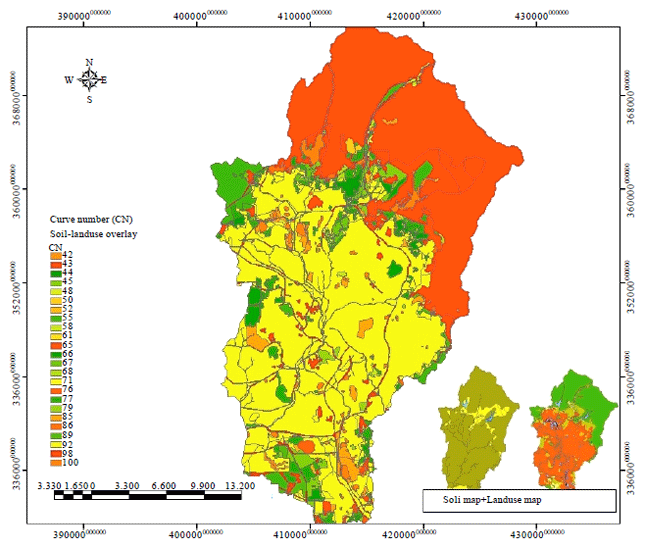 | |
| Fig. 3: | Curve No. (CN) map of Klang watershed |
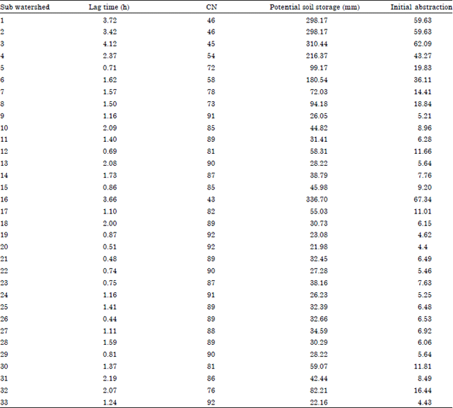
SCS unit hydrograph transform: The standard shape was employed in HEC-HMS to define the shape of the unit hydrograph. In this method the standard lag is defined as the length of time between the centroid of precipitation mass and the peak flow of the resulting the hydrograph. Basin lag is considered as 0.6 times the time of concentration of the flow. Table 5 gives the lag time, potential soil storage and initial abstraction calculated for each sub basin of Klang watershed.
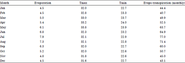
Meteorological model: The meteorological model used Monthly average Evapo-transpiration (ET) method for the rainfall-runoff simulation. The daily evaporation from Batu dam station for the years (1985-2001) was used. The empirical Hargreaves method (Salazar et al., 1984) was used to calculate the ET. It is based on the air temperature and requires the maximum and minimum air temperature to calculate ET. Table 6 shows the daily and monthly ET calculated for the Batu dam station. The 17 years (1985-2001) daily evaporation time series in the Batu dam station was used.
Model calibration and validation: The daily rainfall data for the 23 rainfall gages through the long period were used for calibration and validation of HEC-HMS simulation for Klang watershed.
| Table 5: | Hydrologic parameters of Klang watershed |
 | |
| Table 6: | Calculation of the daily and monthly evapo-transpiration values for year period (1985-2001) |
 | |
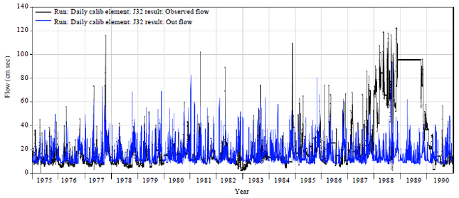 | |
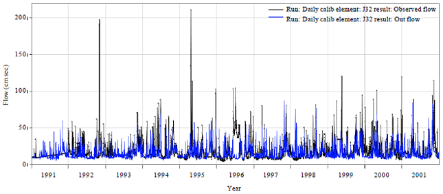
| Fig. 4: | Calibrated result of observed and simulated daily discharge at the sulaiman streamflow during the calibration period (1975-1990) |
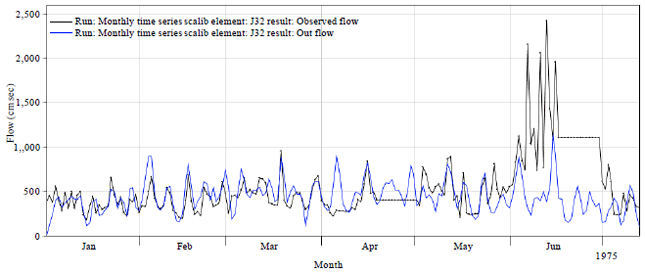 | |
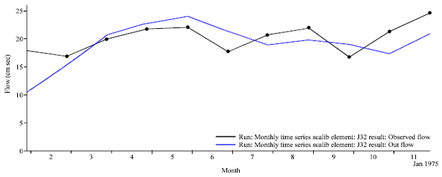
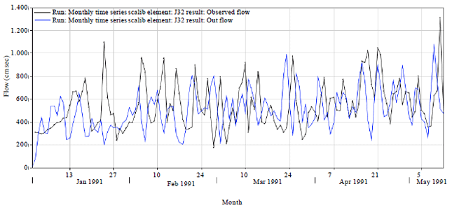
| Fig. 5: | Simulated monthly discharge at the sulaiman streamflow during the calibration period (1975-1990) |
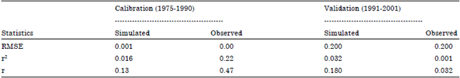
The numbers of 16 years (from 1975-1990) were selected for the calibration and the 11 year lengths from 1991-2001 for the validation in HEC-HMS program as the same period calibration and validation of rainfall downscaling in SDSM. Figure 4-9 shows the calibration and validation test in HEC-HMS. Some statistical efficiency criteria are used to perform evaluation of the calibration and validation results between model outputs and observed data which are Root mean square error (RMSE), Coefficient of determination (r2) and Correlation coefficient (r) to indicate the goodness of fit between simulated and observed data.
The calibration of the rainfall-runoff model in HEC-HMS for Klang watershed is performed by comparing the modelled daily streamflows with the observed flow at the Sulaiman discharge gauge.
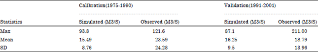
Table 7 gives the statistics of the daily observed and modelled streamflow at the Sulaiman discharge station for the calibration and validation periods. As the table, maximum and mean values of daily flows are underestimated during calibration and validation periods.
 | |
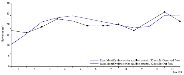
| Fig. 6: | Simulated average monthly discharge at the sulaiman streamflow during the calibration period (1975-1990) |
 | |
| Fig. 7: | Simulated daily discharge at the sulaiman streamflow during the calibration period (1990-2001) |
| Table 7: | Statistics of the observed and simulated daily flows at the sulaiman station during calibration and validation |
 | |
The plots of daily and monthly flow modelling are illustrated in figures indicate that flows are well simulated. However most of daily high flows simulated in calibration and validation periods are underpredicted. Then it was attempted to estimate the magnitude of underprediction of high flows using sensitivity analysis to address the uncertainty involved in the modelling.
 | |
| Fig. 8: | Simulated monthly discharge at the sulaiman streamflow during the calibration period (1990-2001) |
 | |
| Fig. 9: | Simulated average monthly discharge at the sulaiman streamflow during the calibration period (1990-2001) |
The discrepancy of daily flow modelling at the Sulaiman streamflow station has already been observed by Kavvas et al. (2006).
Table 8 gives the performance assessment for the daily and monthly discharges in the calibration and validation periods. The calibration and validation results represented a good fit between the observed and simulated daily discharges. Thus it can be concluded that HEC-HMS model responds well in simulation of hydrological processes in Klang watershed using meteorological observation data.
The value of the two parameters (CN and Initial abstraction) changed to determine their effects on peak discharge of flood. Results revealed that initial abstraction (λ = 0.05) and CN0.05 of daily rainfall by percent error in peak have given best results rather than initial abstraction with 0.2 value and CN. However, there has no significant differences between two CN and CN0.05.
| Table 8: | Performance assessment of hydrology model at the Sulaiman station during calibration and validation |
 | |
Using CN0.05 for loss model, the simulated flows are underestimated to observed discharges equal to 23.6 and 13.49% for calibration and validation periods, respectively.
CONCLUSION
In order to determine the efficiency and suitability of modified CN loss method used there has been attempted to make estimation on the results by some correlation coefficients and error indices. Although the characteristics of the hydrological watershed used in the rainfall-runoff modelling in Klang watershed are assumed constant throughout the simulation period. The results revealed that initial abstraction (λ = 0.05) and CN0.05 of daily rainfall by percent error in peak have given no significant difference results rather than initial abstraction with 0.2 value and CN0.2, because using CN0.05 for loss model, the simulated flows are underestimated to observed discharges equal to 23.6 and 13.49% for calibration and validation periods, respectively. Flood hydrograph is best calibrated for peak discharge with the modified ratio of initial abstraction to maximum potential retention in SCS model. Therefore, CN0.05 can be used for runoff simulation of SCS method in Klang watershed.
REFERENCES
- Akbari, A., A. Samah and F. Othman, 2012. Practical use of SRTM digital elevation dataset in the urban-watershed modeling. J. Spatial Hydrol., Vol. 10.
Direct Link - Desa, M.N. and J. Niemczynowicz, 1996. Spatial variability of rainfall in Kuala Lumpur, Malaysia: Long and short term characteristics. Hydrol. Sci. J., 41: 345-362.
Direct Link - Hargreaves, G.H. and Z.A. Samani, 1985. Reference crop evapotranspiration from temperature. Applied Eng. Agric., 1: 96-99.
CrossRefDirect Link - Marsik, M. and P. Waylen, 2006. An application of the distributed hydrologic model CASC2D to a tropical montane watershed. Hydrology, 330: 481-495.
CrossRefDirect Link - Meenue, R., S. Rehan and P.P. Mujumdar, 2012. Assessment of hydrologic impacts of climate change in Tunga-Bhadra river basin, India with HEC-HMS and SDSM. Hydrol. Processes.
CrossRef - Milly, P.C.D. and K.A. Dunne, 2011. On the hydrologic adjustment of climate-model projections: The potential pitfall of potential evapotranspiration. Earth Interact., 15: 1-14.
CrossRefDirect Link - Warrach, K., M. Stieglitz, H.T. Mengelkamp and E. Raschke, 2002. Advantages of a topographically controlled runoff simulation in a soil vegetation atmosphere transfer model. J. Hydrometeorol., 3: 131-148.
CrossRefDirect Link - Zhao, L., J. Xia, C.Y. Xu, Z. Wang, L. Sobkowiak and C. Long, 2013. Evapotranspiration estimation methods in hydrological models. J. Geog. Sci., 23: 359-369.
CrossRefDirect Link - Kumar, R., C. Chatterjee, R.D. Singh, A.K. Lohani and S. Kumar, 2007. Runoff estimation for an ungauged catchment using geomorphological instantaneous unit hydrograph (GIUH) models. Hydrol. Process., 21: 1829-1840.
CrossRefDirect Link