
R.K. Mandal
Economics, Dera Natung Government College, Itanagar-791 113, Arunachal Pradesh, India
Research Journal of Environmental Sciences
Year: 2012 | Volume: 6 | Issue: 1 | Page No.: 14-25


ABSTRACT
The study examined the dependency and to document the existing state of the indigenous community of Arunachal Pradesh, the 13th geographically largest State of India on local natural Common Property Resources (CPRs) such as village pasture, community forest, waste land, common thrashing grounds, watershed drainages, village ponds, tanks, rivers, rivulets and river bed, etc. for their livelihood. The decline of CPRs as shown by field evidence is closely associated with the depletion of this social capital. Despite a rapid decline in productivity, common property resources constitute an important component of community assets of India. Occupational structure in the state varying from primitive and indigenous agricultural practices with an inbuilt knowledge system initiates traditional occupational engagements in activities like hunting and gathering, shifting cultivation (slash and burn method) and collection of minor forest produce as well as earning from their inbuilt management system of natural resources.
PDF Abstract XML References Citation
Received: October 27, 2011;
Accepted: December 20, 2011;
Published: February 15, 2012
How to cite this article
R.K. Mandal, 2012. Proximate Relationship of Indigenous Communities with Natural Common Property Resources in Arunachal Pradesh of India: An Empirical Study of Tawang District. Research Journal of Environmental Sciences, 6: 14-25.
DOI: 10.3923/rjes.2012.14.25
URL: https://scialert.net/abstract/?doi=rjes.2012.14.25
DOI: 10.3923/rjes.2012.14.25
URL: https://scialert.net/abstract/?doi=rjes.2012.14.25
INTRODUCTION
The Common Property Resources (CPRs) is defined as the resources accessible to the whole community of a village and to which no individual has an exclusive property right. Examples of such CPR are village pasture, community forest, waste land, common thrashing grounds, watershed drainages, village ponds, tanks, rivers, rivulets and river bed, etc. These resources are of great importance in the economy of the rural poor (Jodha, 1985a, b). However, these resources have seldom received enough attention of the economic planners and policy makers. As a result these resources are shrinking and eroding as well. CPRs are resources over which a community has traditional access. These may include village pastures, forests, wastelands, irrigation systems and such other commodities having collective utilization. Such resources are accessible to the whole village community and no one person can stake his own preclusive claim. But, unlike open access resources where people’s use is on a “free rider” basis with no recognized property rights, in CPRs accessibility is exclusive with only the identified community having access to it and not others (Jodha, 1991, 1992, 1995). The decline of CPRs as shown by field evidence is closely associated with the depletion of this social capital. The consequence has been the conversion of CPRs in to open access resources and their rapid degradation despite efforts to protect and conserve them through special programmes, subsidies and enlarged bureaucracy. Despite a rapid decline in productivity, common property resources constitute an important component of community assets of India (Blaikie et al., 1985). In this study, communities are taken as relatively self-contained residential units while a group is a self-identified set of persons having some common interest (Uphoff, 1986). Many local communities/ groups are those native people who have close cultural attachment and economic dependence upon ancestral lands or upon lands to which they have been pushed by dominant groups. Such local communities/groups include the following:
| • | People organized into tribes having local descent group lineages and clans |
| • | Castes, where castes indicate occupational positions in social stratifications based on heredity |
| • | Ethnic minority groups which differ by race, religion, dialect, culture etc |
| • | Other local communities living in forest areas and dependent on local forests, trees and CPRs for livelihood |
This study includes all the categories of Indigenous communities/ groups, described above, who belong naturally to forest land and those who live in and around forest and are dependent on forest habitat and other local natural resources for their livelihood.
Livelihood in rural areas seems to offer both a more complete and compound picture of the complexities of survival in low income region than the terms earlier considered adequate such as ‘subsistence’, ‘income’ and ‘employment’. It comprises the assets (natural, physical, human, financial and social capital), the activities and the access to these (mediated by institutions and social relations) and together determine the living and well being gained by individual or household. Occupational structure in the state varies from primitive and indigenous agricultural practices with an inbuilt knowledge system initiates traditional occupational engagements in activities like hunting and gathering, shifting cultivation (slash and burn method) and collection of minor forest produce, to self employment, wage labour in agriculture and service sector as well as earning from their inbuilt management system of natural resources. These are some of the diversified livelihood options which portray a unique pattern in the rural-urban set up and comprise the major livelihood options that are available to the local populace at large giving a unique pattern of traditional base with transitional outlook towards continuity and change to modernity.
Level of living throws light on the economic well-being of the people. It tells us about individual, society, village, state or nation, its level of affluence and subsistence. This study, it is hoped, would throw light on the existing levels of living of tribal people and their mode of living habits depending on the natural common property resources. To facilitate this research work the study was largely based on the data collected from the primary source.
The specific objectives of the study are:
| • | Document the existing state of livelihood pattern of indigenous communities based on natural CPRs |
| • | To quantify their level of dependency on access to CPRs |
MATERIALS AND METHODS
Geographical area under study: Arunachal Pradesh is fortunate to have immensely rich biodiversity and natural resources with a forest cover exceeding 80% of its area. Equally pressing is the need for development of our peace loving people so as to catch up with the rest of our brethren in the country. There is, therefore, urgent need to harmonize the interest of environment with that development so that whatever we do is environmentally and socio-culturally sustainable. This state is situated near the tropic of cancer, lying between latitudes 26° 28’N and 29° 30’ N and longitude between 91° 30’ E and 97° 30’ E on the North-East extremity of India. It is bestowed by nature with beautiful ranges of snow-clad Himalayan peak which is locally called as paradise on the earth resulted in enormous ecological and floristic diversity. The State is bounded on the North, North-East and North-West by China (Tibet) on the South by Assam and Nagaland states on the South-East by Myanmar and on the West by Bhutan. The international border of the state runs from one tri-junction of Tibet (China), Bhutan and India in the north-west to another tri-junction of China, Myanmar and India in the northeast along with high peaks of the Himalayas of more than 1500 km in length. The great Himalayan ranges run from the east of the Bhutan Himalayas to the Tsangpo upto Mishmi hills. The land and topography of the state is hilly beginning from foothills to snow-clad zones of alpine region. The elevation of the hills ranges from 150 m to over 7,300 m. The State has 83,743 km2 area covering around 2.5% of the total geographical area of the country and bearing only 0.11% of its population with population density 17 km-2 as per 2011 census. Out of its area topographically, the plains and foothills cover about 10-15%, broad valleys and plateaus about 35%, steep slopes 35%, snow clad peaks and pastoral land 18-20%. There are 110 tribes living in the State. The flora and fauna that occur in the forests present a panorama of biological diversity with over 5000 plants, about 85 terrestrial mammals, over 500 birds and a large number of butterflies, insects and reptiles. Such an unparalleled occurrence of life forms can be attributed to the peculiar location of the State. The State offers an ideal agro climate with vast potentials for growing varieties of orchids round the year. Out of about 1150 species of orchids known in India, about 500 species occur in the State making it an ‘Orchid Paradise’ of our country (Mandal, 2006). There are over 500 Herbs recorded from the State of which 250 are used in various Ayurvedic formulations (Mandal, 2008). The state is very rich in having flora. It has about 4500 species of flowering plants, 400 species of pleridophytes, 23 species of coniferous, 35 species of bamboos, 20 species of canes, 25 Rhododendron species. Overall, Arunachal Pradesh is, as if, a natural garden of more than 20,000 identified species of medicinal plants and so many still remain unidentified. The rank of hotspot of the State has reduced from 18th to 21st at present in the world (Mandal, 2007).
Tawang is one of 16 districts of the State. The district has 9 circles under 3 blocks. Out of 9 circles, 3 circles (administrative units) viz. Mukto, Lumla and Zemithang along the international boundaries of Tawang district with China (Tibet) and Bhutan were considered as geographical area under study. The distance of Mukto from Tawang (Head Quarter) is 90 km, that of Zemithang from Tawang via Lumla is 70 kms and that of Lumla from Tawang is 50 km. Again, the distance between Lumla and Zemithang is 20 km. These three administrative units are connected by black top road. The vehicles are running. Zemithang has international boundary with China while Mukto and Lumla have international boundary with Bhutan.
To reach international boundary with China from Zemithang takes three hours by vehicle and also to reach international boundary with Bhutan from Lumla and Mukto takes two days foot march and one day foot march, respectively.
These 3 administrative units along the international boundaries were considered because the livelihood pattern of the people of these three units is primitive type and depends more on common property resources. Globalization and modern live style were not seen in this coldest area of the state. The three basic needs of life: food, cloth and shelter are managed by their own production on the basis of community cooperation.
Data base
Village survey: Three villages of each circle, which contains more population, was selected for survey and 50 households from the three villages were selected through random sampling technique without replacement to fill up the pre-designed questionnaire through direct interaction with respondents, i.e., 50 households from each circle. Total respondents of 3 circles were 150 (50x3 = 150).
Out of 50 households from each village consisted 25 from poor and 25 from non-poor. Again out of 25 households 10 were male respondents and 15 were female respondents. We gave more weightage on female, because generally females are engaged in collection of CPRs or forest produce. The researcher selected the respondents of age group (20-50) years as this age group is particularly more responsible to earn the livelihood for their family. The village survey was taken in the month of August, 2009.
It was categorized all households into two different household groups namely poor and non-poor based on the criteria as to what the villagers consider as important for assessing an individual’s socio-economic position in the village. The household who possesses 5 or below 5 acres land with no other alternative activities such as job, business, etc. was considered as poor and others were considered as non-poor.
Tools: Simple numerical calculations, graphical representations, different statistical and econometric tools like mean, standard deviation, coefficient of variation, Yule,s Coefficient of Association are used to analyse the data.
RESULTS AND DISCUSSION
To document the existing state of livelihood based on natural common property: Critical Role of Wild Food: The villagers consumed a variety of seasonal wild items of food gathered from different sources depending on their availability. The deficit in the staple item of food consumption was made good (at least partially) by food collected from the forests, common property resources, rivers and the ponds and by other items, some of which were even procured from the market. Availability of such food from the market was dependent on their purchasing power which was quite low. Most of these sources of food consumption could not fully compensate for the fall in the quality of food due to fall in availability of rice. Production of rice was very low in the study area as well as in the district of Tawang.
Local communities and forests, trees and CPRs: Local communities have historical ties with local forests, trees and CPRs which provide both direct and indirect benefits to them (Neela, 1997). In this section, the benefits of local communities from forests, trees and CPRs have been listed as described by community members in different participatory sessions. The benefits provided by such natural resources are basic to such communities and amongst direct benefits, the following arc included:
| • | Food such as nuts, wild fruits, vegetables, leaves, flowers, roots, stems, honey, wild animals, insects, etc |
| • | Habitat and shelter |
| • | Raw materials like bamboo, canes, fibres, oils, bhabbar grass, waxes, resins, gums, dyes and wood for furniture and capital equipment for agriculture, etc. |
| • | Wood for building, fencing, tool making etc. |
| • | Fuel wood |
| • | Medicines and drugs |
| • | Fodder such as grass, branches, twigs and leaves |
| • | Grazing sites |
| • | Means of livelihood, both seasonal and annual |
| • | Shade |
| • | Ornaments, religious items and cultural symbols |
Benefits-a mixed bag: The bounties of forest, trees and CPRs are a mixed bag. Table 1 provides an illustration of such a mixed bag where tribal villagers have listed multiple uses of 16 wild trees which are locally available.
Indirect benefits: Apart from direct benefits, forests, trees and CPRs also provide indirect benefits (Neela, 1997). Some Indirect benefits of forests were described by local communities of villages. The list shows that the villagers are well aware of the rich properties of forest with which they have a day to day interaction. This is shown in Table 2.
These sampled households were further divided into the relatively poor and non-poor households. This was done by compiling a census of village households with Participatory Rural Appraisal (PRA) techniques. The participants in the PRA exercise were asked to categorise all households into two different household groups namely poor and non-poor based on the criteria as to what the villagers consider as important for assessing an individual’s socio-economic position in the village. Adhikari (2001) used the similar criteria for categorising households into different groups. This categorisation should be understood in relative terms since all the households in the study area are subsistence jhumias and farmers with few households having earning opportunities outside agriculture and CPRs. Singh (2010) also bears same opinion in his study. The Jhum cultivation is the most prevalent form of cultivation in the hilly areas of tropical Asian countries.
| Table 1: | Major use of local wild trees in the study area( Direct benefits) |
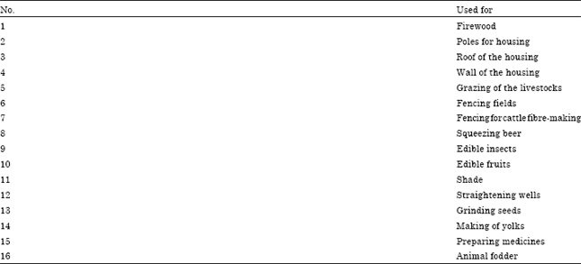 | |
| Source: Field survey, August, 2009 as listed by the local community | |
| Table 2: | Indirect Benefits from forests |
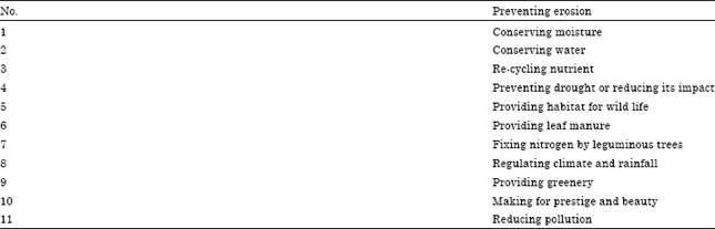 | |
| Source: Field Survey, August, 2009 as discussed and listed by the local community | |
| Table 3: | Sample households in the surveyed villages in tawang district |
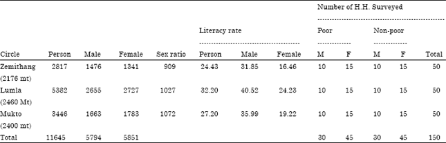 | |
| Note: The village level household data for 2001 is not available. Source: Census data, 2001 and village survey data, August, 2009. H.H: Households, M: Male and F: Female | |
It involves cutting of patches forest in the month of February to March burning of the slashed, dried vegetation after one month and then sowing of crop seeds in April in small holes made throughout slopy fields. Harvesting of the crops is done in succession as they ripe between July to December (Karim and Mansor, 2011). To meet the needs of the growing population, it is necessary to tailor the management options such as shifting sowing window, growing heat tolerant varieties etc. to overcome the ill effects of changing climate arisen due to jhum cultivation (Srivani et al., 2007).The details are in Table 3.
The main tools of the study were two sets of questionnaire namely: (1) household schedule and (2) village schedule. Both household schedule and village schedule were canvassed in the sampled villages. The household schedule seeks to gather information regarding demography as well as socio-economic characteristics of household, occupational pattern and sources of livelihood, land holdings, tenure and production system, collection and use of forest products from community forest, consumption expenditure and household management system etc. In case of stock variables, the position on the day of survey was collected, but in case of flow variables, the information of varying periods was taken into account. The data on production, consumption, income etc. were collected for the year preceding the day of survey. On the other hand, the village schedule also seeks to gather information regarding identification of sampled village, village history, availability of infrastructural facilities, particulars of the quality of forests near the village, role of village institutions and institutional framework of resource management and use. The questionnaires were designed in English for the sake of convenience but were translated into local dialect with the help of interpreters who were part of the survey team at the time of survey wherever necessary. The data collected through the household schedule and village schedule were tabulated in coding sheets to have a clear view of the replies of the respondents and the facts and figures were translated for analytical purposes. Further, the data collected from the field study were also supplemented by the field study notes maintained by the researcher.
Livestock is sometimes regarded as an asset of the rural community. The average value of livestock per household in the study area is round rupees 10, 000 and it is positively related to the consumption value from commons. This may be due to the fact that the value of livestock is likely to be skewed among the rural households in the study area.
Quantify the level of dependence of the community on CPRs: Notwithstanding monitoring and measurement complexities, some of the benefits derived from common property resources in the regions of India have been quantified. Table 2 highlights these benefits. Common property resources have been degraded and their productivity is much lower today than in the past. Consequently, the non-poor i.e., the rural rich (large farmers) depend very little on them. It is not worthwhile for them to collect and use meagre quantities of products from these resources. On the other hand, the rural poor (small farmers and landless labourers) with limited alternatives increasingly depend on low pay-off options offered by such resources. In the villages of the study, 60 to 90% of the rural poor depended on common property resources for fuel, fodder and food; the corresponding proportion of rich farmers did not exceed 20%. The heavy dependence of the rural poor links these resources to the dynamics of poverty and to development interventions centred on the poor. Therefore, any change in the status and productivity of common property resources directly influences the economy of the rural poor. The quantification of dependency of poor and non-poor on CPRs is shown in Table 4.
The average income in percentage form from CPRs in the three circles of the study area is shown in the Fig. 1. The quantification of the dependency of tribal people on CPR can be estab lished in various ways. Most of the researchers are taking into consideration the household income in this aspect. But the collection of quantities information about income from rural areas in the tribal society is extremely difficult and over and under estimation of collected data cannot be ignored.
| Table 4: | Extent of households' dependence on common property resources in the Study area |
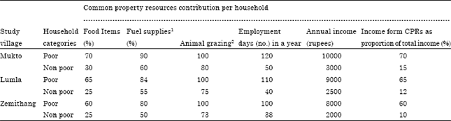 | |
| 1Fuel gathered from common property resources as a proportion of total fuel used during three seasons covering the whole year. 2Animal unit grazing days on common property as a proportion of total animal unit grazing days | |
| Table 5: | CPRs’ contribution to the total consumption expenditure per month in 2009 |
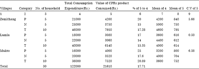 | |
| Source: Field survey, Note: P: Poor, N: Non poor, T: Total household | |
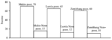 | |
| Fig. 1: | Average income form CPRs in percentage in the study area |
Following the Table 5 regarding poor and non-poor household shows the total consumption expenditure of the household, value of CPR product consumed and then the percentage of CPR product consumed to the total consumption expenditure. It has been observed in the surveyed area that both the poor as well as the non-poor household derive a substantial portion of their consumption requirement from the CPR. The collected basket of CPR products consist of fuel wood, edible leaves, roots, mushroom, fruits from jungles, fish from the river and streams, hunted meat, etc. there is a marginal variation in the consumption of CPR products among the villages.
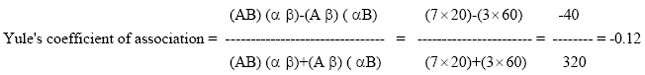
On the average 20, 17 and 20% of the total consumption expenditures of the poor household come from CPRs in Zemithang, Lumla and Mukto respectively while 15, 14 and 20% of total consumption expenditures of the Non poor household come from CPRs in Zemithang, Lumla and Mukto respectively. On an average for three villages, 17.71% of total expenditures depend upon CPRs for the purpose of consumption requirement. If we find the mean value of CPRs Products Consumed for three villages, we get Rs. 795 for Zemithang, Rs. 614 for Lumla and Rs. 752 for Mukto. In case of consumption of items from CPRs, Zemithang is higher than Mukto but Lumla is lowest among them. Again, if we calculate coefficient of variation (C.V.), we get 5.66 for Zemithang, 0.33 for Mukto and 6.38 for Lumla. we see that there is lesser variation in consumption of items from CPRs among the people of Lumla than that of Zemithang and Mukto i.e., more consistency in consumption of items from CPRs among the people of Lumla than that of Zemithang and Mukto as there is lowest value of C.V. for Lumla. The value of C.V. is highest for Mukto meaning that there is less consistency in consumption of items from CPRs among the people of Mukto. From the discussion with the villagers, it was known to the author that the dependency on CPRs is gradually decreasing year by year. As reason they said that the villagers are migrating from village to town for livelihood and education. This is due to the fact that higher level of schooling may have better exit options due to high opportunity cost and hence, forest extraction activities may be less attractive for those households. Besides, availability of government sector jobs may well divert people from dependency on forests. Again we can calculate how much do the unemployed and employed rural people at their own local area depend on CPRs in the study area? In this respect we can apply Yule’s Coefficient of Association following Yule method to see correlation between employed and dependency on CPRs (Table 6).
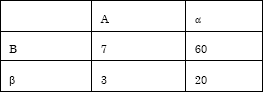
Applying yule’s method for male:
| • | Let A denotes employment. Therefore, á would denote unemployment |
| • | Let B denotes dependency on CPRs above 50%. Therefore, α would denote dependency on CPRs below 50% |
Construction of table for calculation yule’s coefficient of association for male:
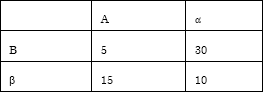 |
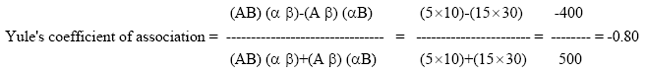 |
Thus, there is high negative association between the dependency on CPRs and employment of male meaning that increase in employment decreases the dependency upon CPRs.
Applying Yule,s method for female:
| • | Let A denotes employment. Therefore, á would denote unemployment |
| • | Let B denotes dependency on CPRs above 50%. Therefore, α would denote dependency on CPRs below 50%. |
Construction of table for calculation Yule’s coefficient of association for female:
 |
 |
Thus, there is low negative association between the dependency on CPRs and employment of female meaning that increase in employment decreases the dependency upon CPRs.
As per discussion of villagers, degradation of common land in 2011 in comparison to 2000 in the three villages is shown in the Table 7 and Fig. 2. We consider here three villages. The decline of common land was due to construction of roads, deployment of armed force to face the Chinese aggression on Tawang. The border in the district is under dispute particularly with Tibet (China) regarding Mac-Mohan Line1 until date. This border dispute led to the Chinese aggression of India in 1962, which was a turning point not only in the history of India but also in the development of the region under study. The result is subject to error and completely based on guess on the basis of discussion with villagers.
Difficulty for estimation: The estimation of income in anywhere of the state is very difficult since the production at the village level is meant mainly for home consumption. On the other hand, the level of monetization is very low. Even after intensive survey, the income data suffers from a lot of errors. This is because the respondents normally hesitate in reporting his/her income. The level of literacy is very low in the study area. It is not possible to get the reliable income data at the household level.
| Table 6: | Percentage of dependency of employed and unemployed male and female on CPRs |
 | |
| Source: Field survey | |
| Table 7: | Extent and decline in area of common property land in the study area |
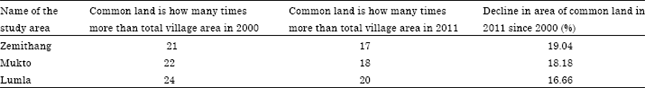 | |
| Source: Field survey | |
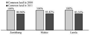 | |
| Fig. 2: | Degradation common land im 2011 in comparison to 2000 |
Hence, we have no other alternative but to take a proxy variable of household level consumption value from the community forest as well as total consumption expenditure of household. For consumption purpose again various edibles, fuel, house building materials etc. gathered from the CPRs are not generally marketed and their valuation is a problem. We have taken their imputed value in estimation of consumption. The data on quantities of different items gathered from forests are dependable but the problem is the non-existence of their village level prices. Some of these forest products are, no doubt, locally bartered but the exchange rate in barter does not reveal the absolute prices which are necessary to arrive at the value. Under these circumstances, we have to take into account of the prices of these products prevailing in the nearest local market.
CONCLUSIONS
The study reveals that CPRs play an important role in the economy of the tribal people of the surveyed villages although the consumption value from community forest is higher for the non-poor households in absolute terms yet in relative terms, the poor households’ dependency on community forest is very important and crucial for their survival. Hence, there is urgent need to form sustainable management of CPRs, particularly the forests in order to avoid ‘the tragedy of commons’. Therefore, there is an urgent need to strengthen the age-old traditional system of village council headed by Gaon Burah in addition to the village Panchayat with specific purpose of management of these resources.
REFERENCES
- Adhikari, B., 2001. Socio-economic heterogeneity and income distribution: Evidence from common property resource management. J. Forestry Livelihoods, 1: 22-24.
Direct Link - Karim, S.M.R. and M. Mansor, 2011. Impact of Jhum cultivation on the Agro-ecology of mountains and Socio-economy of tribal peoples. Asian J. Agric. Res., 5: 109-114.
CrossRefDirect Link - Srivani, O., V. Geethalakshmi, R. Jagannathan, K. Bhuvaneswari and L. Guruswamy, 2007. Impact of future climate change on growth and productivity of rice crop in Tamil Nadu. Asian J. Agric. Res., 1: 119-124.
CrossRefDirect Link