
Mohammd Hezam Al-Mashreki
School of Environmental and Natural Resource Sciences, Faculty of Science and Technology, Universiti Kebangsaan Malaysia, 43600 UKM Bangi Selangor, Malaysia
Juhari Bin Mat Akhir
School of Environmental and Natural Resource Sciences, Faculty of Science and Technology, Universiti Kebangsaan Malaysia, 43600 UKM Bangi Selangor, Malaysia
Sahibin Abd Rahim
School of Environmental and Natural Resource Sciences, Faculty of Science and Technology, Universiti Kebangsaan Malaysia, 43600 UKM Bangi Selangor, Malaysia
Kadderi Md. Desa
School of Environmental and Natural Resource Sciences, Faculty of Science and Technology, Universiti Kebangsaan Malaysia, 43600 UKM Bangi Selangor, Malaysia
Zulfahmi Ali Rahman
School of Environmental and Natural Resource Sciences, Faculty of Science and Technology, Universiti Kebangsaan Malaysia, 43600 UKM Bangi Selangor, Malaysia
Pakistan Journal of Biological Sciences
Year: 2010 | Volume: 13 | Issue: 23 | Page No.: 1116-1128


ABSTRACT
In the present study, an assessment of land suitability potential for agriculture in the study area of IBB governorate, Republic of Yemen has been conducted through close examination of the indicators of land characteristics and qualities. The objective of this study is to evaluate the available land resource and produce the potential map of the study area. Remote sensing data help in mapping land resources, especially in mountainous areas where accessibility is limited. Satellite imagery data used for this study includes data from multi-temporal Landsat TM which dated June 2001. The parameters taken into consideration were 16 thematic maps i.e., slope, DEM, rainfall, soil, land use, land degradation as well as land characteristics maps. Satellite image of the study area has been classified for land use, land degradation and soil maps preparation, while topo sheet and ancillary data have been used for slope and DEM maps and soil properties determination. The land potential of the study area was categorized as very high, high, moderate, low and very low by adopting the logical criteria. These categories were arrived at by integrating the various layers with corresponding weights in a Geographical Information System (GIS). The study demonstrates that the study area can be categorized into spatially distributed agriculture potential zones based on the soil properties, terrain characteristics and analyzing present land use. This approach has the potential as a useful tool for guiding policy decision on sustainable land resource management.
PDF Abstract XML References Citation
Received: July 16, 2010;
Accepted: October 13, 2010;
Published: November 08, 2010
How to cite this article
Mohammd Hezam Al-Mashreki, Juhari Bin Mat Akhir, Sahibin Abd Rahim, Kadderi Md. Desa and Zulfahmi Ali Rahman, 2010. Remote Sensing and GIS Application for Assessment of Land Suitability Potential for Agriculture in the IBB Governorate, the Republic of Yemen. Pakistan Journal of Biological Sciences, 13: 1116-1128.
DOI: 10.3923/pjbs.2010.1116.1128
URL: https://scialert.net/abstract/?doi=pjbs.2010.1116.1128
DOI: 10.3923/pjbs.2010.1116.1128
URL: https://scialert.net/abstract/?doi=pjbs.2010.1116.1128
INTRODUCTION
The use of remote sensing techniques has become increasingly important in describing a variety of satellite-derived data sets and their application to understand changes in the landscape (Kouchoukos et al., 1997). Remote sensing has long been recommended for its potential to detect, map and monitor degradation problems (Hellden and Stern, 1980; Sabins, 1987; Frederiksen, 1993; Mohammed, 1993; Raina et al., 1993; Tripathy et al., 1996; Sujatha et al., 2000) including their spread and effects with time (Sommer et al., 1998). Use of remotely sensed imagery evolved on the basis that traditional survey become expensive and time-consuming. It is especially useful in areas that are not accessible. There are various ways to estimate the extent of land with cultivation potential. Any quantification would depend upon a variety of assumptions. Since land suitability analysis requires the use of different kind of data and information (soil, climate, land use, topography, etc.), the Geographic Information System (GIS) offers a flexible and powerful tool than conventional data processing systems, as it provides a means of taking large volumes of different kinds of data sets and manipulating and combining the data sets into new data sets which can be displayed in the form of thematic maps (Marble et al., 1984; Foote and Lynch, 1996). The topographic characteristics, the climatic conditions and the soil quality of an area are the most important determinant parameters of the land suitability evaluations. Use of GIS allows the construction of models from which a new thematic map (e.g., land suitability map) can be produced from a set of thematic maps (Harasheh, 1994). Other uses of GIS include efficient storage, management and analysis of spatial and non-spatial data (Kapetsky et al., 1987; Rajitha et al., 2007; Giap et al., 2005). In fact, land suitability evaluation is an examination process of the degree of land suitability for a specific utilization type (Sys et al., 1991) and/or description method or estimation of potential land productivity (Rossiter, 1996). Soil maps are the traditional source of information for land suitability analysis (Daigle et al., 2005), but there also a number of difficulties to deal with. The coverage of soil maps, especially those with enough details, is usually limited and the cost of extending this coverage is too high (McKenzie et al., 2000). A study by Drohan et al. (2003) indicated that the purity of mapping units is less than 50%, which may lead to erroneous conclusions when such maps are used to derive suitability maps (Riezebos, 1989; Ziadat et al., 2003). Ziadat (2000) had also previously shown that the accuracy of site-specific suitability using a high detail soil map (1:10,000) was only 60-70%, which is questionable in terms of providing reliable information for land use planning. Soil variability has implications when the soil survey data are used for land evaluation purposes. The soil mapping unit acts as a basic subdivision of land. Thus, the suitability is assigned to the unit by calculating the average and/or modal values of the soil parameters at each of the several observation points (Khalil et al., 1995). Several studies have been undertaken to assess land suitability. Steiner et al. (2000) presented a framework for land suitability analysis based on a thorough ecological inventory of the watershed, so that constraints of and opportunities for land conservation and development could be identified. Land use suitability has been studied from topography, soil, land cover and the interrelationships among landform, soil and vegetation (Allen et al., 1995). However, integration of multiple variables in one assessment cannot produce accurate, efficient results unless a Geographic Information System (GIS) is used. Thus, GIS has found wide applications in land suitability evaluation. With the assistance of a GIS, Liu and Deng (2001) developed a land resources management system to evaluate land suitability. Furthermore, using GIS, Wandahwa and Ranst (1996) implemented land suitability evaluation and mapped climate, altitude, soil type and ecotype. GIS, in combination with the average of individual ratings from a group of experts, was also used to implement a land suitability evaluation model (Kalogirou, 2002; Liu et al., 2003). In addition, GIS functions helped to manage spatial data and to visualize evaluation results (Jingzhong et al., 2003; Wu et al., 2004; Liu et al., 2005). These studies were limited in that the assessment was carried out to identify whether the land was suitable for a particular application. So there were a limited number of physical variables considered. Nevertheless, assessing land potential for all kinds of use has been done very little. Moreover, evaluation concerning land potential has not incorporated current land use practices. Therefore, whether the current land use is optimal remains unknown.
Baja et al. (2007) reported two general kinds of land suitability evaluation approaches: qualitative and quantitative. By qualitative approach (Dent and Young, 1981), it is possible to assess land potential in qualitative terms, such as highly suitable, moderately suitable, or not suitable. In the second approach, quantitative, assessment of land suitability is given by numeric indicators. Al-Areba et al. (2007) evaluated the land suitability for key agricultural crops in Essaouira Province, Morocco. The aim of this evaluation was to find out which parcels of land may best support the different crops commonly grown by the local farmer based on the physical and chemical properties of the soils in the study area and recommend these results to the local stakeholder for an increase in yield. Suitability maps were produced for each specific crop. In general, the evaluation class for the crops suitability ranges from moderately suitable to permanently not suitable. This is due to the different condition that the crops require for their developments in the local area in question. These areas have limitations due to the presence of coarse fragments and rock outcrops, poor drainage, steep slope, high CaCO3 content and texture which are considered to be important factors since they determine the capacity for the penetration of the roots and the capacity to retain water and nutrients. This study was undertaken to develop a new qualitative land suitability method using GIS and remote sensing technologies in arid and semiarid ecosystems such as that of the IBB Governorate, Highland region, Southwestern Yemen. Its aimed to provide a simple example of how RS and GIS technologies can be applied to detect the types of potential land suitability for agriculture of the study area. In addition, to design of an information system for land resource assessment. The study will identify the kinds of data input into a GIS and how this data was used to create useful interpretive maps.
MATERIALS AND METHODS
The study area: IBB Governorate (the study area) is situated in the southern part of the Highland Region of Yemen, between 360,000 m - 460,000 m E and 1,500,000 m -1,600,000 m N (43° 40¯ - 44° 37¯ and 13° 45¯ - 13° 25¯). It is defined as that section of the southern highlands, with a distance of about 200 km from the Sana’a (capital of Yemen). The study area, covering a surface of about 5300 km2, includes 18 districts (Fig. 1) with total population of 2,131,900 inhabitants. The elevation ranging between 600 to more than 3000 m above sea level. It is considered as one of the most important rainfed agriculture in highland region and could be defined as an area that depend mainly on rainfall water and partly on irrigation systems for crop production which was developed centuries ago based on intricate system of man-made terraces.
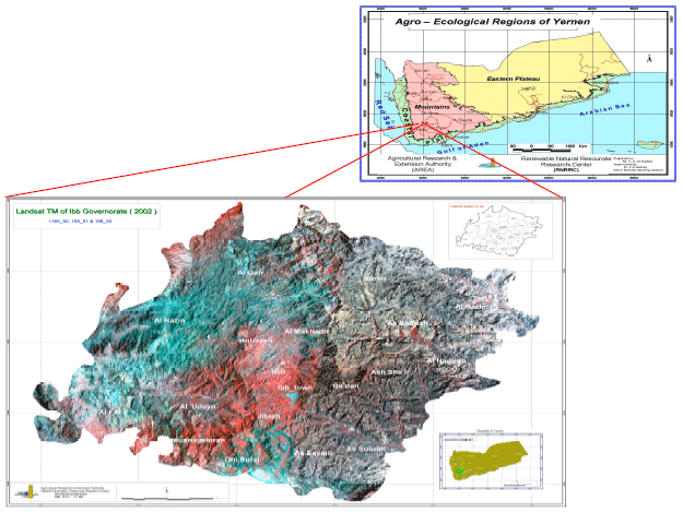 | |
| Fig. 1: | Location diagram of the study area |
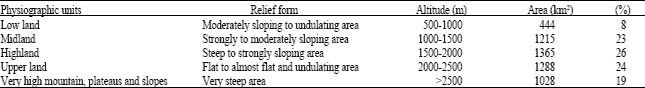
PHYSIOGRAPHY AND RELIEF
The study area is characterized by diverse topography and climatic conditions. The cropping systems are different. It is made up of high mountains over which straddle the terraces and grazing grounds. It has agro-forests, many internal valleys, flood courses and reservoirs in which gathers the rain water coming down from the high slopes. The study area has been divided into five different physiographic units based on relief and topographic variations, which is related to tectonic movements, that dissected the platform, separating geostructural forms, which afterwards due to volcanic and exogenic processes were reshaped into the present landforms. Due consideration was given to slopes, soil parent materials, climatic conditions, vegetation and land use. On the basis of physiographic analysis of the satellite image and topographic data at 100 m contour interval, together with the spot heights, Digital Elevation Model (DEM) was generated.
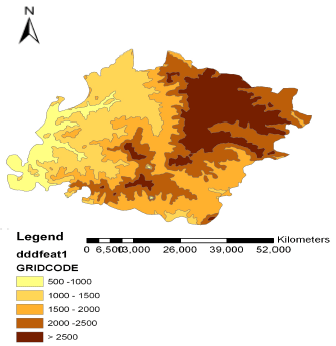 | |
| Fig. 2: | Topographic map of the study area |
Five major physiographic units data were delineated as shown in Table 1 and Fig. 2 and the map produced.
| Table 1: | Physiography and relief form of different physiographic units |
 | |
CLIMATE
Based on the climatic data which were collected from the representative stations i.e., Ibb, Al Udain, Rehab, Yarim/Kitab and Sumarah since 1982 to 2007, the study area is located in semi-arid zone: annual rainfall generally varies between 300 and 900 mm, with some years having exceptionally high rainfall exceeding 1200 mm. Rainfall during summer months have a considerable variation in amount and seasonal distribution from year to year. The average total amount of potential evapotranspiration is estimated at 1450 mm year-1. The mean monthly maximum temperature varies between 23.4°C during the cold months and 28.9°C during the warm month of June. The mean monthly minimum temperature varies between 5.5°C during winter and 12.8°C during the wet month of July. The normal growing period for the study area lasts 170-190 days from April until October with sometimes a relatively dry interval of about two decades during June. The mean daily relative humidity varies between 68 to 76%. The average number of sunshine is 6.3 h day-1 during July-August and 7-9 h day-1 during the other months of the year. Detailed climatic data records available since 1982-2007 from the representative stations is summarized in Fig. 3.
Conceptual framework: Basically the research methodology consists of office study (pre and pro-fieldwork) and actual fieldwork survey for investigation and data collection. The office study involved review of published literature such as books, technical reports and journals. Internet explorer was used to look for relevant data to consolidate land resources theme, besides visiting the concerned institutions and all stakeholders involved with land resources issues. This part also involves analyzing all collected data and information. The fieldwork surveys were carried out to investigate land resources in each topographic unit. Its current situation is then evaluated to formulate the conclusion and recommendation based on the available data collected from the fieldwork and obtained from the interview. For thematic maps production, methodology used in this research consists of: (1) analysis of satellite data (2) use of available GIS programs (3) preparation of thematic maps, (4) generation of land potential map and (e) calculation of area under different mapping units.
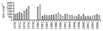 | |
| Fig. 3: | Rainfall amount in the study area during the period 1970-2007 |
The conceptual framework of overall methodology followed is illustrated in Fig. 4.
Research methodology: The main methodology of the research is to prepare thematic maps with the application of remote sensing and GIS software. The actual work involved a comprehensive gathering of information and linked to the related activities. The development and planning of such a vast area for a proposed project requires various data information from the field to identify the terrain characteristics, etc. This is composed of getting use of space images and GIS, complemented with truthing fieldwork as well as making use of the available information from several concerned agencies and sectors in Yemen.
The present study was conducted in an area about 5300 km2, in IBB Governorate, Highland region, Southwest of Yemen during 2008. The study area is located 250 km South the capital city of Yemen. Most of the study area is of Tertiary and recent Quaternary Volcanic origin, through old creataceous, Jurassic and Precambrian Sedimentary and Basic Rocks might outcrops locally. The morphological features of the whole country as well as the study area formed largely as a result of the tectonic and volcanic activities period (Van Der Gun and Ahmed, 1995). The agriculture in the area uses traditional to semi-mechanized techniques and equipment. The power supply is usually tractors. Rainfall water is the main water resource to the region where gravity irrigation is predominant. The following methods and materials were used and followed.
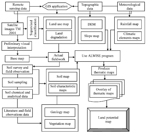 | |
| Fig. 4: | Conceptual framework of the research methodology |
Fieldwork planning phase and preparation (office work): Fieldwork preparation phase includes the following activities; (1) all required base material (topo sheets 1:50,000 scale, satellite images-Landsat TM 2001, 30 m resolution etc.) were collected; (2) available software related to space image processing (e.g., GIS software) were prepared; (3) available previous studies, reports, thematic maps and other parameters were compiled; (4) secondary data and information related to the study area from the concerned agencies were collected; (5) available climatic data from the concerned agencies for meteorological stations within the vicinity of the study area were collected and analyzed in tubular and graphic forms; (6) Digital Elevation Model (DEM) based on topographic data at 100 m contour interval, together with the spot heights were generated; (7) physiographic and administrative maps were produced and their surface area were calculated; (8) the base maps of soil distribution, land use and land degradation based on interpretation and classification of the mentioned satellite images in conjunction with topo sheets were produced. The base map was made as mapping unit of analysis to be used in the field in reference to the USDA survey manual (USDA, 1993). The initial interpretation lines were then prepared for verification in the field; (9) the actual field work plan were prepared.
Field survey and data collection: The semi-detailed soil survey was carried out in the study area. Numerous ground observations were carried out to map the soils, classify, identify their main properties and distribution. In this stage, the survey used soil pits which were normally dig down up to 150 cm depth. Auger observations was also done to determine soil properties and to check the boundary of soil mapping units. Data sheets were used to record the soil information and characteristics. A number of 96 soil profiles and around 40 auger observations were done during this fieldwork. At each soil site, a GPS reading was used to pinpoint the locations. The soil observations were made at regular intervals along east to west and south to north to investigate soils on the different land units. Each soil site and observation includes a description of site (parent materials, landform, land element, topography, vegetation and land use) and information on the soil (texture, drainage, depth, color, surface stones, human interference, etc.). The soil profiles were described according to the FAO guidelines for soil description (FAO, 1976). The soil classified according to the Soil Taxonomy of United States Department of Agriculture (USDA, 2006) and correlated with the World Soil Reference Base (FAO, ISSS, ISRIC, 1998). The soil was classified to the family level. All soil profiles were sampled by horizons for chemical analysis. A total number of 341 soil samples from 96 soil profile were collected. All soils samples were delivered to the laboratory of Renewable Natural Resources Research Center (RNRRC)/AREA for physical and chemical analysis. However, the actual fieldwork were followed of a comprehensive gathering of land resources information and linked to the related activities. Elevation and geographic position were recorded using the Garmin GPS receiver set into WGS 1984 at zone 38 UTM. The slope was measured with the slope meter using a reference object with the same eyesight of the recorder.
Post-fieldwork
Remote sensing and GIS data analysis: The management and analysis of large volumes of spatial data requires computer based systems called Geographical Information System (GIS) which can be used for solving complex geographical and hydrological problems (Garg, 1991). GIS is defined as a system of computer hardware and software designed to allow users to collect, manage, analyze and retrieve large volumes of spatially reference data collected from variety of sources (Aronoff, 1991). Remote sensing data comprises multi-temporal data. Satellite data includes data from Landsat TM dated on June 2001. Three bands were used in the visible spectral range and near infrared such as 2, 3 and 4 with spatial resolution of 30 m. These images were corrected geometrically and analyzed. These analysis were carried out using ERDAS program (imagine 9.1). The space images were checked and found that the four corners of each image were recorded according to the geographic coordinates (long/lat) (WGS84) for the images. All maps were processed to a unified mapping system.
Ancillary data: The ancillary data consists of topographic maps at 1:50,000 scale and geological map at 1:250,000 scale. Various themes (drainage, contour, settlement, roads etc.) have been extracted from topo sheets and incorporated into the GIS environment. Other thematic maps such as soil map, rainfall map and Digital Elevation Model (DEM) were produced to gain data on the general land feature condition of the study area, supplemented with the recent land survey conducted in the area.
Data attribute handling, encoding, digitizing and mapping: All data gathered from the field survey were organized to be analyzed and produced them in tubular and graphic forms. Observation points were downloaded from the GARMIN GPS receiver and imported to ERDAS format to be located in the satellite image of the study area. Supervised classification was done and raster maps of land use type and land degradation were created. These maps were imported to ILWIS format which was then polygonized by on-screen digitization and labeled. Field observations were encoded. For the segment maps and the interpretation lines get north oriented, geocoding by resampling followed with the newly created georeferences using the same coordinate system. Mapping unit symbols were assigned in each polygon based on their relative types. Mapping units and legends were revised, finalized and soil, land use classification and land degradation maps were produced. However, the soil samples were fully analyzed in terms of physical and chemical analysis and the obtained data were reflected to generate thematic maps.
Materials used: The study used a satellite remote sensing Landsat TM, acquired June 2001 with spatial resolution of 30 meters and topo sheets of 1:50,000 scale. The digital data were processed for geometric and radiometric corrections using ERDAS image processing software. Later a standard false color-composite image was generated using Landsat TM band 2.3 and 4 (visible and near infrared images). A number of softwares such as Arc GIS version 9.0, ERDAS Imagine version 9.1, Land and Water Information System (ILWIS) version 3.3, Microsoft office processing tools (Excel, word) and capture software are used in the study. For processing ERDAS was considered useful. The study was applied both visual and digital Landsat image interpretation in order to generate soil, land use and land degradation maps respectively. The field equipments and tools used for fieldwork include soil auger, Garmin 12 XL (GPS) receiver, slope meter, digital camera, Munsell color chart (USDA, 1994), soil knife, hammer, shovel, 30 m measuring tape and pH and EC kits.
RESULTS AND DISCUSSION
Potential of remote sensing and GIS for land potential for agriculture: Classification of land suitability for sustainable use requires an understanding of conditions and processes controlling land characteristics and qualities in the study area. The main factors which could influence land suitability evaluation for the study area have been defined and analyzed and thematic maps have been produced to be overly such as Digital Elevation Model (DEM), slope, rainfall distribution, soil, land degradation, land use and land characteristics maps (pH, calcium carbonate, electric conductivity, available phosphorus, organic matter, cation exchange capacity, soil texture, soil depth, surface stones). All these thematic maps were produced in digital format as database of land resources characterization of the study area and ranked. Each of these maps as factors is described in more detailed for a better understanding of their contribution in assessment of land suitability potential for agriculture in the study area.
Twenty three soil mapping units were derived from the semi-detailed soil study of the area and legend was revised, finalized. (Table 2) and soil classification map generated on 1:50,000 scale by using ArcGIS program. (Fig. 5).
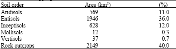
The soil map (Fig. 5) indicate that five international soil orders have been recognized in the study area i.e. Aridisols, Entisols, Inceptisols, Mollisols and Vertisols (Table 2) which include 23 soil great groups as well as rock outcrops. They are occupies 11, 36, 12, 0.3, 0.7%, respectively and 40% for rock outcrops based on the calculation process of the surface area for each mapping unit through ArcGIS and ILWIS softwares. The main properties used to differentiate soils are texture and degree of stratification, depth, drainage, the presence of calcic horizon, salinity and/or alkalinity and the presence of a surface organic horizon. Subsidiary properties are cracking and slickenside development and takyric features at the surface. The soil survey provides the foundation layer for geographic information systems used for land use planning and good land management. It describes the characteristics, limitations and best potential uses for the different soil types found in the study area.
The most useful application of GIS in resource investigation is to overlay various thematic maps such as soils, land use, land degradation, DEM, slope and land characteristics and land qualities etc. to derive useful results. GIS then is a powerful tool for management and analysis of data required for any land developmental activity. The present study has utilized the analytical capabilities of GIS in generating of thematic maps on land productivity. The area under each productivity class for field crops, forage crops and tree crops will be also arrived. Assessment of environmental situation and hazard and the vulnerability of the population are particularly important for effective mitigation efforts.
In this study, in addition to existing data and fieldwork, spatial and temporal remote sensing data have been extensively used and analyzed under a GIS environment. Implementation of GIS application development with the remote sensing data (satellite imagery) laying of topo sheet survey data from topo maps (1:50,000 scales) available from Survey Authority of Yemen and digitization of different maps was helped to complete the work in much easier way.
| Table 2: | Soil mapping units combined under soil order |
 | |
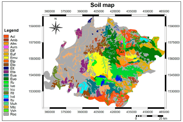 | |
| Fig. 5: | The soil map of the study area |
Weighted overlay and model building: Overlay operation is part of spatial analysis processes based on the value of weightage of each subclass within each thematic map. A weighted overlay was used to combine all factor layers maps into new information to produce individual value for each pixel and new map was produced. The weightage values used in the overlay operations are only performed on raster maps. The weightages were given based on the influence of every subclass. It should be noted that the heuristic value for factor and classification is given between 1 to 5 in this study, where value of 1 show the influence or result towards very low while value 5 is very high. The concept of overlay model, which contains major steps of the weightage are schematically shown in Fig. 6 and 7.
The preparation of input layers was greatly facilitated by the Geo-Referenced Interface Package for ILWIS v.3.4. This is a stand-alone windows program that relies on the ILWIS 3 GIS to automatically extract digital terrain and land surface layers from GIS vector data, at a user defined grid cell size and format the output as ILWIS raster maps for visualization and further analysis. Accordingly the criterion and sources used is presented to establish the initial parameterization as input maps and single values, respectively. We called this our best guess as we tried to get as close as possible to reality according to the available data and our experience, i.e., before any model calibration. This relies crucially on field experience with soil-water-land use relations in the region where the model is to be applied. The highest and lowest realistic parameter limits for map inputs changing according to possible variability in the study area (e.g., soil group, hydrologic conditions, organic matter contents, textural classes and management practices). We called these our optimistic and pessimistic realistic scenarios.
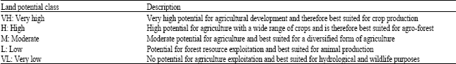
Land potential map: Soil properties and land use capability analysis provide a method of determining the potential and/or management requirements of the land based upon an assessment of its characteristics. The principle data sets required when determining land potentiality are; slope, topography, current land use, soils and soil properties, soil erosion hazards, drainage and flooding characteristics (Jammy and Carsten, 2000). For the study area, a five classes of land potential map have been given at scale of 1:50 000, but instead of considering only agricultural factors, other resources groups such as forestry, rangeland and hydrology are also incorporated (Table 3).
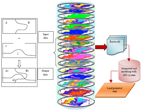 | |
| Fig. 6: | Concept of the model |
 | |
| Fig. 7: | The overlay model |
It should be noted that Land potential classes are ordered to recognize increasing degrees of limitations or hazards associated with use and a decreasing degree of versatility of use. Land within a particular class can be used for purposes compatible with the lower potential classes but should not be used beyond its capability. In this study all thematic maps already mentioned have been combined through an index overlay with multi-class maps and summing of each pixel values, to produce the land potential map at 1: 50.000 scale to show the potential of the area to agricultural production based on the influence of relative factors and their weightages (Fig. 8). The range of the potential values in figure 7 are reclassified into five different classes as already mentioned in Table 3, further, land potential zonation map in the same scale shown in Fig. 9.
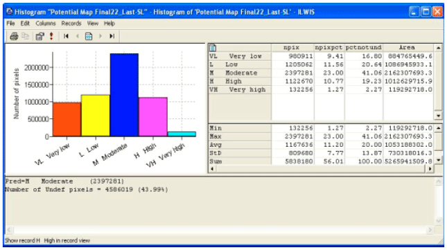
From the land potential zonation map, it can be concluded that the very low potential land occupies 17% (885 Km2), low potential land occupies 21% (1087 km2), moderate potential land occupies 41% (2162 km2), high potential land occupies 19% (1013 km2) and very high potential land occupies 2% (119 km2) (Fig. 10).
By analyzing the land potential zonation map (Fig. 9), t is evident that the very high potential land can be observed just in limited area due to deep soil, good drainage, texture, proper slope and very high rainfall amount of the area. The high potential land is located in some part of the study area due to well soil properties and high rainfall amount, but slope influence the suitability of the area. As seen from the map, the largest part of cultivated area was evaluated as moderate potential land due to factors influence the suitability such as drainage, depth, texture and moderate rainfall amount. The others factor such as slope never influence the suitability of the area. the very low and low potential land can be observed only in the northwest, southwest and some parts at the southeast because of the physical limitations such as sandy soil texture and limited soil depth, low and very low rainfall and slope and land degradation. For almost the entire study area soil salinity and CaCO3 were never considered as limiting factors.
Generally, the most important limiting factors in field crops production in the study area included physical properties of the soil especially soil depth, texture and drainage and the amount of rainfall. Yasmina et al. (2001) also suggested that the most limiting factors of the land suitability in the Province of Ben Slimane, Morocco, in wheat and barley productions included physical characteristics such as soil texture, soil depth and drainage.
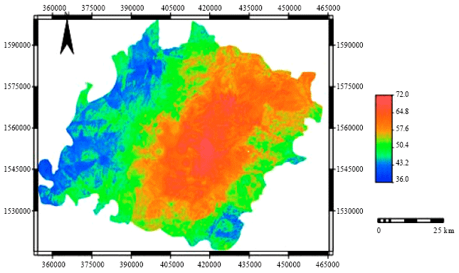 | |
| Fig. 8: | Land potential map of the study area |
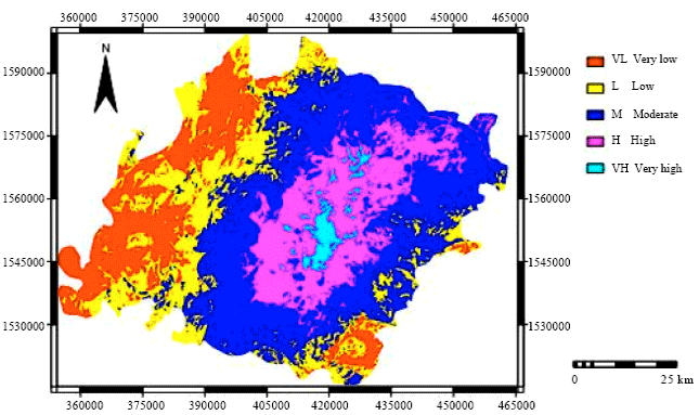 | |
| Fig. 9: | Land potential zonation map of the study area |
| Table 3: | The classification of potential land |
 | |
 | |
| Fig. 10: | Histogram of land potential zonation map of the study area |
CONCLUSIONS
Implementation of GIS application development with the remote sensing data (satellite imagery) laying of topo sheet data (1:50,000 scales) and digitization of different maps help to accomplish the work in much easier way. It is concluded that the study area has a variety of constraints associated with available land resources which are listed as: semi-arid climate, low, erratic, ill-distributed rainfall and accelerated soil erosion by runoff water. Research results on land resources management in general and on methodology for thematic maps compilation in particular will serve as scientific basis to workout agricultural development strategy in different stages of national economy development. It will also serve as scientific basis for economy planning, appropriate land use planning at increasing economy efficiency of agro-forestry production and recommending measures to improve actual land capability to ensure a sustainable land resources development. It could be concluded that the information provided by this study will be useful in the planning of development activities in Yemen. It will assist in locating areas of high potential where more derailed soil/land information would facilitate the introduction of new technology for agricultural production.
ACKNOWLEDGMENTS
I would like to thank the Government of Yemen for all supports given to me. I would like to express my sincere appreciation and gratefulness to UKM particularly School of Environmental and Natural Resources Science and Geology Program for supporting this research.
REFERENCES
- Adel, A.A., A.S.A. Salami, A. Ouafae, B. Rigobert, D. Laura and G. Gebremeskel et al., 2007. Land evaluation in essaouira province Morocco. Proceedings of the 27th Professional Course on Geomatics and Natural Resources Evaluation, November 6, 2006-June 22, 2007, Foreign Affairs, Istituto Agronomico Per L'oltremare, pp: 1-213.
Direct Link - Allen, R.B., A.E. Hewitt and T.R. Partridge, 1995. Predicting land use suitability from vegetation and landform in depleted semiarid grassland, New Zealand. Landscape Urban Plann., 32: 31-42.
CrossRefDirect Link - Baja, S., D.M. Chapman and D. Dragovich, 2007. Spatial based compromise programming for multiple criteria decision making in land use planning. Environ. Model. Assess., 12: 171-184.
CrossRefDirect Link - Daigle, J.J., W.H. Hudnall, W.J. Gabriel, E. Mersiovsky and R.D. Nielson, 2005. The National Soil Information System (NASIS): Designing soil interpretation classes for military land-use predictions. J. Terramechanics, 42: 305-320.
CrossRef - Drohan, P.J., E.J. Ciolkosz and G.W. Petersen, 2003. Soil survey mapping unit accuracy in forested field plots in Northern Pennsylvania. Soil Sci. Soc. Am. J., 67: 208-214.
Direct Link - Giap, D.H., Y. Yi and A. Yakupitiyage, 2005. GIS for land evaluation for shrimp farming in Haiphong of Vietnam. Ocean Coastal Manage., 48: 51-63.
CrossRef - Hellden, U. and M. Stern, 1980. Monitoring land degradation in southern Tunisia: A test of LandSAT imagery and digital data. LAFHI RSL Res. Rep., 48: 42-42.
Direct Link - Kalogirou, S., 2002. Expert systems and GIS: An application of land suitability evaluation. Comput. Environ. Urban Syst., 26: 89-112.
Direct Link - Kouchoukos, N., R. Smith, A. Gleason, P. Thenkabail and F. Hole et al., 1997. Monitoring the distribution, use, and regeneration of natural resources in semi-arid Southwest Asia. Proceedings of the Transformations of Middle Eastern Natural Environments: Legacies and Lessons, Oct. 28-Nov. 1, Yale University, pp: 467-491.
Direct Link - Liu, Y.S. and X.Z. Deng, 2001. Structural patterns of land types and optimal allocation of land use in Qinling Mountainous. J. Geographical Sci., 11: 99-109.
CrossRef - Liu, Y., J. Gao and Y.F. Yang, 2003. A holistic approach towards assessment of severity of land degradation along the Great Wall in Northern Shaanxi Province, China. Environ. Monitoring Assess., 82: 187-202.
CrossRef - Raina, P., D.C. Joshi and A.S. Kolarkar, 1993. Mapping of soil degradation by using remote sensing on alluvial plain, Rajathan, India. Arid Soil Res. Rehabilitation, 7: 145-161.
CrossRef - Rajitha, K., C.K. Mukherjee and R.V. Chandran, 2007. Applications of remote sensing and GIS for sustainable management of shrimp culture in India. Aquacult. Eng., 36: 1-17.
CrossRef - Riezebos, H.T., 1989. Application of nested analysis of variance in mapping procedure for land evaluation. Soil Use Manage., 5: 25-29.
Direct Link - Rossiter, D.G., 1996. A theoretical framework for land evaluation. Geoderma, 72: 165-202.
Direct Link - Sommer, S., J. Hill and J. Megier, 1998. The potential of remote sensing for monitoring rural land use changes and their effects on soil conditions. Agric. Ecosyst. Environ., 67: 197-209.
CrossRef - Steiner, F., L. McSherry and J. Cohen, 2000. Land suitability analysis for the upper Gila River watershed. Landscape Urban Planning, 50: 199-214.
CrossRef - Sujatha, G., R.S. Dwivedi, K. Sreenivas and L. Venkataratnam, 2000. Mapping and monitoring of degradaded lands in part of Jaunpur district in Uttar Pradesh using temporal spaceborne multispectral data. Int. J. Remort Sens., 21: 519-531.
CrossRef - Tripathy, G.K., T.K. Gohosh and S.D. Shah, 1996. Monitoring of desertification process in Karnataka state of India using multi-temporal remote sensing and ancillary information using GIS. Int. J. Remote Sensing, 17: 2243-2257.
CrossRef - Wandahwa, P. and E.V. Ranst, 1996. Qualitative land suitability assessment for pyrethrum cultivation in west Kenya based upon computer-captured expert knowledge and GIs. Agric. Ecosyst. Environ., 56: 187-202.
CrossRef - Van Der Gun, J.A.M. and A.A. Ahmed, 1995. The water resources of Yemen. A summary and digest of available information. Report WRAY-35. Water Resources Assessment Yemen. Ministry of Oil and Mineral Resources, General Department of Hydrology, Sana’ Yemen. TNO Institute of Applied Geoscience, The Netherlands.
- Ziadat, F.M., J.C. Taylor and T.R. Brewer, 2003. Merging landsat TM imagery with topographic data to aid soil mapping in the Badia region of Jordan. J. Arid Environ., 54: 527-541.
CrossRef
ogunyemi Reply
sir, you did a very good job in carry out this work, can i share more knowledge in getting more information, on how to apply remote sensing in crop monitoring.My background is computer science