
Mostafa Emadi
Department of Soil Science, Shiraz University, Shiraz, Iran
Majid Baghernejad
Department of Soil Science, Shiraz University, Shiraz, Iran
Mehdi Emadi
Department of Geology, Shiraz University, Shiraz, Iran
Manouchehr Maftoun
Department of Soil Science, Shiraz University, Shiraz, Iran
Pakistan Journal of Biological Sciences
Year: 2008 | Volume: 11 | Issue: 2 | Page No.: 238-243


ABSTRACT
Spatial patterns for several soil parameters such soil texture, Exchangeable Sodium Percentage (ESP), Electrical Conductivity (ECe), soil pH, Cation Exchange Capacity (CEC) were examined in saline and sodic soils in Arsanjan plain, Southern Iran, in order to identify their spatial distribution for implementation of a site-specific management. Soil samples were collected from 0-30, 30-60 and 60-90 cm soil depths at 85 sampling sites. Data were analyzed both statistically and geostatistically on the basis of the semivariogram. The spatial distribution model and spatial dependence level varied between soil parameters. Soil pH and ESP had the minimum and maximum variability at all depths, respectively. Soil properties indicated moderate to strong spatial dependence. ECe exhibited moderate spatial dependence at three depths; pH and ESP had a moderate spatial dependence at 0-30 cm and strong spatial dependence at 30-60 and 60-90 cm depths. Clay and CEC exhibited strong spatial dependence for the 0-30 cm and weak spatial dependence at 30-60 and 60-90 cm depths. Sand and silt had a non-spatial dependence at 0-30 cm and weak spatial dependency at 30-60 and 60-90 cm depths. The spatial variability in small distances of ECe, CEC, pH and ESP generally increased with depth. All geostatistical range values were greater than 1168 m. The results reported herein indicated that the strong spatial dependency of soil properties would lead to the extrinsic factors such as ground water level and drainage. It is important to know the spatial dependence of soil parameters, as management parameters with strong spatial dependence will be more readily managed and an accurate site-specific scheme for precision farming more easily developed.
PDF Abstract XML References Citation
How to cite this article
Mostafa Emadi, Majid Baghernejad, Mehdi Emadi and Manouchehr Maftoun, 2008. Assessment of Some Soil Properties by Spatial Variability in Saline and Sodic Soils in Arsanjan Plain, Southern Iran. Pakistan Journal of Biological Sciences, 11: 238-243.
DOI: 10.3923/pjbs.2008.238.243
URL: https://scialert.net/abstract/?doi=pjbs.2008.238.243
DOI: 10.3923/pjbs.2008.238.243
URL: https://scialert.net/abstract/?doi=pjbs.2008.238.243
INTRODUCTION
Precision agriculture uses principles of farming according to the field variability, which requires new requirements for estimating and mapping spatial variability of soil properties. In the last decades, important contributions has been made by geostatistics to understand soil distribution patterns within the landscape, which are required for effective land management. Samples close to each other have more similar properties than those located far from each other. However, the classical statistic, assuming the measured data independent, is not capable to analyze the spatial dependency of the variable (Cemek et al., 2007). The interpolation techniques commonly used in agriculture include Inverse Distance Weighting (IDW) and kriging (Kravchenko and Bullock, 1999; Ardahanlioglu et al., 2003). Both methods estimate values at unsampled location based on the measurements from the surrounding locations with certain weights assigned to each measurement. IDW is easier to implement, while kriging is more time-consuming and cumbersome. However, kriging provides a more accurate description of the data spatial structure and produces valuable information about estimation error distribution (Kravchenko and Bullock, 1999). Surface soil properties (Brejda et al., 2000), soil nutrient content (Newman et al., 1997), soil chemical properties (Lee et al., 2001; Ardahanlioglu et al., 2003), nitrate leaching (Ersahin, 2001) and distribution of soil physical characteristics in soils (Sepaskhah et al., 2005) could be analyzed with geostatistical methods to predict spatial variation in soil properties.
Although these studies provided very precise information for site-specific recommendations, such information for soils of Arsanjan plain with semiarid condition is lacking and thus, need to be assessed. Moreover, it is important to consider the fact that spatial variability of soils depends on the specific soil studied. The Arsanjan plain is one of the most important agricultural production areas of Fars province (Southern Iran). Crop productivity is threatened in this region due to the lack of an outlet for drainage water, high groundwater level and low quality of water using as irrigation water. Therefore, the assessment of salinity, sodicity and other important soil characteristics in this plain is needed to establish data of salt and sodic affected soils and to evaluate their spatial variability for site-specific management. The aims of this study were to (1) examine spatial variability in Exchangeable Sodium Percentage (ESP), Electrical Conductivity (ECe), soil pH, particle size distribution, Cation Exchange Capacity (CEC) and (2) assess spatial distribution patterns of saline and sodic soils in Arsanjan plain.
MATERIALS AND METHODS
Description of the study area: This study was conducted within Arsanjan plain that was located in Fras province, southern Iran (29° 43` to 29° 47` N latitude and 53° 09` to 53° 16` E longitude). The mean annual precipitation, evaporation and temperature are 323.8 mm, 989.1 mm and 18.2°C, respectively. Soil moisture and temperature regime are xeric and thermic, respectively. The prominent soils of Arsanjan plain are somewhat affected with salinity and/or sodicity because of high evaporation. Extensive areas of the Arsanjan plain have become and continue to be degraded by salinization due to the use of low-quality irrigation water with inappropriate irrigation methods. As a result, agricultural production of the Arsanjan plain has declined significantly in the last two decades.
Soil sampling and laboratory analysis: Soil samples in September 2006, in the 85 sampling site (10187 ha) were collected from 0-30, 30-60 and 60-90 cm depths, georefrenced using GPS receiver (accuracy of ±5 m), analyzed for ESP, ECe, pH, CEC and particle size distribution. ESP was determined using the ammonium acetate (NH4OAc) method (Thomas, 1982); soil pH was measured with a glass electrode pH meter (McLean, 1982). Soluble salts were calculated by measurement of ECe in the soil extraction by the use of a conductivity meter (Rhoades, 1982). CEC was determined using the sodium saturation method (Rhoades, 1986). Particle size distribution was determined by hydrometer method (Gee and Bauder, 1986).
Statistical analysis and interpolation: The data analyses were conducted in three stages: (a) normality tests were applied (Kolmogrov-Smirnov); (b) distribution was analyzed by classical statistics (mean, maximum, minimum, standard deviation, skewness and coefficient of variations); (c) geostatistical parameters were calculated for each variable as a result of corresponding semivariogram analysis. Skewness is the most common form of departure from normality. If a variable has positive skewness, the confidence limits on the variogram are wider than they would otherwise be and consequently, the variances are less reliable. A logarithmic transformation is considered where the coefficient of skewness is greater than 1 and a square-root transformation applied if it is between 0.5 and 1 (Webster and Oliver, 2001). Exploratory statistical analyses were performed by SPSS (1997) software. A semivariogram was calculated for each soil property as follows (Isaaks and Srivastava, 1989; Journel and Huijbregts, 1978):
| Where: |
| γ(h) | = | Experimental semivariogram value at distance interval h |
| N(h) | = | Number of sample value pairs within the distance interval h |
| z(xi), z(xi+h) | = | Sample values at two points separated by the distance interval h |
All pairs of points separated by distance h (lag h) were used to calculate the experimental semivariogram. Semivariograms were calculated both isotropically and anisotropically. Spherical, exponential or pure nugget models were fitted to the empirical semivariograms. Model selection for semivariograms was done on the basis of regression (r2), visual fitting and Residual Sum of Squares (RSS). To define different classes of spatial dependence for the soil variables, the ratio between the nugget semivariance and the total semivariance or sill was used (Cambardella et al., 1994). Geostatistical software (GS+5.1, 2001; Gamma Design Software) was used to conduct semivariogram and special structure analysis for soil variables.
RESULTS AND DISCUSSION
A histogram, box plot and normal plot were constructed for all soil properties, revealing three and two outliers for pH at 0-30 and 60-90 cm depths, respectively. Their removal significantly reduced the coefficient of skewness (lower than 0.4) avoiding the need for data transformation. Two (21.2, 19.2) and one (0.2) potential outliers with ECe at depth of 0-30 and 30-60 cm, respectively, found from exploratory analysis for electrical conductivity. The bulk of the data has an ECe of approximately 5 dS m-1, which dramatically affects the normality of the distribution. However, these outliers data
 |  | |
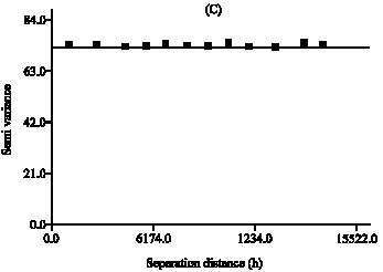 | 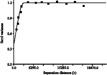 | |
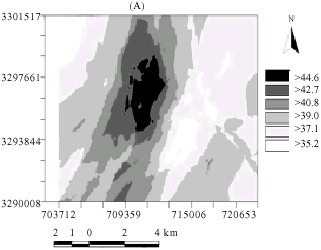
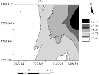
| Fig. 1: | (A, B) maps of estimated silt (%) and ECe (dS m-1) in 0-30 cm depth, respectively and (C, D) experimental and modeled semivariograms for silt (%) and ECe (dS m-1) in 0-30 cm depth, respectively |
Table 1: | Descriptive statistics for studied soil properties |
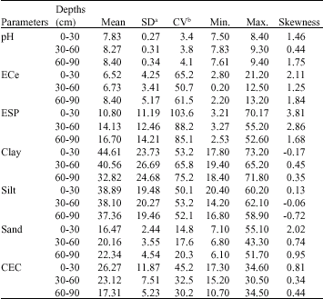 | |
| a: Standard deviation; b: Coefficient of variation | |
are of most interest to the analysis of salinity and hence, they are kept in the dataset. Furthermore, since the coefficients of skewness in some soil properties (ECe and ESP at three depths and sand at 0-30 cm) are greater than 1 (Table 1), the natural logarithm is applied for a kriging analysis to stabilize the variance (Goovaerts, 1997). Applying ordinary kriging to logarithmic transformed data is the essence of lognormal kriging. Explanatory analysis for CEC revealed two potential outliers (34.6 and 31.2), however, visualization showed that this value is located on the periphery of the study area and therefore it will not be included in many lags. It also has relatively large values contiguous to it. Consequently, the decision was to include the data in the analysis. Although the coefficient of skewness for CEC at 0-30 cm is located in the range where a square-root transformation is appropriate, it is that outlying value on the periphery that is skewing the data, so the data were left in its original
| Table 2: | Semivariogram models and models parameters for studied soil properties |
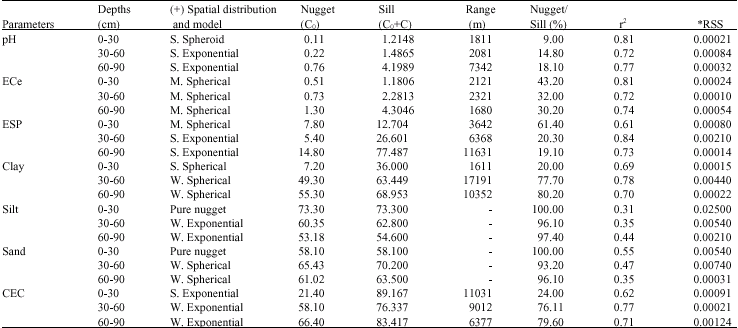 | |
(+): Spatial distribution (S-strong spatial dependence (<25%); M-Moderate spatial dependence (26-75%); W-weak spatial dependence (>75%); Pure Nugget- no spatial correlation (100%) and their spatial distribution model *: Residual sum of squares (often the model with the lowest RSS chooses as optimal) | |
form. The exploratory analysis and descriptive statistics of the other soil parameters at each depth suggested that they were all normally distributed and therefore no transformation was needed for geostatistical analysis.
The coefficient of variations (CV) of soil properties except pH was fairly high, indicating that soil properties were generally heterogeneous (Table 1). The highest CV value was for ESP, while the CV values for pH was the lowest in all the three depths. In general, the CV for other soil characteristics, except ECe, decreased with soil depth. However, the mean values of pH, ECe and ESP increased, whereas the mean values of CEC decreased with soil depth due to the fact that, clay content decreased with soil depth. Application of poor quality water would result in increase in pH, ECe and ESP. A highly significant positive correlation was observed between soil salinity and water content in Entisols, with high clay content and low infiltration capacity (Miyamoto and Chacon, 2005). Another reason for higher values of these soil properties in the lower layers was due to the decrease in clay content with depth (Table 1). Kachanoski et al. (1988) found that ECe was affected by volumetric water content and increased with increasing water content when clay content was low.
Anisotropic semivariograms did not show any differences in spatial dependence based on direction and therefore isotropic semivariograms were chosen. The geostatistical analysis indicated different spatial distribution models and spatial dependence levels for the soil parameters. Exponential, spherical and pure nugget models were used to define soil properties (Table 2). Nugget effect was higher for CEC, clay, silt, sand and ESP compared to pH and ECe. This indicated that these soil properties had spatial variability in small distances. The nugget effect of ECe, pH, clay and ESP were generally increased with depth. The large nugget semivariance and the non-spatial dependence for silt and sand (Fig. 1A, B for silt at 0-30 cm, slope of semivariogram was close to zero, 100%, nugget semivariance/sill ratio) suggest that an additional sampling of these variables at smaller lag distances and in larger numbers is needed to detect spatial dependence. However, under no research circumstances (which means in a commercial context) a larger sampling density is usually not feasible. The recent research showed that using geostatistical and remote sensing approaches for mapping soil surface characteristics could improve the prediction quality (Lopez-Granados et al., 2005).
When the distribution of soil properties is strongly or moderately spatially correlated (for example for EC at 0-30 cm depth, indicated in Fig. 2C, D), the mean extent of these patches is given by the range of the semivariogram. A larger range indicates that observed values of the soil variable are influenced by other values of this variable over greater distances than soil variables which have smaller ranges (Samper-Calvete and Carrera-Ramirez, 1996). Range value varied from 1168 m (Ece in the 30-60 cm depth) to 17191 m (clay at 60-90 cm depth). Thus, clay had a range of more than 17000 m at 30-60 cm depth. This indicates that clay contents influenced the neighboring values of clay over greater distances than other soil variable e.g., ECe, which had a range of less than 1200 m at 0-30 cm depth.
Generally, range values of ECe and pH were smaller than that of the other soil properties. Soil properties exhibited both a consistent and non-consistent spatial pattern regarding the sampling depth at three locations. Some soil properties such as ESP, clay and CEC following a different spatial distribution at each depth, showed a moderate spatial dependence in 0-30 cm depth and a strong spatial dependence in other tow depths (Table 2). Similarity, ECe and pH showed a similar trend at three sampling depths and followed the same spatial pattern. Cambardella and Kallen (1999) reported a similar consistent and non-consistent spatial distribution according to the sampling depths e.g., NH4-N showed three spatial patterns: Moderate spatial dependence at 0-10 cm depth, no spatial dependence at 10-20 cm depth and strong spatial dependence 20-30 cm depth, while pH exhibited a strong spatial dependence at all depths.
The low nugget variance/total variance ratio and small range values for some soil properties exhibited patchy distribution pattern. The patchy distribution can be related to the groundwater level and topography. This study emphasizes that even though the previous agricultural management was similar, the spatial distribution and spatial dependence level of soil properties can be different. These results confirm the importance of collecting information in every agricultural region to select the proper a site specific system. Long-term field management histories should be known, since even the same farming practices, clearly effectively affects both spatial distribution and the level of spatial dependence. Strong spatial dependency of soil variables may be controlled by intrinsic variations in soil characteristics (Cambardella et al., 1994). The results presented here suggested that extrinsic factors such as ground water level, drainage and irrigation systems would be important factors affecting in strong spatial dependency of soil properties. Soil salinity (ECe) and sodicity (ESP) had generally high values in the northeast side of the study area. Values for ESP and ECe ranged between high and very high in the Northeast side, suggesting that proper soil management and drainage techniques are needed to decrease soil salinity and sodicity in these regions. Jackknifing analysis was used to test if the chosen semivariogram models accurately predicted soil properties at unsampled locations. The results indicated that the mean reduced error was near zero and the squared differences between the jackknifed and the original values were lowest for the fitted models. This means that the kriging estimates are accurate and the spatial relationships derived from the studied part of the research site may be applicable to other areas with similar characteristics in the Arsanjan plain.
CONCLUSIONS
In general, most of the studied soil properties indicated strong spatial dependency in 0-30 cm depth, while they exhibited moderate spatial dependency in the 30-60 and 60-90 cm depths. Geostatistical range values for most soil properties, were greater than 1200 m, indicating that soil-sampling distance for further sampling designs should be taken as 1200 m. The nugget effect of ECe, CEC, pH, clay and ESP were generally higher in 0-30 cm than in 30-60 and 60-90 cm depths. The majority of soil properties showed a strong spatial dependency at small distances in the topsoils. This could be attributed to different in the fluctuation and drainage of the groundwater in the Arsanjan plain and other places in arid and semiarid areas with similar conditions. The results emphasized that irrigation was created salinity and sodicity problem in the study area and probably low quality of irrigation water; extreme water use and insufficient drainage are mainly responsible for such condition. Besides, this study suggested that distribution maps of these soil properties may be used to develop indicator maps, which can separate areas within the Arsanjan plain, according to their management and reclamation requirements. Recently, the amount of irrigation water was decreased in order to lower the adverse effects of irrigation water on soil properties. In the study area, furrow irrigation is in progress. Sprinkle or subsurface irrigation methods is recommended instead of furrow irrigation to decrease the amount of irrigation water used. Also, local areas with high salinity and sodicity or having salinity and sodicity risk should be continuously monitored for depth of groundwater table and groundwater salinity to avoid upward transport of soluble salts with evaporation during irrigation season.
REFERENCES
- Ardahanlioglu, I., T. Oztas, S. Evren, T. Yilmaz and Z.N. Yildirim, 2003. Spatial variability of exchangeable sodium, electrical conductivity, soil pH and boron content in salt and sodium-affected areas of the Igdir plain (Turkey). J. Arid. Environ., 54: 495-503.
CrossRef - Brejda, J.J., T.B. Moorman, J.L. Smith, D.L. Karlen, D.L. Allan and T.H. Dao, 2000. Distribution and variability of surface soil properties at a regional scale. Soil Sci. Soc. Am. J., 64: 974-982.
CrossRefDirect Link - Cambardella, C.A., T.B. Moorman, J.M. Novak, T.B. Parkin, D.L. Karlen, R.F. Turco and A.E. Konopka, 1994. Field-scale variability of soil properties in central Iowa soils. Soil Sci. Soc. Am. J., 58: 1501-1511.
CrossRefDirect Link - Cambardella, C.A. and D.L. Kalen, 1999. Spatial analysis of soil fertility parameters. Precision Agric., 1: 5-14.
CrossRefDirect Link - Cemek, B., M. Guler, K. Kilic, Y. Demur and H. Arslan, 2007. Assessment of spatial variability in some soil properties as related to soil salinity and alkalinity in Bafra plain in Northern Turkey. Environ. Monit. Assess., 124: 223-234.
CrossRefDirect Link - Ersahin, S., 2001. Spatial variability of some physical and chemical soil properties in an alluvial field. Applied Eng. Agric., 13: 34-41.
Direct Link - Kachanoski, R.G., E.G. Gregorich and I.J. Van Wesenbeck, 1988. Estimating spatial variations of soil water content using noncontaining electromagnetic inductive methods. Can. J. Soil Sci., 68: 715-722.
Direct Link - Keranchenko, A.N. and D.G. Bullock, 1999. A comparative study of interpolation methods for mapping soil properties. Agron. J., 91: 393-400.
Direct Link - Lee, B.D., R.C. Graham, T.E. Laurent, C. Amrhein and R.M. Creasy, 2001. Spatial distributions of soil chemical conditions in a serpentinitic wetland and surrounding landscape. Soil Sci. Soc. Am. J., 65: 1183-1196.
Direct Link - Lopez-Granados, F., M. Jurado-Expósito, J.M. Pena-Barragan and L. Garc2a-Torres, 2005. Using geostatistical and remote sensing approaches for mapping soil properties. Eur. J. Agron., 23: 279-289.
Direct Link - McLean, E.O., 1982. Soil pH and Lime Requirement. In: Methods of Soil Analysis, Part 2: Chemical and Microbiological Properties, Page, A.L., R.H. Miller and D.R. Keeney (Eds.). 2nd Edn., ASA and SSSA, New York, USA., pp: 199-224.
Direct Link - Miyamoto, S. and A. Chacon, 2005. Soil salinity of urban turf areas irrigated with saline water: II. Soil factors. Landscape Urban Planning, 71: 233-241.
Direct Link - Sepaskhah, A.R., S.H. Ahmadi and A.R. Nikbakht Shahbazi, 2005. Geostatistical analysis of sorptivity for a soil under tilled and no-tilled conditions. Soil Tillage Res., 83: 237-245.
Direct Link - Webster, R. and M. Oliver, 2001. Local Estimation or Prediction: Kriging, Geostatistics for Environmental Scientists. John Wiley and Sons, England, pp: 149-191.
Direct Link