
Manuchehr Farajzadeh
Department of Remote Sensing and GIS, Tarbiat Modares University, Tehran, Iran
Mahbobeh Nik Egbal
Department of Geography, Tarbiat Modares University, Tehran, Iran
Pakistan Journal of Biological Sciences
Year: 2007 | Volume: 10 | Issue: 16 | Page No.: 2622-2630


ABSTRACT
In this study, the MEDALUS model along with GIS mapping techniques are used to determine desertification hazards for a province of Iran to determine the desertification hazard. After creating a desertification database including 20 parameters, the first steps consisted of developing maps of four indices for the MEDALUS model including climate, soil, vegetation and land use were prepared. Since these parameters have mostly been presented for the Mediterranean region in the past, the next step included the addition of other indicators such as ground water and wind erosion. Then all of the layers weighted by environmental conditions present in the area were used (following the same MEDALUS framework) before a desertification map was prepared. The comparison of two maps based on the original and modified MEDALUS models indicates that the addition of more regionally-specific parameters into the model allows for a more accurate representation of desertification processes across the Iyzad Khast plain. The major factors affecting desertification in the area are climate, wind erosion and low land quality management, vegetation degradation and the salinization of soil and water resources.
PDF Abstract XML References Citation
How to cite this article
Manuchehr Farajzadeh and Mahbobeh Nik Egbal, 2007. Evaluation of MEDALUS Model for Desertification Hazard Zonation Using GIS; Study Area: Iyzad Khast Plain, Iran. Pakistan Journal of Biological Sciences, 10: 2622-2630.
DOI: 10.3923/pjbs.2007.2622.2630
URL: https://scialert.net/abstract/?doi=pjbs.2007.2622.2630
DOI: 10.3923/pjbs.2007.2622.2630
URL: https://scialert.net/abstract/?doi=pjbs.2007.2622.2630
INTRODUCTION
Desertification is a worldwide phenomenon resulting from a set of geological, climatic, biological and humanistic factors leading to a reduction of the land’s physical, chemical and biological potentiality in arid, semi-arid and semi humid areas. Arid and semiarid environments cover more than 40% of the global land surface (Deichmann and Eklundh, 1991). About a third of the earth’s surface is located in arid and semi-arid areas and over 20% of land in two thirds of the world’s countries are directly threatened by desertification. Desertification can occur in arid and semi-arid climates of the world and its intensity depends on the natural temperature regime of the region.
About 80% of Iran is located in arid and semi-arid region and a third of its area is exposed to the threat of desertification (Iranian Forest, Rangeland and Watershed Management Organization, 2005). With attention turning to the increasing area of deserts on Iran, it is necessary to first identify areas liable to desertification before identifying mitigation and control measures. For this purpose it is necessary to prepare a desertification map as a guide for planners.
The most accepted definition of desertification is land degradation in arid, semi-arid and dry subhumid areas resulting from various factors including climatic variations and human activities (United Nations, 1994). Dregne (1996) emphasizes two main challenges of desertification control: firstly, access to scientifically reliable data on the location, magnitude and cost of the land degradation problem in individual countries and secondly, the use of that data to generate the political will necessary to strengthen the degradation control effort. A new approach for the definition of desertification by United Nation Convention to Combat Desertification (UNCCD, 2000) also emphasizes biological productivity. It means that such a focus on ecosystems highlights reduction in the productivity of desirable plants, an altered biomass and less diversity of life forms.
Land degradation involves a set of factors that interact in space and time, leading to a reduction of land resource potential. Thus it is necessary to identify the various indicators involved to establish desertification hazard zones and its subsequent mapping. Valle et al. (1998) introduced some biological and physical indicators to evaluate the status of desertification in the Patagonian region of Argentina. Canopy cover, water and wind erosion are the main assessment factors used in their study that classified desertification as slight, moderate or severe. The results of their study indicate that satellite image data is a very useful tool in the monitoring of desertification-an approach that has been followed by other researchers in different regions of the world (Jabar, 1993; Soni and Sakalley, 1993). As previously mentioned, there are various indicators used to assess desertification risk (Rubio and Bochet, 1998) but Veron et al. (2006) believe that no consensus on the proper way to assess desertification has emerged despite the number of different indicators used. On a related topic more research has taken place to describe desertification zonation in different region of the world. The final output of zonation is the creation of a map that indicates different zones within an area that have some degree of desertification sensitivity or hazard risk. This sensitivity is classified by various degrees and is used in land reclaimation activities.
In order to map desertification, different models have been designed at regional and global scales (FAO_UENP, 1984) such as the Mediterranean Desertification and Land Use model (MEDALUS) and the PSR model (Pressure-State-Response) (Urbano et al., 2005).
Some models been developed in Iran also, for example the Iranian Classification of Desertification (ICD) and the Modified Iranian Classification of Desertification (MICD) (Ekhtesasi and Mohajeri, 1995). The most important model that has been developed in Iran is ESA (Environmental Sensitive Area index) (Khosravi, 2003). Each of the models developed has emphasized special desertification processes.
The MEDALUS model was designed by the European Commission based on the results of Mediterranean European research project (Kosmas et al., 1999) and was adopted here instead of more traditional models due to unefficiency of traditional methods in GIS environment.
The MEDALUS model has also been used in some Middle Eastern countries. For example, Basso et al. (1999) have used the MEDALUS model for defining ESA on the Lesvos island of Greece and Kosmas et al. (1999b) applied this model in the Agri basin of Italy. The ministry of Agriculture of Lebanon (2001) used the model to prepare a map of Lebanon showing areas where desertification was being combated.
In Iran, this model was used in the Varamin plain (Rafiei Emam, 2002) and the Kashan plain (Khosravi, 2003) and discussed by (Zehtabian et al., 2004).
The main object of this study is the evaluation of the efficiency of the MEDALUS model to show desert areas in both its original and modified forms using various indicators and weighting methods.
MATERIALS AND METHODS
The study area is the Iyzad Khast plain located near the city of Zarin Dasht in the Fars province of Iran and covers an area of about 48000 hectares. Figure 1 shows the study area on a map of Iran. Topographically, the difference between the lowest and highest altitudes on the plain is about 600 meters ranging from 1073 to 1716 meters, respectively. Geologically, the formation of the plain belongs to the folded Zagros zone in Iran which has a northwest to southeast aspect. Geomorphologically, there are three different units: About 42% of the plain is covered with hills and mountains, about 56% includes glaciers and less than 2% is playa.
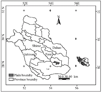 | |
| Fig. 1: | Map showing the location of the study area within the Fars province, Iran |
Also, hydrologically there is no surface water on the plain-the main source of water resources in the area is about 10 wells and two springs. The main soil type on the plain is lime. The region has a semi-arid climate With an average annual rainfall of 238.7 mm and a mean annual temperature is 22°C. The mean annual potential evaporation is 1459.6 mm.
In order to map desertification using on the MEDALUS model, the first four indices (soil, climate, vegetation and management indicators) have been created based on the original MEDALUS model.
For this purpose, the first step was to develop an environmental GIS database including maps and tables. Maps were compiled at a scale of 1:25000 containing each of the data layers shown in Table 1. In order to generate a database based on the layers in Table 1 each layer is treated as a product indicator within the MEDALUS model.
Soil indicator: In the soil indicator category different characteristics such as texture, depth and rock fragment were prepared. In this step, all of the studies and related maps have been collected and reproduced. After entering the data related to the GIS database, a map was produced for each of the soil characteristics as a separate layer. For this indicator seven data layers were prepared as indicated in Table 1. A slope gradient map based on a digital topographic map at a scale of 1:25000 from the National Cartographic Center (2005) and a Triangle Irregular Network (TIN) analysis (GIS-based) was prepared and classified into three classes (Table 1) following the MEDALUS manual (Kosmas et al., 1999). This table shows that about 68% of the study area has a slope less than 6%, i.e., gently sloped areas. Other data layers including parent material, soil depth, soil texture and soil rock fragment cover were used in the model based on land use evaluation map which had been prepared by the Research Institute of Land Evaluation of Iran (2004) at a scale of 1:250000. Also, Sodium Absorption Ratio (SAR) and Electricity Conductivity (EC) layers from the same institution were added to the data layers and used in the modified model. All of these layers were classified following MEDALUS guide recommendations.
Climatology indicator: For the preparation of the climatology indicator, seven existing meteorological stations around the plain consisting of Khosvieh, Ferg, Haji Abad, Fasa, Serov, Dehkoyeh and Baba Arab for period of 1973-2003 have been used. Three data layers were prepared based on calculations from these meteorological data, namely, the isohyte map, a De Martonne aridity index map and the FAO aridity index map. For the preparation of the isohyte map an annual rainfall map was produced using an Inverse Distance Weighting (IDW) method within the spatial analyst component of GIS and classified as shown in Table 1. The De Martonne aridity index map was developed using the following equation:
DI = P/(T+10) | (1) |
Where DI is the De Martonne aridity index, P is the annual precipitation (mm) and T is the annual mean temperature (°C). The resultant index was subsequently used in the model. Lastly, the FAO aridity index map was prepared based on the following equation:
FI = P/ETP | (2) |
Where FI is the FAO aridity index, P is the annual precipitation (mm) and ETP is the annual evapotranspiration (mm) estimated by using the Thornthwaite method (WMO, 1968). In the final step the calculated indices for all the meteorological stations were classified and a climatology indicator map was prepared.
Vegetation indicator: The basic source needed for the preparation of related data layers were a land use map of the studied area. This map was prepared using LANDSAT ETM 2002 satellite imagery using an unsupervised classification scheme where training areas were determined according to field studies and acceptable Kappa coefficients (Stehman, 1996) obtained from the Fars Natural Resource Organization (2003). The prepared land use map indicates the following percent land use distribution (in parentheses): rangelands (61.5), agricultural lands (24.5), destroyed rangelands (6.9) and bare lands (4.1). Other land uses in this area are residential, water bodies and rivers. Based on this map and an associated report (Fars Natural Resource Organization, 2003), the map of percent vegetation cover was prepared and classified according to the MEDALUS method.
Management indicator: For determining a land use management indicator, two main data layers, cattle and population densities, were developed.
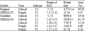
| Table 1: | Indicators used with related data layers and assigned weights in Iyzad Khast plain |
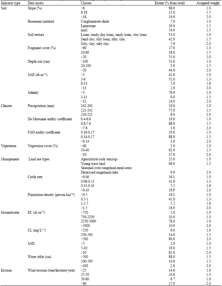 | |
The cattle density was calculated based on statistics of the cattle population according to the traditional nomad's boundaries across the studied area provided by the Fars Natural Resources Organization of Iran (2003) and a related classification map. Also, a population density map was calculated based on the Consensus Center of Iran (2005) following the same nomad boundaries together with a classification map.
Two new indicators, groundwater and erosion, were also prepared as follows.
Groundwater indicator: This indicator is derived from maps of Electric Conductivity (EC), SAR and chlor (CL) of groundwater and water table indices. To produce these maps, data from wells belonging to the Ministry of Energy (2005) was collected, based on the above attributes. Different thematic maps were prepared using a GIS interpolation function and in the final step these maps were classified based on their importance to desertification.
Erosion indicator: This indicator is based on two wind erosion and DSI index maps. The DSI index indicates the number of days with dust and storms that was extracted from meteorological station data. The erosion map of the study area was produced using a model developed by the Iran Research Institute of Forest and Rangeland (Ahmadi, 1997). The main framework of this model is based on the PSIAC model (Tangestani, 2005). A wind erosion map and an overall erosion map was prepared based on this model together with the analysis of geomorphologic, soil and vegetation maps and meteorological conditions, In the next step each of the indicators were weighted according to their relative impacts on desertification based on environmental conditions in the area. After weighting, the map for each of the indicators can be calculated as a geometric mean using the following equation:
ESA = (SQI * CQI* VQI* MQI)1/4 | (3) |
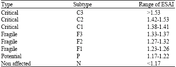
Where, ESA represents environmentally sensitive areas, SQI is a soil quality indicator, CQI is a climate quality indicator, VQI is a vegetation quality indicator and MQI is a Management quality indicator. The distribution of ESA is shown in Fig. 3. The range of ESA for each type is divided into critical and fragile types-a value less than 3-and non-affected areas-a value less than 1.17. Table 2 shows all of these categories following the MEDALUS manual (Kosmas et al., 1999a).
| Table 2: | Types of ESAs and corresponding ranges of indices (Kosmas et al., 1999) |
 | |
Although the original MEDALUS model was designed with reference to the Mediterranean region it is necessary to make adjustments to the indicators within the model according to the characteristics of each study area. These adjustments are focused here on the classification method and the assigned weights used. In this study, as a first step, the MEDALUS model was used in its original form with all the recommended data layers and specific weights but then an adjusted model was applied with two new indicators added together with related data layers. Therefore, in this study there lies the possibility of comparing the two models.
Due to the importance of hydrological and wind erosion conditions in land degradation (Hillel and Rosenzweig, 2002) two new indicators, groundwater and erosion, were added to the modified MODALUS model. Therefore, Eq. 3 is modified as follows:
ESA = (SQI * CQI* VQI* MQI* GQI* EQI)1/6 | (4) |
Where the two new indicators are: GQI (groundwater quality) and EQI (erosion quality).
Each of these additional parameters was weighted according to it’s effect on desertification (as described previously) based on the range of environmental conditions shown in Table 1.
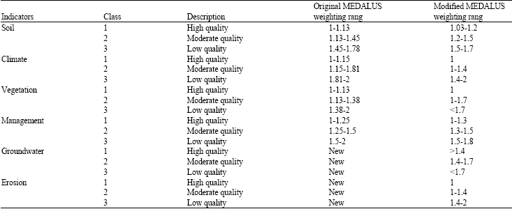
After weighting, the various information layers for each index were prepared in a suitable format and then overlaid in order to calculate the final value based on Eq. 3. In the modified model following Eq. 4, geometric means were calculated for six indicators (against four indicators in the original model). Then each of the maps was classified into three classes (low, moderate, high) as shown in Table 3. The map for each of the indices has been weighted based on area conditions. The maps were then and combined by using the above algorithm.
| Table 3: | Classes and weights of indicators in the original and modified models |
 | |
RESULTS
Figure 2 and 3 show maps of areas sensitive to desertification by using the original and modified MEDALUS models, respectively. Also Table 4 indicates the extent of each category (measured using GIS functions).
By using the original MEDALUS model it is clear that practically all of the plain, approximately 47274 ha is classed as critical (C3). Only 31 hectares are classified as fragile (F2). The C3 category has a climate that is characterized as semi-arid with rainfall ranging less than 220 mm with a De Martonne aridity index from 6.4 to 7.6. The plant cover is less than 10% including rangeland. According to the wind erosion map, this area is characterized as very high erosion with a DSI from 77 to 80 days a year. Such areas are usually dominated by coarse textured soils, with a shallow soil formed on a marl formation and limestone, with a soil EC of 12 dS m-1 and the groundwater table is less than 50 m,. The groundwater has a EC greater than 750 dS m-1, a CL greater than 250 mg L-1 and the SAR ranges from 5 to 10. In the C2 category, the soil texture is defined as moderately deep and stony with rock fragments covering between 30 to 40%. The plant cover is from 5 to 25% including agricultural land.
By contrast the modified MEDALUS model provides much more of a detailed spatial assessment of the ESA categories. According to Fig. 3 and Table 4, 19% of the plain is classified as C3, 62% as C2, 12% as C1. All three subtypes are critical regarding desertification. Also, 7% is classified as the fragile type, F2. In C1 classes, the climate is characterized as semi-arid.
The major desertification factors in the study area are due to land use changes resulting from an expanding population and over grazing.
| Table 4: | Extent of areas sensitive to desertification in the original and modified MEDALUS models |
 | |
In the F3 category, the rainfall ranged from 220 to 240 mm and the soil depth is greater than 50 cm with mainly textured silty loam with an EC rate of between 4 to 8 dS m-1. The groundwater Table is less than 50 m and the CL is greater than 350 mg L-1 The plant cover is between 10 to 40%. The F2 category is located in the northwest and is represented by rainfall greater than 240 mm and low wind erosion. In this class, the soil condition has a silt-loamy texture with soil depth of 50 cm and a high amount of lime and 30 to 40% rock fragment cover. SAR value is from 7 to 11 and the EC is about 8 dS m-1. The plant cover is between 10 to 40% and the main desertification factor is human activity (similar to the F3 class).
A comparison of the two maps produced indicates that the modified model represents desertification more realistically than the original model although it must be said that the modified model uses more indices (20 Vs 9). While in the original model the whole of the study plain is
categorized as critical with a high degree of desertification, it is impossible to determine the main determining factors. Because many factors can affect desertification and land degradation, it is obviously preferable to use more indicators or factors if the data quality of such indicators can be supported. Furthermore, the modified model has more classes from which it is easier to identify critical zones more accurately.
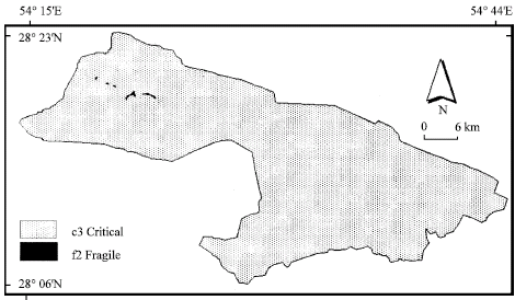 | |
| Fig. 2: | Map of ESA using the original MEDALUS model for the Iyzad Khast Plain |
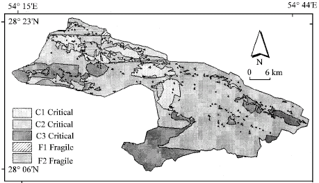 | |
| Fig. 3: | Map of ESA using the modified MEDALUS model for the Iyzad Khast Plain |
Also the weighting method used in these models is very different.
The weights used in the original model were designed for the Mediterranean area and cannot accurately represent an area such as Iran due to different environmental conditions including rainfall, vegetation cover and so on. Therefore, the design of new weights in this research specifically takes into account the characteristics of the region leading to more satisfactory results.
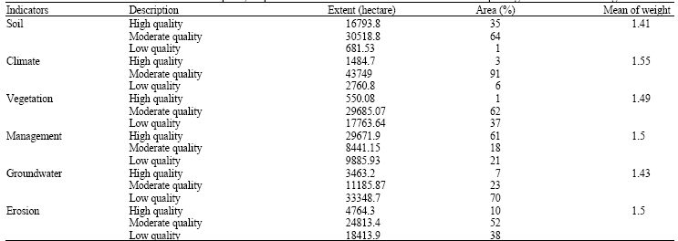
Based on six quality maps produced for the Iyzad Khast plain, the extents of each class are presented in Table 5. According to Fig. 3 the severity of the desertification hazard appears to increase from the north to the south. In other words, the northern part of the plain has fragile land use categories against critical categories in the southern parts.
In order to find out the most important factor affecting desertification, each quality map was compared with the final map. The comparing of these maps indicates that the climate quality indicator map most influenced the final one. This map shows that the area can be divided into semi-humid, semi-arid and arid climates, with 3, 91 and 6% of the land, respectively and are located in the north, centre and south of the studied plain. Also, the erosion indicator map shows the same conditions, with the severity of erosion increasing from north to south. In contrast to the other environmental quality maps, the groundwater quality map shows an inverse pattern due to the good quality of water in the south part of plain.
This Table 5 shows that the climate index, with a weighting mean of 1.55, is the most effective factor at depicting desertification over the study area. Wind erosion and land use management indicators are also strong indicators, with 1.5 tons/hectares/year that finally leading to desertification.
| Table 5: | The extents of each of the classes for six quality maps of considered indicators associated with their computed geometric mean of weights |
 | |
DISCUSSION
The recognition of areas under threat from desertification is the first step to decreasing their impacts in the environment. There are various factors that determine the occurrence of desertification in an area which vary in intensity and effect. Therefore, the determination of those main factors helps in the process of zonation of deserted areas. The best method and model of desertification zonation is the method that can easily use available data and information, one that can comprehensively assess all the important factors and apply some flexibility in the application of model weights assigned.
The result of this study indicates that MEDALUS method as original form may be has not required efficiency to represent of deserted areas, but the flexibility of model to accept new indicators, allow changes in the model and weights of all indicators used. In spite of satisfactory result of applying model in different geographic regions, the possibility of model to arrange into new form based on study area conditions is the good ability of the model. This possibility allows one can to evaluate the role of new added indicators to the original model and this is one of the most positive aspects of the MEDALUS method that the results of this study have showed which should allow for the better identification of deserted areas.
Considering to difference in physical conditions of deserted areas of the world it looks that groundwater conditions and wind erosion can be important role in developing of deserted areas. Therefore develop of regional model for deserted area based on applying areas conditions is required.
Recognizing and determining the relation between desertification intensity and the effective predictive factors can help with quantifying the desertification process. In some areas there may be a decrease in the water table due to desertification, while in other areas using an incorrect irrigation system can lead to an increase in deserted areas. These steps can also help to identify mitigation strategies. Also the MEDALUS model can help researchers and programmers through the use of weighted calculations of each indicator. For example, this study gave more weighting to climate indicators as the main factor determining desertification in the Iyzad Khast plain compared to other studied indicators.
According to the results of this investigation, MEDALUS is determined as the best method for studying the presence of desertification in this region because of its ability to use GIS compared to other traditional mapping methods.
We conclude that the MEDAUS method provides a satisfactory approach for identifying desertification-prone areas that need to be considered by the National Action Program. While the model attempts to assess and identify factors affecting desertification, it should be noted that the final maps are based on actual data.
Finally can be said the design and changes of original MEDAUS model based on specific conditions of each study area is necessary. In this way the recognizing of more important affected factors from analysis of the model is possible. Identification of effective factors can be used to present suitable policies in order to mitigate the desertification effects on the areas.
ACKNOWLEDGMENT
The author appreciates professor Peter Mayes (New Jersey Department of Environmental Protection, Trenton, U.S.A.) for reviewing the manuscript and for his useful comments.
REFERENCES
- Benjawan, C., P. Chutichudat, K. Boontiang and T. Chanaboon, 2006. Effect of chemical paclobutrazol on fruit development, quality and fruit yield of Kaew mango (Mangifera indica L.) in Northeast Thailand. Pak. J. Biol. Sci., 9: 717-722.
CrossRefDirect Link - Fernandez, J.A., L. Balenzategui, S. Banon and J.A. Franco, 2006. Induction of drought tolerance by paclobutrazol and irrigation deficit in Philyrea angustifolia during the nursery period. Sci. Hortic., 107: 277-283.
Direct Link - Marshall, J.G., R.G. Rutledge, E. Blumwald and E.B. Dumbroff, 2000. Reduction in turgid water volume in jack pine, white spruce and black spruce in response to drought and Paclobutrazol. Tree Physiol., 20: 701-707.
Direct Link - Nadia, M., Al-Khassawneh, N.S. Karam and R. Shibli, 2006. Growth and flowering of black iris (Iris nigricans Dinsm.) following treatment with plant growth regulators. Scientia Hortic., 107: 187-193.
Direct Link - Wieland, W.F. and L.R. Wample, 1985. Effects of paclobutrazol on growth, photosynthesis and carbohydrate content of delicious apples. Sci. Hortic., 26: 139-147.
CrossRefDirect Link