
Stang Abdul Rahman
Department of Biostatistics, Faculty of Public Health, Hasanuddin University, Indonesia
Amran Rahim
Department of Mathematic, Faculty of Mathematic and Natural Sciences, Hasanuddin University, Indonesia
Anwar Mallongi
Department of Environmental Health, Faculty of Public Health, Hasanuddin University, Indonesia
LiveDNA: 62.16355
Journal of Entomology
Year: 2017 | Volume: 14 | Issue: 1 | Page No.: 49-57


ABSTRACT
Background: Standard statistical models generally assume that any incident of dengue disease in one location are independent with the incidence of dengue disease in other locations. However, the independent assumption does not apply in the spread of dengue disease. The spread of dengue disease tends to occur almost simultaneously in a same area or in the adjacent area due to similar environmental factors in the area. Similar environmental factors results in their risk spatial correlation of disease spread. If spatial correlation aspects is not considered in modeling then the conclusion of the significant factors that influence on the risk of spreading disease becomes inaccurate. Objective: The purpose of this study was to make mapping the risk of dengue fever incidence in Bone Regency South Sulawesi province by region (districts) with non-stationary spatial geostatistics model. Materials and Methods: The analysis variables included are larvae density, temperature, population density, rainfall, altitude from sea level and the incidence rate of dengue fever. Results: The results showed that risk rate model of dengue in Bone Regency with stationary spatial geostatistics models are as follows: log(pi) = -0.08+0.006X1+0.02X2-0.02X3-0.04X4-0.01X5. X1 = The density of larvae, X2 = Air temperature, X3 = Population density, X4 = Rainfall and X5 = The height of the sea level. Risk rate model of dengue in Northern Bone Regency (cluster 1) with non-stationary spatial geostatistics models are as follow: log(pi) = -0.02-0.0009X1-0.17X2+0.003X3+0.22X4-0.006X5. Risk rate model of dengue in Southern Bone Regency (cluster 2) with non-stationary spatial geostatistics models are as follow: log(pi) = -0.02-0.02X1-0.01X2-0.02X3-0.02X4-0.03X5. Risk rate model of dengue in Western Bone Regency (cluster 3) with non-stationary spatial geostatistics models are as follow: log(pi) = -0.08-0.007X1-0.02X2-0.03X3-0.009X4-0.06X5. Conclusion: The prediction error values on the non-stationary model between (0.27-3.6) lower than stationary model with variation between (0.68-6.37).
PDF Abstract XML References Citation
Received: October 04, 2016;
Accepted: November 28, 2016;
Published: December 15, 2016
Copyright: © 2017. This is an open access article distributed under the terms of the creative commons attribution License, which permits unrestricted use, distribution and reproduction in any medium, provided the original author and source are credited.
How to cite this article
Stang Abdul Rahman, Amran Rahim and Anwar Mallongi, 2017. Forecasting of Dengue Disease Incident Risks Using Non-stationary Spatial of Geostatistics Model in Bone Regency Indonesia. Journal of Entomology, 14: 49-57.
DOI: 10.3923/je.2017.49.57
URL: https://scialert.net/abstract/?doi=je.2017.49.57
DOI: 10.3923/je.2017.49.57
URL: https://scialert.net/abstract/?doi=je.2017.49.57
INTRODUCTION
Dengue fever is a contagious disease that causes disturbances in capillary blood vessels and blood clotting system resulting in bleeding and can cause death in the data of Health Department of Republic of Indonesia1 shows every year 50 million people are infected with dengue virus and 500,000 of them had to be hospitalized or one person every minute. The largest proportion attacked by DHF is children. Reported every year 21,000 children die of dengue or one child every 20 min. Estimated 2.5-3 billion people at risk of dengue virus infection2.
Cases of dengue fever has spread across the districts in the province of South Sulawesi. Bone Regency is one of regencies in South Sulawesi with high incidence of dengue cases also include in heavy endemic areas. The incidence of dengue fever in 2012 there were 412 cases or rate incidence 54/100.000 population, in 2013 increased to 603 cases or rate incidence 79/100.000 population, 2014 decreased to 303 cases or rate incidence3-5 40/100.000.
Mapping the risk of spread of dengue can be used as a guide preparation of a strategic precaution for the optimization of human resources and funding sources. The DHF risk mapping can also be used to develop early warning systems to make predictions of the outbreak area were due to changes in environmental factors.
Statistical models generally assumed that every incidence of disease in a given location is independent with the incidence of the disease in other locations6. However, the independent assumption does not apply in the spread of dengue disease. The spread of dengue disease tends to occur almost simultaneously in a same area or in adjacent areas due to similar environmental factors in the area. Similar environmental factors results in spatial correlation of spreading disease risk. If spatial correlation aspects is not considered in the modeling, the conclusions about the factors that have significant influence on the risk of the spread of the disease become inaccurate4.
Another approach that is often used to estimate parameters of geostatistics models are Bayesian methods known as Bayesian geostatistics models, Bayes methods introduced by Diggle et al.7 and has been used in the model of the spatial distribution of the spread of parasitic diseases7-13. Generally, the application of Bayesian geostatistics models are based on the stationary assumption. Stationary assumptions has implications for the use a spatial correlation function that depends only on the function of the distance between locations without considering the location of the site itself. This assumption tends to not be met at the spread of dengue disease models because the local characteristics associated with human activity, land use, environmental factors and the influence of ecology affects the spatial correlation differently at different locations.
In this study non-stationary geostatistics Bayesian model proposed as the development of stationary geostatistics Bayesian models and the results will be compared with stationary geostatistics Bayesian models to make a prediction map and analyze the risk of the spread of dengue disease in Bone regency. Through a combination of non-stationary spatial models and geostatistics Bayesian models will be shown that the combination of the model can explain the prediction risk of spread of dengue disease better than the stationary spatial model which do not consider the diversity of spatial correlation in an observation area. The advantages proposed model is able to map the location of the spread of dengue disease with similar characteristics in the observation area so that the intervention procedure can be done with an efficiently.
MATERIALS AND METHODS
Types of research: This study is mapping the risk of incidence of dengue fever in Bone Regency, South Sulawesi province by region (sub-district) by the incidence rate data changes and predictor variables that influence the dengue fever incidence.
Analysis unit: The analysis unit in this study were 27 districts in Bone, by calculating the incidence rate data changes and the predictor variables that influence dengue fever incidence. Mapping done by using a statistical model of the risk rate considering spatial effects and incidence rate temporal effects. Mapping implementation stages are monitoring in each district for larvae density, temperature, population density, rainfall, the level of a point above sea level and the incidence rate of dengue fever.
Data retrieval and collection procedures: Collecting data on the density of larvae and the incidence rate of dengue fever, the level of a point above sea level and population density done by direct survey in each district. While data on air temperature and rainfall are taken from meteorology, climatology and geophysics Bureau of Maros Regency.
Data processing and analysis: Data analysis using stationary spatially geostatistics models and non-stationary with program ArcView GIS version 3.3 and Open Bugs.
RESULTS
Stationary spatial geostatistics: Results of stationary model and non-stationary model analysis can be expressed in the form of maps. Stationary model suggests that the following environmental factors associated with the risk of dengue fever: Larvae density, temperature, population density, rainfall and altitude from sea level. The results analysis of incidence rate of dengue fever risk using spatial geostatistics stationary model is obtained as follows:
log(pi) = -0.08+0.006X1+0.02X2-0.02X3-0.04X4-0.01X5
Where:| X1 | = | Density of larvae |
| X2 | = | Temperature of air |
| X3 | = | Population density |
| X4 | = | Rainfall |
| X5 | = | Height of the sea level |
From the results using stationary spatial geostatistics, spatial maps of dengue fever risk prediction can be made as Fig. 1.
Non-stationary spatial geostatistics: Result analysis of non-stationary spatial geostatistics model Bone Regency split into three clusters based on the regionalism characteristic of each district. Cluster 1 consists of the district: Awampone, Tanete Riattang Timur, Barebbo, Tanete Riattang, Cenrana, Cina, Dua Boccoe, Tellu Siattinge, Palakka, Sibulue and Tanete Riattang Barat. Cluster 2 consists of the district: Bonto Cani, Kahu, Kajuara, Libureng, Mare, Patimpeng, Salomekko and Tonra. Cluster 3 consists of the district: Ajangale, Ponre, Tellu Limpoe, Bengo, Lamuru, Lappariaja, Amali and Ulaweng.
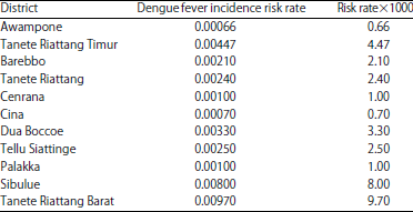
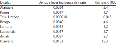
The analysis results of dengue fever incidence risk rate with non-stationary spatial geostatistics model in cluster 1 can be seen in the Table 1.
Table 1 explains that in Tanete Riattang Barat district can predict there will be 9.7 or 10 people affected by dengue fever per 1000 population without intervention of the relevant government. Similarly in Sibulue district can predict there will be 8 people affected by dengue fever per 1000 population. Lowest incidence is in Awampone district can predict there will be 0.66 or 1 people affected by dengue fever per 1000 population.
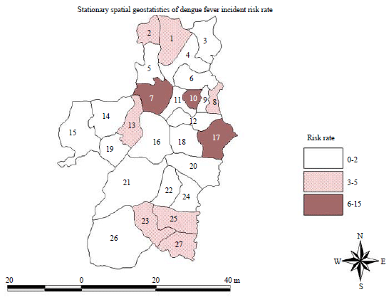 | |
| Fig. 1: | Dengue incident risk rate predication map with stationary spatial geostatistics. Information: Code area of 27 districts in Bone, (1) Dua Boccoe Lappariaja, (2) Ajangale, (3) Cenrana, (4) Tellu Siattinge, (5) Amali, (6) Wampone, (7) Ulaweng, (8) Tanete Riattang Timur, (9) Tanete Riattang, (10) Tanete Riattang Barat, (11) Palakka, (12) Barebbo, (13) Bengo, (14) Lamuru, (15) Tellu Limpoe, (16) Ponre, (17) Sibulue, (18) Cina, (19) Awampone, (20) Mare, (21) Libureng, (22) Patimpeng, (23) Kahu, (24) Tonra, (25) Salomekko, (26) Bontocani and (27) Kajuara |
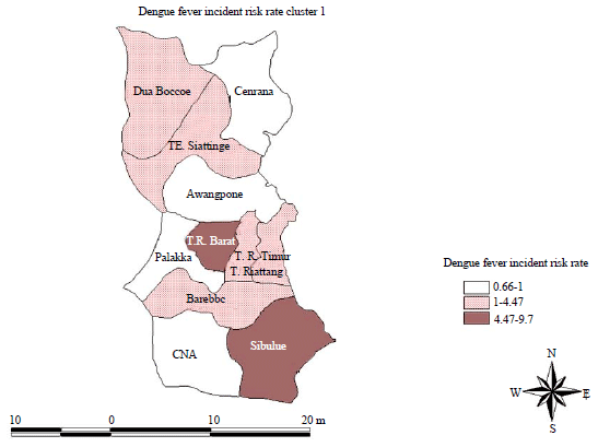 | |
| Fig. 2: | Map of dengue fever incident risk rate prediction cluster 1 with non-stationary spatial geostatistics |
| Table 1: | Analysis results of dengue fever risk incidence rate with non-stationary spatial geostatistics model in cluster 1 |
 | |
| Table 2: | Analysis results of dengue fever risk incidence rate with non-stationary spatial geostatistics model on cluster 2 |
 | |
Equation model of dengue fever risk rate for cluster 1 can be obtained as follows:
log(pi) = -0.02-0.0009X1-0.17X2+0.003X3+0.22X4-0.006X5
Where:| X1 | = | Density of larvae |
| X2 | = | Temperature of air |
| X3 | = | Population density |
| X4 | = | Rainfall |
| X5 | = | Height of the sea level |
From the results of Table 1, spatial maps of dengue fever risk prediction can be made as Fig. 2.
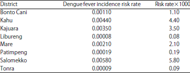
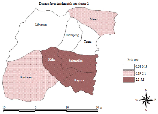
Analysis result of dengue fever incident risk rate with non-stationary spatial geostatistics model on cluster 2 consisting of the district: Bonto Cani, Kahu, Kajuara, Libureng, Mare, Patimpeng, Salomekko can be seen in Table 2.
Table 2 explains that in Salomekko district can predict there will be 5.8 or 6 people affected by dengue fever per 1000 population without intervention of the relevant government. As well as in Kahu district can predict there will be 4.4 or 5 people affected by dengue fever per 1000 population. Lowest incidence is in Libureng district can predict there will be 0.09 people affected by dengue fever per 1000 population. Equation model of dengue fever risk rate for cluster 2 can be obtained as follows:
log(pi) = -0.02-0.02X1-0.01X2-0.02X3-0.02X4-0.03X5
Where:| X1 | = | Density of larvae |
| X2 | = | Temperature of air |
| X3 | = | Population density |
| X4 | = | Rainfall |
| X5 | = | Height of the sea level |
 | |
| Fig. 3: | Map of dengue fever incident risk rate prediction cluster 2 with non-stationary spatial geostatistics |
| Table 3: | Analysis results of dengue fever risk incidence rate with non-stationary spatial geostatistics model on cluster 3 |
 | |
From the results of Table 2, spatial maps of dengue fever risk prediction can be made as Fig. 3.
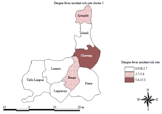
Analysis result of dengue fever incident risk rate with non-stationary spatial geostatistics model on cluster 3 consisting of the district: Ajangale, Ponre, Tellu Limpoe, Bengo, Lamuru, Lappariaja, Amali and Ulaweng can be seen in Table 3.
Table 3 explains that in Ulaweng district can predict there will be 15.3 or 16 people affected by dengue fever per 1000 population without intervention of the relevant government. As well as in Ajangale district can predict there will be 5.4 or 6 people affected by dengue fever per 1000 population. Lowest incidence is in Tellu Limpoe district can predict there will be 0.0018 people affected by dengue fever per 1000 population. Equation model of dengue fever risk rate for cluster 3 can be obtained as follows:
log(pi) = -0.08-0.007X1-0.02X2-0.03X3-0.009X4-0.06X5
Where:| X1 | = | Density of larvae |
| X2 | = | Temperature of air |
| X3 | = | Population density |
| X4 | = | Rainfall |
| X5 | = | Height of the sea level |
From the results of Table 3, spatial maps of dengue fever risk prediction can be made as Fig. 4.
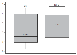
Predictive ability comparison of model stationary and non-stationary model: To see the predictive ability of the stationary and non-stationary models, the median value of each model shown in Fig. 5.
Figure 5 compares the predictive ability of the stationary and non-stationary model. Logistic regression model use "p-value" approach in the inference process. Each box plot figuring "p-value" distribution calculated from the predictive posterior distribution from 27 districts locations. Median of this distribution for non-stationary models is closest to 0.5, indicates that the non-stationary models is a better model than the stationary model. The same conclusion was drawn by comparing models using chi-squared approach. Figure 5 shows that the non-stationary models have the same median of value distribution for 27 districts locations, however non-stationary model has the lowest deviant value, shows the smallest deviation between observation and prediction models.
 | |
| Fig. 4: | Map of dengue fever incident risk rate prediction cluster 3 with non-stationary spatial geostatistics |
 | |
| Fig. 5: | Box plot of the stationary and non-stationary model median value |
Stationary model calculates the posterior median for equal to 0.068 (confidence interval 95%: 0.025, 0.098) shows that the minimum distance with spatial correlation smaller than 5% equal to 3/ρ = 44.12 km. Matching results of non-stationary models indicate that spatial correlation changed, from the Eastern region to the West. The prediction error values on non-stationary model lower than the stationary model, starting from 0.27-3.6 compared with obtained from stationary one with variation 0.68-6.37.
DISCUSSION
Dengue fever accurate risk map is an important tool in controlling dengue because it can guide interventions and assess its effectiveness. These maps rely on risk prediction in a location without risk data observations. Dengue is a disease of the environment and environmental factors are good predictors on transmission but the relationship between environmental factors, density of larvae and the risk of dengue is not linear. This relationship can be established only by spatial statistical models which can be used for increasing the dengue transmission prediction not only in space (for risk mapping) but also in time (to develop an early warning system of dengue epidemic).
Characteristics of Bone Regency has diverse ecological patterns. Bone Regency is a region with local rainfall patterns. The rainfall pattern in Bone Regency different with rainfall patterns in other regencies in South Sulawesi province that follow the equatorial and monsoon rainfall pattern. Because of the breadth of Bone and border have different rainfall patterns, it makes ecological characteristics in Bone Regency varied so that a stationary model approach becomes less realistic. Observation area division method on several zones is a new approach in risk mapping and can be implemented in analyzing dengue risk data14.
In this study, Bone Regency partition based on North, South and West region with the consideration that these three regions vary in height from sea level. Bone Northern region in general has a low height from sea level. Bone Western region has a high height of sea surface. The altitude differences affect the difference in air temperature and density of larvae. The higher a site from sea level, the lower the air temperature at that location. This finding is in line with the previous study by Chowell et al.13, Mallongi et al.15 and Stang et al.16 revealed that geographic and climate factors influence on the timing of dengue epidemics. The proliferation of larvae is very dependent on air temperature. Environment with cold temperatures are not suitable for the breeding of larvae. Because of this characteristics differences, this study used a non-stationary model approach.
Research results with non-stationary spatial geostatistical approach obtained that northern Bone regency have high risk rate particularly in Tanete Riattang Barat district. In Tanete Riattang Barat can predict there will be 9.7 or 10 people affected by dengue fever per 1000 population without intervention of the relevant government. As well as in Sibulue district can predict there will be 8 peoples affected by dengue fever per 1000 population. Lowest incidence is in Awampone district predict there will be 0.66 or 1 people affected by dengue fever per 1000 population. Equation model of dengue fever risk rate can be obtained as follows:
log(pi) = -0.02-0.0009X1-0.17X2+0.003X3+0.22X4-0.006X5
Where:| X1 | = | Density of larvae |
| X2 | = | Temperature of air |
| X3 | = | Population density |
| X4 | = | Rainfall |
| X5 | = | Height of the sea level |
This model is very useful for the government to predict the risk rate in each district particularly Northern Bone Regency. With this model any environmental variables change in each district can predict the risk rate of dengue incident. By knowing the dengue incident risk rate would facilitate government or related agencies to intervene on target.
Analysis result for Southern Bone Regency obtained highest dengue incident risk rate in Salomekko district. In Salomekko district can predict there will be 5.8 or 6 peoples affected by dengue fever per 1000 population without intervention of the relevant government. As well as in Kahu district can predict there will be 4.4 or 5 peoples affected by dengue fever per 1000 population. Lowest incidence is in Libureng district predict there will be 0.09 people affected by dengue fever per 1000 population. Equation model of dengue fever risk rate can be obtained as follows:
log(pi) = -0.02-0.02X1-0.01X2-0.02X3-0.02X4-0.03X5
Where:| X1 | = | Density of larvae |
| X2 | = | Temperature of air |
| X3 | = | Population density |
| X4 | = | Rainfall |
| X5 | = | Height of the sea level |
By looking at these results is certainly the government should prioritize tackling the incidence of dengue fever in the Salomekko and Kahu district. Environmental changes factors will certainly change the risk rate in each district so maybe next year Salomekko district not a priority to eradicate the incidence of dengue fever. With the dengue incident risk rate model particularly in Bone Southern region the government would be easier to proper and efficient intervene.
Analysis result for western Bone regency obtained highest dengue incident risk rate in Ulaweng district. In Ulaweng district can predict there will be 15.3 or 16 peoples affected by dengue fever per 1000 population without intervention of the relevant government. As well as in Ajangale district can predict there will be 5.4 or 6 peoples affected by dengue fever per 1000 population. Lowest incidence is in Tellu Limpoe district predict there will be 0.0018 people affected by dengue fever per 1000 population. Equation model of dengue fever risk rate for cluster 3 can be obtained as follows:
log(pi) = -0.08-0.007X1-0.02X2-0.03X3-0.009X4-0.06X5
Where:| X1 | = | Density of larvae |
| X2 | = | Temperature of air |
| X3 | = | Population density |
| X4 | = | Rainfall |
| X5 | = | Height of the sea level |
By looking at these results is certainly the government should prioritize tackling the incidence of dengue fever in the Ulaweng and Ajangngale district. Environmental changes factors will certainly change the risk rate in each district so maybe next year Ulaweng and Ajangngale district not a priority to eradicate the incidence of dengue fever. With the dengue incident risk rate model particularly in Bone Western region the government would be easier to proper and efficient intervene.
CONCLUSION AND RECOMMENDATIONS
| • | Risk rate model of dengue fever in Bone Regency with stationary spatial geostatistics models as follow: |
log(pi) = -0.08+0.006X1+0.02X2-0.02X3-0.04X4-0.01X5
Where:| X1 | = | Density of larvae |
| X2 | = | Temperature of air |
| X3 | = | Population density |
| X4 | = | Rainfall |
| X5 | = | Height of the sea level |
| • | Risk rate model of dengue fever in Northern Bone Regency with non-stationary spatial geostatistics model as follow: |
log(pi) = -0.02-0.0009X1-0.17X2+0.003X3+0.22X4-0.006X5
| • | Risk rate model of dengue fever in Southern Bone Regency with non-stationary spatial geostatistics model as follow: |
log(pi) = -0.02-0.02X1-0.01X2-0.02X3-0.02X4-0.03X5
| • | Risk rate model of dengue fever in Western Bone Regency with non-stationary spatial geostatistics model as follow: |
log(pi) = -0.08-0.007X1-0.02X2-0.03X3-0.009X4-0.06X5
| • | The prediction error values on non-stationary model between (0.27-3.6) lower than stationary model between (0.68-6.37) |
| • | Bone government more focus on preparing the program for eradication of Aedes aegypti mosquito larvae simultaneously in each district especially those that have a high rate dengue fever incidence risk |
| • | Environment management through 3 M continuously and simultaneously in each district especially those that have a high rate dengue fever incidence risk |
| • | Need application spatial geostatistics models of non-stationary spatial to any case or other location thus further demonstrate the advantages and benefits |
SIGNIFICANCE STATEMENTS
Generally, models of statistics assumed that every incidence of disease in a given location is independent with the incidence of the disease in other locations. However, the independent assumption does not apply in the spread of dengue disease. The spread of dengue disease tends to occur almost simultaneously in a same area or in adjacent areas due to similar environmental factors in the area. In this study, applying stationary geostatistics Bayesian models able to make a prediction map and analyze the risk of the spread of dengue disease in Bone Regency. Applying this model is able to map the location of the spread of dengue disease with similar characteristics in the observation area so that the intervention procedure can be done with an efficiently.
ACKNOWLEDGMENTS
Authors would like to express grateful thanks to the Chief of Bone Regency who have given a permission to conduct this study and those health staffs and all communities in the area who have very cooperative in giving contribution in data collection process. We also would like to thank to DEAD. who have funded this study as one of the Indonesian Education program.
REFERENCES
- Diggle, P., R. Moyeed, B. Rowlingson and M. Thomson, 2002. Childhood malaria in the Gambia: A case-study in model-based geostatistics. J. R. Stat. Soc. Ser. C: Applied Stat., 51: 493-506.
CrossRefDirect Link - Gemperli, A. and P. Vounatsou, 2003. Fitting generalized linear mixed models for point reference data. J. Mod. Applied Stat. Methods, 2: 497-511.
CrossRefDirect Link - Raso, G., P. Vounatsou, L. Gosoniu, M. Tanner, E.K. N'Goran and J. Utzinger, 2006. Risk factors and spatial patterns of hookworm infection among schoolchildren in a rural area of Western Cote d'Ivoire. Int. J. Parasitol., 36: 201-210.
CrossRefDirect Link - Abdulla, S., A. Gemperli, O. Mukasa, J.R.M.A. Schellenberg, C. Lengeler, P. Vounatsou and T. Smith, 2005. Spatial effects of the social marketing of insecticide-treated nets on malaria morbidity. Trop. Med. Int. Health, 10: 11-18.
CrossRefDirect Link - Clements, A.C.A., N.J.S. Lwambo, L. Blair, U. Nyandindi and G. Kaatano et al., 2006. Bayesian spatial analysis and disease mapping: Tools to enhance planning and implementation of a schistosomiasis control programme in Tanzania. Trop. Med. Int. Health, 11: 490-503.
CrossRefDirect Link - Eckert, N., E. Parent, L. Belanger and S. Garcia, 2007. Hierarchical Bayesian modelling for spatial analysis of the number of avalanche occurrences at the scale of the township. Cold Regions Sci. Technol., 50: 97-112.
CrossRefDirect Link - Chowell, G., B. Cazelles, H. Broutin and C.V. Munayco, 2011. The influence of geographic and climate factors on the timing of dengue epidemics in Peru, 1994-2008. BMC Infect. Dis., Vol. 11.
CrossRefDirect Link - Amran, I. Nur, Subiono and Irhamah, 2013. Identification and characterization of extreme rainfalls distribution in Malang residence. J. Math. Stat., 9: 376-385.
Direct Link - Mallongi, A., P. Pataranawat and P. Parkpian, 2014. Mercury emission from artisanal buladu gold mine and its bioaccumulation in rice grains, Gorontalo Province, Indonesia. Adv. Mater. Res., 931-932: 744-748.
CrossRefDirect Link