
P.R. Ikhane
Department of Earth Sciences, Olabisi Onabanjo University, Ago-Iwoye, Nigeria
K.O. Omosanya
Department of Earth Sciences, Olabisi Onabanjo University, Ago-Iwoye, Nigeria
A.A. Akinmosin
Department of Geosciences, University of Lagos, Akoka, Lagos, Nigeria
A.B. Odugbesan
Department of Earth Sciences, Olabisi Onabanjo University, Ago-Iwoye, Nigeria
Journal of Applied Sciences
Year: 2012 | Volume: 12 | Issue: 8 | Page No.: 716-726


ABSTRACT
Outcrop analog are important tools for better understanding of large scale seismic features such as slope deposits and structures. Sedimentary exposures at Ijebu Omu, Itele and Ijebu Ife, all within the eastern part of Dahomey basin, Southwest Nigeria were imaged using Electrical geophysical method with the aim of reconstructing the geological history of the area and providing a basis for understanding larger scale structures. The Electrical Resistivity Imaging was done using a Wenner array configuration with a -spacing of multiples of 5 m; the result was iterated using RES2DINV. Both smooth and robust inversion of the apparent resistivity data was carried out. From the geologic models, dimension of structures were determined and three dimensional evolutionary diagrams were drawn. Six (6) geo-electric facies were identified from the three locations; they include clay, resistive clay, sand, sandstone, compacted sandstone and conglomerate with average resistivity value of ~16.27 Ωm, ~58 Ωm, ~392 Ωm, ~1264 Ωm, ~2196 Ωm and ~4633 Ωm, respectively. The meandered sandy bodied channels identified at Ijebu Omu have aspect ratios of ~4.00, ~1.37, ~2.59 and ~3.13, respectively, those at Itele ~5.9 and ~7.30 and the one at Ijebu-Ife ~3.19; meanwhile ~5 m, ~8 m and ~8.5 m thick clastic dykes were seen at Itele. Due to their high aspect ratios, the sinuosity of the channels in the study area is very high, thus the conclusion that they are meandering. The clastic dykes at Itele were formed as a result of overburden pressure and undercompaction typical of soft sediment deformation or syn-sedimentary deformation.
PDF Abstract XML References Citation
Received: January 24, 2012;
Accepted: March 31, 2012;
Published: June 20, 2012
How to cite this article
P.R. Ikhane, K.O. Omosanya, A.A. Akinmosin and A.B. Odugbesan, 2012. Electrical Resistivity Imaging (ERI) of Slope Deposits and Structures in Some Parts of Eastern Dahomey Basin. Journal of Applied Sciences, 12: 716-726.
DOI: 10.3923/jas.2012.716.726
URL: https://scialert.net/abstract/?doi=jas.2012.716.726
DOI: 10.3923/jas.2012.716.726
URL: https://scialert.net/abstract/?doi=jas.2012.716.726
INTRODUCTION
Suitable outcrop analogues can be closely studied in order to visualize sand-body geometry and reservoir architecture and for numerical inputs into reservoir models (Higgs, 2004). The rationales for this study is to image slope deposits and structures, and provide a platform for understanding the origin of larger scale seismic structures.
Slope deposits are sedimentary product of gravitational movement of sediments along slopes or channels; they include mass transport deposits such as slides, slumps and debris flow and turbidites (Mruk and Bebout, 2007). These deposits are important seal and reservoir rocks in the deepwater environments and understanding their mechanisms, distribution and scales of occurrence is important for subsurface investigations and reservoir evaluation.
Unlike igneous intrusions, clastic dykes are found in sedimentary basin deposits worldwide. Formal geologic reports of clastic dyke began to emerge in the early 19th century. This kind of soft-sediment deformation structures have been described to occur from a variety of environments such as lacustrine, fluvial, aeolian, reef and continental slope (Ribeiro and Terrinha, 2007). The lithologies involved in most of the published case studies are mudstones and sandstones, calciclastic limestones, dolomites and evaporitic sediments (Molina et al., 1997; Matsuda, 2000; Jones and Omoto, 2000; Alfaro et al., 2002; Rossetti and Santos, 2003; McLaughlin and Brett, 2004; Bachmann and Aref, 2005; Ribeiro and Terrinha, 2007), causal mechanisms that triggered slope instability include, seismic activity (earthquakes), gas hydrate dissociation, gravitational instabilities, overloading as a result of rapid sedimentation sometimes resulting in unequal sediment loading.
This work is aimed at imaging slope processes and deposits (clastic dyke and channels) in parts of the Cretaceous Abeokuta group, Eastern Dahomey basin with a view to reconstructing the geological history of the study area and providing analog to enhance subsurface investigations in the study area. The paper starts by describing the geographic and geological setting of the study area, the Stratigraphy of the Eastern Dahomey basin, methods used and models for the interpretation. It is concluded by making comparison with previous research work done elsewhere.
MATERIALS AND METHODS
Local setting: The study area is located within the eastern part of Dahomey basin, Southwest of Nigeria between Latitude 06°44' - 06°47' and Longitude 003°58' - 003°60', an area that transcends important locality such as Epe, Ijebu Ife, Itele and Omu (Fig. 1). The outcrops are exposed as road cuts in an area of undulating lowlands belonging to the coastal sedimentary rocks of western Nigeria. There are scattered hills that are interfluves between the different river valleys. The drainage system observed in the study area is sub-dendrite like as they are characterised by irregular branching of tributary streams in many directions at almost any angle; temperatures ranges from 22-32°C, (Onakomaiya et al., 1992). The average annual rainfall varies from 150-160 cm. The wet season begins in late March/early April and ends in mid October. Previous work in the area include Jones and Hockey (1964), Omatsola and Adegoke (1981), Burke et al. (1971), Elueze and Nton (2004), Adegoke (1977), Adegoke et al. (1980), Enu (1985) and Olabode (2006). The exposures of the study area belong to the Abeokuta group of the eastern Dahomey basin, because of the lithological makeup and field observation the rock are thought to be part of the Ise Formation.
REGIONAL GEOLOGIC SETTING
The Dahomey basin is an inland, offshore, coastal sedimentary basin in the Gulf of Guinea; it extends from southeastern Ghana through Togo and Benin Republic to the Okitipupa ridge/Benin Hinge line in Nigeria. The axis of the basin and the thickest sediments occur slightly west of the border between Nigeria and the Republic of Benin (Billman, 1976). The Dahomey Basin is bounded on the west by faults and other tectonic structures associated with the landward extension of the Romanche Fracture zone. Its eastern limit is also marked by the Benin Hinge line, a major fault structure marking the western limit of the Niger Delta Basin. The tertiary sediments of the Dahomey Basin thin out and are partially cut off from the sediments of the Niger Delta Basin against the ridge of basement rocks.
The basin evolved during the rifting stage in the Lower Jurassic-Early Cretaceous of the Godwanaland as a result of basement fracturing (Storey, 1995; Mpanda, 1997); several margins developed at this time both on continental African and South American (Asmus and Ponte, 1973; Ojeda, 1982; Omatsola and Adegoke, 1981) and the most significant implication of this event was the development of the Southern Atlantic ocean and passive margins.
Stratigraphy of the eastern Dahomey basin: Jones and Hockey (1964), Omatsola and Adegoke (1981), Coker et al. (1983), Billman (1992), Nton (2001), Elueze and Nton (2004), Nton and Elueze (2005), Nton et al. (2006) and Reyment (1965) amongst other workers studied the stratigraphy of Dahomey basin using surface and subsurface data (Table 1).
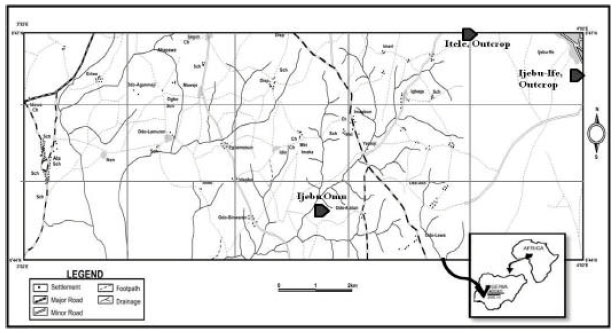 | |
| Fig. 1: | Index map of the study area |
| Table 1: | The Stratigraphic units of Eastern Dahomey Basin |
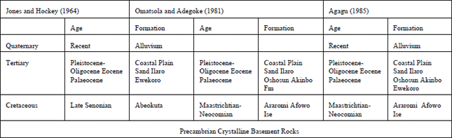 | |
Controversies associated with Stratigraphic column borders around misuse of stratigraphic names for the same Formation in different localities in the basin (Billman, 1992; Coker et al., 1983), no thanks to the sparse borehole coverage and outcrops for good stratigraphic studies and correlation.
Abeokuta group: This unit overlies the basement complex unconformably along the entire basin. Rocks found in this group include conglomerates, sandstone, sandy siltstone, clay, shale and thin limestone beds (Jones and Hockey, 1964). Omatsola and Adegoke (1981) referred to the Abeokuta group as the thickest sedimentary units in the entire basin. This group is subdivided into:-
Ise formation: It consists essentially of conglomerates and grits at its base and in turn is overlain by coarsed to medium grained sands with interbedded kaolinite. The conglomerates are unimbricated and at some locations, ironstones occur (Nton, 2001). Neocomian to Albian age has been assigned to this Formation. The maximum thickness of the member is ~1865 m and more than 600 m of it was penetrated by Ise-2 boreholes.
Afowo formation: Coarse to medium-grained sandstones with variable interbeds of shale, siltstones and clay (Omatsola and Adegoke, 1981; Agagu, 1985) overlying the Ise Fm. The sediments of this formation were deposited in transitional to marginal marine environment during the Turonian-Maastrichian time. The shales are rich in organic matter and the sands are tar bearing; based on palynomorph content, the Afowo Fm is Neocomian in age.
Araromi formation: This formation is composed of fine to medium grained sands at the base, overlain by shale and siltstones with thin interbedded limestone and marls. Thin lignitic bands are also common. The Shales are light grey to black, mostly marines and with very high organic content. The formation is equivalent to the upper part of the Awgu formation and the Nkporo shale of the Anambra basin (Billman, 1976). The age ranges from Maastrichtian to Paleocene. The formation is rich in fossils, bearing abundant planktonic foraminifera, ostracods, pollen and spores. The flora of the tar sand bearing sections near Agbadu was described in details by Jan du Chene et al. (1978).
The Abeokuta group is overlain by the Imo group which include the Ewekoro Formation and Akinbo Formation (Agagu, 1985), the Oshoshun Formation (Agagu, 1985; Kogbe, 1976; Ajayi et al., 2006), the Coastal Plain/Benin Sands (Jones and Hockey, 1964) and the Recent Alluvium (Jones and Hockey, 1964).
METHODS
The electrical resistivity technique was used in this investigation, it is a geophysical methods that has found great application in the exploration and evaluation of groundwater potential and properties (Sirhan et al., 2011; Ekinci et al., 2008; Ehirim and Ofor, 2011; Batayneh et al., 2004; Majumdar and Das, 2011; Nwankwo, 2011), geology and structures (Leucci, 2006; Skjernaa and Jorgensen, 1993; Al-Hagrey, 1994; Boadu et al., 2005), soil properties investigation (Molindo and Alile, 2007), Hydrocarbon exploration (Ikhane et al., 2011) just to mention a few. Electrical Resistivity Imaging (ERI) or Tomography (ERT) are advances to conventional Vertical Electrical Sounding (VES) and Constant Separation Traversing (CST).
In this research Electrical resistivity imaging (ERI) was employed to delineate the lateral and vertical variation in the subsurface resistivity properties along the survey line. The Wenner array was used with an electrodes spacing of “1a”; where a = 5 m. For the first measurements, electrodes number 1, 2, 3 and 4 were used. Electrode 1 was used as the first current electrode (C1), electrode 2 as the first potential electrode (P1), electrode 3 as the second potential electrode (P2) and electrode 4 as the second current electrode (C2). For the second measurement, electrodes 2, 3, 4 and 5 were used. This process was repeated down to the last measurement with spacing being “2a”. The process was repeated for measurements with “3a”, “4a”, “5a”, “6a”, “7a” and “8a” spacing. A current of 5 mA was introduced into the ground with the resistivity meter positioned to average the resultant resistivity value over a cycle of 4.
To obtain the best result, the measurements in this survey were carried out in a systematic manner so that, the possible measurements were made as far as possible (Dahlin and Loke, 1998). This will affect the quality of interpretation model obtained from the inversion of the apparent resistivity measurements. The resistance obtained from the field was multiplied with the Geometric factor, G for Wenner array (G = 2Πa) to obtain the Apparent Resistivity which was later imported onto the RES2DINV.Ver3.55 software. The RES2DINV determines a two dimensional (2-D) resistivity model for the subsurface for data obtained from electrical imaging surveys (Griffiths and Barker, 1993), it plots the field data and iterates based on command.
The derived pseudosection were inverted, a process that allows the apparent resistivity to be plotted against the true depth rather than electrode spacing. The inversion routine used by the program RES2DINV is based on the smoothness constrained least-squares method inversion algorithm (DeGroot-Hedlin and Constable, 1990; Sasaki, 1992; Loke and Barker, 1996). Both the smooth and robust inversions were used for the interpretation of the result. Smooth inversion also referred to as least squares inversion applies a smoothness constraint on the model perturbation vector only and not directly on the model resistivity values. In most cases, it will produce a model with a reasonably smooth variation in the resistivity values. In some cases, particularly for very noisy data sets, better results might be obtained by applying a smoothness constraint on the model resistivity values as well.
The Robust inversion on the other hand allows the robust or blocky inversion method. It is used when sharp boundaries are expected to be present. The results obtained from the pseudosection was further interpreted by describing the resistivity of each layer as compared with the standard resistivity of rock types (Milsom, 2003), geological structures were drawn out and described according to their measured thickness, length and width. This description provided the lead for a reconstruction of the geological and depositional history of the area; 3D diagrams were drawn to elucidate the geometry of the structural features.
RESULTS
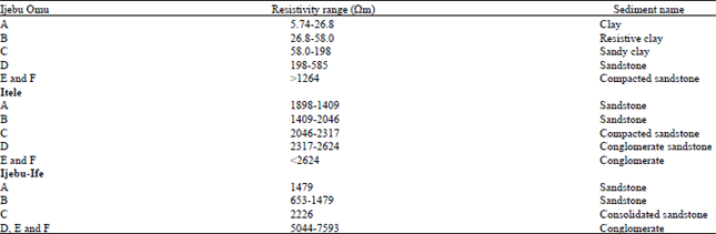
At Ijebu Omu, (Fig. 2a and b, Table 2), six (6) geo-electric layers were delineated which is comprised of clay, resistive clay, sandy clay, sandstone and compacted sandstone with resistivity values ranging from ~5.74-26.8, ~26.8-58.0, ~58.0-198, ~198-585 and~≥1264 Ωm, respectively. The thickness of the 2nd to 4th layer is ~3.9, 3.5-5.8, ~2.65-8.65 and ~2.5 -2.9 m. The sand layer formed a channel with thickness of ~25 m, height of ~9.52 m; the sandy bodies are thought to be deposited by meandering channels (Fig. 3a).
At Itele, three (3) geo-electric layers were identified comprising mainly of sandstone (layer A and B) with resistivity range of ~1898-2046 Ωm, compacted sandstone (layer C), ~2046-2317 Ωm with thickness of ~2.88-6.02 m and conglomerate (layer D and E), ~≥2317 Ωm having a thickness of ~3.75-1.25 m (Fig. 2a, b); these names were given based on the field observations. Structures identified include a clastic dyke with an average thickness of 8 m; the intrusion is composed of sandstone. Also two meandered channel sandstones were mapped from the pseudosection, their geometry include thicknesses of ~23 and ~27 m, heights of ~3.9 and ~3.7 m and aspect ratios of ~5.9 and ~7.30 m, respectively (Table 3).
The stratigraphy of Ijebu Ife include layers A and B with resistivity value of ~653-1479 Ωm, layers C, ~2226 Ωm and layers D, E and F with resistivity of ~5044-7593 Ωm (Fig. 2a, b). These rocks are described as Sandstone, Compacted Sandstone and conglomerate respectively. The channelized sand body (layer C) has thickness of ~39.5 m, height of ~12.4 m and aspect ratio of ~3.19 m; layer B occur as a sandstone lense sandwiched between layer A and C. The presence of ophiomorpha (Fig. 3c) in the uppermost layer at Ijebu-Ife suggest that the layer was deposited in a near shore environment; fractures were also observed in this rock, they may not be unconnected with burrowing of the sediments by the ophiomorpha because the fractures were seen closest to the trails of this ichnofossils.
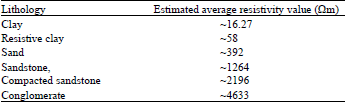
Overall, six (6) geo-electric facies were identified from the three locations; they include clay, resistive clay, sand, sandstone, compacted sandstone and conglomerate with average resistivity value of ~16.7, ~58, ~392, ~1264, ~2196 and ~4633 Ωm, respectively (Table 4).
The channels that cut across most of the outcrops studied are filled with debris flow deposits (B, C and D, all at Ijebu Omu).
| Table 2: | The resistivity and inferred lithology of the geo-electric layers in study area |
 | |
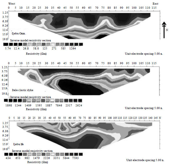 | |
| Fig. 2a: | Uninterpreted resistivity pseudosection of Ijebu-Omu, Itele and Ijebu-Ife |
These deposits vary in size from pebbles, boulders to sandstone; on the field they are characterized by highly disaggregated strata with no preservation of internal strata within a cohesive matrix.
| Table 3: | Calculated aspect ratios classifying and estimating the geometry of channels and clastic dykes of the study area |
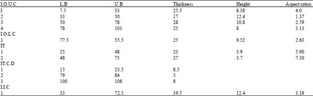 | |
| Key: I.O.U.C: Ijebu Omu upper channel; I.O.L.C: Ijebu Omu lower channel, IT: Itele, IT.C.D: Itele clastic dykes, I.I.C: Ijebu Ife channel | |
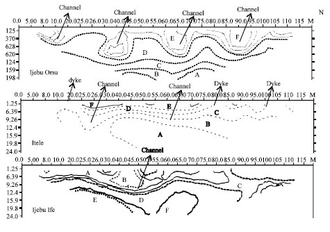 | |
| Fig. 2b: | Geological model of resistivity pseudosection of Ijebu-Omu, Itele and Ijebu-Ife |
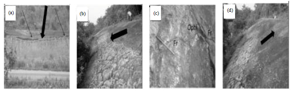 | |
| Fig. 3(a-d): | Photographs of (a) Channel infills at Ijebu Omu, (b) Ijebu Ife, respectively, (c) Ophiomorpha and fractures seen in the uppermost layer at Ijebu-ife and (d) Lithostratigraphy of Ijebu-Ife |
On the pseudosection and the field, the boulder sizes are thinning upward, a characteristic of slope channel sediments deposited by gravity (Fig. 2a, b).
The clastic dyke at Itele geometrically occur as vertical, inclined and irregular structures (Fig. 4a, b) that are infolded into the undeformed beds, occurring as intraformational folds (Fig. 4c, d). The composition of the undeformed host rock for the clastic dykes include Quartz and Iron oxide, the later is evinced by the reddish brown colour of the rock indicating oxidation of iron oxide.
| Table 4: | Inferred electrofacies of the area |
 | |
The intrusion of the dykes into the host rock causes fracturing of the rock in the vicinity of the dykes (Fig. 4f); elsewhere the dykes are fractured as a result of overburden pressure (Fig. 4d).
Evolutionary models: The geological and depositional history of the three locations are summarized below and schematically demonstrated in Fig. 6, the three dimensional perception of the slope structures are shown in Fig. 5a- f.
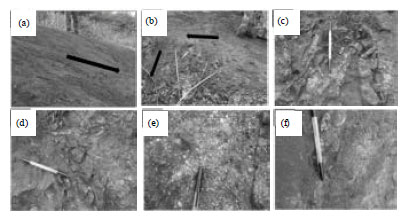 | |
| Fig. 4(a-f): | (a) The sandstone dyke intruding vertically from beneath into the surface, (b) The dykes are inclined at some places, (c, d) The dyke occur as folds between undeformed beds (intraformational folds)- the sandstone dykes are generally ferruginised, (e) Composition of the undeformed rock around the clastic dyke and (f) Micro tensional fractures associated with the dyke intrusion |
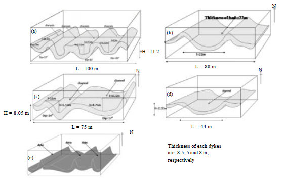 | |
| Fig. 5(a-e): | Depositional Model of the channels and clastic dykes of the study area, (a) Ijebu Omu outer meandering channels, (b) Ijebu Omu outer meandering channels, (c) Itele channel, (d) Ijebu Ife channels (model of sand body) and (e) Dimensional model of the clastic dyke intrusion at Itele |
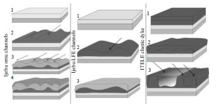 | |
| Fig. 6: | Evolutionary model for all the slope structures identified in the study area |
Ijebu Omu channels: Early sedimentation resulted in the deposition of clay, sand and Sandstone.
The deposition of the sandstone was possibly by a meandering channel, direction of flow is shown by the arrows. Subsequent sandstone was deposited also by channels, the sand body has variable thickness and the geometry of the channel courses is similar to that of braided channels.
These channels courses were later filled up with large debrites, the last sandstone were deposited in the accommodation space provided by the previous channel courses.
Ijebu Ife channels: Sedimentation of highly resistive conglomeratic sandstone by possibly a meander channel Subsequent infilling of channels by sandstones and last deposition in a near shore environment evidenced by the presence of ophiomorpha.
Itele clastic dyke: Deposition of conglomerate of different facies from pure conglomerate to conglomeratic sandstone.
Subsequent deposition of coarse grained unconsolidated sandstone.
Differential compaction and fluid expulsion as a result of newer sandstone deposition.
Pressure (probably fluid pressure) being exerted causes tensional stress and fracture which causes the underlying sediment to intrude the overburden along fracture planes.
Intrusion of clastic dykes as vertical or near-vertical structures, arrow points to the dykes occurring at the surface.
DISCUSSION
In the study area, the slope deposition and structures include channeling, sediments flow and clastic dyke intrusions. Slope-channeling in this area was predominantly characterized by erosional processes. Similar slope channel elements have been documented in the Upper Cretaceous Cerro Toro Formation and Miocene slope fan system in the Mt. Messenger Formation (Beabouef, 2004; Browne and Slatt, 2002). Channels are natural or artificial water course where stream flows towards an ocean, lake, sea or another channel. These streams contain sediments that are being deposited as velocity of movement wanes.
The sinuosity of a channel is a property that a stream may assume over all or parts of its course. The aspect ratio commonly known as sinuosity index or meander ratio is derived by dividing the thickness of the channel with its height. It is a means of quantifying how much a river or stream meanders (how much its course deviates from the shortest possible length). A perfectly straight river would have an aspect ratio of 1. The higher the ratio, the more the river meanders (the more its sinuosity). Thus in the area studied, we can say that sinuosity of the channels are very high due to their high aspect ratios.
The type of channels predominant in this area is the meandering channels; although it might have the properties of a braided channel in transverse view, the sinuosity of the channels as a function of the high aspect ratio makes it a meandering channel. Meandering channels forms where streams are flowing over a relatively flat landscape with a broad floodplain. They are characteristically u-shaped (Fig. 2b) or semi circular in cross section.
The channel forms that cut across the studied area are filled with debris deposits as seen in Fig. 2, understanding the geometry and behavior of this deposits is important for risk evaluation of their coastal and offshore counterparts. In addition, large and continuous boulders of ferruginous sandstone in Fig. 2a, b are similar to the anomalous coarse grained deposits of Aschoff and Giles (2005) recognized in the La Popa Basin, this deposit was interpreted as being of debris flow origin. Evidence for differential compaction during the early burial of these channels is implied by the presence of clastic dykes at Itele. The clastic dyke intrusions are thought to have resulted in response to overburden pressure. When this pressure reaches a critical value, the underlying unconsolidated sediments that are composed of alternating coarse grains rock breaks through the overlying layer, forming a dyke. This over pressuring can cause fracture or tensional stress within the affected lithology (Hiscott, 1979; Kimura et al., 1989) as shown in Fig. 3, 6.
As intraformational folds in the overlying rock, the dykes form isoclinal (Fairbridge, 1946) and recumbent fold. Intraformational folds are products of slump deformation, common in the slope environment (Fairbridge, 1946; Prothero and Schwab, 1996). The deformation caused by the dykes is syn-sedimentary, similar deformational styles have been described by Shanmugam et al. (1995), Cook et al. (1982), Ritchards (1998), Jackson (2007) and Olabode (2006).
The deduction drawn is as follows, that slope depositional process is predominant in this part of the Eastern Dahomey basin. These slope elements compare favorably with similar ones in other sedimentary basins around the world e.g., Clastic dykes described from Offshore Norway, North Sea basin by Jackson (2007), outcropping slope and deep-sea sedimentary features recognized by Selley (1985), Hiscott and Aksu (1994), Harrison and Graham (1999), Peter (2002), Browne and Slatt (2002), Beabouef (2004) and Shanmugam et al. (1995).
CONCLUSION
The sediments of the study area include mainly clay, sand, sandstone and conglomerate of variable resistivity values. Most of the sandstone bodies were deposited by meandering channels with different aspect ratios, while overburden pressure caused fluid expulsion, fracturing and subsequently injecting clastic dyke at Itele. The aspect ratios of the channels are greater than 1, high aspect ratios implied high sinuosity typical of meandering channels, other than this, the identified channels systems are generally erosive supporting the opinion that the debrites were translated over a basal shear surface.
ACKNOWLEDGMENTS
Department of Earth Sciences, Olabisi Onabanjo University, Department of Geophysics, University of Witwatersrand, South Africa for the RES2INV software. Adeshina Stanley, Adams Jelil, Osinowo Adetomiwa, Muyiwa Osho and Mrs. H.O. Omosanya for the proof read of the initial draft of the Manuscript.
REFERENCES
- Alfaro, P., J. Delgado, A. Estevez, J.M. Molina, M. Moretti and J.M. Soria, 2002. Liquefaction and fluidization structures in Messinian storm deposits (Bajo Segura Basin, Betic Cordillera, Southern Spain). Int. J. Earth Sci., 91: 505-513.
CrossRefDirect Link - Aschoff, J.L. and K.A. Giles, 2005. Salt diapir-influenced, shallow-marine sediment dispersal patterns: Insights from outcrop analogs. AAPG Bull., 89: 447-469.
Direct Link - Ajayi, T.R., A.A. Oyawale, F.Y. Islander, O.I. Asubiojo, D.E. Klein and A.I. Adediran, 2006. Trace and rare earth elements geochemistry of oshosun sediments of dahomey basin, Southwestern Nigeria. J. Applied Sci., 6: 2067-2076.
CrossRefDirect Link - Bachmann, G.H. and M.A.M. Aref, 2005. A seismite in Triassic gypsum deposits (Grabfeld Formation, Ladinian), Southwestern Germany. Sediment. Geol., 180: 75-89.
CrossRefDirect Link - Batayneh, A.T., A.S. Al-Zoubi and M.M. Abu-Ajamieh, 2004. Geoelectrical soundings and their relationship to channel seepage areas at the kaffrein dam, Jordan. J. Applied Sci., 4: 28-37.
CrossRefDirect Link - Beabouef, R.T., 2004. Deep-water leveed-channel complexes of the Cerro Toro formation, Upper Cretaceous, Southern Chile. AAPG Bull., 88: 1471-1500.
CrossRefDirect Link - Boadu, F.K., J. Gyamfi and E. Owusu, 2005. Determining subsurface fracture characteristics from azimuthal resistivity surveys: A case study at Nsawam, Ghana. Geophysics, 70: B35-B42.
CrossRefDirect Link - Browne, G.H. and R.M. Slatt, 2002. Outcrop and behind-outcrop characterization of a late miocene slope fan system, Mt. Messenger formation, New Zealand. AAPG Bull., 86: 841-862.
CrossRefDirect Link - Burke, K.C.B., T.F.J. Dessauvagie and A.J. Whiteman, 1971. Opening of the gulf of guinea and geological history of the Benue Depression and Niger Delta. Nat. Phys. Sci., 233: 51-55.
Direct Link - Ribeiro, C. and P. Terrinha, 2007. Formation, deformation and chertification of systematic clastic dykes in a differentially lithified carbonate multilayer. SW Iberia, Algarve Basin, Lower Jurassic. Sediment. Geol., 196: 201-215.
CrossRefDirect Link - Dahlin, T. and M.H. Loke, 1998. Resolution of 2D Wenner resistivity imaging as assessed by numerical modelling. J. Applied Geophys., 38: 237-249.
CrossRefDirect Link - DeGroot-Hedlin, C. and S. Constable, 1990. Occam's inversion to generate smooth two dimensional models from magnetotelluric data. Geophysics, 55: 1613-1624.
CrossRefDirect Link - Ehirim, C.N. and W. Ofor, 2011. Assessing aquifer vulnerability to contaminants near solid waste landfill sites in a coastal environment, Port Harcourt, Nigeria. Trends Applied Sci. Res., 6: 165-173.
CrossRefDirect Link - Elueze, A.A. and M.E. Nton, 2004. Organic geochemical appraisal of limestones and shales in part of Eastern Dahomey basin, Southwestern Nigeria. J. Mining Geol., 40: 29-40.
Direct Link - Enu, E.I., 1985. Textural characteristics of the Nigerian tar sands. Sediment. Geol., 44: 65-81.
CrossRefDirect Link - Fairbridge, R.W., 1946. Submarine slumping and location of oil bodies. AAPG Bull., 30: 84-92.
CrossRef - Leucci, G., 2006. Integrated geophysical, geological and geomorphological surveys to study the coastal erosion. Int. J. Soil Sci., 1: 146-167.
CrossRefDirect Link - Griffiths, D.H. and R.D. Barker, 1993. Two-dimensional resistivity imaging and modelling in areas of complex geology. J. Applied Geophys., 29: 211-226.
CrossRefDirect Link - Harrison, C.P. and S.A. Graham, 1999. Upper Miocene Stevens Sandstone, San Joaquin Basin, California: Reinterpretation of a petroliferous, sand-rich, deep-sea depositional system. AAPG Bull., 83: 898-924.
Direct Link - Al-Hagrey, S.A., 1994. Electric study of fracture anisotropy at Falkenberg, Germany. Geophysics, 59: 881-888.
CrossRefDirect Link - Higgs, R., 2004. Ross and Bude formations (carboniferous, Ireland and England): Reinterpreted as Lake-shelf turbidites. J. Pet. Geol., 27: 47-66.
CrossRefDirect Link - Hiscott, R.N., 1979. Clastic sills and dikes associated with deep-water sandstones, Tourelle Formation, Ordovician, Quebec. J. Sediment. Petrol., 49: 1-9.
CrossRefDirect Link - Hiscott, R.N. and A.E. Aksu, 1994. Submarine debris flows and continental slope evolution in front of quaternary ice sheets, Baffin Bay, Canadian Arctic. AAPG Bull., 78: 445-460.
CrossRefDirect Link - Jackson, C.A.L., 2007. Application of three-dimensional seismic data to documenting the scale, geometry and distribution of soft-sediment features in sedimentary basins: An example from the Lomre Terrace, offshore Norway. Geol. Soc. London Special Publ., 277: 253-267.
CrossRefDirect Link - Jones, A.P. and K. Omoto, 2000. Towards establishing criteria for identifying trigger mechanisms for soft-sediment deformation: A case study of Late Pleistocene lacustrine sands and clays, Onikobe and Nakayamadaira basins, northeastern Japan. Sedimentology, 47: 1211-1226.
CrossRefDirect Link - Kimura, G., K. Koga and K. Fujioka, 1989. Deformed soft sediments at the junction between the Mariana and Yap Trenches. J. Struct. Geol., 11: 463-472.
CrossRefDirect Link - Loke, M.H. and R.D. Barker, 1996. Rapid least-squares inversion of apparent resistivity pseudosections by a quasi-Newton method. Geophys. Prospect., 44: 131-152.
CrossRefDirect Link - Majumdar, R.K. and D. Das, 2011. Hydrological characterization and estimation of aquifer properties from electrical sounding data in sagar island region, South 24 Parganas, West Bengal, India. Asian J. Earth Sci., 4: 60-74.
CrossRefDirect Link - Matsuda, J.I., 2000. Seismic deformation structures of the post-2300 a BP muddy sediments in Kawachi lowland plain, Osaka, Japan. Sediment. Geol., 135: 99-116.
CrossRefDirect Link - McLaughlin, P.I. and C.E. Brett, 2004. Eustatic and tectonic control on the distribution of marine seismites: Examples from the Upper Ordovician of Kentucky, USA. Sediment. Geol., 168: 165-192.
CrossRefDirect Link - Molindo, W.A. and O.M. Alile, 2007. Evaluation of the thermal conductivity of soils in edo state, Nigeria. J. Applied Sci., 7: 519-522.
CrossRefDirect Link - Molina, J.M., P.A. Ruiz-Ortiz and J.A. Vera, 1997. Calcareous tempestites in pelagic facies (Jurassic, Betic Cordilleras, Southern Spain). Sediment. Geol., 109: 95-110.
CrossRefDirect Link - Nwankwo, L.I., 2011. 2D resistivity survey for groundwater exploration in a hard rock terrain: A case study of MAGDAS observatory, UNILORIN, Nigeria. Asian J. Earth Sci., 4: 46-53.
CrossRefDirect Link - Ojeda, H.A.O., 1982. Structural framework, stratigraphy and evolution of Brazilian Basins. AAPG Bull., 66: 732-749.
CrossRefDirect Link - Olabode, S.O., 2006. Siliciclastic slope deposits from the Cretaceous Abeokuta Group, Dahomey (Benin) Basin, Southwestern Nigeria. J. Afr. Earth Sci., 46: 187-200.
CrossRefDirect Link - Peter, D., 2002. Depositional processes and sequence stratigraphic interpretation of cretaceous carbonate slope deposits, South-Central Pyrenees, Spain. Proceedings of the AAPG Annual Meeting, March 10-13, 2002, Houston, Texas, pp: 1-9.
Direct Link - Rossetti, D.F. and A.E. Santos Jr., 2003. Events of sediment deformation and mass failure in Upper Cretaceous estuarine deposits (Cameta Basin, northern Brazil) as evidence for seismic activity. Sediment. Geol., 161: 107-130.
CrossRefDirect Link - Sasaki, Y., 1992. Resolution of resistivity tomography inferred from numerical simulation. Geophys. Prospect., 40: 453-463.
CrossRefDirect Link - Shanmugam, G., R.B. Bloch, S.M. Mitchell, G.W.J. Beamish and R.J. Hodgkinson et al., 1995. Basin-floor fans in the North Sea: Sequence stratigraphic models vs. sedimentary facies. AAPG Bull., 79: 477-512.
CrossRefDirect Link - Sirhan, A., M. Hamidi and P. Andrieux, 2011. Electrical resistivity tomography, an assessment tool for water resource: Case study of Al-Aroub Basin, West Bank, Palestine. Asian J. Earth Sci., 4: 38-45.
CrossRefDirect Link - Skjernaa, L. and N.O. Jorgensen, 1993. Evaluation of local fracture systems by azimuthal resistivity surveys: Examples from South Norway. Hydrogeol. J., 2: 19-25.
CrossRefDirect Link - Storey, B.C., 1995. The role of mantle plumes in continental breakup: Case histories from Gondwanaland. Nature, 377: 301-308.
CrossRefDirect Link - Ekinci, Y.L., A. Demirci and C. Ertekin, 2008. Delineation of the seawater-freshwater interface from the coastal alluvium of Kalekoy-Gokceada, NW Turkey. J. Applied Sci., 8: 1977-1981.
CrossRefDirect Link