
X. Li
Department of Computer System and Technology, Faculty of Computer Science and Information Technology, University of Malay, 50603, Kuala Lumpur, Malaysia
R. Salleh
Department of Computer System and Technology, Faculty of Computer Science and Information Technology, University of Malay, 50603, Kuala Lumpur, Malaysia
O. Zakaria
Department of Computer System and Technology, Faculty of Computer Science and Information Technology, University of Malay, 50603, Kuala Lumpur, Malaysia
Journal of Applied Sciences
Year: 2009 | Volume: 9 | Issue: 2 | Page No.: 304-311


ABSTRACT
In this study, we focus on combination of GIS and 5G wireless mobile multimedia networks to propose a real-time fire disaster processing model-Mobile Multimedia Control Model (MMCM) so that a quick response can be taken once fires over to reduce destroy, especially peoples life. In the end of the study, two models will be compared.
PDF Abstract XML References Citation
How to cite this article
X. Li, R. Salleh and O. Zakaria, 2009. Mobile Multimedia Control Model for Fire Disaster of City Building. Journal of Applied Sciences, 9: 304-311.
DOI: 10.3923/jas.2009.304.311
URL: https://scialert.net/abstract/?doi=jas.2009.304.311
DOI: 10.3923/jas.2009.304.311
URL: https://scialert.net/abstract/?doi=jas.2009.304.311
INTRODUCTION
Fire disaster management models have been experienced two generations. The first generation is the fire disaster monitored by man. In the model, the responses depend on man activity. Obviously, that has to delay a long time. The second generation is the computer networks and satellites to aid monitoring, which needs certain system based on city map, such as Geographic Information System (GIS). The problem in the GIS system is city map. The city construction always be updated following the economic development, but the city map can not do like this. Future, fire disaster can be monitored in real-time by mobile multimedia networks based on 5G real wireless networks.
Wireless networks have been successful in their commercial area (Abdullah et al., 2008). Today, wherever we are, such as airport, coffee bar, office, even at house we are with family, the supplements of internet information service through wireless networks are ready. The new technology has changed our life style and idea as well. The changing directly drives new risk management model. In this study, a new fire disaster control model based on the new technology, 5G real wireless world, will be proposed.
Traditional fire disaster management system is based on information transferred by human (Yassemi et al., 2008). Once fire disaster appears in a building, the resident will call fire fighter at the first time. After the fire fighters get the information, they come out from office and try to find where the place is. During this proceeding, the caller and the fighter has to keep contact by the call. The contacts always lost and delay to arrive in the location because of rare direction information.
Geographic information system is based on data information of city map which try to guide the fire fighter for reducing delay time (Johnson, 2000). This is a way to supply reference to fighter so that they can find the fired location in time. But the problem for the control model is the reliable of the map. It means that the map must be trusted; otherwise, an indirection error will delay the activity. Actually, city building development is so fast. After one year or two years, many changes occur in any city. It is impossible to update the map following city construction. Therefore, a new fire disaster control model based on new wireless technology is needed. This new model is what we called mobile multimedia control model for fire disaster of city building.
The mobile multimedia control model for fire disaster is based on real-time and visible environment (Salleh et al., 2008). Sensor networks supply a detection in real-time and mobile multimedia networks supply visible guideline for fighter in real-time as well. Obviously, mobile multimedia networks make a key role in the new control model. This is a new challenge for future risk management of fire disaster.
The challenge will be solved future by new technologies. The next generation wireless mobile multimedia internet networks integrate with current existing cellular networks, Wi-Fi networks and fixed internet networks to supply mobile multimedia applications for customers. Both of capacities and data rates are significant enhancement, mobile multimedia control model for fire disaster will be possible in this case (Li et al., 2007).
In mobile multimedia control model, multimedia networks are a real-time wireless system. Sensor devices are equipped in any building. Once fire disaster occurs, sensor networks detect and transfer the detection results to Mobile Multimedia Control Center (MMCC). Each fire fighter has a mobile device which connects with MMCC. In this case, everybody of fire fighter is a monitor by 24 h day-1. This can prevent the first time delay by information exchanges between resident and fire fighter.
On the other hand, the fire fighters guide by mobile multimedia device, which the local environment can be visible. Where the fire scene is and how they can arrive, all of this information will be shown in mobile device by the mobile multimedia networks through MMCC. During on the fire scene way, the fire fighter can guide resident to make emergent activity by the mobile multimedia. Therefore, for fire fighters, the time can be saved not only on the way of fire scene, but also in making emergent activity. Lost can be reduced in whole processing.
MATERIALS AND METHODS
Multimedia control mode for fire disaster of city building is based on mobile multimedia internet network and Geographic Information System (GIS) model.
MOBIL MULTIMEDIA INTERNET WORKS
Nowadays, wireless technology is getting popular and important in the mobile telephone network and the Internet field which have altered the industry and people`s life (Ruscelli and Cecchetti, 2008).
Actually, in their beginnings of usage, Internet and mobile telephone were primarily limited to academic and scientific institutions because of high costs. Today, the widespread use of the Internet for communications, file transfer and World Wide Web connectivity is commonplace for most business and home users. Just as there has been an unstoppable growth in the Internet, the number of mobile telephones has similarly advanced at an amazing pace.
Mobile networks have experienced three generations of its life (Rissen, 2008). The first generation is an analog system which is to be used for public with voice service only; the second generation is based on digital technology, which can support text messaging. Its success and the growth of demand for online information via the Internet prompted the development of mobile wireless systems with improved data connectivity, which ultimately lead to the latest third Generation (3G) systems. For third generation networks, although the coverage and the quality of the service both have increased dramatically, but as it was not within the original scope of the design of mobile networks, indoor coverage and data capacity are still significantly limited. WLAN systems were designed for indoor, data traffic has demonstrated their ability support the needs of limited mobility indoor clients. For these reasons, many supported the eventual convergence of the two communications networks to provide better services such as larger capacities and higher data rates and improve coverage for their users (Chen and Yang, 2007). The standards developing bodies attempted to define standards for the interoperation of the two systems and several researchers thought to determine the best methods to interwork the two systems (3GPP2, 2006).
As the mobile telephone and Internet proliferate, researchers and service providers have attempted to integrate them (Fig. 1). These attempts to integrate data services into mobile networks have brought the limitations of both the Internet and the mobile network into sharp focus. The Internet`s best effort model is limited in its ability to support the real time constraints of a voice conversation. While, the mobile telephone network`s low data rate is not sufficient for web browsing or large file transfers. Ongoing research is aimed at improving Quality of Service (QoS) for the Internet and increasing data rates on mobile networks.
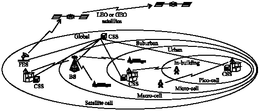 | |
| Fig. 1: | Future Network |
The 3rd Generation (3G) wireless mobile internet networks have get ready to live up to its performance in computer networking and mobile device area, which is limited access voice quality and up to 2M bit/sec for data rates (Al-Shawabkeh et al., 2007). The 4th Generation (4G) wireless mobile internet networks combine current existing 3G cellular networks and Wi-Fi networks with fixed internet to support wireless mobile internet as the same quality of service as fixed internet, which is an evolution not only to move beyond the limitations and problems of 3G, but also to enhance the quality of services, to increase the bandwidth and to reduce the cost of the resource. The 5th wireless mobile internet networks are completed wireless communication without limitation.
GIS MODEL
Geographic information system model is used for fire disaster of city building or risk management which can be given response in short time over emergency. A map database of city has been established, the risk`s response such as fire fighter can follow the map database guideline to find the emergent scene in time. Tong et al. (2007) defined, implemented and measured the GIS system which includes five steps: planning, mitigation, preparedness, response and recovery. The GIS model is presented in Fig. 2.
Planning: In this step, everybody and everywhere should include. The government makes regulation, the fighter takes action and the residents learn how to prevent emergency. Activities necessary to be analyzed and documented the possibility of an emergency or disaster and the potential consequences or impacts on life, property and the environment. This includes assessing the hazards, risks, mitigation, preparedness, response and recovery needs.
Mitigation: In this step, the fire fighter is in charge of activities that actually eliminate or reduce the probability of a disaster (for example, arms buildup to deter enemy attack, or legislation that requires stringent building codes in earthquake prone areas). It also includes long-term activities designed to reduce the effects of unavoidable disaster (for example, land use management, establishing comprehensive emergency management programs such as vegetation clearance in high fire dangerous areas, or building restrictions in potential flood zones).
Preparedness: In this step, a plan should make. Activities necessary to the extent that mitigation measures have not, or cannot, prevent disasters. In the preparedness phase, governments, organizations and individuals develop plans to save lives and minimize disaster damage (for example, compiling state resource inventories, mounting training exercises, installing early warning systems and preparing predetermined emergency response forces). Preparedness measures also seek to enhance disaster response operations (for example, by stockpiling vital food and medical supplies, through training exercises and by mobilizing emergency response personnel on standby).
Response: In this step, each body should make responses at first time. It means that activities following an emergency or disaster.
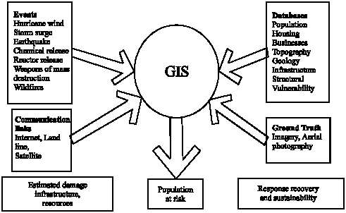 | |
| Fig. 2: | GIS for Disaster management and terrorism (Jonson, 2000) |
These activities are designed to provide emergency assistance for victims (for example, search and rescue, emergency shelter, medical care and mass feeding). They also seek to stabilize the situation and reduce the probability of secondary damage (for example, shutting off contaminated water supply sources and securing and patrolling areas prone to looting) and to speed recovery operations (for example, damage assessment).
Recovery: In this step, the government makes a key role. Activities necessary are to return all systems. They include two sets of activities:
| • | Short-term recovery activities return vital life-support systems to minimum operating standards (for example, cleanup, temporary housing and access to food and water); and |
| • | Long-term recovery activities may continue for a number of years after a disaster. Their purpose is to return life to normal or improved levels (for example, redevelopment loans, legal assistance and community planning). |
MOBILE MULTIMEDIA CONTROL MODEL DESIGN FOR FIRE DISASTER
We combine the next generation mobile multimedia internet networks and geographic information system model to propose mobile multimedia control model. In this section, we present mobile multimedia control model design, implementation and measurement.
Mobile multimedia control model design: Mobile multimedia control model design is based on the three ideas as follows:
| • | Mobile Multimedia Control Center (MMCC): Mobile multimedia control model has to be supported by mobile multimedia internet networks. Once the new technology is living up for utilization, mobile multimedia can be used for risk management. In other words, the new technology drives the new risk management model |
| • | Geographic information system (GIS): GIS has defined a new model which accepted by industry and discussed by academic researchers. It is not necessary for mobile multimedia control model to follow GIS model, but the model can be reference architecture for mobile multimedia control model; and |
| • | Real-time activity: GIS model gives a common understanding of a specific domain by defining its elements and the relationships between these elements. We think that the rigorous and formalized mobile multimedia control model approach is one key word - real-time. |
Therefore, mobile Multimedia Control Model (MMC) is not either a description of a complex social system itself with all its actors, relations and processes, nor it describes the logic of a risk management system for creating value, that lies behind the actual processes. Even we haven`t understood a MMC model as the conceptual and architectural implementation of a risk management strategy and as the foundation for the implementation of risk management processes. Obviously, in our research, the population of risk is a key component in MMC model and response activity is taken there. The city data is managed by MMCC. Once fire disaster occurs, MMCC sends alarm to individual, fighter and government at first time. The individual can run away from the fire scene at once and the fighter and government can take response at once as well. For both fighter and government, what they can do over fire at first time is to move to the fire scene by the shortest time (Fig. 3).
Mobile multimedia control model implementation: The primary goal of mobile multimedia control model is preserving life; life safety with no permanent damage to health. Thus, buildings must be designed for the event of fire; the residents can remain in place safely, evacuate to another part of the building where it is relatively safe or totally evacuate the building without exposed to unhealthy, hazardous or untenable conditions. Actually, all of the facilities may be damaged over fire, the fire fighter and government assistant should make a key role. Therefore, we propose mobile multimedia control model which focuses on the residents` life safety. However, population of risk is a key component in the mobile multimedia control model. Furthermore, activity is the main processing in the model. The detailed implementations are presented as follows.
City information: The GIS model is based on city map database which is not reliable. The mobile multimedia control model is based on sensor and visible environment which supply a real-time case. The requirement of the case is first time detection and first time sends detection result to MMCC so that the response can be taken at first time by the fire fighter and government. In other words, the city information should be controlled by all of other components in the model. Therefore, the city information is a basis in the mobile multimedia control model.
However, in the model, city information will be always controlled by other components.
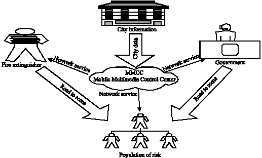 | |
| Fig. 3: | Mobile multimedia control model |
Sensor device can be equipped anywhere and sensor network can detect anywhere and send results to MMCC. The mobile multimedia network can make anywhere visible at real-time.
Government: The government is a role of assistant in the model, even it is important. Normally, the government making role is to do assistant including financial support, food support, water support, health support and communication over fire case.
Actually, the government key role should be taken before fire disaster happens, such as planning and preparedness. The important activities are trading for both fire fighter and resident. The resident should know how to make life safety at emergency and the fire fighter should be very familiar about the processing of aid, especially for resident of emergency. Thus, the damage will be reduced.
Therefore, the role of government in the model can be summarized in two-fold: the first is to make detailed plan and careful preparedness before fire disaster happens. The second is to supply assistant over fire disaster, especially to settle down those people who are damaged.
The fire fighter: The key role is fire fighter in the model. The damage reduced depends on the fire fighter who related with how fast they can arrive the fire scene and what kind of efficient activities can be taken over fire.
In the mobile multimedia control model, MMCC can supply a visible and real-time guideline for fire fighter. Each fire fighter has a mobile device which can show all of the city information including building, road and population through Mobile Multimedia Control Center (MMCC). Once fire disaster happens in somewhere, the sensor detects and sends the result to MMCC which then transfer the result to mobile device. In this case, fire fighter is monitoring everywhere by 24 h day-1 through mobile device.
Once fire disaster is monitored and detected by fire fighter, the following activity is to arrive in fire scene at the first time. This phase is so important for fire disaster, because the shortest time drives the damage reduced directly. The idea of MMCC is designed for this perspective. The MMCC can supply visible guideline for fire fighters to make sure that they can arrive in fire scene at first time. The visible guideline is to supply guaranteed information such as which road directs there and where traffic jam is. This is to supply guaranteed services for fire fighter. It means that this is the best solution.
Since the MMCC supplies the real-time monitor and visible guideline for fire fighter that can make response at first time, the damage of fire disaster can be reduced much more in the mobile multimedia control model, especially for people life.
The population of risk: The most important component in the mobile multimedia control model is the population of risk. In Fig. 3, city information is added into the MMCC, which can supply real-time services to the fire fighter and government who can take activity for the population of risk over fire. Actually, all of other components are working for the population of risk component.
The original idea of the mobile multimedia control model design is based on the life safety and the damage reduces. Obviously, the government is a leader in the model. The necessary activities should be taken by government are plan and preparedness before fire disaster occurs. Of course, the plan and the preparedness are focused on life safety and damage reduces. Therefore, the fire fighter is key component in the model. Since the life safety and damage reduce depend on the fire fighter and their activities.
Once all of these components work efficiently, such as the city information will be supply in real-time by the MMCC, the government makes useful plan and nice preparedness and the fire fighter has significant response, the life safety and damage reduce can be coming true.
MOBILE MULTIMEDIA CONTROL MODEL MEASUREMENT
The next generation mobile multimedia network is a research item in academy. 5G have not defined yet. Therefore, it is impossible to measure mobile multimedia control model based on current existing wireless networks. In this section we compare the Geographic Information System (GIS) and mobile multimedia control model to get a comparison result. Five phases of GIS are compared which including planning, mitigation, preparedness, response and recovery as follow.
Planning: In GIS model, emergency management programs begin with locating and identifying potential fire disaster problems and then government evaluates the consequences of potential fire disaster. Since GIS model is based on map database, what the government can do is to point the fire disaster potential area. After this, the government can begin to formulate mitigation, preparedness, response and possible recovery.
In mobile multimedia control model, the MMCC supply city information based on visible and real-time, all of city environment are shown in mobile device which are used for monitor anywhere. This difference drives the following activities taken by the government: mitigation, preparedness, response and recovery.
Mitigation: In GIS model, once fire disaster is identified as emergency case, mitigation needs can be determined and prioritized. In the case of fire disaster, what developments are within the primary impact? What damage may occur? Where are the fire disaster zones? What combination of features (for example, topography, vegetation and weather) constitutes a fire disaster? A GIS can identify specific slope categories in combination with certain specifies of flammable vegetation near homes that could be threatened by wildfire. More importantly, human life and other values (property, habitat, wildlife, etc.) at risk from these emergencies can be quickly identified and targeted for protective action.
In mobile multimedia control model, all of city building and house are monitored in real time. What damage may occur and where the fire disaster zones are visible. Thus, expected and controlled activity can be taken by both government and fire fighter.
Preparedness: In GIS model, preparedness includes those activities that prepare for actual fire disaster. GIS can provide answers to questions such as Where should fire stations be located if a five-minute response time is expected? How many paramedic units are required and where should they be located? What evacuation routes should be selected if a toxic cloud or plume is accidentally released from a plant or storage facility based on different wind patterns? How will people be notified? Will the road networks handle the traffic? What facilities will provide evacuation shelters? What quantity of supplies, bed space and so forth, will be required at each shelter based on the number of expected evacuees?
From the GIS model, it seems that GIS is so nice and useful to manage emergencies. Actually, the city development is so fast and the city environment is always changing. Most preparedness is useless over fire. That is why the time always delays in any experience of fire disaster.
In mobile multimedia control model, fire disaster scene is monitored and visible by everybody, even by resident, government and fire fighter. The preparedness is to trade resident and fire fighter making response in first time over fire.
Response: In GIS model, GIS can provide one of the primary components for computer-aided dispatch (CAD) systems. Fire disaster response units based at fixed locations can be selected and routed for the emergency response. The closest (quickest) response units can be selected, routed and dispatched to an fire disaster once the location is known. Depending on the emergency, a GIS can provide detailed information before the first units arrive. For example, during a commercial building fire, it is possible to identify the closest hydrants, electrical panels, hazardous materials and floor plan of the building while en route to the emergency.
The GIS system can run very well in computer networks. But in reality, something always has been changed. For example, during a commercial building fire, it is possible to identify the closest hydrants. Actually, in computer networks system of GIS, it is so easy to do. In reality, who can identify the closest hydrants? Where are the closest hydrants? How to use the closest hydrants? All of these questions do not have answer.
In mobile multimedia control model, the environment of the fire disaster is visible and the information exchange is in real-time. Where is the fire disaster? It is visible by everybody through its mobile device. Where is the closest hydrant over fire? It is visible by every body through its mobile device. Thus, the response can be taken by everybody in the case, not only from fire fighter and government. First time getting the information of fire disaster and fist time taking response, this can supply more efficient recovery for the fire disaster.
Recovery: In GIS model, recovery efforts begin when fire disaster is over. GIS can play an important role in the recovery efforts. One of the most difficult jobs in a fire disaster is damage assessment. A GIS can work in concert with GPS to locate each damaged facility, identify the type and amount of damage and begin to establish priorities for action (triage). Laptop computers can update the primary database from remote locations through a variety of methods. GIS can display (through the primary database) overall current damage assessment as it is conducted. A GIS can display areas where services have been restored in order to quickly reallocate recovery work to priority tasks. Action plans with maps can be printed, outlining work for each specific area.
On the other hand, the immediate recovery efforts can be visually displayed and quickly updated until recovery is complete. This visual status map can be accessed and viewed from remote locations. This is particularly helpful for the fire disasters where work is ongoing in different locations.
The problem is that the GIS database should be updated quickly so that the recovery efforts can be visually displayed. How can this become reality? Actually, that needs a long time to deal with. Once the treatment is completed in somewhere, this effort should be informed to information center. The staff in information center updates the related database after received the effort information. And then, this information can be visually displayed. Thus, the visually displayed information can be used to guide new activity. This is a long-term processing for emergency aid.
In mobile multimedia control model, where the recovery efforts has been completed and where the recovery are still waiting for, all of these requirements are visible in real-time through mobile device which supply by MMCC.
From the comparison of Geographic Information System (GIS) and Mobile Multimedia Control Model (MMCM) above, we can see that the response time is a key factor for the fire disaster. We have compared the GIS time delay and MMCM time delay as presented in Fig. 4.
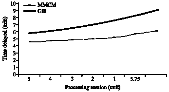 | |
| Fig. 4: | GIS and MMCM comparison |
In Fig. 4, the comparison shows that GIS time delay is quite much than MMCM. At the earlier of the fire disaster, many sessions should be taken, such as the MMCC supplies detection information to individual, fire fighter and government. Once all of them received fire disaster information, the individual of resident leaves from the scene quickly, the fire fighter gets out from office and goes to the fire scene, the government gets start risk management steps. The fire fighter needs to take time to arrive in the fire scene. All of these sessions are taken at earlier of fire disaster over. The time delay is necessary.
The difference between the GIS and MMCM is that how many minutes delayed. In Fig. 4, GIS delay is increasing with processing session decreasing. This is because that GIS guideline is on map, both of the fire fighter and government have to transfer map information into city real environment and then the necessary activities can be taken. The problems from this processing are that the city real environment is not always match with the map information because of fast development. Therefore, the processing session is decreasing, but time delay is still increasing for GIS.
CONCLUSION
In this study, the mobile multimedia control model is developed and implemented through the analysis of information. The majority of information is visible and real-time. Once city information is visible and real-time controlled by the MMCC, emergency management planning can begin. Once life, property and environmental values are combined with fire disaster, the government can begin to formulate mitigation, preparedness, response and recovery program needs. In the mobile multimedia control model, the fire fighter makes a key role and the government component is an assistant and policy maker. All of these activities are focused on population of risk.
We have compared the current existing GIS and the Mobile Multimedia Control Model (MMCM) through each step of activities taken. The MMCM is much better than GIS. Future, the MMCM can be extended into emergency management system which can deal with an incident, disaster events such as wildfires, tsunami, floods, earthquakes, hurricanes, epidemics, chemical cloud dispersion and oil spills.
REFERENCES
- Yassemi, S., S. Dragicevic and M. Schmidt, 2008. Design and implementation of an integrated GIS-based cellular automata model to characterize forest fire behavior. J. Ecol. Model., 210: 71-84.
Direct Link - Al-Shawabkeh, M., R. Salleh and X. Li, 2007. Bandwidth optimization control protocol for 4G wireless mobile internet. Proceedings of the 11th WSEAS International Conference on Communications, July 23-25, 2007, Agios Nikolaos, Greece, pp: 279-284.
Direct Link - Chen, Y. and Y. Yang, 2007. A new 4G architecture providing multimode terminals always best connected services. IEEE Wireless Commun., 14: 36-41.
Direct Link - Rissen, J.P., 2008. Mapping the wireless technology migration path: The evolution to 4G systems. Enriching Commun., 2: 73-79.
Direct Link - Ruscelli, A.L. and G. Cecchetti, 2008. Toward the QoS support in 4G wireless systems. Proceeding of the 18th Tyrrhenian Workshop on Digital Communications, Septmber 18-22, 2007, Italy, pp: 245-252.
Direct Link - Li, X. and R. Salleh, 2007. Handoff techniques for 4G wireless mobile internet. Inform. Technol. J., 6: 745-750.
CrossRef