
Emmanuel Olubayo Oghre
Department of Mathematics, University of Benin, Benin City, Nigeria
Edward Ohifeme Ifidon
Department of Mathematics, University of Benin, Benin City, Nigeria
Journal of Applied Sciences
Year: 2005 | Volume: 5 | Issue: 5 | Page No.: 829-833


ABSTRACT
We derived the lunar tide generating force of 1.47 x 10⁻⁷ N per unit mass of water causing tidal oscillation in the Escravos Bar. The geostrophic force which is the combined effect of the coriolis force due to the rotation of the earth and the tide generating forces produce the degeneration of nodal lines to a single point, the amphidromic point round which tidal oscillation appears to rotate in a counter clockwise direction. However due to the length of the gulf, the amphidromic point does not exist within the Bar.
PDF Abstract XML References Citation
How to cite this article
Emmanuel Olubayo Oghre and Edward Ohifeme Ifidon, 2005. Geostrophic Effect on Tidal Co-oscillation in the Escravos Bar, Warri. Journal of Applied Sciences, 5: 829-833.
DOI: 10.3923/jas.2005.829.833
URL: https://scialert.net/abstract/?doi=jas.2005.829.833
DOI: 10.3923/jas.2005.829.833
URL: https://scialert.net/abstract/?doi=jas.2005.829.833
INTRODUCTION
Nigeria is bounded in the South by a large expanse of the Atlantic Sea and there are many estuaries to the sea. One of these estuaries is the Escravos River. The Escravos Bar, Warri is an inlet of the Sea water into the Coastland to form a Gulf.
There are two classes of force acting on any particular body of sea water. These are internal forces (the pressure of the sea, the force of internal friction) and the external forces (weight of the water itself, the pressure of the sea bottom and of the shore, frictional forces arising at the bottom and at the shore, the pressure of the atmosphere, the frictional drag from the wind and tide generating forces due to the moon and the sun). The external forces, which initiate and maintain motion in the sea are the frictional drag of the wind on the sea surface the changes in atmospheric pressure tide generating forces of the moon and the sun (also the external thermodynamic action may set up internal pressure changes)
Any body in or near the earth is subject to the force of the earth gravity and in studying the motion of such body, the effect of the rotation of the earth must be taken into consideration. The greater part of the total force of gravity near the earth surface is due to the matter of the earth itself, but a small part is due to the matter of the sun and the moon. The variation of this part constitutes tide generating forces. Tide is the regular rise and fall in the level of the sea surface and it is caused by the attraction of the moon and the sun on the mass of water.
MATHEMATICAL FORMULATION
The Newton’s gravitational law gives the force of attraction exerted by one particle over another and it is exerted along the straight line joining the centres of the two particles. This implies that the gravitational force on the solid earth due to the moon is equal to the force on a point mass (equal to the mass of the earth) and situated at the centre of the earth. The tide generating force due to the moon on a small mass of water is obtained from the excess of the gravitational force of the moon on this water in its actual position over the gravitational attraction on an equal mass situated at the earth’s centre.
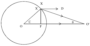
In Fig. 1, O and O’ are the centres of the Earth and the moon respectively, X is a point on the great circle in which the plane through OO’ cuts the surface of the earth. Let r be the distance of the moon from the earth i.e. OO’ = r, e is the radius of the earth and x the distance of X from the moon, C is the angle XOO’ which is the longitude of the point at which the mass of water is situated. E is the mass of the earth, M the mass of the moon, m the mass of the water at X and g the coefficient of the gravitational force.
The attractive force exerted by the earth on a particle of mass m at the point X is mg. The attractive force F’ of the moon on this same particle is
The attractive force between the particle and the Earth is ![]()
where, γ is the gravitational constant and e is the radius of the earth.
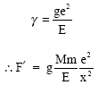 |
The attractive force of the moon on an equal mass at the centre of the earth is ![]() If every particle of the earth experiences exactly the same lunar attractive force both in magnitude and direction, there would be no forces causing relative movement on the earth’s surface. It is the variations in the attractive force which cause one particle to move relative to the other. The tide generating force at a point X is therefore defined as the difference in the attractive force experienced at the centre of the earth[1]. Thus the differential force on m at the point X is the vector sum of
If every particle of the earth experiences exactly the same lunar attractive force both in magnitude and direction, there would be no forces causing relative movement on the earth’s surface. It is the variations in the attractive force which cause one particle to move relative to the other. The tide generating force at a point X is therefore defined as the difference in the attractive force experienced at the centre of the earth[1]. Thus the differential force on m at the point X is the vector sum of ![]() along XO’ and
along XO’ and ![]() along OO’.
along OO’.
The force F’ along XO’ can be resolved horizontally along XD and vertically along XF as ![]() and
and ![]() respectively where, θ is XΤ’O.
respectively where, θ is XΤ’O.
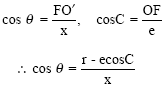 |
The horizontal component of F’ is ![]() The resultant horizontal force is
The resultant horizontal force is
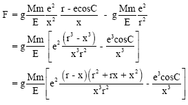 |
Since θ is very small, x ≈ FO’
 |
Since the value of r is about 60 times the value of e, this implies that the relative variation in the factor ![]() are negligibly small compare with the relative variation in the factor
are negligibly small compare with the relative variation in the factor ![]() and consequently we can replace x by r without loss of generality. Thus the horizontal component becomes
and consequently we can replace x by r without loss of generality. Thus the horizontal component becomes ![]() in the direction parallel to OO’. Similarly the vertical component is
in the direction parallel to OO’. Similarly the vertical component is ![]() in the direction at right angle to OO’.
in the direction at right angle to OO’.
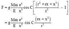
The vertical component of the differential force has no practical importance in connection with the generation of tides; it alters the apparent force by either reinforcing or counteracting the force of gravity. The horizontal component of the differential force along the surface of the earth is thus given as:
which has a maximum when C = 45°
It should be noted that whereas the attractive force exerted by the moon on a particle depends on the inverse square law of the moon’s distance, the differential forces and their components vary inversely with the cube of the moon’s distance. This is the equilibrium tidal theory.
The calculated tide generating forces in dynamical analysis are the same as for equilibrium tidal theory. However the actual tides are quite different because of land masses, the geometry of the earth and the earth’s rotation. The continents create closed ocean basin so the tide waves cannot progress around the globe. Instead it can reflect off the continental margin and oscillate in this basin as a standing wave. The moon rotates around the earth in the same direction as the earth rotates on its axis. Because of this, it takes 24 h 50 min for a point on the earth directly below the moon to make one complete revolution and again be directly beneath the moon[1]. This period of time is known as the tidal day. A semi diurnal tidal wave has a period of 12 h and 25 min.
 | |
| Fig. 1: | Attractive forces due to the Moon |
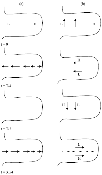 | |
| Fig. 2: | (a) Tidal oscillation without and (b) with geostropic forces |
Due to its daily rotation the earth itself experiences a centrifugal force. Objects or parcel of air or water, moving relative to the earth’s rotation experiences an additional centrifugal force. This is the coriolis force. Consider a standing oscillation of tidal co-oscillation in a uninodal gulf. When there is high water at one end there is low water at the other end of the gulf and the velocity is everywhere zero. But when the surface is level the velocities have their maximum values in the direction where the elevation is increasing[2]. Water will naturally flow from an area of high water or tidal crest to an area of low water or tidal trough. Because the wavelength is so long, it takes quite a while for the water to flow from crest to trough and consequently the movement is modified by the coriolis effect. The combined effect of the coriolis force and the tide generating forces is called the geostrophic effect on tidal motion.
Therefore when the geostrophic effects are incorporated in the Northern Hemisphere, they will build up a surface gradient to the right of the path of the stream so that there will be a subsidiary elevation of the water to the right. This gradient will increase the velocity and will be greatest therefore on the center-line where the nodal line existed in the absence of geostrophic effect.
If we consider an oscillation with period T and let the time t be measured from the instant of high water at the head of the gulf which is also the instant of high water as far as the first nodal line. At times t = 0, T/4, T/2, 3T/4, we have successive phases shown in Fig. 2a appropriate to when the geostrophic effects are absent. The broken line is the nodal line. At t = 0 when it is high water (H) at the head of the gulf, it is low water (L) at the entrance to the gulf and there are no streams. By the time t = T/4, the surface is level and the stream currents are at their maximum tending to produce high water (H) at the entrance at t = T/2. When the geostrophic effects are operative, the effect at t = T/4 is to give a gradient upward to the right of the stream line[3]. Hence at t = T/4, the surface will not be level; the surface is at high water at the north end of the original nodal line and at low water to the south of it. Between the areas of these elevation and depression, there will be a line nn’ which is at mean sea level. These elevation and depression will have their maximum values at T/4 and will be reversed at t = 3T/4. Figure 2b shows the sequence of events when geostrophic forces are effective. If we combine all the sequence of events in Fig. 2b, we obtain the diagram shown in Fig. 3.
At the intersection A of the lines NN’ and nn’, there will be no rise and fall of the surface. Along the line An, there will be high water at t = 0, along the line AN’ there will be high water at t = T/4, along the line An’ there will be high water at t = T/2 and along the line AN there will be high water at t = 3T/4. This implies that the original nodal line has shrunk to a central point A at which no tidal changes occur. Such a point is called an amphidromic point.
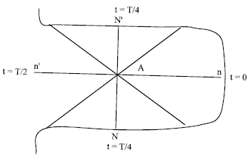 | |
| Fig. 3: | Sequence of event for a period T, showing co-tidal lines and amphidromic point |
It is also seen that at any one instant, all the points at high water lie on a line through A and this line rotates in a counter clockwise direction. Such lines are known as coital lines and are defined as the lines joining points at which high water occurs simultaneously. The amphidromic point A is a point of zero range and cotidal lines radiate from this point and rotate around it. The region of cotidal lines radiating from an amphidromic point is known as amphidromic region. The range of tides in such a system increases with distance from the amphidromic point where the range is zero. This is what happens in the northern hemisphere where a standing oscillation will be so modified by geostrophic effects that nodal lines degenerate into a point round which tidal oscillations appear to rotate in a counter clockwise direction. In the southern hemisphere the rotation of the amphidromic system is in the clockwise direction.
DISCUSSION
The tide on a body of water of mass m is given as:
For a unit mass the force is given as:
The Escravos Bar is on longitude 5011’E and
 |
This is the force per unit mass of water in the Escravos Bar. The nodal line does not exist in the Escravos Bar but in the ocean[2]. Thus the amphidromic point exists within the ocean.
The sun also exerts tide generating force in the same way as the moon. This force produces solar tidal wave. However the most influential body in generating tide is the moon. This is because the tide generating force is inversely proportional to the cube of the distance. Hence the enormous distance of the sun to the earth makes the solar tide generating force to be less comparable to that of the moon. Nevertheless it also makes a contribution to the generation of tide.
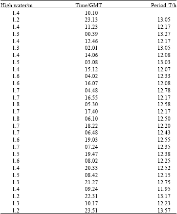
The period of oscillation is the time interval between two consecutive high waters or low waters at a particular place. However due to the variations in the force generating tides, the period of oscillation is not constant. In this work we have considered the 28 oscillations in the first fifteen days of the month of September, 2003 as available from the Tides Table prediction of the Nigerian Navy[4]. The time of high waters is used in getting the period of each oscillation. The mean period of oscillation is then calculated as the average of these periods. The periods of oscillations are as given in Table 1 from which the mean period = 12.51 h. We also found out that this is the average mean period for the low waters.
The calculated period shows that the oscillation in Escravos Bar is a semi-diurnal tidal oscillation. This is the same type of oscillation, which exists in the Irish Sea and the English Channel[5] and the Japan Sea[6]. A look at the first column of Table 1 shows that the high water ranges between 1.2 to 1.8 m. However a further look will show a certain trend in the variations. The first nine oscillations shows a range between 1.2 and 1.6 m and the last nine oscillations also show a similar range. However the ten oscillations at the centre of these show a range between 1.6 to 1.8 m. The implication is that of the fifteen days considered, the first five days have a relatively lower high water which could only be attributed to a relatively lower tide generating force. Similarly to the last five days considered. However from the sixth day to the eleventh day the high water were maximum. This could also be attributed to relatively a high attractive force.
It takes 29.5 days for the moon to orbit the earth[5]. In this period of time, the moon passes through its four phases from new moon to first quarter, full moon and finally third or last quarter before new moon re-appears. During the new moon and full moon phases, the earth, the moon and the sun are all aligned. The lunar and solar tides will be in phase and add constructively to produce what is called the spring tide. The spring tide has the largest tidal range or vertical distance between highest and lowest water levels.
| Table 1: | High Water, High water time and periods of Oscillations |
 | |
During the quarter phases of the moon, the lunar and solar tides add destructively. The lunar high tide coincides with the solar low tide to produce what is called the neap tides having the lowest tidal range. In this way neap tides and spring tides occur alternatively at two weeks intervals, as forthnightly tides.
CONCLUSION
We have shown that the lunar tide generating force per unit mass of water in the Escravos Bar is 1.47 x 10⁻⁷N. There exists a semi-diurnal oscillation in the Bar with a period of 12.51 h. The spring and neap tides occur within the Bar as forthnightly tides. For the month of September 2003, spring tides occur between the 6th and eleventh day of the month. The effect of geostrophic forces is to cause the nodal to degenerate to a point called the amphidromic point round which tidal oscillation appears to rotate in a counterclockwise direction. However due to the length of the Bar, the amphidromic point does not exist within the Bar.