
A. Abu- Saleem
Al -Balqa� Applied University, Al-Salt 19117, Jordan
Y. Al- Zu`bi
Al -Balqa� Applied University, Al-Salt 19117, Jordan
O. Rimawi
Al -Balqa� Applied University, Al-Salt 19117, Jordan
J. Al- Zu`bi
Al -Balqa� Applied University, Al-Salt 19117, Jordan
N. Alouran
Al -Balqa� Applied University, Al-Salt 19117, Jordan
Journal of Agronomy
Year: 2010 | Volume: 9 | Issue: 3 | Page No.: 119-125


ABSTRACT
The gravest environmental challenge that Jordan faces today is the scarcity of water. Indeed, water is the decisive factor in the population/resources equation Various techniques are available to quantify recharge; however, most of these are lumped and/or empirical approaches. The best alternative approach for such purposes is the use of a physically based hydrological model integrating all hydrological processes on basin scale. In this study GIS and RS technologies are applied to assist the simulation of the water balance components of the Hasa catchment, Jordan. The study area consists of 2,800 km2. It includes the well known phosphate mines. Wadi Hasa is the main perennial stream within the area. The techniques have been used to develop the land use and other necessary maps of the basin. A flexible, physically and GIS based, distributed recharge methodology, WetSpass, has been used for the estimation of long-term average spatially varying annual and seasonal water balance components: surface runoff, actual evapotranspiration and groundwater recharge. The simulated hydrological variables are made on pixel basis using a 90 m grid size. The groundwater recharge and surface runoff show mean values of 0.98 mm and 23.64 mm per year, respectively. The results show about 0.64 and 15.4% of the mean annual precipitation is effective in producing groundwater recharge and surface runoff respectively, while the rest and the major part is lost as evapotranspiration which is estimated 128.68 mm per year. Analysis of the simulated results shows that WetSpass is good enough to simulate the hydrological water balance components of the Hasa basin.
PDF Abstract XML References Citation
Received: April 20, 2010;
Accepted: June 25, 2010;
Published: September 28, 2010
How to cite this article
A. Abu- Saleem, Y. Al- Zu`bi, O. Rimawi, J. Al- Zu`bi and N. Alouran, 2010. Estimation of Water Balance Components in the Hasa Basin with GIS based WetSpass Model. Journal of Agronomy, 9: 119-125.
DOI: 10.3923/ja.2010.119.125
URL: https://scialert.net/abstract/?doi=ja.2010.119.125
DOI: 10.3923/ja.2010.119.125
URL: https://scialert.net/abstract/?doi=ja.2010.119.125
INTRODUCTION
The gravest environmental challenge that Jordan faces today is the scarcity of water. Indeed, water is the decisive factor in the population/resources equation (Al-Zubi et al., 2008). Whereas water resources in Jordan have fluctuated around a stationary average, the country’s population has continued to rise. A high rate of natural population growth, combined with periodic massive influxes of refugees, has transformed a comfortable balance between population and water in the first half of this century into a chronic and worsening imbalance in the second half (Al-Zubi et al., 2010).
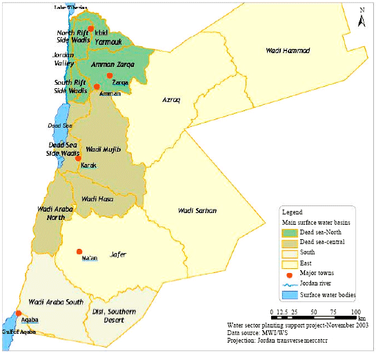
The study area consists of 2,800 km2 (Fig. 1). It includes the well known phosphate mines. Wadi Hasa is the main perennial stream within the area. The mean annual stream flow at Ghor Safi station is 47.4 MCM. The mean annual rainfall ranges from 100-300 mm. Presently, Wadi Hasa baseflow is committed to Ghor Safi area. Irrigation is being served through minor spring diversions or from wadi base-flow, but the amount of water used for irrigation has not been quantified. Domestic water use is largest at Hasa and Tafila towns. The industrial demand in this area is mainly for the phosphate mining at El-Hasa (Jiries et al., 2004).
WetSpass is based up on the foundation of time dependent spatially distributed water balance. WetSpass stands for water and energy transfer between soil, plants and atmosphere under quasi-steady state condition. It is a physically based model for estimation of the long term average spatial patterns of the groundwater recharge, surface runoff and evapotranspiration from long term average meteorological data together with land use, soil and groundwater depth maps by employing physical and empirical relationships (Batelaan and Woldeamlak, 2004; De Smedt et al., 2001).
The question addressed by this research is to estimate the water balance components of the Hasa basin in Jordan including; surface runoff, actual evapotranspiration and groundwater recharge by using Geographic Information Systems (GIS), remote sensed land use information and WetSpass model in order to suggest water management strategies to enhance the environment and socio-economic development.
 | |
| Fig. 1: | Location of hasa basin |
MATERIALS AND METHODS
El-Hasa basin is one of the main basins in Jordan which is located in the southern parts. The study area consists of 2,800 km2 (Fig. 1). It is known by industrial activities such as the well known phosphate mines. Wadi Hasa is the main perennial stream within the area. Wadi Hasa baseflow is committed to Ghor Safi area. Irrigation is being served through minor spring diversions or from wadi base-flow, but the amount of water used for irrigation has not been quantified. Domestic water use is largest at Hasa and Tafila towns. The industrial demand in this area is mainly for the phosphate mining at El-Hasa. The study has been conducted from 2007 to 2009 with the time frame of project.
The foremost important activity in the hydrological watershed modeling task is the delineation of the basin boundary. The watershed delineation in this study has been done by using the Digital Elevation Model (DEM) which is obtained from the Shuttle Radar Topography Mission (SRTM). 3DEM, Terrain Visualization and Flyby Animation software, has been used to display and perform some basic modifications on the DEM. ArcView GIS 3.2 and its spatial extensions are then used for further processing of the DEM and delineation of the basin.
A supervised land use classification method has been employed on the Enhanced Thematic Mapper Plus (ETM+) satellite imagery, which has been acquired from the Landsat Organization home page. Idrisi 32 software has been used to process the satellite images and to develop land use map of the study area. The soil map of the basin is obtained from the soil map data base of National Center for Agricultural Research and Extension (NCARE).
A physically based quasi-steady state time independent model, WetSpass, has been used to estimate the long-term average spatially varying water balance components. All input maps for the model are prepared by using ArcView GIS 3.2 and its spatial extensions. WetSpass gives various hydrologic outputs on yearly and seasonal (summer and winter) basis. Even though the model is originally developed mainly to compute the long-term average spatially distributed recharge of a basin, it also simulates runoff, evapotranspiration, interception, transpiration, soil evaporation and the error in water balance. The calculation is performed for each time scale and on each grid or cell, small plot of land of known size in the catchment. The grid size (or cell size) for this particular study is 90 m. This means that, every grid cell on the GIS map represents a plot of land of size 2,481.78 km2.
The results from the model can be analyzed in various ways. The analysis including; summer and winter output differences, analysis of spatial variations of recharge and runoff, as a function of land use and soil type and analysis of evapotranspiration and recharge as a function of elevation has been done.
Since all the out puts from the model are grid maps and do not contain tabular values, in some cases it is very helpful to combine two or more grid maps to get a combined map for ease of analysis. In this case the ArcView script called ‘combine.ave’ has been used to combine three different grids and to produce data base file (.dbf). The data base file from ArcView can be exported to spread sheet for further analysis and ease of plotting. The topography grid map, recharge and evapotranspiration grid maps have been combined for ease of analyzing the relationship between elevation with evapotranspiration and recharge. The land use and soil maps have also been combined with the recharge and surface runoff output maps to visualize the impact of different land covers and soil texture on the groundwater recharge and surface run off respectively.
RESULTS AND DISCUSSION
Evapotranspiration: Evapotranspiration is a determining factor in the water balance. WetSpass approach aims at describing the evapotranspiration process in a physically based way. The model calculates the total actual evapotranspiration (Fig. 2) as a sum of the evaporation of water intercepted by vegetation, the transpiration of the vegetative cover and the evaporation from the bare soil between the vegetation.
WetSpass simulated the average annual evapotranspiration of the basin to be 19 and 592.95 mm as the minimum and the maximum values, respectively. The mean and standard deviation of this distribution are 128.68 mm and 6.50 mm, respectively.
The average evapotranspiration accounts more than 80% of the total annual rainfall. This shows that evapotranspiration is the main processes by which water is lost in the basin. This is attributed to the high rates of radiation and the persistence of strong dry wind. The evapotranspiration is largely determined by the solar radiation, which is fairly constant between years. As a result evapotranspiration varies little from year to year, especially in the dry season.
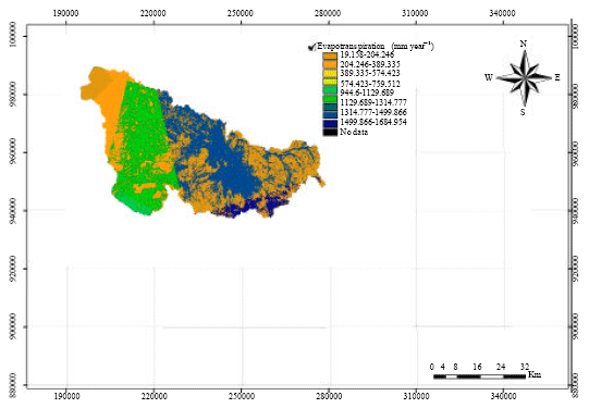 | |
| Fig. 2: | Simulated evapotranspiration with the WetSpass model for hasa basin |
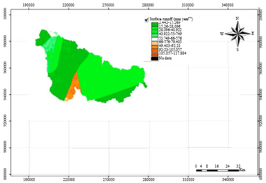 | |
| Fig. 3: | Simulated surface runoff with the WetSpass model for hasa basin |
Surface runoff: The WetSpass model uses the runoff coefficient method for the estimation of surface runoff. The surface runoff coefficient on the other hand is a function of vegetation type, soil texture and slope. Hence it is apparent that the surface runoff in Hasa basin does also vary spatially with topography and other catchment characteristics. Figure 3, shows the results of a simulated surface runoff with the WetSpass model for Hasa basin.
The simulated runoff varies from 2.44 mm year-1 to a maximum of 117.88 mm year-1 with a mean standard deviation of 7.18 mm year-1. It is very well known that most of the rainfall in Hasa basin comes as a thunder storms which result in forming a thin impermeable layer at the surface of the ground known as a crust phenomena, this phenomena increases the opportunity of the surface runoff.
Groundwater recharge: Recharge is the entry of water into the saturated zone of water made available at the water table surface, together with the associated flow away from the water table within the saturated zone (Freeze, 1969). Recharge is an important factor in evaluating groundwater resources but is difficult to quantify (Alley et al., 2002). The WetSpass model determines the long-term average spatially distributed recharge as a spatial variable dependent on the soil texture, land-use, slope, meteorological conditions etc. this is primarily to take into account the influence of the spatial variability of the land surface on the groundwater system (Batelaan and Woldeamlak, 2004).
The estimated groundwater recharge calculated by WetSpass for the present land use as shown in Fig. 4 ranges from zero to 12.83 mm year-1, with an average value of 0.976 mm year-1 and standard deviation of about 2.65 mm. This amount of infiltration into the groundwater depends on vegetation cover, slope, soil composition, depth to the water table, the presence or absence of confining beds and other factors. Recharge is promoted by natural vegetation cover, flat topography, permeable soils, a deep water table and the absence of confining beds.
All water bodies on average yield lower recharge values. This is evident from the fact that water bodies except some artificial reservoirs are characterized by high discharge and low recharge rates. Groundwater recharge is generally found to be much higher in nonvegetated land-uses than in vegetated land-uses (Gee et al., 1994) and is greater in areas of annual crops and grasses than in areas of trees and shrubs (Prych, 1998). On the other hand grazing, agricultural and range lands yield a higher recharge rate than bare areas, which is due to the vegetation cover in the former. However, the variation of recharge with land use type is less pronounced than its variation with soil type. In general the annual results analysis reveals that evapotranspiration is the most important hydrologic process in the basin, by which most of the precipitation is lost, than surface runoff and recharge.
Hasa is one of the most drought regions of Jordan. There are many causes of the structural food shortage of which moisture deficit plays a significant role.
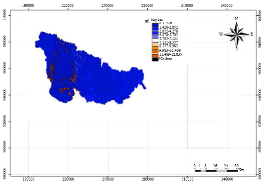 | |
| Fig. 4: | Simulated groundwater recharge with the WetSpass model for hasa basin |
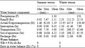
| Table 1: | Summary of the seasonal various water balance components |
 | |
Moisture stress is particularly severe due to the insufficient and erratic rainfall accompanied by larger evapotranspiration. As a result, irrigation development is taken as an essential component of the food security strategy to improve food production and agricultural productivity in the region.
Seasonal results analysis: The simulated seasonal outputs of the model are also seen (Table 1) to be governed by the soil type, land use class and topography in the same way as discussed for annual results. The winter season is characterized by higher rainfall amounts. It is obvious from results presented in Table 1, that actual evapotranspiration in winter season is higher than summer season in spite of the higher temperature degrees in summer season than winter season, but this is governed by the amount of the mean precipitation as shown is 3.3 and 150 mm in summer and winter, respectively.
CONCLUSIONS
Humans have exerted large-scale changes on the terrestrial biosphere, primarily through agriculture; however, the impacts of such changes on the hydrologic cycle are poorly understood. For example, conversion of natural rangeland ecosystems to agricultural ecosystems impacts the subsurface portion of the hydrologic cycle by changing groundwater recharge and flushing salts to underlying aquifers, which are both related to land use and/or land cover (Tarboton, 2003).
A modern nation, as a modern business, must have adequate information on many complex interrelated aspects of its activities in order to make decisions. Land use is only one such aspect, but knowledge about land use and land cover has become increasingly important as the nation plans to overcome the problems of haphazard, uncontrolled development, deteriorating environmental quality, loss of prime agricultural lands, destruction of important wetlands and loss of fish and wildlife habitat. Land use data are needed in the analysis of environmental processes and problems that must be understood if living conditions and standards are to be improved or maintained at current levels (Anderson et al., 1976).
In this study steady state spatially distributed water balance model WetSpass has been applied to calculate the water balance of the Hasa basin, Jordan. The model results show that all the water balance components are dependent on the soil type and land use classes. Thus it can be noted that lack of relevant land use map in any hydrologic modeling leads to a wrong output, which could lead to wrong decisions. In this study, GIS and remote sensing techniques have been applied to develop the land use map of the basin and IDRISI32 and ArcView3.2 has been used to processes the satellite imagery.
The model results show that the mean annual recharge in the basin is about 0.98 mm. The annual groundwater potential of the region is estimated to be 2.43 MCM. The simulated mean annual surface runoff in the basin is 23.64 mm. Only about 15.4% of the mean annual runoff is contributed in summer season while the rest is contributed from the winter rainfall. GIS tools are being widely used for delineation of watershed divide and identifying stream network. Many researches have proved that GIS delineation is better than hand delineation. Thru the study, the area of the delineated watershed was found 2,481.78 km2.
The simulated mean annual evapotranspiration is about 128.68 mm year-1. Analysis of the simulated results shows that WetSpass is good enough to simulate the hydrological water balance components of the Hasa basin provided that an accurate and up to date land use and soil maps are available. It has also seen that flow accumulation that both the groundwater recharge and surface runoff are accumulated towards the lower elevation points in the basin, i.e., the outlet of the catchment, which is an indication of the real flow characteristics of the ground and surface water systems.
In general, changes in land use and land cover are pervasive, increasingly rapid and can have adverse impacts and implications at local, regional and global scales. Thus by utilizing remote sensing technologies and implementing GIS mapping techniques, land use and land cover change of designated areas can be monitored and mapped for specific research and analysis. Also the dynamics of conversion of a certain type of land use into another form and its consequences on the environment can best be studied using GIS and RS technologies
In this study, the same land use map has been used for both summer and winter seasons. Even if much of the rainfall is expected in the summer season it would be also positive if the land use map for both seasons is developed separately for more accurate results. The size of the basin is so big compared to the number of meteorological stations from which the representative seasonal and annual precipitation data was collected. Thus it is necessary to have more meteorological stations at the different zones within the basin.
Missing data cloud better be filled and complied at the regional or national meteorological agencies. The largest amount of evapotranspiration simulated for the basin, relative to the groundwater recharge and the surface runoff, indicates that much effort is needed to change the environmental conditions of the basin, say it could be by re-forestation programs, which could induce more and more rainfall. Efforts have been made in this research, to modify the land use parameter table to make it a little more representative to the study area. However, a further study could be needed to further fine the land use, soil as well as runoff coefficient parameter tables of the study area. This could be done in cooperation with other professionals such as foresters, soil scientist, hydrologist and plant science specialists.
REFERENCES
- Al-Zubi, J., Y. Al-Zubi and S. Abubaker, 2010. Hydrology and water harvesting techniques of wadi muheiwir catchment area-the case study of Jordan. J. Applied Sci., 10: 298-304.
CrossRef - Al-Zubi, Y., A. Zyoud and J. Al-Zubi, 2008. Macroeconomic policy and water pricing impacts on the water consumption: The case of Jordan. J. Food Agric. Environ., 6: 461-465.
Direct Link - Alley, W.M., R.W. Healy, J.W. LaBaugh and T.E. Reilly, 2002. Flow and storage in groundwater systems. Science, 296: 1985-1990.
Direct Link - De Smedt, F., Y.B. Liu and S. Gebremeskel, 2001. Hydrological Modeling on Catchment Scale Using GIS and Remote Sensed Land Use Information. In: Risk Analysis II, Brebbia, C.A.(Ed.). WTI Press, Southampton, Boston, pp: 295-304.
Direct Link - Freeze, R.A., 1969. The mechanism of natural ground-water recharge and discharge. 1. One-dimensional, vertical, unsteady, unsaturated flow above a recharging or discharging ground water flow system. Water Resour. Res., 5: 153-171.
Direct Link - Gee, G.W., P.J. Wierenga, B.J. Andraski, M.H. Young, M.J. Fayer and M.L. Rockhold, 1994. Variations in water balance and recharge potential at three western desert sites. Soil Sci. Soc. Am. J., 58: 63-72.
CrossRefDirect Link - Jiries, A., T. El-Hasan, M. Al-Hweiti and K. Seiler, 2004. Evaluation of the effluent water quality produced at phosphate mines in central Jordan. Mine Water Environ., 23: 133-137.
Direct Link - Prych, E.A., 1998. Using chloride and chlorine-36 as soil-water tracers to estimate deep percolation at selected locations on the U.S. department of energy hanford site, Washington. U.S. Geol. Surv. Water Supply Pap., 2481: 1-67.
Direct Link