
A. Durak
Department of Soil Science: Faculty of Agricultural, Gaziosmanpasa University, 60250 Tokat, Turkey
A. Surucu
Research Institute, 63100 Sanliurfa, Turkey
Journal of Agronomy
Year: 2005 | Volume: 4 | Issue: 3 | Page No.: 191-195


ABSTRACT
The purpose of this study was to determine the relation between pedogenesis and landscape (LS) in various slope and elevations located in the coast of Black Sea region in north of Samsun, Turkey. The landscape is characterized by Quaternary fluvial deposits, tertiary calcareous rocks and mesozoic basalt. Eight pedons were examined by field investigation and laboratory soil characterization techniques. A Typic Haplustalf on the summit position had the greatest degree of pedogenesis. However, a Typic Ustifluvent, with the minimum soil formation, formed on toeslope position. The soils on shoulder and backslope position were determined as a moderate development formation.
PDF Abstract XML References
How to cite this article
A. Durak and A. Surucu, 2005. Soil Formation on Different Landscape in a Semi-humid Region of Turkey. Journal of Agronomy, 4: 191-195.
DOI: 10.3923/ja.2005.191.195
URL: https://scialert.net/abstract/?doi=ja.2005.191.195
DOI: 10.3923/ja.2005.191.195
URL: https://scialert.net/abstract/?doi=ja.2005.191.195
INTRODUCTION
Topography is a major factor in soil development and influences radiant energy intensity and amount of water enters the soil. Distinct landforms can be found over different topographies under varying climatic conditions[1]. Variations in topographical position will result in different moisture conditions. Soil erosion may differ in rate and scale in these landforms depending on slope[2]. Consequently, along a variable slope, there would be encountered an entire sequence of soil types, each having different profile features[3]. Many researchers[3-5] concluded that specific soils are associated with specific landforms and soil patterns are repeating and predictable. Therefore, examination of topography, a highly effective soil forming factor influencing soil development, may provide helpful clues on development degree of soils even they differ in age. Because a hillslope transect may include materials of different ages and sources[5]. Differences in topography can highly affect the degree of weathering and the thickness of solums. In order to determine the effect of climate, parent material and topography along a hillslope from sea level to 1000 m above sea level, soil profiles were open in different landscape. Morphological descriptions of soil in profiles were made on site and soil samples were taken from each soil horizon.
MATERIALS AND METHODS
The study area is located at the semi-humid region (14°17" N and 36°18" E ) of northern Turkey. This study was conducted between 1997 and 2000 years. Soils in the study area formed from different parent materials, landscapes and located over varying slopes and elevations[6]. The climate is semi-humid with warm rainy summers and cool humid winters. The annual precipitation is 700 mm at the sea side, it takes values as high as 1400 mm at the summit. The annual mean temperature is 14°C at the seaside[7]. Soil temperature regime was mesic and soil moisture regime was ustic. The geomorphic setting, precipitation, vegetation and parent material in each physiographic unit are different. The reason in differences of vegetation cover among different landscapes is due to the differences[7].
In this study, eight soil profiles along a hillslope were examined. Four landscape (LS) recognized were: 1. Flood plain at toeslope (LS1), 2. Shoulder and backslope (LS2), 3. Footslope (LS3) and 4. Highlands at summit (LS4). According to geological map of the study area the landscapes formed from fluvial deposits are quaternary, footslope, shoulder and backslope areas are tertiary and highlands are mesozoic age.
Soil samples, taken from each horizon, were analyzed to determine physical, chemical and mineralogical properties[8]. pH was determined in saturation extract (1:1)[9]. Organic matter content was measured by Walkley-Black Method[9] and total salt content by measuring electrical conductivity in saturation extract[9]. CaCO3 content in soils was measured with a Scheibler Calcimeter[10] and exchangeable cations were measured in extract of 1N NaoAc[9]. Soil texture was determined by hydrometer method[11] and cation exchange capacity was measured with Na extraction method[12]. Clay minerals were determined with an X-ray diffractometer[13]. Total iron and aluminum were determined by extracting with a mixture of aqua regia and HF then measuring the concentration in the aliquot with an atomic absorption instrument[14].
RESULTS AND DISCUSSION
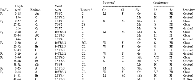
In this study, representative soil profiles of different landscapes were described based on morphological features of soils. Soils were classified based on the result of laboratory analysis and the field descriptions (Table 1).
The soils in the geomorphic surface over level or almost level fluvial deposits were young and indicating only weak soil development (LS1). Ogg and Baker[15] concluded that development of soils in the alluvial areas was highly affected by climate and time[9].
Two representative soil profiles (P1 and P2) were studied in this landscape. The soils in this landscape generally formed from fluvial deposits. Moreover, development of these soils was highly affected by human activities. Continuous rice cultivation and siltation resulted in migration of clays in soil profile, which in turn resulted in development of vertic properties.
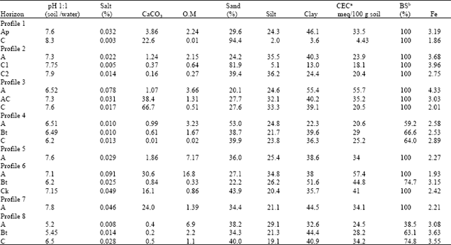
Sand content was increased with depth in these soils (LS1). Soil pH varied between 7.3 and 7.6. Due to leaching the soils were generally dry and poor in lime. Since they have been under cultivation for a long time, organic matter content was pretty low. Texture of topsoil was mainly clayey. Cation Exchange Capacity (CEC) changed 23.9 to 33.5 meq/100 g soil and base saturation was close to 100%. Iron content in topsoils was between 3.19 and 3.68% (Table 2). Dominant clay minerals occurred as smectite>palygorskite>kaolinite. The soils were classified as Vertic Ustifluvent due to the existence of an ochric horizon overlying a C horizon, ustic moisture regime and existence of prominent cracks (Profile 1). Soils without vertic properties (P2) were classified as Typic Ustifluvent.
Three representative soil profiles (P3, P4 and P5) were identified in the shoulder and backslope. This landscape, hereafter to be referred as LS2, do not cover extensive area in the study area. The profile development was moderate and horizon differentiation was prominent in these soils. Parent material was mainly limestone and basalt. Dominant processes in the differentiation of soil profiles were illuviation and calcification. In lower elevation; CaCO3 was accumulated at relatively shallower depths of soil profiles as compared to those at the higher elevations. However, as elevation increased, the depth of accumulation gradually increased due to increasing precipitation with elevation. Although there were marked indications of pedogenic carbonate accumulation in subsoils, calcic horizons were not identified. Because none of the pedons contained enough calcium carbonate to be classified as calcic horizon (Table 2).
Soil pH in topsoil was between 6.51 and 7.6 and soils were poor in salt. The lime content in the soils formed over limestone was quite high as compared to those formed over colluvial materials (basalt). The soil textures were SCL, CL and C in topsoils. CEC was between 34 and 55.7 meq/100 g soil except profile 4 in which CEC was lower due to lower clay content. Base saturation was 100% except profile 4 in which it was lower due to lower clay content. Fe content was between 2.27 and 4.33% (Table 2).
| Table 1: | Morphological properties of soil studied starting from lower elevation |
 | |
| aTexture abbreviations: S = Sand (y), C = Clay, L = Loam (y); bStructure abbreviations: Gr = Grade (W = weak, M = moderate, S = Strong), CL = Class (F = Fine, M = Moderate), Sh = Shape(G r= Granular, Sbk = Subangular Blocky, Ms = Massive). | |
| cConsistence: Ad = Air dry (H = Hard, S = Slightly, V = Very), Fc = Field capacity (FR = Friable, FI = Firm) | |
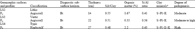
Clay accumulation observed in the profile 4, located at shoulder position was adequate to identify an argillic horizon (Table 2). Dominant clay mineral was smectite, however, palygorskite and kaolinite were also observed in lesser amounts. In soil development aspect were moderate due to silt/clay ratio and subsurface horizon depth (Table 3).
The morphology of the soils formed over LS2 were highly affected by the type of parent material. Pedogenic carbonate accumulation was not observed and basic cations were not abundant in soils formed over basalt because of high precipitation and leaching condition. These results could be attributed to in low pH and more acidic characteristics of soils. In this landscape, precipitation was high enough to translocate clays from surface horizons to the lower part of the soil profile. The amount of clay illuviated was high enough to be classified as an argillic horizon, indicating that precipitation is the main factor influencing the soil formation. As elevation increases, precipitation increases and temperature decreases, resulting in lower organic matter decomposition and consequently mollic epipedon formation. Mollic epipedons were observed in LS2. The soils on shoulder and backslope positions were classified in Haplustoll and Argiustoll.
Two soil profiles (P6 and P7) were opened at different locations in footslope (LS3). Profile 7 (P7), formed from colluvial parent material, transported form upper lands was located approximately 100 m above the sea level and exhibited little soil development. They were classified as Typic Ustorthents. Smectite was dominat clay mineral in P7. However, P6, located at 600 m above the sea level, formed over basaltic parent material and had a medium solum thickness. The accumulation of clay and observation of clay skins in the field indicated illuviation to be the dominant soil forming process in P6. These soils were classified as Typic Argiustolls due to the existence of a mollic epipedon and an argillic horizon. The value of pH in the P7 was higher as compared to that in the P6 which formed on colluvial material under low precipitation due to lower elevation.
| Table 2: | Some physical and chemical properties of soil profiles starting from lower elevation |
 | |
| aCEC= Cation exchange capacity, bBS= Base saturation | |
| Table 3: | Degree of pedogenesis according to properties of subsurface horizons |
 | |
| aS = Smectite, Pl = Palygorskite, K = Kaolinite, Il = Illite | |
In general, the soils in both profiles were poor in salt and their CaCO3 contents were between 0.84 and 30.6%. The clay content was greater in top soils of which textures were clay loam and clay in both profiles. CEC was lower in the P7 and base saturation was quite high in both profiles except Bt horizon in which the pH and base saturation were lower because of conditions mentioned above. Iron contents were ranged from 1.93 to 3.15% (Table 2). Development degree of Bt horizon in the Profile 6 indicated a moderate to high soil development in this landscape due to silt/clay ratio (Table 3) and profile depth as reported by Anjos et al.[2].
Profile 8 was opened in summit position, in which formed from basaltic parent material. Highlands (LS4) covers the largest portion of the study area. In this stable surface of landscape, the climatic conditions enabled further soil development under natural vegetation. Leaching of basic cation was severe due to the high precipitation. Therefore, CEC and base saturation of soils in highlands were lower as compared to those of soils located at footsolpe position. Similarly, Paudel and West[16] concluded from their study conducted in the Philippines that soils in footsolpe and highlands showed marked differences, especially in CEC and base saturation. Morphological observations revealed a relatively advanced soil development. A, B, C horizonation soils were predominantly occurred in this landscape (Table 1). Eluviation and illuviation were the main processes influencing the profile development of soils studied.
The solum thickness in LS4 was greater as compared to the soils located over LS2, LS3 and LS1 and soil development also was prominent. Soil pH was between 5.2 and 6.5 in profile 8, located at 1000 m above sea level. High precipitation and leaching of basic cations resulted in acidic conditions. Both salt and calcium carbonate content were very low. The soil texture was CL in topsoil and C in subsoil. The CEC increased with depth, changing from 24.5 to 34.2 meq/100 g soil. Although Fe content was 0.08% in topsoil, it was 3.63% in Bt horizon (Table 2). Degree of weathering and development in the Bt horizon indicated a relatively high soil development in this landscape due to silt/clay ratio and subsurface horizon depth (Table 3). Considering ochric epipedon and the argillic horizon the soils studied in LS4 were classified in Typic Haplustalfs.
The soils in the study area were ranked based on the classification and the degree of pedogenesis as Entisols>Mollisols>Alfisols. In a similar study, Langley and Bockheim[17] stated that the soil development at marine terraces in the Pacific Cost was ranked as Inceptisols<Spodosols<Ultisols in the degree of development based on time and soil profile development.
CONCLUSIONS
The impact of soil forming factors on soil development in the study area varies with changes in elevation from sea level. Differences in topography and precipitation resulted in development of distinct soil profiles even over the same parent material. Soils in footslope and highlands showed marked differences, especially in CEC and base saturation. Changes in vegetation along with topography and climate resulted in that soils were grouped in different classes. The results clearly showed the varying degree of soil forming factors influenced soil development over different elevation, precipitation and topographic conditions even within short distances and indicated which soils are dynamic and soil development still continues in all the landscapes.
ACKNOWLEDGMENTS
The authors thank Dr. S. Ersahin and Dr. H. Gunal for their critical review and Dr. M. Kilic, R. Kocyigit and K. Kilic for their valuable comments.
REFERENCES
- Tessier, A., P.G.C. Campbell and M. Bisson, 1979. Sequential extraction procedure for the speciation of particulate trace metals. Anal. Chem., 51: 844-851.
CrossRefDirect Link