
Manish Joshi
University School of Environment Management, Guru Gobind Singh Indraprastha University, Sector 16-C, 110078 Dwarka, New Delhi, India
Kiranmay Sarma
University School of Environment Management, Guru Gobind Singh Indraprastha University, Sector 16-C, 110078 Dwarka, New Delhi, India
Sanjay Keshari Das
University School of Environment Management, Guru Gobind Singh Indraprastha University, Sector 16-C, 110078 Dwarka, New Delhi, India
LiveDNA: 91.19183
International Journal of Zoological Research
Year: 2017 | Volume: 13 | Issue: 3 | Page No.: 105-112


ABSTRACT
Background and Objective: Indian desert monitor Varanus griseus koniecznyi Mertens, 1954 is the least common among all the monitor lizards found in India and there is an urgent need to understand habitat attributes and identification of conservation priorities areas of this endangered species. The aim of the present study was habitat suitability analysis of Indian desert monitor in Thar deserts of Rajasthan (TDR). Methodology: Habitat suitability analysis was carried out using GIS-based weighted overlay analysis. Different environmental variables that affect species distribution along with species occurrence data collected from ground survey were used as independent factors in this analysis. Thematic maps for all these factors were used as inputs and finally, all the geo-referenced inputs were overlaid in ArcGIS environment to derive the suitability map. Results: The result showed different potential habitat zones of Indian desert monitor in TDR which are 8.37, 45.55, 38.23, 5.37 and 2.48% as most suitable, moderately high suitable, moderately low suitable, low suitable and unsuitable, respectively. This further revealed, though the species can survive in wider part (most suitable, moderately high suitable, moderately low suitable) of TDR, only a small area of that (8.37%) is best suitable for the species. Of the best suitable habitats, maximum area comes in Jaisalmer district of western Rajasthan followed by Bikaner and Barmer districts. Conclusion: In order to save this conservation dependent species in TDR, the best suitable habitats of the species identified in this study need immediate conservation attention and should be protected from any kind of habitat degradation or alteration in future.
PDF Abstract XML References Citation
Received: August 28, 2017;
Accepted: October 09, 2017;
Published: October 19, 2017
How to cite this article
Manish Joshi, Kiranmay Sarma and Sanjay Keshari Das, 2017. Habitat Suitability Analysis of Indian Desert Monitor (Varanus griseus koniecznyi Mertens, 1954) in Thar Desert of Rajasthan Using Geo-spatial Technology. International Journal of Zoological Research, 13: 105-112.
DOI: 10.3923/ijzr.2017.105.112
URL: https://scialert.net/abstract/?doi=ijzr.2017.105.112
DOI: 10.3923/ijzr.2017.105.112
URL: https://scialert.net/abstract/?doi=ijzr.2017.105.112
INTRODUCTION
India is one of the recognized mega diverse countries of the world representing about 7.43% of the world’s total faunal species1. Reptiles are one of the diverse and important faunal groups and India stands fifth in global reptilian diversity2. They occupy almost all types of ecosystem on the earth and represent one of the four classes of terrestrial vertebrates. Among reptiles, saurians or lizards are the major group playing an important role as predators in the terrestrial ecosystems and also as pest controllers in agricultural and forest ecosystems, thus helping mankind.
Currently, habitat fragmentation, degradation and loss and illegal trading has resulted in many reptiles been pushed to the verge of extinction. The problem is more acute in developing countries, where wildlife and biodiversity conservation is often less prioritized3. Monitor lizards being large and conspicuous animals are not an exception. In India four species of monitor lizards are found. They are Bengal monitor Varanus bengalensis (Linnaeus, 1758), water monitor Varanus salvator (Laurenti, 1768), yellow monitor Varanus flavescens (Gray, 1827) and Indian desert monitor Varanus griseus koniecznyi Mertens, 1954. Among these the Bengal monitor is the most common, while Indian desert monitor is the least common4,5. The present study deals with the Indian desert monitor (Fig. 1) that currently found in the desert areas of India and Pakistan4-12. In India, the main population of this species is confined to the Thar desert of Rajasthan (TDR) where the population is highly declined due to widespread habitat destruction, urbanization, expansion of agriculture with introduction of Indira Gandhi Nahar Project (IGNP) and also, because of poaching, mainly for their skin12. According to Red Data Book it is an endangered species and listed under Schedule I of the Indian Wildlife (Protection) Act, 1972 and Appendix I of CITES, though IUCN has not yet assessed status of this species13-15. Hence, there is an urgent need to understand habitat attributes and identification of conservation priorities areas of this endangered species in order to protect them from further exploitation.
Habitat suitability analysis of wildlife using GIS and remote sensing tools is successfully used in the past for many conservation dependent species16-23. GIS-based analysis has advantage in particular, when ground survey for a target species faces limitations to access a large area or sometime inaccessible area within a short time frame24,25. However, use of geo-spatial technology in habitat assessment also requires the ground survey data that make the analysis more valuable and accurate26.
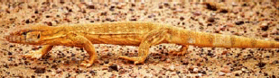 | |
| Fig. 1: | Indian desert monitor |
In the present study, GIS-based weighted overlay analysis27,28 is carried out to find out the spatial pattern of suitable habitats of Indian desert monitor in TDR using different environmental variables along with species occurrence data collected from ground survey. The aim of the present study was a pioneer attempt in India to carry out habitat suitability analysis of any reptile under geo-spatial environment.
MATERIALS AND METHODS
Study area: The study area is the Thar desert of Rajasthan (22°30’-32°05'N and 68°05’-74°45'E). It covers an area of about 1,91,650 sq. km and spreads over 13 districts of Rajasthan. It includes entire Ganganagar, Hanumangarh, Bikaner, Jaisalmer, Barmer, Jodhpur and Churu districts and part of Nagaur, Ajmer, Pali, Jalore, Jhunjhunun and Sikar districts (Fig. 2). It comes under the Biogeographic Zone 3A-Thar Desert29 which represents a unique ecosystem supporting a rich biodiversity. It is bounded by the Aravali hills in the east, the fertile Indus and Nara valley in the west, the great salt marsh of Kuchchh in the south and the semiarid districts of Haryana and Punjab in the north. It is an extension of the Sahara desert, through Arabian and Persian deserts and continues with the desert portion of Pakisthan on its west30.
Field data collection: The present study was undertaken from October, 2012-September, 2015 during which field survey for Indian desert monitor was carried out in TDR. Population of the species was enumerated through intensive search in different parts of TDR following mostly ‘perambulation’ method31,32, though ‘belt-transect’ method33 was followed at selected sites viz. Desert National Park, Jaisalmer and Jorbeer, Bikaner. The GPS points were taken along with habitat and microhabitat information for each encounter of the species that was used in habitat suitability analysis.
Preparation of thematic maps and habitat suitability modelling: Habitat suitability analysis was carried out using GIS-based weighted overlay analysis which is a component of spatial multicriteria evaluation technique and that assigns more importance to some criteria over others23-28.
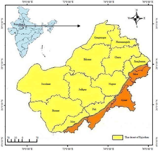 | |
| Fig. 2: | Map of study area |
The most useful application of GIS in this analysis is use of geographically referenced input data for different criteria assignment of percentage influences to those criteria, weights (1-9) to different attributes within each criterion and finally overlay various geo-referenced inputs to derive useful results. The technique allow the user to assign influences and weights to different classes in accordance with their relative importance in terms of suitability for the species that may be derived from knowledge from available literature or piece of information collected on habitat and microhabitat of the species through ground survey.
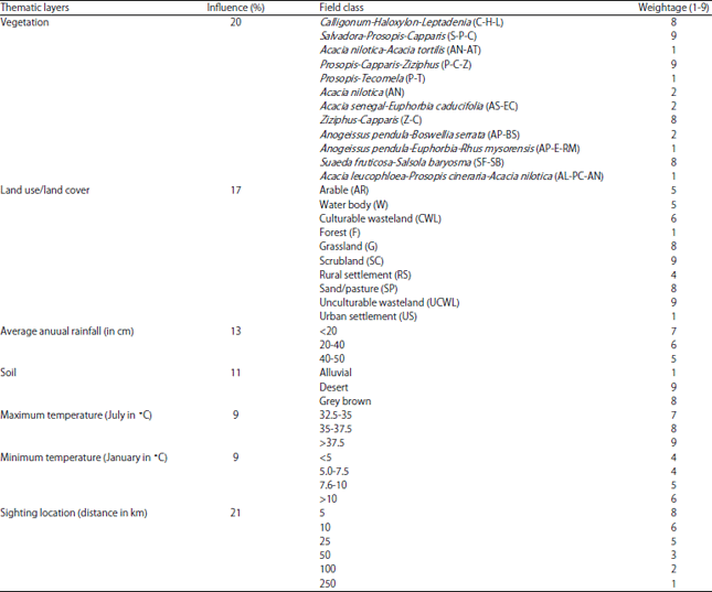
In this study, different ecological variables such as vegetation, land use/land cover, average annual rainfall, soil, monthly maximum and minimum temperatures along with species occurrence data collected from ground survey were used as inputs. Vegetation map of TDR was prepared from Resource Atlas of Rajasthan as source34, which was geo-referenced and manually digitised with few modifications based on ground survey (Fig. 3a). Land use land cover map of the TDR was prepared from districts planning maps of Rajasthan as source35. Relevant district planning maps (Map No. 056-NA/DP-2000-97, 3849-101D'-01, 7440-103D'-97. 2535-101D'96, 2640-101D'96, 7349-103D'-98, 3800-101D'-01, 2456-101D'96, 019-NA/DP-2000-95, 2281-101D'-95, 3000-101D'-98, 611-105D'-02, 059-NA/DP-2000-97) were scanned, geo-referenced, manually digitised, merged and cut with base map of TDR to prepare the final map (Fig. 3b).
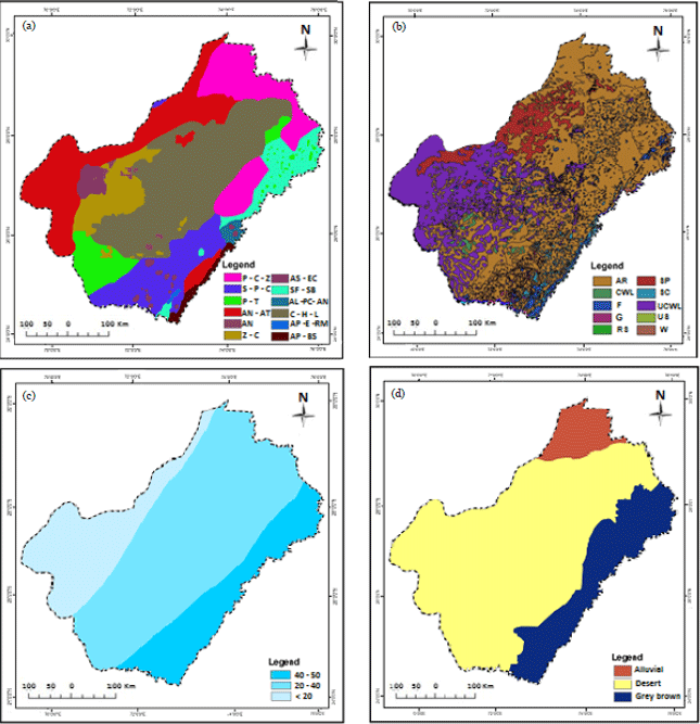 | |
| Fig. 3(a-d): | (a) Vegetation of TDR, (b) Land use/ land cover of TDR, (c) Average annual rainfall (in cm) of TDR and (d) Soil types of TDR |
Annual rainfall map of TDR was prepared using source map from Roy and Smykatz-Kloss36, which was geo-referenced and manually digitised (Fig. 3c). Other maps viz. soil map, monthly maximum and minimum temperature maps were generated using source maps from Upadhyaya37, which were geo-referenced and digitised (Fig. 3d, Fig. 4a,b). All the maps were geometrically rectified and projected using geographic projection system UTM. The spheroid and datum used were WGS 1984 with UTM zone 42N. The geo-databases for all maps were generated in ArcGIS environment. The GCPs (Ground Control Points) for species sightings were imported on the base map and multiple ring buffers were generated for all the locations (Fig. 4c). All the polygon features were converted into raster with 50 meters pixel size. Finally, all the geo-referenced inputs were overlaid in ArcGIS environment to derive the suitability map (Fig. 4d).
RESULTS AND DISCUSSION
Habitat suitability analysis for any species under geospatial environment is outcome of degree of interactions between biotic and abiotic factors and the species.
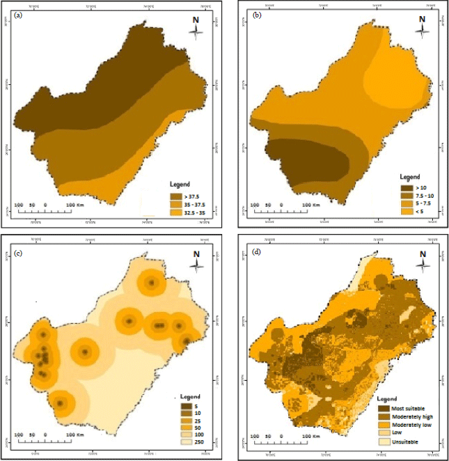 | |
| Fig. 4(a-d): | (a) Maximum temperature (July in °C) of TDR (b) Minimum temperature (January in °C) of TDR, (c) Location buffer of Indian desert monitor in TDR and (d) Habitat suitability of Indian desert monitor in TDR |
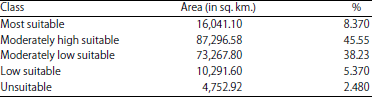
In this study, thematic maps for different environmental variables such as vegetation, land use/land cover, average annual rainfall, soil, monthly maximum and minimum temperatures along with species occurrence data collected from ground survey were prepared under geospatial environment and used as independent factors (Table 1, Fig. 3a-d and 4a-c) to produce the final habitat suitability map of Indian desert monitor in TDS. The map (Fig. 4d) showed different potential habitat zones of Indian desert monitor in TDR which are 8.37, 45.55, 38.23, 5.37 and 2.48% as most suitable, moderately high suitable, moderately low suitable, low suitable and unsuitable, respectively (Table 2). This reveals though the species can survive in wider part (most suitable, moderately high suitable, moderately low suitable) of TDR, only a small area of that (8.37%) is best suitable for the species. Of the best suitable area, maximum area falls in Jaisalmer district followed by Bikaner and Barmer districts. These areas are crucial habitats for the species that need immediate conservation attention and should be protected from any kind of habitat degradation or alteration in future in order to save this endangered species in TDR. The study also shows a small part (7.85%) of TDR is either less suitable or unsuitable for the species.
| Table 1: | Influences and weightages of different thematic layers used for habitat suitability analysis of Indian desert monitor in TDS |
 | |
| Table 2: | Habitat suitability of Indian desert monitor in TDS |
 | |
These areas correspond to either hilly terrain at the edge of Aravali mountain range or areas that at present face large scale habitat alternation or degradation due to expanding human settlement and agricultural activities.
In the current study, of the best suitable area for Indian desert monitor, maximum area comes in Western Rajasthan (i.e., Jaisalmer, Bikaner and Barmer districts). In absence of any detailed study on this species, previous studies10-12 about occasional reporting of the species in TDR supports the finding. The habitat suitability map from this study effectively defines desert monitor’s presence in the study area. Similar findings have also been reported in previous studies16-23 for other conservation dependent species.
CONCLUSION
Habitat suitability analysis and identification of crucial habitats for Indian desert monitor in TDR can be considered as one of the preliminary conservation initiatives for this endangered species. The study revealed only a small area of TDR as crucial habitats for the species and these areas need to be protected immediately.
SIGNIFICANCE STATEMENT
The study brings into knowledge the crucial habitats of Indian desert monitor lizard in the Thar desert of Rajasthan under geospatial environment. The species is one of the most poorly known and conservation dependent species and lacks any study on its current status. Therefore, the present study is no doubt one of the conservation initiatives in India for this endangered species.
ACKNOWLEDGMENTS
The authors express their sincere thanks to the following personnel and institutions: Sri R.K. Tyagi, Chief Wildlife Warden, Rajasthan for granting permission to carry out this study, University Grants Commission, New Delhi for funding a research project to carry out this study (Project No. 41-77/2012-SR); Sri Anoop K.R., Filed Director, Desert National Park and Sri Surat Singh Poonia assistant Conservator of Forest, Talchhapar Wildlife Sanctuary for their cooperation and logistic support during field surveys, Mr. Tarun Singh, Jaisalmer for assisting in field surveys, Prof. Anubha Kaushik, Dean, USEM, GGSIP University, New Delhi for providing necessary facilities and for her constant encouragement throughout the study.
REFERENCES
- Kushwaha, S.P.S., S. Munkhtuya and P.S. Roy, 2000. Geospatial modelling for goral habitat evaluation. J. Indian Soc. Remote Sens., Vol. 28.
CrossRef - Koch, A., T. Ziegler, W. Bohme, E. Arida and M. Auliya, 2013. Distribution, threats and conservation status of the monitor lizards (Varanidae: Varanus spp.) of Southeast Asia and the Indo-Australian archipelago. Hepitol. Coserv. Biol., 8: 1-62.
Direct Link - Auffenberg, W., H. Rehman, F. Iffat and Z. Perveen, 1990. Notes on the biology of Varanus griseus koniecznyi Mertens Sauria: Varanidae. J. Bombay Nat. History Soc., 87: 26-36.
Direct Link - Baig, K.J., R. Masroor and M. Arshad, 2008. Biodiversity and ecology of the herpetofauna of Cholistan Desert, Pakistan. Russian J. Herpetol., 15: 193-205.
Direct Link - Solanki, R., A. Pande, A. Vasava, A. Singh and C.M. Bipin, 2015. Contributions to Herpetofauna of Jaisalmer District-some photographic records. Newslett. South Asian Reptile Network, 17: 50-55.
Direct Link - Hill, G.J. and G.D. Kelly, 1987. Habitat mapping by Landsat for aerial census of kangaroos. Remote Sens. Environ., 21: 53-60.
CrossRefDirect Link - Bian, L. and E. West, 1997. GIS modeling of elk calving habitat in a prairie environment with statistics. Photogram. Eng. Remote Sens., 63: 161-167.
Direct Link - Santos, X., J.C. Brito, N. Sillero, J.M. Pleguezuelos, G.A. Llorente, S. Fahd and X. Parellada, 2006. Inferring habitat-suitability areas with ecological modelling techniques and GIS: A contribution to assess the conservation status of Vipera latastei. Biol. Conserv., 130: 416-425.
CrossRefDirect Link - Dash, P.P., P.K. Joshi, P.S. Roy and A.D. Tillu, 2012. Predictive habitat suitability modeling for prey and predator (Tiger) in Palamau Tiger Reserve, India. Int. J. Integr. Sci. Innov. Technol., 4: 20-28.
Direct Link - Singh, R., P.K. Joshi, M. Kumar, P.P. Dash and B.D. Joshi, 2009. Development of tiger habitat suitability model using geospatial tools-a case study in Achankmar Wildlife Sanctuary (AMWLS), Chhattisgarh India. Environ. Monitor. Assess., 155: 555-567.
CrossRefDirect Link - Malczewski, J., 2004. GIS-based land-use suitability analysis: A critical overview. Progr. Plann., 62: 3-65.
CrossRefDirect Link - Walke, N., G.P.O. Reddy, A.K. Maji and S. Thayalan, 2012. GIS-based multicriteria overlay analysis in soil-suitability evaluation for cotton (Gossypium spp.): A case study in the black soil region of Central India. Comput. Geosci., 41: 108-118.
CrossRefDirect Link - Dieni, J.S. and S.L. Jones, 2002. A field test of the area search method for measuring breeding bird populations. J. Field Ornithol., 73: 253-257.
CrossRefDirect Link - Carpio, A.J., M. Cabrera and F.S. Tortosa, 2015. Evaluation of methods for estimating species richness and abundance of reptiles in olive groves. Herpetol. Conserv. Biol., 10: 54-63.
Direct Link - Roy, P.D. and W. Smykatz-Kloss, 2007. REE geochemistry of the recent playa sediments from the Thar Desert, India: An implication to playa sediment provenance. Chemie der Erde-Geochem., 67: 55-68.
CrossRefDirect Link