
A. Seal
National Bureau of Soil Survey and Land Use Planning, Kolkata, 700091 West Bengal, India
R. Bera
National Bureau of Soil Survey and Land Use Planning, Kolkata, 700091 West Bengal, India
K.D. Sah
National Bureau of Soil Survey and Land Use Planning, Kolkata, 700091 West Bengal, India
D. Sarkar
National Bureau of Soil Survey and Land Use Planning, Kolkata, 700091 West Bengal, India
A.K. Chatterjee
Department of Soil Science, Visva Bharati University, Santiniketan, 731236 West Bengal, India
P. Bhattacharyya
BK21 Advanced Geo-Environment Research Team, School of Civil and Environmental Engineering, Kunsan National University, Kunsan, 573-701, Jeonbuk, Korea
K. Kim
BK21 Advanced Geo-Environment Research Team, School of Civil and Environmental Engineering, Kunsan National University, Kunsan, 573-701, Jeonbuk, Korea
S.H. Kim
BK21 Advanced Geo-Environment Research Team, School of Civil and Environmental Engineering, Kunsan National University, Kunsan, 573-701, Jeonbuk, Korea
International Journal of Agricultural Research
Year: 2008 | Volume: 3 | Issue: 2 | Page No.: 121-130


ABSTRACT
The study deals with village level land use planning for Sagar Island, West Bengal, India; conceived through the integration of various factors like available land and water resources as well as socio-economic factors viz. land holding sizes, social obligation and economic conditions of farmers. The study was conducted during the period 2002 to 2005, in Jeebantala village of Sagar block (South 24 Parganas district of West Bengal) which lies in between 88 °0737.2 and 88 °0831.2 E longitudes and 22 °4138.4 and 22 °4235.4 N latitudes covering an area of 146.42 ha. Four soil series identified through detailed soil survey were classified as Inceptisols and Entisols. They were evaluated for land capability classification and soil site suitability for rice, potato, sunflower, chilli, grass pea and fodder grass (Dinanath). Socio-economic study of the area revealed that marginal (<1 ha) group dominated the farming community sharing 77.25% of total population. Based on soil-site suitability evaluation of different crops, results obtained from crop experiments and constraints perceived by different group of farmers, various rice based crop sequences were formulated. Rainfed rice-chilli and rainfed rice-sunflower were suggested for saline soils where as rainfed rice-potato and rainfed rice-grasspea were suggested for non-saline soils.
PDF Abstract XML References Citation
How to cite this article
A. Seal, R. Bera, K.D. Sah, D. Sarkar, A.K. Chatterjee, P. Bhattacharyya, K. Kim and S.H. Kim, 2008. Appraisal of Natural Resource Database for Alternate Agricultural Land Use at Village Level Under Saline Environment-A Case Study from Sagar Island, India. International Journal of Agricultural Research, 3: 121-130.
DOI: 10.3923/ijar.2008.121.130
URL: https://scialert.net/abstract/?doi=ijar.2008.121.130
DOI: 10.3923/ijar.2008.121.130
URL: https://scialert.net/abstract/?doi=ijar.2008.121.130
INTRODUCTION
Remarkable improvement in agricultural production has been achieved in India during the past 3 to 4 decades. However, inappropriate cropping patterns have deteriorated the soil and water quality they are by creating unprecedented problems for the existing ecosystem. But to achieve sustainable development, sustainable utilization of natural resources is essential (Tang et al., 2005). Hence it is essential to maintain a balance in the potential use of natural resources, selection of suitable crops, judicious use of agricultural inputs and effective management practices for developing an optimum land use plan (Chattopadhyay, 1997).
The coastal soils of India exhibit a great deal of diversity in terms of climate, physiography and physical characteristics (Sen et al., 2000). Soil salinity poses the major problem, particularly in the post rainy season, which hampers the pace of production. Besides salinity, lack of good quality irrigation water is another limiting factor towards multicropping practices. However, location specific assessment of natural resources viz. soil and water and identification of major constraints are the primary basis for sustainable development of coastal agriculture (Bandyopadhyay et al., 2001). In this regard selection of new cropping sequences for diversification of existing cropping patterns towards more balanced cropping system have become important for increasing agricultural production combined with poverty alleviation, environmental preservation and to meet the ever increasing demand for cereals, vegetables, pulses and oilseeds (Newaj and Yadav, 1992). Hence the present study aims to identify the existing natural resources in the study areas and to develop an alternate land use plan at village level with special reference to soil salinity.
MATERIALS AND METHODS
The study was carried out in the village Jeebantala lying in between 88 °0737.2 to 88 °0831.2 E and 22 °4138.4 to 22 °4235.4 N and covering an area of 146.42 ha in Sagar block, South 24 Parganas, West Bengal, India. The area belonged to Gangetic delta, hot, moist, sub-humid agro-ecological region (Velayutham et al., 1999). Rice-rice crop sequence is the principal land use of the area followed by vegetables and oilseeds in some pockets of upland and midland. Soil series were identified through detailed soil survey on 1:4000 scale (IARI, 1970) and classified as per Soil Survey Staff (1998). Soils were analyzed for physico-chemical properties (Jackson, 1973) and fertility status (Page et al., 1982). Quality of irrigation water was estimated according to the procedure followed by Tandon (1999). Soils were evaluated for suitability of major crops using the methods suggested by FAO (1976) and Sys et al. (1993).
In order to analyze the interactions among the sociological and crop productivity variables, socio-economic survey was conducted using an interview schedule especially developed for the purpose (Ray and Mandal, 1999). Hundred sample farmers were selected using random sampling technique and interviewed successfully as per schedule (Sarker and Sinha, 2003) for projecting their socio-economic conditions. Crop experiment consisted of six rice based crop sequences with kharif rice (Oryza sativa) in monsoon followed by six rabi crops in winter viz. boro rice (Oryza sativa L.), potato (Solanum tuburosum L.), Sunflower (Helianthus annus L.), Chilli (Capsicum annum), grass pea (Lathyrus sativus L.) and Dinanath grass (Pennisetum pedicellatum). Chemical fertilizers were applied during b oth kharif and rabi seasons according to the dozes recommended for the area (Bhattacharyya, 1998) and the crops were raised following standard package of agronomic practices (Bandyopadhyay et al., 2001) for respective crops viz. date of sowing and harvesting, fertilizer application, interculture, irrigation management and plant protection measures. Statistical analyses were carried out using SPSS 13.0.
RESULTS AND DISCUSSION
Land use planning of an area requires a minimum data set of natural resources in terms of soil, water and socio-economic issues. Integrating these components with scientific wisdom facilitates the transfer of technology at farmers level and makes the land use plan easily adaptable and economically viable.
Soil Resources
Four soil series viz. Jeebantala 1 (Jbn 1), Jeebantala 2 (Jbn 2), Jeebantala 3 (Jbn 3) and Jeebantala 4 (Jbn 4) were identified in the area. Soils of Jbn 1 were very deep, moderately well drained upland with silty clay loam surface texture, slightly saline (Ece : 4.1 to 4.5 dS m-1) and classified as fine,
| Table 1: | Physico-chemical properties and fertility status of different soil series |
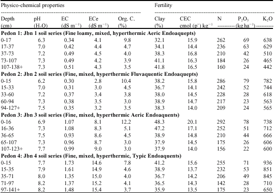 | |
mixed, hyperthermic, Aeric Endoaquepts (Table 1). Soils of Jbn 2 were very deep, moderately drained midland with silty clay loam surface texture, non saline (ECe : 2.8 to 3.5 dS m-1) and classified as fine, mixed, hyperthermic, fluvaquentic endoaquepts. Soils of Jbn 3 were very deep, poorly drained lowland with silty clay surface texture, moderate salinity (EC: 8.1 to 9.0 dS m-1) and classified as fine, mixed, hyperthermic, typic endoaquepts. Soils of Jbn 4 were very deep, very poorly drained lowland with silty clay loam surface texture, strongly saline (EC: 14.6 to 15.4 dS m-1) and classified as fine, mixed, hyperthermic typic endoaquepts.
In general the soils of Jbn 1, Jbn 2 and Jbn 3 soil series were slightly acidic to neutral (pH: 6.2 to 7.7) in reaction while soils of Jbn 4 soil series were slightly alkaline (pH: 7.7 to 8.2) in nature. Electrical conductivity values of soils of Jbn 1 ad Jbn 2 soil series (0.34 to 0.51 dS m-1 and 0.30 to 0.38 dS m-1, respectively) were more or less same while slightly higher values were obtained for Jbn 3 and Jbn 4 soil series (0.93 to 1.07 dS m-1 and 1.35 to 1.73 dS m-1, respectively) Organic carbon content of surface soils of all the soil series was high (9.8 to 12.2 g kg-1) except in Jbn 4 soils series. All the surface soils were medium in available nitrogen content (255 to 292 kg ha-1) and available P2O5 content (69 to 79 kg ha-1) where as available Potash was of high level (638 to 936 kg ha-1) and the values generally decreased down the soil profile depth with some exceptions.
Water Resources
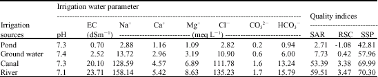
Groundwater and ponds were the only viable source of irrigation in the area, which covered 7.51 and 10.27% of total cultivable upland and midland respectively (Table 2). Studies on quality of irrigation water indicate that saline irrigation water is the major problem in this area. Lowest EC value (0.63 to 0.74 dS m-1) was obtained for pond water followed by groundwater (EC - 1.76 to 3.01 dS m-1), canal water (EC - 12.24 to 19.36 dS m-1) and river water (EC - 16.09 to 21.96 dS m-1). The higher EC value of river water might be due to its close connection with the sea. Low ECw of pond water (less than 0.75 dm-1) indicates that it would not lead to soil salinization if used for irrigation
| Table 2: | Irrigation water quality (Pooled data-pre monsoon, monsoon and post monsoon) of different sources |
 | |
| Table 3: | Demographic features and land characteristics of the study area |
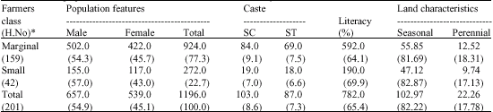 | |
| *: H. No: House hold number; Values in parentheses indicate percentage, SC: Schedule Caste; ST: Schedule Tribe | |
purposes. Water attributes like Na+, Ca2+, Cl–, CO32– and HCO3– followed a trend similar to ECw values. Considering the Sodium Adsorption Ratio (SAR) and Residual Sodium Carbonate (RSC) values both pond water and ground water samples may be rated as safe while canal and river water were practically unsafe for irrigation purpose (Richards, 1954; Ayres and Westcot, 1985).
Socio-Economic Conditions
Two categories of farmers viz marginal (< 1 ha) and small (1-2 ha) were identified in the study area on the basis of their operational land holding sizes (Table 3). The study area represented more or less similar trend with respect to farm holding sizes in the coastal ecosystem of West Bengal where proportion of marginal holdings were higher (Yadav, 1999). Out of the total household (201), 79.1 percent comprised of marginal farmers and the rest 20.9% belonged to small farmers category. In general literacy percent and average family size showed an increasing trend with increase in operational land holding size of the farmers. Majority of schedule cast (81.55 of their total population) and schedule tribe (79.31% of their total population) belonged to marginal farmers category.
Present Land Use
Rice-rice crop sequence is principally followed in the area with vegetables and oilseeds in some pockets of upland and medium land. Marginal farmers owned the major share of total cropped area (68.87 ha) in comparison to small farmers (56.87 ha). For both the categories maximum yield was obtained from upland (2.95-10.50 ton ha-1) while the minimum yield was recorded from lowland (1.87-2.10 ton ha-1) areas (Table 4). Cropping intensity was maximum in midland area followed by upland and lowland areas. The marginal farmers in the midland area cultivated Grass pea mainly as utera crop. Lowland areas were mostly monocropped except few patches and remained fallow during the rabi (winter) season.
Live Stock Status
Livestock, which serves as a backbone of rural agriculture includes animals and poultry birds. The average number of livestock per household increased with land holding size. Maintenance cost of livestock was lower in case of marginal farmers since they engaged more family labour for livestock maintenance in comparison to small farmers. Availability of fodder is not sufficient for the livestock population of the area. Shortfall in fodder requirement of livestock (Ilacob, 1985) was recorded as high as 273.93% in case of small farmers and 26.43 percent for the marginal farmers (Table 5).
| Table 4: | Present land use of the study area |
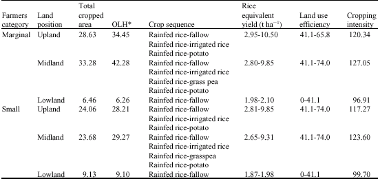 | |
| *: OLH: Operational Land Holding | |
| Table 5: | Livestock of the study area |
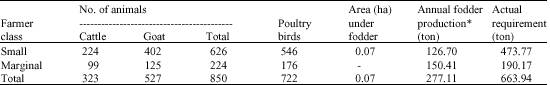 | |
| *: Fodder production calculation include total straw production | |
| Table 6: | Relationship between socio-economic factors and crop production |
 | |
| **: Significant at 1% level; *: Significant at 5% level; NS: Not Significant, Note: Degrees of freedom = 99 | |
Relationship Between Social Factors with Food Production
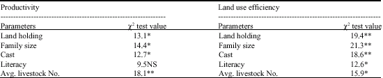
Productivity and land use efficiency of an area reflect the extent and degree of utilization of natural resources in agriculture (Mukhopadhyay et al., 2004). Pearchan chi square test was used to evaluate the degree of association of the socio-economic factors viz land holdings, family size, literacy, caste and average livestock number with productivity and land use efficiency (Table 6). Family size has a significant influence on the land use efficiency especially in the coastal areas (Sagar Island), which are mostly inhabited by the marginal farmers. Hence the poor socio-economic condition of the farm owners compel the utilization of family members as farm labour in order to obtain maximum benefits from marginal land holding sizes. In this respect increase of family size indirectly influences the operational activities and consequently the land use efficiency. Utilization of natural resources in the study area has been greatly influenced by socio-economic status of the farming community. Similar findings were reported by Kumar et al. (1997) in their study of socio-economic impact on land resource management.
Soil Site Suitability of Different Crops
The soil is given a suitability rating depending on how well its properties meet the requirement of the crop (Table 7). If all the properties match well with the crop requirements, the soil is considered
| Table 7: | Actual and potential suitability of major crops |
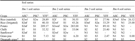 | |
| 1ASC: Actual Suitability Class; 2PSC: Potential Suitability Class; 3YFF: Yield in Farmers Field (q ha-1); *: Newly introduced crop, | |
Note: f, n and w represents soil limiting factors where f denotes limitation in soil fertility (organic carbon), n denotes soil salinity and w denotes soil wetness factor. Potential suitability class was determined on the basis of improvement that can be brought about in the suitability class, after the correction of manageable soil limiting factors viz. fertility and soil salinity
| Table 8: | Comparative analysis of the yield and economics of different rice based cropping sequences in the trial plots |
 | |
highly suitable, otherwise less suitable (moderate, marginal) and even not suitable depending upon the deviation of the soil properties from the optimal growth requirement of the crop (Vadivelu et al., 2004). Soil site suitability evaluation revealed that chilli, grass pea and Dinanath grass were highly suitable in Jbn 1 soil series where as rice, potato and sunflower were moderately suitable in these soils. Soils of Jbn 2 soil series were highly suitable for the cultivation of chilli and Dinanath grass however rice (rainfed and irrigated) may also be grown successfully in these soils after correction of soil fertility. Evaluation study indicated that rainfed rice, chilli and Dinanath grass were moderately suitable in Jbn 3 soil series while soils of Jbn 4 soil series offered limited scope for crop cultivation due to severe limitations of soil salinity and very poor drainage (Seal et al., 2005).
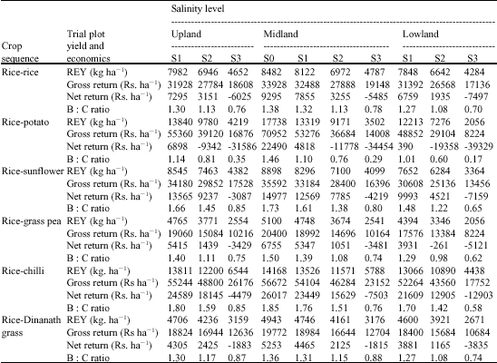
Yield and Economics of Rice Based Cropping Sequences in Different Salinity Level
Average productivity of difference cropping sequences varied with soil salinity level and the production efficiency went down with increase in salinity. In general rainfed rice-chilli cropping sequence recorded the highest productivity (average rice equivalent yield 10,600 kg ha-1) with few exceptions (Table 8). Rainfed rice-equivalent yield of rice-potato cropping sequence was highest in comparison to the other cropping sequences in the non saline and slightly saline soils. However net income was highest from rainfed rice-chilli cropping sequence except in the non saline soils. Hence in non saline and slightly saline soils all the cropping sequences were profitable in terms of net return and benefit cost ratio however in these soils rainfed rice-chilli and rainfed rice-potato was distinctly better than others. Capital investment was much higher for rainfed rice-potato (48,462 Indian rupees ha-1) and rainfed rice-chilli (30,655 Indian rupees ha-1) sequences and therefore most suited for small farmers with better economic status. On the other hand cost of cultivation for rainfed rice-sunflower (20615 Indian rupees ha-1) cropping sequence was much lower while the income per rupees invested (1.66 to 1.22 except in strongly saline soils) was compatible, even higher in some cases than the other cropping sequences rendering it suitable for the resource poor marginal farmers. Similar interpretation was made by Gangwar and Katyal (2001) working on different rice based cropping sequences in West Bengal and Orissa. On similar basis rainfed rice-chilli and rainfed rice- sunflower may be the first choice of small and marginal farmers respectively in the moderately saline soils. In the strongly saline soils, no cropping sequence proved to be profitable, however rainfed rice-Dinanath grass (labour cost was 64.5% of total cost) or rainfed rice-fallow (labour cost was 77.2% of total cost) cropping sequence may be applicable in limited cases as family members contributed a considerable portion of the farm labour, which may curtail the total cost of cultivation.
Land Use Planning
Land use planning at village level indicates the use of agriculture lands to best suited crops and permanent fallow land to other economic uses. Based on land features, soil resources, irrigation facility, land holding size, economic status of farmers, social acceptability and local market demand (Das et al., 2006), crop plan was formulated for successful agriculture in the study area. Especially in coastal region sustainability of soil and water resources are associated with suggested crop planning as these areas suffered from restricted availability of good quality of cultivable land and irrigation water due to salinity hazards.
Suggested Land Use for Marginal Farmers
Suggested land use for marginal farmers aims at maximum utilization of land and water resources without deteriorating soil health and creating maximum mandays of employment in agriculture (Das et al., 2005). Rainfed rice may be cultivated in monsoon season without choice to fulfill the requirement for family consumption. However, in the winter season sunflower and grass pea were suggested as alternate crops in non saline, slightly saline and moderately saline soils of upland and midland. Chilli was not suggested for marginal farmers due to the comparatively high cost (20,160 Indian rupees ha-1) of cultivation. Grass pea cultivation was suited for the marginal farmers due to its low cultivation cost (3,150 Indian rupees ha-1) and was suggested in slightly saline/moderately saline soils of upland and non-saline/slightly saline soils of midland areas. In addition grass pea may be cultivated as utera crop after rainfed rice utilizing the residual soil moisture in the areas where irrigation facility is not available. Large scale potato cultivation may not be suggested for marginal farmers due to high cultivation cost (37,967 Indian rupees ha-1) involved as well as risk and uncertainty associated with potato yield in saline soils, however small scale cultivation may be cultivated in the non saline soils of midland to cater for family consumption. In moderate saline soil sunflower and in lowland condition winter rice cultivation may be suggested with assured irrigation. Adoption of the suggested cropping sequences may increase the operational land holdings size up to 26.32% (Table 9).
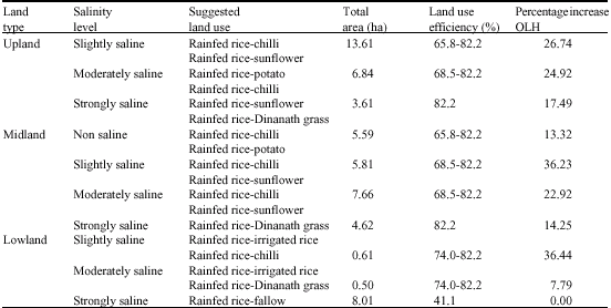
Suggested Land Use for Small Farmers
Rainfed rice cultivation, which forms staple food of the locals is the only choice during monsoon season, however during winter season chilli, sunflower and potato cultivation may be practiced by the small farmers in non-saline and slightly saline soils of upland and midland. Though the net profit of potato was quite lower than that of sunflower in slightly saline soil, its inclusion as winter crops was solely in view of its wide social acceptability. In moderately saline soils chilli could be the first choice due to its higher net income. In strongly saline soils, no crop seemed to be profitable from economic point of view, but rainfed rice-Dinanath grass cropping sequence may be suggested in limited areas where irrigation was assured, considering involvement of family labour (labour cost was 64.5 of total cost) which curtailed the actual cultivation cost in farmers field. Inclusion of fodder crop (Dinanath grass) in the suggested cropping sequence for small farmers was in view of higher status of household livestock, which cost a shortfall in terms of actual fodder requirement. Adoption of suggested cropping sequences by small farmers may increase operational land holdings size up to 36.44% in slightly saline soils of lowland (Table 10).
| Table 9: | Suggested land use of the study area for marginal farmers |
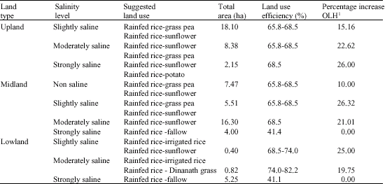 | |
| OLH1 : Operational land holdings | |
| Table 10: | Suggested land use of the study area for small farmers |
 | |
ACKNOWLEDGMENT
The authors are thankful to Indian Council of Agricultural Research, National Agricultural Technology Project for providing funds to carry out the research work.
REFERENCES
- Das, T.H., D. Sarkar and R. Bera, 2005. Resource appraisal of Damodar catchment (part) in Barddhaman district, West Bengal. Agropedology, 15: 39-50.
Direct Link - Das, T.H., D. Sarkar, K.S. Gajbhiye and R. Bera, 2006. Use of natural resource data for suggesting alternate land use plan in Vindhyan Alluvial Plain: A case study in Syamsundarpur village, Bardhaman district, West Bengal. Procceding of the11th West Bengal State Science and Technology Congress, 28 February-1 March, Kolkata, West Bengal, India.
- Gangwar, B. and V. Katyal, 2001. Productivity, stability and profitability of rice (Oryza sativa)-based crop sequences in West Bengal and Orissa. Ind. J. Agron., 46: 387-394.
Direct Link - Jackson, M.L., 1973. Soil Chemical Analysis. 1st Edn., Prentice Hall Ltd., New Delhi, India, Pages: 498.
Direct Link - Kumar, R.S.C., M. Velayutham, G.R. Chary, J. Prasad, P. Chandran and A.D. Rao, 1997. Socio-economic Impact of Land Resource Management on Farming Community: A Case Study of Songi Watershed. In: Social Science Perspectives in Agriculture, Dasgupta, D. and S.D. Mukhopadhyay (Eds.). Visva Bharati University, India.