
Srijana Poudel
Kathmandu Forestry College, Kathmandu, Nepal
Ram Asheshwar Mandal
School of Environmental Science and Management, Kathmandu, Nepal
LiveDNA: 977.18813


ABSTRACT
Background and Objective: Spatial dynamics in watershed is the key indicator of changes in beauty of Phewa lake, but such study is very limited so far done in Nepal. Therefore, this research was objectively conducted to assess the land use and land cover dynamics, explore the causes of land use land cover change and find the potential change in Phewa lake watershed. Materials and Methods: The satellite images of Landsat 7 ETM+ and Landsat 8 OLI/TIRS of 2005 and 2018, respectively were downloaded from United States Geological Survey (USGS). The normalized difference vegetation index (NDVI), normalized difference water index (NDWI) and normalized difference building index (NDBI) were calculated to prepare thematic maps using the support vector machine classification algorithm. Results: The result revealed that 7273.71, 6978.51, 1396.35, 407.43 and 349.29 ha were under forest, agriculture land, built up area, water body and degraded land respectively in 2005 with overall accuracy for 90.12% and kappa coefficient 0.86 whereas the classified image of 2018 showed that 8693.01, 4569.39, 2691.27, 401.94 and 49.68 ha were under forest, agriculture, built up, water body and degraded land respectively. The change detection matrix indicated that the highest land change was noticed from agriculture land to forest area (4.67%) and from agriculture to build up area (3.56%). Conclusion: Similarly, barren area (33.79 ha) near Phewa lake seems to be higher potential for encroachment and more than 40 ha agriculture land might be converted into build up area. The research findings will be useful for policy makers and scientific communities.
PDF Abstract XML References Citation
Received: August 09, 2019;
Accepted: November 20, 2019;
Published: January 30, 2020
How to cite this article
Srijana Poudel and Ram Asheshwar Mandal, 2020. Spatial Analysis of Phewa Lake Watershed of Kaski District, Nepal. Ecologia, 10: 78-85.
DOI: 10.3923/ecologia.2020.78.85
URL: https://scialert.net/abstract/?doi=ecologia.2020.78.85
DOI: 10.3923/ecologia.2020.78.85
URL: https://scialert.net/abstract/?doi=ecologia.2020.78.85
INTRODUCTION
Land-use land-cover are two different terms which are frequently used interchangeably but their actual meanings are distinct1. Specifically, land use is the use of landscape by the people for socio-economic purpose which is used to explain the functional dimension of land while land cover (LC) refers to the physical condition of the earth surface, which includes vegetation, water, soil including physical features of the land. Besides, land cover changes provide the better understanding of relationships and interactions between humans and the natural environment2,3. The assessment of land use patterns and their changes at the watershed level is pivotal for the management of water resources and planning of land use of a watershed4.
The Geographical information system (GIS) and remote sensing (RS) together have been used to monitor and detect the land use land cover dynamics which is easier and faster technology and more reliable than the traditional method of inventory5. Therefore, the application of remotely sensed technique is considered as less time consuming, cost effective and more precise in research field and applied to show the spatial and temporal effect on features of earth surface including water body6-8. At the same time, the result from traditional inventory method sometime may be questionable due to insufficient number of sample but there is less chance of uncertainty in remotely sensed image in fact9. Land use land cover (LULC) change is a dynamic and continuous process which causes major environmental changes globally10 so, it has been considered as an important research field for environmental monitoring researchers, planners, geographers and for policy makers8. Land use land cover change refers to quantitative change in the area (increase or decrease) of a given type of land use or land cover whereas, change detection is a process of extracting, analyzing and defining change information from remote sensing imageries11,12.
Phewa lake watershed is one of the prominent tourist destinations of the western region of Nepal, which consist of forest (49%), agriculture (41%), water bodies and swamp land (5%), built-up areas (3%) and sand (1%)13. Built-up and agricultural lands occupy most of the flat and gently sloped area and forests account for all the remaining land of the watershed14,15. Historical land use land cover pattern provides valuable information for the evaluation of complex causes and responses in order to predict future trends of land use land cover dynamics. People believed that, Phewa lake in Kaski district, Nepal is one of the famous natural pond where millions of tourist come to visit and watch the beautiful view of shade of Fishtail Himalaya seen in the lake16. The shade of Fishtail Himalaya adds the extra lure, peace and joy to visitors. It is fact that, Phewa lake is fed by Phewa watershed. So, any change in land use and land cover in the watershed, there will be obvious effect on the lake and its beauty. In this context, research related to the spatial and temporal dynamics of Phewa watershed is not so far conducted in Nepal. Thus, this study was essential to assess the dynamics of land use and land cover of Phewa watershed between 20005 and 2018 using multispectral image analysis.
MATERIALS AND METHODS
Study area: Phewa watershed was selected as a study site for this study. This research project was conducted from 2017-2018. This watershed lies in the Mahabharat Range in Kaski district of Nepal, the western part of Pokhara Valley. The watershed is geographical situated at 28°11 to 28°11 N and 84.11° to 84.18°E. The boundary of watershed was delineated from Google Earth consulting with the expert. Aster Global Dem was downloaded from Earth Explorer in order to delineate a watershed boundary of a study area. It covers about 120 km2 with its east west average length of 17 km and width of 7 km on average. Lake area itself covers 4.55 km2. The watershed belongs to a semi-agricultural watershed in the mid-hill belt (789-2508 m above msl) of mountain ecosystem14,15. The area of the watershed was estimated to 164.07 km2 which includes both upstream and downstream area of the watershed. The mean annual temperature of the area is 18°C and average annual rainfall is around 4500 m. The forest in the watershed area is mostly dominated by broad-leaved mixed hardwood species (Fig. 1).
Spatial data acquisition: Landsat 7 ETM of 2005 and Landsat 8 OLI/TIRS of 2018 and Aster Global DEM version 2.0 were used as main sources of spatial information about study area. The cloud free Landsat images were downloaded from United State Geological Survey (USGS:https://www.usgs.gov). The path and row of images of Nepal are 142 and 40 respectively. The images were Geo-referenced and projected in Universal Transverse Mercator (UTM) using WGS 1984 with UTM Zone 45 and then images were visualized with Red, Green and Blue color composite.
Key informant interview: Key informant interview was conducted to understand people’s perception about the trend of land change with stakeholders who have been living vicinity of Pokhara watershed since long time and also working in Nepal Tourism Board, woman group, Hotel and Business and Phewa lake Boat association.
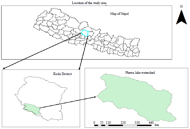 | |
| Fig. 1: | Map of the study area |
Source: Survey Department, 2018 | |
Total 35 key informants were interviewed using structured and semi-structured questionnaire to know the causes of land use land cover change and also potential land use and land cover change.
Digital image pre-processing: The radiometric and atmospheric correction were performed using FLAASH setting available in ENVI 5.3 in order to improve the fidelity of the brightness value17,18.
Importantly, three indices namely normalized difference vegetation index (NDVI), normalized difference water index (NDWI) and normalized difference built-up index (NDBI) were applied for further classification of image19.
The normalized difference vegetation index (NDVI) is most commonly used to differentiate vegetation from other features20. The index was calculated using following equation:
![]()
NIR is near infra red radiance and visible green light by eliminating the presence of soil and terrestrial vegetation features21. The NDWI was estimated using following equation21:
![]()
where, Green and NIR are the reflectance of green and NIR bands, respectively.
The normalized difference built-up index (NDBI) is useful for mapping urban built up areas. It was calculated to differentiate built up area from other features using following equation22:
![]()
where, SWIR and NIR are the reflectance of SWIR and NIR bands, respectively.
Single multispectral image file was prepared from NDVI, NDWI and NDBI images and multispectral band image applying layer stacking tool. Next to this, mask function was produced to make layer of study area for further thematic classification.
Image classification: Supervised classification method with support vector machine (SVM) was applied to classify image into forest, water body, agriculture land, built-up areas and degraded land23.So, training sample i.e., region of interest (ROI) was used for classification of the image. The selected region of interest guides the software to classify the pixels into specified themes based on maximum likelihood.
Accuracy assessment: Accuracy assessment is an important part of a thematic classification which was evaluated using confusion matrix. The accuracy assessment was done using the validation ROI by running confusion matrix tool using Ground Truth ROI for map of 2005. Likewise, accuracy of classified map 2018 was evaluated using the 100 GPS point data that was taken from the field and with Google earth as well.
Change detection: In fact, two independent thematic raster maps were created with a common set of classes. The change matrices according to land use and land cove class were obtained from thematic change work flow and change detection statistics between 2005 and 2018. Maps of 2005 and 2018 were selected as time 1 time 2, respectively to visualize the changes in the map clearly. Finally, three distinct output files were created thematic change image, thematic change vector file and thematic change statistics in particular.
RESULTS
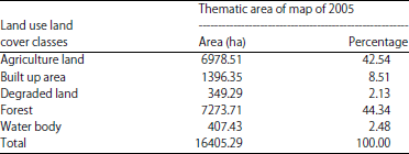
Land use land cover status of 2005 of Phewa lake watershed: The classified map of 2005, revealed that about 44.34% (7273.71 ha), 42.54% (6978.51 ha) 8.51% (1396.35) and 2.13% (349.29 ha) and 2.48% (407.43 ha) areas were under forest cover, agriculture land, water body, degraded land and built up area respectively (Table1, Fig. 2).
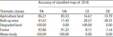
Accuracy assessment of classified map of 2005 of Phewa lake watershed: The overall accuracy for 2005 was 90.12% with kappa coefficient 0.86 which means there was 86% better agreement than by chance alone in 2005. Specifically producer’s accuracy (PA), user’s accuracy (UA), Commission errors (CE) and omission errors (OE) are presented in Table 2.
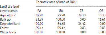
Land use land cover status of 2018: The classified map of 2018 of Phewa watershed was found that 52.95% (8693.01) was under forest cover which was the highest land while it was the lowest only 0.3% (49.68 ha) under degraded land (Table 3, Fig. 3).
Accuracy assessment of the classified map of 2018: The overall accuracy of classified map of 2018 was 85% with kappa coefficient 0.75, therefore there was 75% better agreement than by chance alone in classified map of 2018 (Table 4).
| Table 1: | Change area in Phewa lake watershed in 2005 |
 | |
| Table 2: | Summary of accuracy assessment of classified map of 2005 |
 | |
| Table 3: | Change area in Phewa lake watershed in 2018 |
 | |
| Table 4: | Summary of classification accuracies (%) for 2018 |
 | |
| Table 5: | Thematic change statistics: from to change matrices (2005 and 2018) |
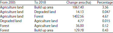 | |
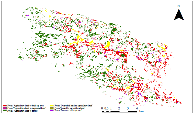
Change detection of land use land cover between 2005 and 2018: The result showed that the highest land cover change was estimated from agriculture land to forest cover (4.67%) which was followed by land use class change from agriculture to build up area (3.56%) between 2005 and 2018 (Fig. 4, Table 5).
Potential land use land cover change of Phewa lake watershed: The anthropogenic activities particularly unplanned road constructions which causes landslides during monsoon, inappropriate planning and settlements and hotel, migration are affecting the beauty of the Phewa lake.
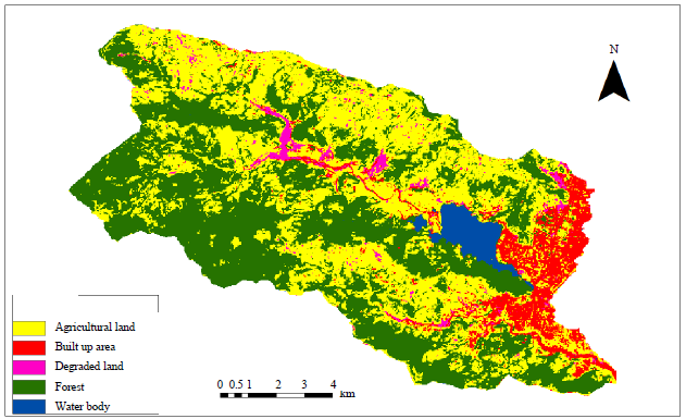 | |
| Fig. 2: | Land-use land-cover map of Phewa lake watershed (2005) |
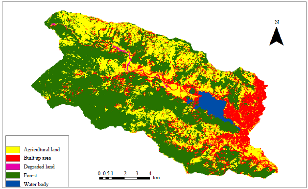 | |
| Fig. 3: | Land use land cover map of Phewa lake watershed (2018) |
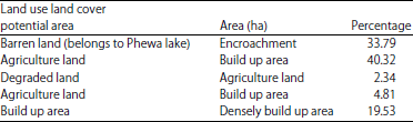
In fact, the barren area (33.79 ha) nearby Phewa lake likely to be encroached for built up purpose. Likewise, the agriculture land of area (40.32 ha) might be converted to build up area in near future. The land which is degraded now (2.34 ha) might be converted to agriculture land by considering the soil conservation measures (Fig. 5, Table 6).
 | |
| Fig. 4: | Change detection map (2005 and 2018) of Phewa lake watershed |
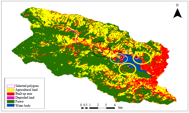 | |
| Fig. 5: | Map showing potential land use and land cover change |
| Table 6: | Potential land use land cover change of Phew lake watershed (2018) |
 | |
DISCUSSION
Remote Sensing and GIS tools have been combined to detect and address land use land cover dynamics of Phewa lake watershed during the period between 2005 and 2018. The change statistics in land use and land cover was varied in different period. The key issue was increase in built up area from different land use. This will be continued in future too as Pokhara is attractive tourist destination. Specifically, built up area was 8.51% in 2005 which was inclined up to 16.4% of total watershed area of Phewa watershed in 2018, in fact it was almost double increase since 2005.
There might be many reasons behind this but most reliable one is increasing population and tourism business as well. Specifically, the population of Pokhara was about 193,000 which is around 600,000 now24,25. Similarly, the tourists were around over 50,000 in 2018 which was only around 10,000 in Pokhara, in fact. These are the evidence of land use change in Pokhara valley26. Urban growth rate of Pokhara between 2010 and 2015 was 5.21%27. Moreover, Pokhara is the largest city of central hill which has been growing rapidly in Nepal28,29. These statements strongly justify our finding that the conversion from agriculture land into build up area as the major changes detected between 2005 and 2018.
On the other, there was positive change in forest cover especially from agriculture land30. In fact, most of the rural people have been migrated permanently of shifted temporarily to urban areas to find easy access in facilities like education, medicine, job and others31. So, the most of agriculture land has been becoming abandoned and later these areas have been converted into agriculture land32,33. Same phenomenon was assessed in our study, since the agriculture land was significantly converted into forest area. Moreover, extension in built up area from agriculture areas were another important base of land use change.
Besides, these changes, there were decreased in water body, the reason might be the siltation and erosion at upstream of Phewa watershed. Similar dynamics were found in several studies around the Phewa lake15,34. A part from these, another important research showed that forest cover and built-up areas were significantly increased whereas agriculture and degraded land were decreased in Phewa watershed, but water body was decreased in the study site35. Proper land use planning is essential for Phewa watershed management prior to any developmental work. The similar option of watershed management was suggested4.
CONCLUSION AND FUTURE RECOMMENDATION
Multi temporal satellite imagery plays a vital role to detect changes in Phewa lake watershed more precisely. The agriculture land and degraded land were converted into build up area because of population growth. The forest cover was increased in 2018. Moreover, there are some potential changes like agriculture to build up as well as encroachment of barren area. Future studies are recommended on evaluation of driving forces of land use land cover change in Phewa lake watershed.
SIGNIFICANCE STATEMENT
This study discovered the agriculture land and degraded land in Phewa Lake converted into build up setup and affects the beauty of Phewa lake site. This research will be useful to find the appropriate option to manage the tourist place like Pokhara lake and its watershed.
ACKNOWLEDGMENT
We heartily acknowledge Principal of Kathmandu Forestry College Professor Ambika Prasad Gautam and Coordinator Mr. Arun Sharma Paudel for their encouraging support.
REFERENCES
- Dimyati, M., K. Mizuno, S. Kobayashi and T. Kitamura, 1996. An analysis of land use/cover change in Indonesia. Int. J. Remote Sens., 17: 931-944.
CrossRefDirect Link - Halefom, A., A. Teshome, E. Sisay and I. Ahmad, 2018. Dynamics of land use and land cover change using remote sensing and gis: A case study of debre tabor Town, South Gondar, Ethiopia. J. Geog. Inform. Syst., 10: 165-174.
CrossRefDirect Link - Fichera, C.R., G. Modica and M. Pollino, 2012. Land cover classification and change-detection analysis using multi-temporal remote sensed imagery and landscape metrics. Eur. J. Remote Sens., 45: 1-18.
CrossRefDirect Link - Butt, A., R. Shabbir, S.S. Ahmad and N. Aziz, 2015. Land use change mapping and analysis using remote sensing and GIS: A case study of Simly watershed, Islamabad, Pakistan. Egypt. J. Remote Sens. Space Sci., 18: 251-259.
CrossRefDirect Link - Dewan, A.M. and Y. Yamaguchi, 2009. Using remote sensing and GIS to detect and monitor land use and land cover change in Dhaka metropolitan of Bangladesh during 1960-2005. Environ. Monit. Assess., 150: 237-349.
CrossRefPubMedDirect Link - Beckerman, W., 1992. Economic growth and the environment: Whose growth? Whose environment?. World Dev., 20: 481-496.
Direct Link - Steininger, M.K., 1996. Tropical secondary forest regrowth in the Amazon: Age, area and change estimation with Thematic Mapper data. Int. J. Remote Sens., 17: 9-27.
CrossRefDirect Link - Zhu, G., Z. Tang, Z. Shangguan, C. Peng and L. Deng, 2019. Factors affecting the spatial and temporal variations in soil erodibility of China. J. Geophys. Res.: Earth Surface, 124: 737-749.
CrossRefDirect Link - Bergseng, E., H.O. Ørka, E. Næsset and T. Gobakken, 2015. Assessing forest inventory information obtained from different inventory approaches and remote sensing data sources. Ann. For. Sci., 72: 33-45.
CrossRefDirect Link - Schmidt, J.J., E. Piras and W. Gordon, 2012. Environmental social science: Human-environment interactions and sustainability. Int. J. Social Res. Methodol., 15: 445-450.
CrossRefDirect Link - Xiaolu, S. and C. Bo, 2011. Change detection using change vector analysis from Landsat TM images in Wuhan. Procedia Environ. Sci., 11: 238-244.
CrossRefDirect Link - Zewdu, S., K.V. Suryabhagavan and M. Balakrishnan, 2016. Land-use/land-cover dynamics in sego irrigation farm, Southern Ethiopia: A comparison of temporal soil salinization using geospatial tools. J. Saudi Soc. Agric. Sci., 15: 91-97.
CrossRefDirect Link - Fleming, B. and J.P. Fleming, 2009. A watershed conservation success story in Nepal: Land use changes over 30 years. Waterlines, 28: 29-46.
CrossRefDirect Link - Regmi, R.R., S.K. Saha and M.K. Balla, 2014. Geospatial analysis of land use land cover change modeling at Phewa lake watershed of Nepal by using cellular automata Markov model. Int. J. Curr. Eng. Technol., 4: 260-267.
Direct Link - Regmi, R.R. and S.K. Saha, 2015. Impact assessment of land use land cover change on soil erosion status in Phewa lake watershed of Nepal. Int. J. Curr. Eng. Technol., 5: 1708-1717.
Direct Link - Heyojoo, B.P. and P. Takhachhe, 2014. An assessment of lake area shrinkage through geospatial approach: Case study of Phewa Lake of Kaski district, Nepal. Int. J. Multidiscipl. Curr. Res., 2: 725-728.
Direct Link - Haque, M.I. and R. Basak, 2017. Land cover change detection using GIS and remote sensing techniques: A spatio-temporal study on Tanguar Haor, Sunamganj, Bangladesh. Egypt. J. Remote Sens. Space Sci., 20: 251-263.
CrossRefDirect Link - Bhatti, S.S. and N.K. Tripathi, 2014. Built-up area extraction using Landsat 8 OLI imagery. GISci. Remote Sens., 51: 445-467.
CrossRefDirect Link - Kumar, K.S., P.U. Bhaskar and K. Padmakumari, 2012. Estimation of land surface temperature to study urban heat island effect using Landsat ETM+ image. Int. J. Eng. Sci. Technol., 4: 771-778.
Direct Link - McFeeters, S.K., 1996. The use of the Normalized Difference Water Index (NDWI) in the delineation of open water features. Int. J. Remote Sens., 17: 1425-1432.
CrossRefDirect Link - Zha, Y., J. Gao and S. Ni, 2003. Use of normalized difference built-up index in automatically mapping urban areas from TM imagery. Int. J. Remote Sens., 24: 583-594.
CrossRefDirect Link - Huang, C., L.S. Davis and J.R.G. Townshed, 2002. An assessment of support vector machines for land cover classification. Int. J. Remote Sens., 23: 725-749.
CrossRefDirect Link - Rimal, B., 2011. Urban growth and land use/land cover change of Pokhara Sub-metropolitan city, Nepal. J. Theor. Applied Inform. Technol., 26: 118-129.
Direct Link - Tuladhar, A.R., 2019. Remote sensing of Nepal’s forests and trees: Ascertaining the front line of human-induced tree cover change. Nepalese J. Geoinform., 18: 1-14.
Direct Link - Paudyal, K., H. Baral, L. Putzel, H. Bhandari and R.J. Keenan, 2017. Change in land use and ecosystem services delivery from community-based forest landscape restoration in the Phewa Lake watershed, Nepal. Int. For. Rev., 19: 88-101.
Direct Link