
Nidhi Nagabhatla
Said Business School (Chevening Scholar 2011), University of Oxford, Oxford, United Kingdom
Shalini Dhyani
G.B. Pant Institute of Himalayan Environment and Development, Almora, India
C. Max Finlayson
Institute for Land, Water and Society, Charles Sturt University, P.O. Box 789, Albury, NSW 2640, Australia
Sonali Senaratna Sellamuttu
International Water Management Institute (CGIAR), Laos
Martin Van Brakel
Challenge Program of Water and Food (CPWF), Sri Lanka
Rohan Wickramasuriya
Geo QuEST Research Centre, School of Earth and Environmental Sciences, University of Wollongong, Wollongong, NSW, Australia
Chiranjibi Pattanaik
Salim Ali Centre for Ornithology and Natural History (Ministry of Environment and Forests, Govt. of India), Hyderabad Andhra Pradesh, India
S. Narendra Prasad
Salim Ali Centre for Ornithology and Natural History (Ministry of Environment and Forests, Govt. of India), Hyderabad Andhra Pradesh, India


ABSTRACT
Effective implementation of participatory environmental governance faces a number of challenges, including the need for appropriate mechanisms and incentive systems that can operate across multiple-use landscapes. This study demonstrated scenarios for such governance from three agro-ecological zones in different geographical, biophysical and socio-cultural settings: (i) Kedarnath Wildlife Sanctuary in the temperate forests of the Central Himalayas, (ii) Kolleru Lake, a freshwater lake in the Krishna Basin and (iii) the downstream Ganges seasonal floodplains in Bangladesh. The cross-disciplinary set of approaches in these examples involves the use of spatial tools and socioeconomic surveys to build a scenario-based framework with cross-scaling prospects. The comparative analysis between these sites is significant in the context of providing guidance for trans-boundary environmental governance and the underlying challenges that occur in politically complex and common property resource institutional arrangements. Meeting these challenges will assist in the efforts, locally and nationally, to make wise use of all wetlands, as required under the Ramsar Convention on Wetlands. Kedarnath Wildlife Sanctuary symbolizes a case of increasing anthropogenic pressure, limited livelihood options and with gaps in the governance structure. Kolleru Lake represents a case of inadequate understanding of the ecological dimensions of livelihood interventions and the consequential community conflict. The case of floodplains in Bangladesh illustrates the potential of collective action, supported by appropriate institutional arrangements, for improving rice-fish productivity. The case studies support the argument that monitoring and assessment of the resource structure and its dynamics, with the application of geospatial tools, adds value when shaping a framework for policy debate and for ensuring the wise use of wetlands.
PDF Abstract XML References Citation
Received: November 03, 2011;
Accepted: February 16, 2012;
Published: May 22, 2012
How to cite this article
Nidhi Nagabhatla, Shalini Dhyani, C. Max Finlayson, Sonali Senaratna Sellamuttu, Martin Van Brakel, Rohan Wickramasuriya, Chiranjibi Pattanaik and S. Narendra Prasad, 2012. A Case Study Approach to Demonstrate the Use of Assessment and Monitoring as Tools for Participatory Environmental Governance. Ecologia, 2: 60-75.
DOI: 10.3923/ecologia.2012.60.75
URL: https://scialert.net/abstract/?doi=ecologia.2012.60.75
DOI: 10.3923/ecologia.2012.60.75
URL: https://scialert.net/abstract/?doi=ecologia.2012.60.75
INTRODUCTION
The congruence of an economically-oriented political system and sector-based interventions for natural resource management has increasingly marginalized many traditional resource use practices and indigenous coping mechanisms (Rennings and Wiggering, 1997). Simultaneously, the cumulative impact of environmental change, including climate change, is leading to distortions in the interaction between resources and their beneficiaries, especially in resource-dependent, subsistence rural communities (Nagabhatla and Sellamuttu, 2008; Osofsky et al., 2005). The incongruous nature of such interactions has created conflict between resource managers and users and poses severe difficulties for instituting participatory processes that support effective environmental governance (Bulkeley and Arthur Mol, 2003) and the wise use of wetlands, as required under the Ramsar Convention on Wetlands (Finlayson et al., 2011).
Participatory Environmental Governance (PEG) is an emerging management concept adopted by and employed in many countries to strengthen their governance capacities through collaborative engagement with non-governmental stakeholders, including NGOs, social communities, the private sector, as well as research and academic institutions (UNITAR, 2011). Advocates of PEG recognize that democratic, environmental management is achievable if diverse ecological and socio-economic circumstances are addressed, existing management gaps identified and capacity development for stakeholders is treated as a priority. In addition, it should take into account national development goals and international obligations for sustainable development, such as the wise use of wetlands (Yilmaz and Yildiz, 2005; Finlayson et al., 2011).
The theory of PEG symbolizes the essence of ‘Principle 10’ adopted at the Rio (United Nations Conference on Environment and Development-UNCED 1992 Summit, namely, to strengthen stakeholder participation in environmental decision-making via three main components: access to information, public participation and access to justice (Barber, 2003; Newig et al., 2007). It also supports the wise use of wetlands as espoused under the Ramsar Convention since 1971 (Finlayson et al., 2011). Many years after the Ramsar Convention was signed and after the Rio Summit this approach was highlighted in the Millennium Ecosystem Assessment (MEA 2005), described as Ecosystem Based Management which comprises a framework to manage multiple services and benefits of natural resources to achieve ecological sustainability, socioeconomic stability and economic progress (Nagabhatla et al., 2011; Kathiresan and Alikunhi, 2011). These concepts sit alongside, livelihood security, food production and sustainable management of natural resources, as recognized in the Millennium Development Goals (MDG) (http://www.un.org/millenniumgoals) and are implicitly contained in current guidance produced by the Ramsar convention for the wise use of wetlands (Finlayson et al., 2011).
In more recent times, development interventions intended to address the MDG goals are witnessing a shift from a single objective, centralized conventional mode of decision-making, to decision-making in a collective fashion that promises to support the involvement of multi-level stakeholders and their needs. Lemos and Agrawal (2006) questioned, whether defining and measuring development via participatory, multi-objective approaches can capture the complexity of interactions between resource and human dynamics? Whelan and Oliver (2005) argue that there are considerable benefits in coupling the sustenance of social and natural systems in cases where suitable investments are made to strengthen the capacity of stakeholder groups.
The evolving paradigm of PEG emphasises the need for open discussions with a wider range of stakeholders, improved understanding of environmental value, gender equity and promotion of co-management and collective action to manage natural resources with policy support, suitable institutional arrangements and initiatives such as public private partnerships that promise to contribute towards its effective implementation and are of great relevance for its sustainability (Macrory and Turner, 2002; Neef, 2009).
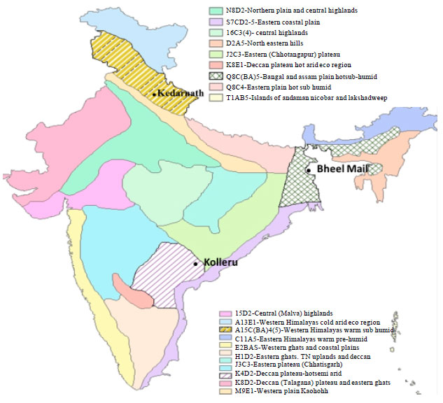 | |
| Fig. 1: | Location of case sites: representative of three agro-ecological zones of India |
Attempts to develop collective decision-making, as reported from multiple resource sectors viz., forestry (Maskey et al., 2006), water management (Le Grusse et al., 2006), fisheries (Ahmed et al., 1997) and aquaculture (Mustafa and Brooks, 2009) and more recently in climate change adaptation dialogue (Adger, 2003), have taken a big step forward. At the same time, issues about the costs and benefits (Iqbal, 2005), traditional rights (Misra et al., 2009), policy and institutional support (Nagabhatla and Sheriff, 2011) and community conflict still pose challenges that may need careful maneuvering for successful implementation and compliance of the PEG framework.
In this study we record and analyse observations about PEG for diverse resource systems in three geographical locations that have different agro-ecological and socio-economic characteristics in India. The biophysical assessment and monitoring of the agro-ecological ecosystems, namely i) the Kedarnath Wild Life Sanctuary, a temperate forest in the Northern Plains of India, ii) a seasonal floodplain in Assam and Bengal catchment (extending to Bangladesh) and iii) Kolleru Lake in the Deccan Plateau and Eastern Ghats agro-ecosystem (Fig. 1), is conducted on the basis of remote sensing images and by using a Geographical Information System (GIS). Using a case study approach, the authors observe and examine the challenges and effort needed to identify gaps in effective implementation of participatory governance. The usefulness of geospatial tools and techniques such as decision support systems and the need for up-to-date information and knowledge exchange, is also emphasized.
MATERIALS AND METHODS
The agro-ecological zones were defined by the National Agricultural Research Project (NARP) and National Bureau of Soil Survey and Land use Planning (NBSS LUP) in 1992 taking into account physiographic, climate, soils and agricultural properties of the landscape. The 20 agro-ecological regions that were identified were further divided into sixty sub-regions and are regularly used by the federal agencies of India for decision making on natural resource management (Subramanium, 1983). This background explains the attributes of the selected agro-ecological zones that are described in Table 1.
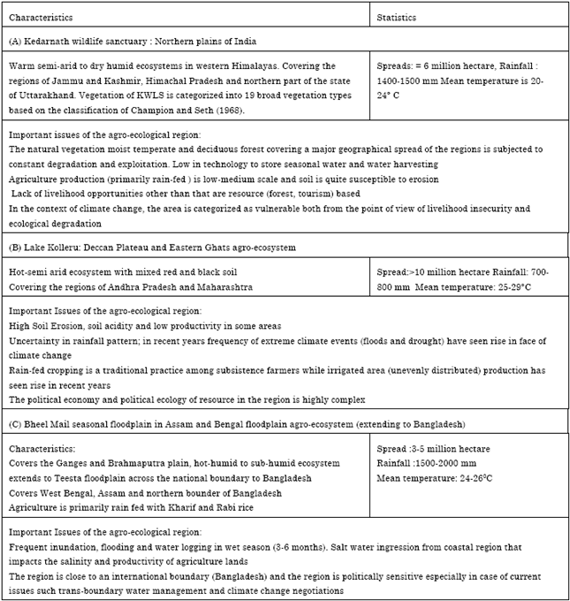
Case study 1: Temperate forest in central Himalayas zone: This study considered the current status and existing gaps in conservation and management of the Kedarnath Wild Life Sanctuary (KWLS), a globally important conservation area, based on a detailed review of biophysical values and evaluation of the sanctuary’s conservation status with stakeholders in order to re-define priorities and biodiversity attributes for future conservation planning. A detailed review of forest and land-use policies for the region was conducted using a method employed by Misra et al. (2009) that includes the collection of historical records (from the regional Forest Department), government reports and anecdotal information related to resource rights, management and rural development (available from various institutes and government departments). Information on the demography, settlement patterns and local communities was collected from the office of the Revenue Department, Ukhimath, District Rudraprayag. An evaluation of the infrastructure, manpower and other support systems of the sanctuary management were conducted via available research notes (Kharkwal et al., 2007), discussions and informal interviews with sanctuary officials. Resource rights on forests were verified from village records and in discussion with the elected representatives of the village institutions.
Case study 2: Freshwater ecosystem in the lower Krishna basin: The study of the Kolleru Lake freshwater ecosystem in the lower Krishna Basin was conceptualized by the IWMI wetland program in 2006, with the primary objective to study the land use and livelihood dynamics in context of an undefined protected and common area boundary, unclear policies on resource use and inept institutional arrangements that did not succeed to address the correct threshold in livelihoods need vis-à-vis sustainable resources use (Nagabhatla and Sellamuttu, 2008).
This case study analyzed the post-aquaculture demolition scenario to quantitatively characterize the ecological spectrum and its impact on resource-dependant livelihood opportunities.
| Table 1: | Attributes of the agro-ecological zones representing the case studies |
 | |
We used a combination of socio-economic assessment (2006-2007) and earth observation data (Indian Satellite Series (IRS)-LISS III (for 2007 with a spatial resolution of 23.5 m) integrated in a GIS media to illustrate the changes that occurred in the lake over the past few decades. The spatial observations obtained in this case study were validated with ground reconnaissance and Global Positioning System (GPS).
Case study 3: Seasonal floodplains downstream Ganges basin: We adopted a geospatial approach to characterize the resources of seasonal floodplains in the downstream part of the Ganges, in order to study the suitability of development interventions for fish culture and the potential for out-scaling such an analysis to address issues of livelihood diversification. The temporal analysis (1977, 1989, 2001) was based on freely accessible Landsat earth observation image archives (accessible at www.landsat.org) and was used to illustrate the trend in use of floodplain resources; the increase in agricultural area, fundamentally attributed to basin irrigation development and a concurrent rise in the inundated area attributed to extreme climate events such as floods and cyclones.
RESULTS
Case study 1: Temperate forest in central Himalayas zone: This study considered the current status and existing gaps in conservation and management of the KWLS which covers 96,725 hectares in the Garhwal region, Central Himalaya. Categorised as a ‘Managed Nature Reserve’ using the IUCN criteria for protected areas (IUCN 1994), the region is a bio-geographical extension of the Himalayan highlands with a complex set of climate, geology and topographic attributes (Rodgers and Panwar, 1988). The sanctuary is bounded to the north by several peaks, with altitudes ranging from 1160 to 7068 metres above mean sea level. It is estimated that about 44-49% of the sanctuary is forested, 8% comprises alpine meadows and scrub, 42% is rocky/under permanent snow and 1.5% forested areas that are currently reported as degraded (Prabhakar et al., 2001) (Fig. 2). Agricultural (rain-fed) lands in each settlement can be divided into two identical parts, areas towards hilltops (known as Malla Sari) and areas downslope (Talla Sari).
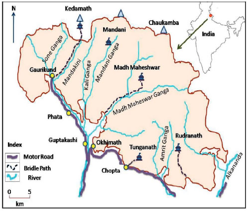 | |
| Fig. 2: | Kedarnath wildlife sanctuary: Location, drainage and landscape features |
KWLS is a home to several endangered plant species, such as Acer caesium and Nardostachys jatamansi, Picrorhiza kurroa and an important habitat for musk deer (Moschus chrysogaster), snow leopard (Panthera uncia) and several Himalayan ungulates.
The synthesis of the discussions with multi-stakeholders unveiled several challenges for the Sanctuary in terms of external threats associated with the irresponsible activities of tourists, infrastructure development and ever-increasing demands for land and water resources by the local inhabitants. Crop damage by wildlife, human and livestock predation by wildlife, lack of appropriate and sufficient infrastructure of the forest department, inaccessibility of the terrain for patrols by forest guards, encroachment of local transhumants and Van Gujjars [also called ‘forest Gujjars’ these are ethnic communities found in the Shivalik hills area of Northern India] inside grazing pastures (Kharak), dependence of locals on forest resources and the poor status of the Reserve Forest (RF) and Community Forest (CF) areas are other factors undermining the process of effective management. Inadequate research and development/policy issues provide additional institutional obstacles for developing an appropriate level of understanding of the sustainable use of resources in the sanctuary.
Socio-historical analyses illustrate that the approach taken to manage Protected Areas (PA) has been isolationist, based on the questionable assumption that we must protect the area from people living in the surrounding areas and shield wildlife and other resources from exploitation. The needs and aspiration of rural people living in and around, the PAs have largely been overlooked when conservation policies have been implemented. Implementation is achieved through strict enforcement of legislation, patrols to prevent illegal activities and infrastructure maintenance. In such a scenario, attempts to protect the PAs from human intervention by coercion have often led to hostile responses from the local people towards wildlife management and forest staff and sometimes to open conflict in parts of the sanctuary. Human dimensions in the sanctuary assume high priority because conservation issues inside PAs cannot be resolved without participation of traditional societies/ethnic groups (Maikhuri et al., 2000, 2001; Rawal and Dhar, 2001; Mirani et al., 2002; Rao et al., 2003; Chandra et al., 2011). This has led to policy planners to focus on the need for people-responsive strategies for conservation in the PA network, resulting in strengthening of the buffer zone concept.
The sanctuary management and administration should be involving local people in planning and decision-making to reduce conflict and to help in conflict resolution with regard to resource extraction. There is also need to promote eco-tourism for economic development of the area. The Sanctuary has rare scenic forests with high ecological, cultural, religious and spiritual values, rich biodiversity and a long history in attracting nature lovers and eco-tourists but the present emphasis is on regular Hindu pilgrimages. The large area of KWLS cannot be properly managed without active participation and involvement of local communities. The application of geospatial techniques provides a visual depiction to facilitate the zoning framework for collective management.
A possible way to reduce the pressure on the biota of the sanctuary requires conservation education through training programmes, capacity building and outreach with respect to sustainable harvesting of natural resources. This emphasizes the need to strengthen community–sanctuary linkages as biodiversity cannot be conserved and protected merely by setting aside chunks of an area as reserves (Deb and Sundriyal, 2005). The case study provides an example to understand the ecosystem based management perspective that links conservation objectives and development goals for livelihood security, poverty reduction and food production.
Case study 2: Freshwater ecosystem in the lower Krishna basin: The Kolleru Lake freshwater ecosystem is a part of the Deccan Plateau and Eastern Ghats agro-ecological system and a vital hydrological component of the Krishna-Godavari delta. Considered, as a fertile agriculture zone and a lifeline for local farmers and fishers, the lake’s catchment spreads along the +10 m contour line. The region within the +5 m contour has been designated as a Wildlife Sanctuary (1999) and a Ramsar wetland of international importance (2002). The study had the primary objective to study the land use and livelihood dynamics in the context of an undefined protected and common area boundary, unclear policies on resource use and inept institutional arrangements that did not succeed in addressing the correct threshold in livelihoods need vis-à-vis sustainable resources use (Nagabhatla and Sellamuttu, 2008). As a result, the land originally allocated to the landless for rice culture in 1970s, slowly and gradually turned to a huge financial resource for the influential business community via the rigorous commercial fish culture that took over subsistence agriculture.
The demolition of the aquaculture structures ordered by the Supreme Court of India in 2006, triggered by protests from the local communities and conservationists had the objective to restore the ecological function of the lake ecosystem. The preliminary decision of the management authorities was to restore resource-based livelihood activities such as paddy cultivation without the use of pesticides and capture fisheries in the lake water; however, inadequate effort was directed towards re-establishing the livelihoods of 46 bed (inside the lake bed) and 76 belt (on the sanctuary boundary) communities with a population of nearly 0.3 million.
The spatial outputs provide visual and statistical understanding on the physical landscape condition in order to build a conceptual framework for the wise administration of the internationally recognised Kolleru Lake wetland ecosystem (Fig. 3a, b). Spatial statistics reveal that before aquaculture demolition nearly half (42%) of the lake bed area was subjected to commercial fish farming controlled by the influential business community of the state of Andhra Pradesh and the adjoining region (Nagabhatla et al., 2009). The image analysis complimented with on-ground observation showed positive signs of regeneration of the natural habitat of the lake, along with the return of migratory bird species that had almost vanished as the natural wetland vegetation of the lake had been destroyed to dig fish ponds (Pattanaik et al., 2008). It was also observed that the fish cultivation area was reduced to 4%; concurrently the marshy areas and the aquatic vegetation represented nearly 48% of the total area coverage of the lake by the end of 2007.
The landscape evaluation following the demolition of the aquaculture revealed prominent gaps in the management framework adopted in the past; the approach that was followed was unsuccessful in engaging with the direct beneficiaries (communities with wetland resource dependant livelihood); a crucial element of the PEG approach.
The role of spatial tools for providing up-to-date and valuable information to facilitate decision making on wetland resource use was highlighted in this case study. For example, the rapid regeneration of breached fish tank beds into natural vegetation with reed and sedges provides promising options for local communities to engage in resource-based livelihoods (such as basket weaving, making reed mats) by making use of the changes in the land cover.
Case study 3: Seasonal floodplains downstream Ganges basin: The floodplains in the alluvial Bangladeshi delta (144,000 km2) of the Padma (Ganges) basin, occupy a significant percent of the country’s productive landmass (Fig. 4). These floodplains are subjected to 4 to 6 months of seasonal inundation which in recent years, has seen a significant increase (Craig et al., 2004; Sabegh et al., 2011). As of result of the annual inundation event, permanent/semi-permanent water bodies (commonly referred as beels and haors) are formed and during that part of the year (wet season) the croplands are unsuitable for producing rice.
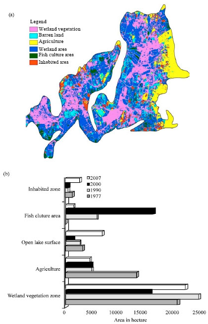 | |
| Fig. 3(a-b): | (a) Spatial analysis Kolleru, representing the image analysis for 2007 and (b) Aerial statistics for major land cover types in the lake ecosystem, the change in trend from 1977-2007 |
In dry months, the lands are used for rice production, serving a common resource property need (Haque et al., 2008).
The representative site, Bheel Mail (Mohanpur Upzilla, Rajashahi District) floodplain lies in the western catchment of the High Ganges (Padma) river floodplain agro-ecosystem and, with a spread of 13,205 km2 it is a continuation of the Assam and Bengal floodplain agro-ecological system across the boundary between India and Bangladesh. Community-based fish culture was introduced to the area to compliment the traditional capture fisheries practice in the inundated croplands, as an adaptation option to support the livelihoods of the community surrounding the floodplain.
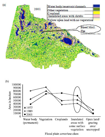 | |
| Fig. 4(a-b): | Spatial landscape analysis, Bheel Mail, Bangladesh: (a) Classified image of the downstream cross-section of Padma basin and (b) Aerial statistics for temporal analysis that reflect the up-scaling potential (marked as circles) |
This case exhibits two significant attributes for the effective implementation of PEG; first the collective approach towards joint decision making, especially in the context of common resource pool and second, monitoring of the impact (likelihood for out scaling) of the intervention from an agro-ecological perspective. The second is significant in terms of resource managers being able to utilize the observations and lesson learnt to scale the approach across the geographical spread of the agro-ecosystem. The success of the intervention is not exclusively dependent on agro-ecological properties with the hydrological properties (including the length and depth of inundation and the drainage pattern), socio-cultural associations (willingness of the communities to join together) and institutional arrangements (leasing of common resource property during the wet season) along with policy support are crucial for calibrating the appropriate models of participatory action along with in-depth congregation of knowledge for wise management of landscape resources (Nagabhatla and Sheriff, 2011).
DISCUSSION
The fundamental challenge for participatory management, as reflected from the above cases, is to deal with the complexity and interrelationship in biophysical characteristics, livelihood diversity, economic opportunities and institutional structures in concurrence. Obtaining the right tradeoffs between conservation and development is at the centre of efforts to ensure the balance that could facilitate or undermine efforts to warrant that participatory governance is effective and wetlands are managed sustainably, or wisely, as per the obligations contained in the text of the Ramsar Convention on Wetlands (Finlayson et al., 2011). Other issues observed during the analysis of the case studies include: widespread lack of understanding of the biophysical attributes and their seasonality; boundary disputes; policy motives that do not reflect a sense of ownership for resource users; and governance structures that do not address resource conservation and community wellbeing in conjunction. To ensure that PEG is effectively instituted and does not inflate expectations it is vital to develop an in-depth scientific understanding of the ecological structure (land use patterns, including seasonality) of the resource of interest integrated with an adequate level of knowledge about the role of and benefit to stakeholders.
The case study approach emphasizes a multi-system, iterative approach to analyze and address the gaps and vulnerabilities and learn from success stories. Learning should be structured to help orient the PEG objectives to support both community resilience and sustainable resource use. Towards this end, a number of methods are discussed; the role of geospatial tools to acquire scientifically up-to-date information that can assist in boundary definition; land use zoning to resolve common property resource related conflicts, especially for seasonally dynamic resource systems such as wetlands; and strengthen access to information and contribute to capacity development in environmental decision-making. Besides, addressing challenges of local governance, an in depth understanding of the above issues can facilitate the setting of priorities and development of an appropriate Action Plan for implementation of the sustainability goals and other international obligations conceptualized before and following the Rio Declaration. The most directly relevant of these, the wise use approach of wetlands, equates with the sustainable development of wetlands and is based around the effective involvement of local communities and technical competency and national policy (Finlayson et al., 2011).
The case studies (Lake Kolleru and Bheel Mail floodplain) demonstrate that in order to stimulate a participatory process, assessment of past trends, identifying existing capacities of local and national resource users and managers complimented with systematically coded information can help re-orient the triangular interaction between science, people and policy, complementing the argument by Backstrand (2003). In addition, addressing opportunities, conflict and trust while working collaboratively with various government sectors and stakeholder groups also contributes to the fulfillment of the goals set by international obligations, such as those under the MDGs and the Ramsar Convention and explored in the Millennium Ecosystem Assessment synthesis of water and wetlands (Finlayson et al., 2005).
Before the 1980s and 1990s, protected area management tended to exclude local communities, revoke customary rights and ban local people from incursions into protected areas. In the case of the forests of Kedarnath Wildlife Sanctuary it is evident that lessons have been learnt and local people are now recognized as comprising an integral part of the conservation area. In the region, conservation practitioners have now developed alternative models for protected area management-these address conflict resolution and integrate livelihoods vulnerability in conservation goals. Similar observations are reported from similar landscape in the neighbouring country of Bangladesh (Karim and Mansor, 2011).
Local development and participation of the local community are essential components of conservation and the wise use of wetlands and are being put into practice in current management procedures. The strong linkages between management of protected areas, local people and economic development and participation are now explicitly advocated. Complementing such initiatives, is the Tribal’s Rights Act (India) 2007 which strongly advocates the recognition of the rights of the rural poor and tribal people on their forests lands. The development of policies and procedures that support the role and rights of local communities is a key component of the wise use of wetlands (Finlayson et al., 2011) and is seen increasingly as a way of integrating the maintenance of livelihoods with wetland conservation, especially in situations where food security abuts water management and conservation objectives (Falkenmark et al., 2007; Gordon et al., 2010).
The case study approach demonstrates the vital role that management of protected areas can play in the conservation and wise use of social, natural and cultural resources, along with their crucial contribution for conserving biodiversity and delivering vital ecosystem services, such as protecting watersheds and soils on which indigenous people depend for their survival. Additionally, the sanctuary area can provide prospective options for rural development, rational use of marginal land, monitoring for conservation education and for recreation and tourism; however, this whole process needs more of a reframing and bottom up approach to skilfully address the issues to ensure PEG is undertaken successfully.
In the Ganges Basin, the upstream region of Kedarnath and downstream floodplain in Bangladesh reflect the active dimension of public participation; this participation is not limited to collectively managing the common property resource but extends to the generation, verification and use of scientific knowledge and decision making in unison with the resource managers. The spatial characterization of landscape resources for Kolleru Lake serves as a decision making tool to embody ecosystem based management in decision making for natural resource management, as well as for policy formulation and implementation of practices that ensure the wise use of the wetland resources. Anbalagan et al. (2012) illustrates the application of spatio-temporal analysis to understand resource dynamics, though in a different context. This approach is seen as being pertinent for seasonally dynamic resource systems such as wetlands, as well as more widely applicable for land and water resource systems such as forests and floodplains.
Bulkeley and Arthur Mol (2003) emphasise that effective partnership between multiple stakeholders and federal managers at multiple-levels is an important aspect of the PEG projects. To this end, the pragmatic analysis from the three case studies explores the extent of the current level of governance and how this reflects the ability of participatory decision-making to deliver outputs for decision making for a structured environmental policy. The case studies demonstrate examples to understand the ecosystem based management perspective that links conservation objectives and development goals to address livelihood security, poverty reduction, food production and climate change and provides tangible support for the policy of wise use of wetlands that has been a long held centerpiece of the Ramsar Convention (Finlayson et al., 2011).
The case studies further demonstrates that varied scenarios can support the implementation of PEG viz., different levels of stakeholder involvement, gaps that can be filled with scientific understanding of resource features, or the role of re-orienting scientific information to ensure it is suitable for knowledge management. We note that the identification of existing gaps can contribute to the ecological, economic policy/institutional and socio-cultural context that support the development of relevant policies and their implementation. Monitoring and assessment via quantitative (spatial analysis) and qualitative (socioeconomic survey) methodological frameworks strengthen the integration of different sectoral requirements (viz., social, ecological, environmental and economical and policy) for PEG. In particular, the case studies illustrate how these approaches can assist in observing and examining the challenges and effort needed to identify gaps in effective implementation of participatory governance. In this respect and based on the examples shown in these investigations, the usefulness of geospatial tools and techniques such as decision support systems and the need for up-to-date information and knowledge exchange, as tools to assist PEG has been shown, although it is recognized that the specific usefulness of these tools will be affected by local circumstances and opportunities.
The adoption of effective mechanisms for PEG can contribute to the wise use of wetlands in India, as is expected as a consequence of India’s involvement in the Ramsar Convention. The implementation of wise use is heavily dependent on effective PEG along with sound technical policy and on-ground management and includes consideration of the trade-offs that occur between the maintenance and exploitation of wetlands, particularly if they are made with the full understanding of their implications for the future and for other sectors, particularly with those communities that are most directly dependent on natural ecosystems (Finlayson et al., 2011). The benefits for governments and society to work much more cross sectorally has been strongly recognised by the Ramsar Convention that “provides a powerful series of messages to decision-makers in the wide range of sectors impinging on wetland and biodiversity conservation, whose future business success depends just as much on healthy wetlands as does the conservation sector.” (Finlayson et al., 2011).
ACKNOWLEDGMENT
This script derives inspiration from a talk presented at the International Workshop on Biodiversity and Climate Change (19-22 December 2010) at the Indian Institute of Technology, Kharagpur, India by the senior author. The talk was entitled Participatory Environmental Governance in Multiple Resource Systems: Perspectives on Biodiversity Conservation, Food Security and Adaptive Capacity. The usual disclaimer applies.
REFERENCES
- Adger, W.N., 2003. Social capital, collective action and adaptation to climate change. Eco. Geog., 79: 387-404.
Direct Link - Ahmed, M., A.D. Capistrano and M. Hossain, 1997. Co-management of Bangladesh fisheries. Fish. Manag. Ecol., 4: 233-248.
CrossRef - Backstrand, K., 2003. Civic science for sustainability: Reframing the role of experts, policymakers and citizens in environmental governance. Glob. Env. Polit., 3: 24-41.
Direct Link - Bulkeley, H. and P.J. Arthur Mol, 2003. Participation and environmental governance: Concensus, ambivalence and debate. Env. Val., 12: 143-154.
Direct Link - Champion, H.G. and S.K. Seth, 1968. A Revised Survey of the Forest Types of India. 1st Edn., Govt. of India Press, Nueva Delhi, India, Pages: 404.
Direct Link - Chandra, A., L.S. Kandari, K.S. Rao and K.G. Saxena, 2011. Assessment of socio-economical status and its impact on land use management in central Himalaya. Asian J. Agric. Res., 5: 234-242.
CrossRefDirect Link - Craig, J.F., A.S. Halls, J.J.F. Barr and C.W. Bean, 2004. The Bangladesh floodplain fisheries. Fish. Res., 66: 271-286.
Direct Link - Haque, A.B.M.M., B.K. Barman and M.M. Dey, 2008. Institutional issues on management of seasonal floodplains under community-based aquaculture to benefit the poor in Bangladesh. In: Fighting Poverty Through Sustainable Water Use, Humphreys, E., R.S. Bayot, M. van Brakel, F. Gichuki and M. Svendsen et al., Eds., Vol.2, The CGIAR Challenge Program on Water and Food, Colombo, pp: 246-249.
- Iqbal, M.T., 2005. Cost requirements for cultivation of boro rice (Oriza sativa) under different farming systems. J. Agron., 4: 366-368.
CrossRefDirect Link - Kathiresan, K. and N.M. Alikunhi, 2011. Tropical coastal ecosystems: Rarely explored for their interaction!. Ecologia, 1: 1-22.
CrossRefDirect Link - Karim, S.M.R. and M. Mansor, 2011. Impact of Jhum cultivation on the Agro-ecology of mountains and Socio-economy of tribal peoples. Asian J. Agric. Res., 5: 109-114.
CrossRefDirect Link - Kharkwal, G., Y. Singh Rawat and Y. Singh Pangtey, 2007. Distribution characteristics of the tree species in central himalaya, India, Int. J. Bot., 3: 226-228.
CrossRefDirect Link - Macrory, R. and S. Turner, 2002. Participatory rights, trans boundary environmental governance and EC law. Com. Mar. Law. Rev., 39: 489-522.
Direct Link - Maikhuri, R.K., S. Nautiyal, K.S. Rao, K. Chandrasekhar, R. Gavali and K.G. Saxena, 2000. Analysis and resolution of protected area-people conflict in nanda devi biosphere reserve, India. Environ. Conservation, 27: 43-53.
Direct Link - Maskey, V., T.G. Gebremedhin and T.J. Dalton, 2006. Social and cultural detriments of collective forest management of community forest in Nepal. J. For. Eco., 11: 261-274.
Direct Link - Mirani, Z.D., M.A. Narejo and F.C. Oad, 2002. Sustainable agriculture endeavors: Perceptions of farmers and extension agents. J. Applied Sci., 2: 27-28.
CrossRefDirect Link - Mustafa, M.G. and A.C. Brooks, 2009. A comparative study of two seasonal floodplain aquaculture systems in Bangladesh. Water Policy, 11: 69-79.
CrossRef - Nagabhatla N., C. Pattnaik, S.S. Sellamuttu, N. Prasad, R. Wickramasuriya and M. Finlayson, 2009. Investigation of aquaculture dynamics in a ramsar site using earth Observation Systems in conjunction with a Socio-economic Assessment. Lak. Res. Res. Manag., 14: 325-336.
CrossRef - Nagabhatla, N., S.S. Sellamuttu, A.G. Bobba, M. Finlayson, R. Wickramasuriya et al., 2011. Insight to Ecosystem Based Approach (EBA) at landscape level using a geospatial medium. J. Ind. Soc. Rem. Sen.
CrossRef - Neef, A., 2009. Transforming rural water governance: Towards deliberative and polycentric models?. Water Alt., 2: 53-60.
Direct Link - Rao, K.S., S. Nautiyal, R.K. Maikhuri and K.G. Saxena, 2003. Local peoples knowledge, aptitude and perceptions of planning and management issues in Nanda Devi Biosphere Reserve, India. Environ. Manage., 31: 168-181.
PubMed - Rawal, R.S. and U. Dhar, 2001. Protected area networks in Indian Himalayan region: Need for recognizing values of low profile protected areas. Curr. Sci., 81: 175-184.
Direct Link - Rennings, K. and H. Wiggering, 1997. Steps towards indicators of sustainable development: Linking economic and ecological concepts. Ecol. Eco., 20: 25-36.
Direct Link - Yilmaz, S. and N.D. Yildiz, 2005. Evaluation of wetlands in the east anatolia region. J. Applied Sci., 5: 1173-1177.
CrossRefDirect Link - Pattanaik, C., S.N. Prasad, N. Nagabhatla and C.M. Finlayson, 2008. Kolleru regains its grandeur. Curr. Sci., 94: 9-10.
Direct Link