
Mehdi Mumipour
Department of Geology, Behbahan Branch, Islamic Azad University, Behbahan, Iran
Hadi Tahmasbi Nejad
Department of Geology, Behbahan Branch, Islamic Azad University, Behbahan, Iran
Asian Journal of Earth Sciences
Year: 2011 | Volume: 4 | Issue: 3 | Page No.: 171-182


ABSTRACT
Surface dynamics and tectonic geomorphology can indicate tectonic activity of a region. By using analytical capability of a MATrix LABoratory (MATLAB) toolbox in conjunction with Shuttle Radar Topography Mission Digital Elevation Models (SRTM DEMs) some parameters of tectonic geomorphology were extracted. Also, extracted drainage networks and sub-basins were analyzed. The aim of this study was the evaluation of surface dynamics and tectonic geomorphology conditions of the study area in southwestern Zagros mountains, Iran. In this order, some parameters such as isobase and incision maps were extracted for the generation of morphometric maps for surface dynamics and basin analysis. Also Stream-length gradient index (SL) was analyzed and hypsometric analysis performed for mapping tectonic and lithologic effect on drainages and basin hypsometry. A morphotectonic interpretation of the Behbahan Region (SW Iran) is performed and the findings indicate a high correlation between surface dynamics and basin analysis parameters with neotectonics features in the study area.
PDF Abstract XML References Citation
Received: July 02, 2011;
Accepted: September 10, 2011;
Published: December 21, 2011
How to cite this article
Mehdi Mumipour and Hadi Tahmasbi Nejad, 2011. Tectonics Geomorphology Setting of Khayiz Anticline Derived from GIS Processing, Zagros Mountains, Iran. Asian Journal of Earth Sciences, 4: 171-182.
URL: https://scialert.net/abstract/?doi=ajes.2011.171.182
URL: https://scialert.net/abstract/?doi=ajes.2011.171.182
INTRODUCTION
Geographic Information Systems (GIS) and Digital Elevation Models (DEMs) lets speed, precision and reproducibility to calculation of morphometric parameters (Grohmann et al., 2007). Evidences of landscape development are displayed in drainage network anomalies, rock weathering and discontinuities in relief patterns (Garrote et al., 2008; Grohmann, 2004; Shahzad et al., 2009; Strahler, 1957). Some parameters extracted form DEMs can quantify neotectonic processes effects on landscape evolution. A lot of studies have been done for investigating surface process models and understanding how they influence and/or are influenced by tectonics (Codilean et al., 2006). So, surface process models can be investigated to discriminate the spatial distribution of tectonic processes (Shahzad and Gloaguen, 2011).
One of important tools in neotectonics and geomorphology studies are morphometric maps. The responses of natural landscapes to earth’s dynamics is often blinded by fast action of weathering but the presence of drainage network anomalies and relief pattern discontinuities may be related with recent terrain movements (Grohmann, 2004). One basal tool for interpreting active tectonics is drainage analysis due to the variation in stream power (Garrote et al., 2008). It is important to study drainage dynamics at a suitable Strahler order as these streams can then be attributed to the same geological events (Filosofov, 1960; Golts and Rosenthal, 1992; Shahzad et al., 2009). Bolca et al. (2005) used remote sensing and GIS for landscape evolution. Asadiyan and Zamani, 2010) proposed an alternative theory to Plate Tectonics. They use the concepts of rolling and spreading of the earth as agents responsible for moving the Plates within fractal geometric model. This may bring new concepts in tectonic geomorphology. Safaei et al. (2008) analyzed structure and evolution of a fault zone in central Iran using remote sensing techniques.
In this study, the surface dynamics and basin processing of the Khayiz in Zagros Mountains, Iran was analyzed. This includes the preparation of morphometric maps for surface dynamics and basin analysis. This study investigates the tectonics condition of the study area.
MATERIALS AND METHODS
The study area has located between 30°30′ N and 30°55′ N latitudes and 50°00′ E and 50°30′ E longitudes, in the southwestern Zagros Simply Folded Belt (ZSFB) in southwestern Iran (Fig. 1). This study carried out from January 2010 to March 2011 in Khayiz region, Zagros mountains. The Zagros mountain range hosts more than half of the world’s known hydrocarbon reserves (Sepehr and Cosgrove, 2005). Compressional tectonic forces have led to folding, thrusting and large-scale strike-slip faulting and significant crustal shortening in the Zagros Mountains. The basement has gone through an extensional tectonic event during the Precambrian before the deposition of the Cambrian sediments (e.g., Stocklin, 1974; Berberian and King, 1981; Berberian, 1995; Mobasher, 2007).
The compressional Zagros orogeny formed a variety of asymmetric, NW-SE trending, en-echelon folds and NE-dipping thrusts on the southwestern limbs of the folds. Fold axial planes generally dip to N-NE, so that the southern limbs of the folds are steeper and in some cases they are overturned or vertical (Mobasher, 2007). Present study area is located in simply folded belt, eastern Dezful embayment (Nejad, 2009). Many of Iranian oil fields are in this region. Soleimani et al. (2008) analyze some of these oil fields in 3D models using geostatistical analysis.
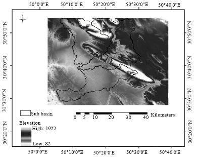 | |
| Fig. 1: | Digital Elevation Model (DEM) of the study area and 3 main sub-basins of Maroon river. Khayiz anticline has located in the middle of image, that Maroon river crosses it |
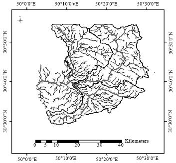 | |
| Fig. 2: | Three main sub-basins of Maroon river and their drainage network extracted from DEM using D8 algorithm |
Previous study has shown that morphometrics basin analysis can help for investigating surface dynamics and neotectonics (Day, 1979; Cox, 1994; Filosofov, 1960; Garrote et al., 2008; Golts and Rosenthal, 1992, 1993; Grohmann, 2004; Perez-Pena et al., 2009; Shahzad et al., 2009). Two data sets are used for the current work: DEM and an automatically extracted drainage network (Fig. 2). Both datasets were used to further implement the above stated morphometrics indices in the framework of some MATLAB algorithm (Shahzad and Gloaguen, 2011).
The Shuttle Radar Topography Mission (SRTM) obtained elevation data on a near-global scale to generate the most complete high-resolution digital topographic database of Earth. A SRTM DEM with 90 m spatial resolution was used in this study.
Isobase map: A drainage network consists of the relative position of stream segments which can be organized according to Strahler stream order (Strahler, 1957). Variations in stream Strahler orders have a strong connection to topography. Streams with the same Strahler orders are related to similar geological events and hence are of similar age. The spatial distribution of stream height, total length and inclination is a useful proxy for investigating underlying geological units (Golts and Rosenthal, 1992). The dynamics of stream Strahler orders and topographic variations can be studied using an Isobase map (Garrote et al., 2008; Golts and Rosenthal, 1993; Grohmann, 2004; Grohmann et al., 2007). Isobase lines represent erosional surfaces which have formed due to recent tectonic and erosional events (Filosofov, 1960). Studies suggested that Isobase maps are prepared by interpolating the elevation at the location of 2nd and 3rd order streams (Golts and Rosenthal, 1992, 1993; Grohmann, 2004). Sharp changes in the isobase map indicate the possible location of faults and/or lithological contrasts.
Incision map: The Incision map shows relative or local relief and is a tool for quantifying relative elevation. It is calculated by measuring the difference between the maximum and minimum elevation in a moving window. The calculation of relative relief is influenced by the shape and size of the moving window and is a well documented problem (Ascione et al., 2008; Klinkenberg, 1992; Guzzetti and Reichenbach, 1994). The moving window should be large enough to include at least two major ridges and/or valleys otherwise the results will not represent local relief but simply the slope gradient (Evans, 1972; Shahzad and Gloaguen, 2011).
Stream Length-gradient index (SL): Development of topography results from an adjustment between processes of erosion as streams and rivers flow over rocks and soils of variable strength (Hack, 1973). The adjustment eventually reaches a dynamic equilibrium.
The Stream Length-gradient index (SL) was defined by Hack (1973) in a study of the role of rock resistance in streams of the Appalachian Mountains of the southeastern United States. The SL index is defined as:
| (1) |
where, Δh/Δl is the local slope of the channel segment being evaluated and L is the channel length from the divide to the midpoint of the channel reach for which the index is calculated. The SL index can be used to evaluate relative tectonic activity. The SL index will increase in value as rivers and streams flow over active uplifts and may have lesser values when flowing parallel to features such as valleys produced by strike-slip faulting (Keller and Pinter, 2002). Ademeso (2009) mentioned lithological effects in such indices.
Stream power law: The lithological or structural contrasts force the streams to reach a new equilibrium condition. Mathematically, this is written in below equation:
| (2) |
that U and E are uplift and erosion rates, respectively. K is erosion efficiency factor which is related to sediments and rock strength directly, A is upstream drainage area and S is channel slope. The constants m and n are dependent on basin hydrology, hydraulic geometry and erosion process. dz/dt is the rate of changing elevation within specific time. So, if landscape is in steady-state condition, then it is equal to 0. Thus for steady state equilibrium, Eq. 1 can be written as:
| (3) |
where, m/n is the concavity of the profile and coefficient is steepness of the profile. So, it can be written as:
| (4) |
that θ and KS are concavity and steepness indices, respectively. They can be calculated directly using regression analysis of data as shown in Eq. 3, i.e., area and slope (Howard, 1994; Montgomery et al., 1996; Snyder et al., 2000; Homke et al., 2004; Whipple, 2004; Wobus et al., 2006; Shahzad et al., 2009). By combining Eq. 2 and 3, a useful relationship for calculating uplift rates is presented below:
| (5) |
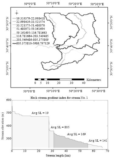
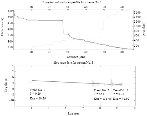
that ksn is normalized steepness index. This equation gives uplift rate for the area with steady state landscape by choosing appropriate values of m, n and K. After logarithmic regression, analysis of area and slope values, concavity and steepness values were calculated and by using their values in Eq. 4, uplift rate is calculated. Constant values of n and K is obtained from previous studies (Anderson et al., 1994; Seidl and Dietrich, 1992; Tucker and Slingerland, 1996; Wobus et al., 2006). Because of importance of knickpoint selection in understanding landscape responses to tectonics, these points were selected in stream longitudinal profile based on change in slope and concavity. Points can be viewed in Fig. 6 for Maroon river, that located in intersection of river and Khayiz anticline.
Basin hypsometry: Basin hypsometry a suitable parameter for identifying the stage of landscape development (Perez-Pena et al., 2009; Strahler, 1952). It represents the relative amount of watershed area below or above a given height. In this study all basins are automatically processed to calculate Basin hypsometry. For each basin the elevation values are classified into bins and the bins (h) are divided by the maximum elevation (H) of the basin (Shahzad and Gloaguen, 2011). All pixels (a) of the basin above the given heights in bins (h) are calculated. The total area (A) of the basin can be calculated by simply calculating the number of pixels forming the basin. A hypsometric curve is obtained by plotting (h/H) vs. (a/A). Different drainage basins can be compared by characterizing their relief as a surface-elevation curve (Garrote et al., 2008; Perez-Pena et al., 2009; Strahler, 1952). Hypsometric Integral (HI) and hypsometric curve were used in classical conceptual geomorphic models of landscape evolution as follows: for HI above 0.6 the area is in youthful stage, for HI in the range 0.35-0.6 the area is in the equilibrium(mature) phase and HI below 0.35 characterizes a monadnock phase in landscape development (Strahler, 1952). The styles of landscape evolution depend critically on the time scales of the tectonic processes in relation to the response time of the landscape. Classical conceptual models may be valid under specific tectonic conditions (Kooi and Beaumont, 1996; Miliaresis, 2001). HI can be used as an indicator of the relative amount of land from the base of the mountain to its top that was removed by erosion (aeration). Statistical moments of different hypsometric curves can be used for further analysis (Luo, 1998; Perez-Pena et al., 2009). These moments were calculated by using the MATLAB built-in methods of mean, standard deviation, skewness and kurtosis. This is especially suitable for intersecting and overlapping hypsometric curves (Shahzad and Gloaguen, 2011).
RESULTS AND DISCUSSION
The generation of morphotectonic maps for surface dynamics and basin analysis is an important tool for tectono geomorphological analysis (Grohmann, 2005). These types of analyses are especially suitable in regions with drainage network anomalies and relief pattern discontinuities (Gloaguen et al., 2007, 2008; Kurz et al., 2007).
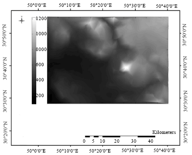 | |
| Fig. 3: | Isobase map of the study area |
The analysis of surface dynamics parameters such as Isobase, Incision and vertical dissection maps provides insight into the tectonic geomorphology of the study area. These parameters might reveal major tectonic features. The Isobase map of the study area (Fig. 3) which shows the location of 2nd and 3rd order streams is changeable. Changes in the relative position of 2nd and 3rd order streams at high or low relief correlates with some of the tectonic features, e.g. Main Mantle Thrust, Main Boundary Thrust and a linear feature as shown in Fig. 3. Other minor changes in the Isobase map might be related to residual morphotecronic features. It is in support with Grohmann et al. (2007) results.
The incision map or local relief is used to identify regions of high gradients (Guzzetti and Reichenbach, 1994). The incision map of the study area was also prepared using a moving window of 1 km2 and again shows steep changes to the west of the Khayiz. This map also shows a series of sharp changes in the NW side of the study area which is related to the EW-trending series of lineaments. Using the incision map these lineaments can be further traced to prepare a more detailed neotectonics map of the study area (Fig. 4). Moghaddam and Saghafi (2008) studied Gully erosion that is related to incision in this study and support these results.
Values of the SL index over the study area, determined from digital elevation models and Geographic Information System (GIS), are shown on Fig. 5. In order to discriminate values at the index related to rock resistance, different levels of average rock strength were defined (by rock type and field observation) from very low strength (silt, sand, marl and peat), low strength (older alluvial fan deposits and fairly well-consolidated conglomerate), moderate strength (fillite and schist), high strength (calcareous sandstone, travertine and conglomerate) and very high strength (low grade metamorphisms producing rocks such as marble). Based upon the quantitative SL indices linked to relative rock resistance described above with field observations suggest that:
| • | Along the southern part of the Khayiz, values of the SL index show a variable distribution. The highest and perhaps most anomalous values of the index are along the Maroon River on its pass from Khayiz anticline. These high indices are not associated with particularly resistant rocks and so these anomalies are interpreted in the SL index to be a tectonic signal. Several locations along the western flank of the Khayiz anticline also have anomalously high SL index values on relatively soft rocks |
| • | Along the NE portion of the study area, SL indices tend to be relatively low compared with the other parts. Anomalous values of the indices along the streams 2 and 3 are related to outcrops of the resistant massive limestone found along the river profile. Maghfouri-Moghadam et al. (2009) studied Tarbur formation that supports these results |
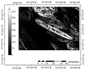 | |
| Fig. 4: | Incision map of the study area |
 | |
| Fig. 5: | Hack index (SL) map and profile of Maroon river |
 | |
| Fig. 6: | Longitudinal profile of the Maroon river |
In this study, Maroon river is analyzed using stream power law. The analysis is discussed here in detail. The stream profile analysis of the Maroon river is shown in Fig. 6. This is a three segment stream. Two knickpoints shows tectonic activity. All knickpoints show the presence of local faults. Three trends observed in this stream based on morphologic conditions, i.e., an upper segment, middle segment and lower segment. The upper segment passed on relict landscape with steepness index 20.89 and uniform concavity index 0.29 which means that it suffer less erosion. The middle segment shows intermediate concavity 554 and steepness 138.05 which means that erosion process are active. The lower segment suggests lower concavity and steepness indices, i.e., 0.38 and 41.92. As the stream go down, the sharp change in the geomorphic indices shows gradual changes in lithology and tectonic activity. The northern part of the region has low steepness values and because steepness is directly related to uplift rate it means that region undergone less deformation processes on northern section, compared to other parts.
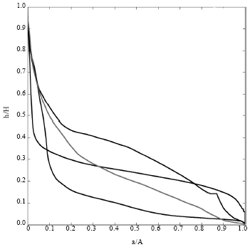 | |
| Fig. 7: | Hypsometric curves of four main streams of study area. Curves have been calculated using a 90 m DEM. Gray curve is Maroon river’s and black ones are surrounding basins |
Khavari et al. (2009) study neotectonics of central Alborz, Iran but use another approach in their study. In this study, uplift rate is computed using steepness and concavity but is Khavari et al. (2009) this is not quantified.
Hypsometry analysis is based on investigating the shape of basin hypsometric curves which vary from concave to convex. Here, 4 basins of Strahler order 5 were studied in the Khayiz region. A combined hypsometric plot of all the basins is shown in Fig. 7. Grey curve is Maroon river’s curve. This shape type is usually attributed to mature basins while the basins on the southern side reveal a concave shape that suggests old stage. This means that the basins on the northern side are young and can be related to the development of the Khayiz landscape. The analysis suggests that the drainage evolution in this area is sensitive to recent tectonics, thus reinforcing some ideas on the neotectonics of Khayiz and surrounding regions. This is confirmed by Perez-Pena et al. (2009) methodology and results.
CONCLUSION
Within the study of surface dynamics and tectonics geomorphology of Khayiz region, several morphometric methods were applied in a GIS environment and proposed methodology is presented. The integration between GIS and statistics in morphometric analysis allows agility and precision in determination of necessary parameters. The methods presented in this work can be adapted according to necessities and available tools; documentation of input and output file formats in the source code makes easy to implement custom-written software. Use of free and open-source tools guarantees access to everyone and its increasing popularization opens new development perspectives in this research field.
The morphometric methods described in this paper and implemented in the MATLAB software applying tectonic geomorphologic analyses to global DEMs. Further analysis of exported parameters and morphometric maps can be carried out by any individual within or outside MATLAB.
Surface roughness and basin analysis and the generation of morphometric maps shed new light on the tectonics of the Khayiz Region, Zagros Mountains, Iran. Observations showed that the morphometric maps strongly correlate with previously identified features and that our detailed analysis has brought hitherto unrecognized features into focus.
REFERENCES
- Codilean, A.T., P. Bishop and T.B. Hoey, 2006. Surface process models and the links between tectonics and topography. Prog. Phys. Geogr., 30: 307-333.
CrossRefDirect Link - Ascione, A., A. Cinque, E. Miccadei, F. Villani and C. Berti, 2008. The Plio-Quaternary uplift of the Apennine chain: New data from the analysis of topography and river valleys in Central Italy. Geomorphology, 102: 105-118.
CrossRefDirect Link - Berberian, M., 1995. Master blind thrust faults hidden under the Zagoros folds: Active basement tectonics and surface morphotectonics. Tectonophysics, 241: 193-224.
CrossRefDirect Link - Berberian, M. and G.C.P. King, 1981. Towards a paleogeography and tectonic evolution of Iran. Can. J. Earth Sci., 18: 210-265.
CrossRefDirect Link - Cox, R.T., 1994. Analysis of drainage-basin symmetry as a rapid technique to identify areas of possible quaternary tilt-block tectonics: An example from the Mississippi Embayment. Geol. Soc. Am. Bull., 106: 571-581.
CrossRefDirect Link - Day, M.J., 1979. Surface roughness as a discriminator of tropical karst styles. Zeitschrift fuer Geomorphologie, 32: 1-8.
Direct Link - Garrote, J., G.G. Heydt and R.T. Cox, 2008. Multi-stream order analyses in basin asymmetry: A tool to discriminate the influence of neotectonics in fluvial landscape development (Madrid Basin, Central Spain). Geomorphology, 102: 130-144.
CrossRefDirect Link - Gloaguen, R., A. Kaessner, F. Wobbe, F. Shahzad and S.A. Mahmood, 2008. Remote sensing analysis of crustal deformation using river networks. Proceedings of the IEEE International Geosciences and Remote Sensing Symposium, July 7-11, 2008, Boston, MA., USA., pp: IV-1-IV-4.
CrossRefDirect Link - Gloaguen, R., P.R. Marpu and I. Niemeyer, 2007. Automatic extraction of faults and fractal analysis from remote sensing data. Nonlinear Processes Geophys., 14: 131-138.
CrossRefDirect Link - Golts, S. and E. Rosenthal, 1993. A morphotectonic map of the Northern Arava in Israel, derived from isobase lines. Geomorphology, 7: 305-315.
CrossRefDirect Link - Golts, S. and E. Rosenthal, 1992. Morphotectonic methods to infer groundwater flow under conditions of scarce hydrogeological data: The case of Northern Arva, Israel. Applied Hydrogeol., 3: 5-19.
CrossRefDirect Link - Grohmann, C.H., 2004. Morphometric analysis in geographic information systems: applications of free software GRASS and R. Comput. Geosci., 30: 1055-1067.
CrossRefDirect Link - Grohmann, C.H., 2005. Trend-surface analysis of morphometric parameters: A case study in Southeastern Brazil. Comput. Geosci., 31: 1007-1014.
CrossRefDirect Link - Grohmann, C.H., C. Riccomini and F.M. Alves, 2007. SRTM-based morphotectonic analysis of the Pocos de Caldas Alkaline Massif, Southeastern Brazil. Comput. Geosci., 33: 10-19.
CrossRefDirect Link - Guzzetti, F. and P. Reichenbach, 1994. Towards a definition of topographic divisions for Italy. Geomorphology, 11: 57-74.
CrossRef - Homke, S., J. Verges, H. Emami, M. Garces and R. Karpuz, 2004. Magnetostratigraphy of Miocene-Pliocene Zagros foreland deposits in the front of the Push-e Kush Arc (Lurestan Province, Iran). Earth Planetary Sci. Lett., 225: 397-410.
CrossRefDirect Link - Klinkenberg, B., 1992. Fractals and morphometric measures: Is there a relationship? Geomorphology, 5: 5-20.
CrossRefDirect Link - Kooi, H. and C. Beaumont, 1996. Large-scale geomorphology: Classical concepts reconciled and integrated with contemporary ideas via a surface process models. J. Geophys. Res., 101: 3361-3386.
CrossRefDirect Link - Kurz, T., R. Gloaguen, C. Ebinger, M. Casey and B. Abebe, 2007. Deformation distribution and type in the Main Ethiopian Rift (MER): A remote sensing study. J. Afr. Earth Sci., 48: 100-114.
CrossRefDirect Link - Luo, W., 1998. Hypsometric analysis with a geographic information system. Comput. Geosci., 24: 815-821.
CrossRefDirect Link - Sepehr, M. and J.W. Cosgrove, 2005. Role of the Kazerun fault in the formation and deformation of the Zagros Fold-Thrust Belt, Iran. Tectonics, 24: 1-13.
CrossRefDirect Link - Shahzad, F., S.A. Mahmood and R. Gloaguen, 2009. Drainage network and lineament analysis: An approach for Potwar Plateau (Northern Pakistan). J. Mountain Sci., 6: 14-24.
Direct Link - Strahler, A.N., 1952. Hypsometric (area-altitude) analysis of erosional topography. Geol. Soc. Am. Bull., 63: 1117-1142.
CrossRefDirect Link - Montgomery, D.R., T.B. Abbe, J.M. Buffington, N.P. Peterson, K.M. Schmidt and J.D. Stock, 1996. Distribution of bedrock and alluvial channels in forested mountain drainage basins. Nature, 381: 587-589.
CrossRef - Snyder, N.P., K.X. Whipple, G.E. Tucker and D.J. Merritts, 2000. Landscape response to tectonic forcing: Digital elevation model analysis of stream profiles in the Mendocino triple junction region, northern California. Bull. Geol. Soc. Am., 112: 1250-1263.
CrossRefDirect Link - Wobus, C., K.X. Whipple, E. Kirby, N. Snyder and J. Johnson et al., 2006. Tectonics from Topography: Procedures, Promise and Pitfalls. In: Tectonics, Climate and Landscape Evolution: GSA Special Paper 398, Willett, S.D., N. Hovius, M.T. Brandon and D.M. Fisher (Eds.). Geological Society of America, Boulder, CO., pp: 55-74.
- Whipple, K.X., 2004. Bedrock rivers and the geomorphology of active orogens. Annu. Rev. Earth Planetary Sci., 32: 151-185.
CrossRef - Howard, A.D., 1994. A detachment-limited model of drainage basin evolution. Water Resour. Res., 30: 2261-2285.
CrossRef - Tucker, G.E. and R. Slingerland, 1996. Predicting sediment flux from fold and thrust belts. Basin Res., 8: 329-349.
CrossRef - Ademeso, O.A., 2009. Deformation traits in the charnockitic rocks of akure area, Southwestern Nigeria. Asian J. Earth Sci., 2: 113-120.
CrossRefDirect Link - Asadiyan, M.H. and A. Zamani, 2010. Could dahw/tahw dissolve problems of plate tectonics?. Asian J. Earth Sci., 3: 190-212.
CrossRefDirect Link - Bolca, M., U. Altinbas, Y. Kurucu and M.T. Esetlili, 2005. Determination of change detection of lanscape of the kucuk menderes delta using GIS and the remote sensing techniques. J. Applied Sci., 5: 659-665.
CrossRefDirect Link - Khavari, R., M. Arian and M. Ghorashi, 2009. Neotectonics of the south central alborz drainage basin, in NW Tehran, N Iran. J. Applied Sci., 9: 4115-4126.
CrossRefDirect Link - Maghfouri-Moghadam, I., R. Zarei-Sahamieh, A. Ahmadi-Khalaji and Z. Tahmasbi, 2009. Microbiostratigraphy of the tarbur formation, zagros basin, Iran. J. Applied Sci., 9: 1781-1785.
CrossRefDirect Link - Moghaddam, M.H.R. and M. Saghafi, 2008. Gully erosion monitoring on shakhen drainage basin, southern khorasan province, Iran. J. Applied Sci., 8: 946-955.
CrossRefDirect Link - Safaei, H., A. Taheri and H. Vaziri-Moghaddam, 2008. Structural analysis and evolution of the kashan (Qom-Zefreh) ftaul, Central Iran. J. Applied Sci., 8: 1426-1434.
CrossRefDirect Link - Soleimani, B., K. Nazari, H.A. Bakhtiar, G. Haghparast and G. Zandkarimi, 2008. Three-dimensional geostatistical modeling of oil reservoirs: A case study from the ramin oil field in Iran. J. Applied Sci., 8: 4523-4532.
CrossRefDirect Link - Nejad, H.T., 2009. Geoelectric investigation of the aquifer characteristics and groundwater potential in Behbahan Azad University Farm, Khuzestan Province, Iran. J. Applied Sci., 9: 3691-3698.
CrossRefDirect Link