
M. Gholipoor
Department of Agronomy and Plant Breeding, Shahrood University of Technology, P.O. Box 36155-316, Shahrood, Iran
Asian Journal of Agricultural Research
Year: 2008 | Volume: 2 | Issue: 2 | Page No.: 45-55


ABSTRACT
In this study, soil water balance sub-model of CYRUS with some modifications was applied for estimating the value of runoff for slopes 0 to 16% (with interval of 2%) in five locations of Iran. Results indicated that the cumulated runoff over six months is averagely 62, 52, 14, 13 and 4 mm for Shiraz, Kermanshah, Mashhad, Tabriz and Isfahan, respectively. Compared to Kermanshah, the value of runoff was higher for Shiraz in months December, January and February; while that of runoff in March, April and May was lower for Shiraz than for Kermanshah; based on value of runoff for month in which planting (plowing the soil and consequently making it more erodable) of chickpea is achieved, Shiraz appeared to be more at risk for cultivation in slopped-farms as compared to Kermanshah. For Mashhad and Tabriz that of runoff found to be sensible in March, April and May, but not in others. Averaged over slopes and locations, frequency of heavy runoffs found to be higher in January and March, compared to other months. The incrementing effect of slope on runoff in January was higher for Shiraz, as compared to Kermanshah, but in March it was lower for Shiraz than for Kermanshah; in April that of slope was more sensible for Mashhad, when compared with Shiraz. Generally, results suggest that for Shiraz and Kermanshah, very low-slopped farms should be devoted to cultivation; additionally, the cultivation of spring crops should be substituted by winter crops; for situations in which spring-crops are dominantly cultivated, the sowing of spring-crops for which dormant sowing is achievable, could be preferred. These substitutions can coincide more vegetation covered-soil with heavy runoffs and consequently decreased soil erosion.
PDF Abstract XML References Citation
How to cite this article
M. Gholipoor, 2008. Comparative Evaluating the Climate-Related Runoff Production in
Slopped-Farms of Iran, Using Simulation. Asian Journal of Agricultural Research, 2: 45-55.
DOI: 10.3923/ajar.2008.45.55
URL: https://scialert.net/abstract/?doi=ajar.2008.45.55
DOI: 10.3923/ajar.2008.45.55
URL: https://scialert.net/abstract/?doi=ajar.2008.45.55
INTRODUCTION
Iran has an area of 1,648,000 km2. It has been reported by FAO that roughly one-third of this area is arable farmland, of which little portion is under cultivation, because poor soil and lack of adequate water distribution. Less than one-third of the cultivated area is irrigated; the rest is devoted to dry farming. This country includes two major mountain ranges, named Alborz and Zagros (Fig. 1); these mountains ridges which run east and southeast from the northwest corner of the country surround two uninhabited deserts, Dasht-e Lut and Dasht-e Kavir; therefore, some area of cultivated farms is declivitous and usually devoted to dry farming.
It is generally accepted that cultivation in declivitous farms could results in (increased) runoff production and consequently (more) soil erosion. Water erosion is one of the main factors responsible for declining soil yield potential, due to losses of sediments, nutrients and organic carbon by runoff (Castro-Filho et al., 1999); additionally, it causes many environmental problems. The principal environmental issues associated with runoff are the impacts to surface water, groundwater and soil through transport of water pollutants to these systems.
 | |
| Fig. 1: | Map of Iran showing main mountain ranges (more highlighted areas) and selected stations (filled squares) for this study |
Ultimately these consequences translate into human health risk, ecosystem disturbance and impact to water resources. Some of the contaminants that create the greatest impact to surface waters arising from runoff are petroleum substances, herbicides and nutrients (which causes eutrophication) (Pote et al., 1996).
Generally, the value of runoff is expected to be not the same for different locations; because numerous factors may affect runoff, including rain intensity and duration, the portion of precipitation which is as snow, the inherent infiltration capacity of the soil, antecedent moisture, surface properties and vegetation cover (Hillel and Tadmor, 1962; Blackburn, 1975; Scoging, 1989). Surface properties that affect runoff include the formation of a mineral crust (Tarchitzky et al., 1984; Zhang and Miller, 1996), mulch (Kramer and Meyer, 1969), microbiotic crust, stoniness (Poesen and Ingelmo-Sanchez, 1992; Cerda, 2001) and the surface micro relief. Antecedent moisture is also affected by many factors, including atmospheric demand for water vapor [Vapor Pressure Deficit (VPD), i.e., the difference between the actual water vapor pressure and the saturation of water vapor pressure at a particular temperature]. Unlike relative humidity, vapor pressure deficit has a simple nearly straight-line relationship to the rate of evapotranspiration.
For decreasing the cultivation-resulted soil erosion in slopped-farms, the climate-related capability of each location for runoff production should be identified. It was found no published report regarding named capability in Iran; therefore this simulation study was aimed to compare five locations in Iran for a generally estimated value of runoff, for monthly value of runoff, for value of runoff for month in which planting (plowing the soil and consequently making it more erodable) and early establishment of chickpea are achieved, for frequency of heavy runoffs and for increasing effect of slope on runoff. The result of this study can be used for decreasing cultivation-resulted erosion in slopped-farms, through selecting more appropriate slope and/or planting date for cultivation.
MATERIALS AND METHODS
Five locations with long-term and reliable daily weather data were selected for the study to represent a large geographical area and several climatic zones in Iran (Fig. 1). The selected sites included Isfahan (32.67 °N, 51.87 °E and 1600 m asl), Shiraz (29.55 °N, 52.60 °E and 1488 m asl), Kermanshah (34.32 °N, 47.12 °E and 1322 m asl), Tabriz (38.13 °N, 46.28 °E and 1364 m asl) and Mashhad (36.27 °N, 59.63 °E and 990 m asl) (Fig. 1). Mean annual temperature is 16.4 °C for Isfahan, 17.8 °C for Shiraz, 14.4 °C for Kermanshah, 12.6 °C for Tabriz and 14.3 °C for Mashhad. The annual rainfall occurs during 35 wet days for Isfahan, 42 for Shiraz, 74 for Kermanshah, 81 for Tabriz and 63 for Mashhad. For each location, 39 (1966-2004 for Tabriz) to 44 years (1961-2004) of daily data for rainfall and maximum and minimum temperatures and sunshine hours were available. Solar radiation data were calculated from sunshine hours and extraterrestrial solar radiation as outlined by Doorenbos and Pruitt (1977).
The model CYRUS was used for investigating the climate-related runoff production in above named locations; firstly, it was recorded in Qbasic programming language and run for medium deep silty loam soil, using above named weather data. The CYRUS was initially designed in 1999 by Soltani et al. (1999). Then it was developed for different components (Soltani et al., 2000, 2004a, 2005, 2006a, b, c and d). This model has been used for some simulation studies/investigations (Gholipoor and Soltani, 2005a, b; 2006a, b; Gholipoor et al., 2006a, b; Gholipoor, 2007).
Briefly, in seedling emergence sub model of CYRUS, emergence response to temperature is described by a dent-like function with cardinal temperatures of 4.5 (base), 20.2 (lower optimum), 29.3 (upper optimum) and 40 °C (ceiling temperature). Six physiological days (i.e., number of days under optimum temperature conditions; equivalent to thermal time of 94 °C days) are required from sowing to emergence at a sowing depth of 5 cm. The physiological days requirement is increased by 0.9 days for each centimeter increase in sowing depth. Snow cover effect is considered on the basis of daily maximum and minimum temperatures, as presented in Ritchie (1991).
In leaf sub model, cardinal temperatures for node appearance are 6.0 °C for base, 22.2 °C for optimum and 31.0 °C for ceiling temperature. Leaf senescence on the main stem starts when the main stem has about 12 nodes and proceeds at a rate of 1.67% per each day increase in physiological day (a day with non-limiting temperature and photoperiod). Leaf production per plant versus main stem node number occurs in two phases; phase 1 when plant leaf number increases with a slower and density-independent rate (three leaves per node) and phase 2 with a higher and density-dependent rate of leaf production (8-15 leaves per node).
Phenological development is calculated using multiplicative model that include a dent-like function for response to temperature and a quadratic function for response to photoperiod. Photoperiod-sensitivity is considered to be different in various cultivars and cardinal temperatures for phenological development are 0 °C for base, 21 °C for lower optimum, 32 °C for upper optimum and 40 °C for ceiling temperature. The cultivars require 25-31 physiological days from emergence to flowering, 8-12 from flowering to pod initiation, 3-5 from pod initiation to pod filling, 17-18 from pod filling to pod yellowing and 6 from pod yellowing to physiological maturity.
The biomass production is calculated based on extinction coefficient (KS) and Radiation Use Efficiency (RUE). It assumes that KS is not radiation- and plant density-dependent. The RUE assumes to be constant (1 g MJ-1) across plant densities, but not across temperatures. After correction of RUE for temperature, it is not affected by either solar radiation or Vapor Pressure Deficit (VPD). The partitioning of biomass between leaves and stems is achieved in a biphasic pattern before first-seed stage. After this stage, the fixed partitioning coefficients are used for calculating biomass allocation.
Despite of many simulation models in which the linearity of harvest index increases has been used as a simple means to analyze and predict crop yield in experimental and simulation studies (Soltani et al., 2005), the CYRUS model assumes that its increase is biphasic with turning point temperature equal to 17 °C. The similar approach has been proved to be appropriate for application in wheat (Soltani et al., 2004b).
The relation between total N and total biomass throughout the growth period is based on non-linear segmented model (with two segments/phases). Therefore, the rates of N accumulation during phase 1 and 2 are different and the turning point between two phases of N accumulation is considered 218.3 g biomass m-2. The distribution of N to different parts of plant is calculated using appropriate functions and coefficients.
In soil water balance sub-model, daily soil water content is estimated as fraction transpirable soil water [FTSW, which ranges from 0 (point at which plants face with wilting) to 1 (field capacity)]. Similar to that described by Amir and Sinclair (1991), it accounted for additions from infiltration and losses from soil evaporation, transpiration and drainage. Infiltration is calculated from daily rainfall less any runoff. Runoff is estimated using the curve number technique (Knisel, 1980). Soil evaporation (E) is calculated using the two-stage model as implemented in spring wheat model developed by Amir and Sinclair (1991). Stage 1 E occurs when water present in the top 200 mm of soil and FTSW for the total profile is greater than 0.5. Stage 2 E occurs when the water in the top layer is exhausted or the FTSW for the total soil profile reaches to less than 0.5. In stage 2, E is decreased substantially as a function of the square root of time since the start of stage 2. The calculation of E is returned to stage 1 only when rain or irrigation of greater than 10 mm occurs. Like procedure of Tanner and Sinclair (1983) and Sinclair (1994), the daily transpiration rate is calculated directly from the daily rate of biomass production, transpiration efficiency coefficient (= 5 Pa) and VPD. The calculation of VPD is based on suggestion of Tanner and Sinclair (1983) that it to be approximately 0.75 of the difference between saturated vapor pressure calculated from daily maximum and minimum temperatures.
In this investigation, as mentioned previously, the sub-models regarding growth and development of chickpea were inactivated and only soil water balance sub-model was used; therefore, some modifications were made as follows: (1) transpiration was assumed equal to zero; this was based on this fact that during follow (non-planting period), it is tried to remove any weed/plant (as a cause of soil water loss through transpiration) from the soil by specialized-tillage and/or other techniques for preserving the water in soil for crop use, (2) in original model, time course for calculations is growing period of chickpea; but, here it was considered for entire year and (3) a sub-model was added for calculating snow cover and snow melting as report of Ritchie (1991); this procedure has been used by many researchers including Soltani et al. (2006d), in this sub-model the value of snow is calculated based on maximum temperature; this temperature is also used for daily calculating amount of snow melting.
The calculated attributes were monthly value of runoff for slopes 0 to 16% (with interval of 2%) and frequency of runoff grater than zero and lower than and/or equal to 1 mm (0 < R ≤ 1), of 1 < R ≤ 2, of 2 < R ≤ 3, of 3 < R ≤ 4, of 4 < R ≤ 5, of 5 < R ≤ 6, of 6 < R ≤ 7 and of 7 < R ≤ 8. Some additional attributes were also calculated for interpreting capability of locations for producing runoff, which were as follows: (1) predicted time of early establishment and canopy closure for chickpea (Gholipoor and Soltani, 2006c), using the all sub-models of CYRUS for density of 40 stand m-2, (2) planting date of chickpea (as the 7 days with no rainfall and with mean temperature above the base temperature), (3) number of wet days (days with P > 0 mm), frequency of 0 < P ≤ 5, of 5 < P ≤ 10, of 10 < P ≤ 15, of 15 < P ≤ 20, of 20 < P ≤ 25, of 25 < P ≤ 30 and of P > 30, (4) the portion of snow to precipitation, (5) cumulative probability of occurring for days with maximum temperature lower than and/or equal to 1 °C, (6) the value of evaporation, (7) that of FTSW at depth 0-20 (FTSW20) and (8) that of FTSW at depth 0-60 cm (FTSW60).
RESULTS AND DISCUSSION
In this study, only results regarding months December, January, February, March, April and May were presented; because for other months, the value of rainfall and consequently that of runoff were lower, as compared to averaged values of these attributes over above named months and/or were equal to zero. The average values of monthly rainfall for 6 months were presented in Table 1.
| Table 1: | Monthly rainfall (and percent of annual rainfall) in 6 months for five locations of Iran |
 | |
| #: The portion of six-month cumulated-rainfall to annual rainfall may be negligibly lower and/or higher than percent in parenthesis; because the round (non-decimal) values were only presented | |
Six months sum rainfall was 104.0 mm (87% of annual rainfall) for Isfahan, 306.6 (92%) for Shiraz, 377.4 (81%) for Kermanshah, 200.5 (72%) for Tabriz and 223.1 (87%) for Mashhad. In December, Shiraz had higher percent of annual rainfall, compared to other locations (22%, versus, 9 to 17%); this is also true for January and February; in March, the obtained percents tended to be highest and 2nd highest for Mashhad and for Kermanshah and Isfahan, respectively; in April it ranged from 8% (Shiraz) to 18% (Tabriz and Mashhad); in May, Tabriz appeared to have highest rainfall percentage (16%), but Shiraz showed lowest value (2%). Generally, for Tabriz, higher rainfalls were nearly obtained in March, April and May, compared to other months; it was true in March and April for Mashhad, in December and January for Shiraz and in December, January, March and April for Isfahan and for Kermanshah.
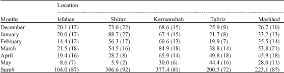
The relation of monthly runoff with slope was shown in Fig. 2. Generally, in all six months the value of runoff directly changed with changing slope. In December, the value of runoff was negligible for Isfahan (the ratio of monthly snow to precipitation was about 4%), Mashhad (12%), Tabriz (25%), but considerable for Shiraz (negligible) and Kermanshah (negligible) (Fig. 2A). While the difference between Shiraz and Kermanshah for monthly rainfall found to be little (73.0 mm versus 68.6 mm, respectively), value of runoff for Shiraz was about more than two times higher, as compared to Kermanshah; because, frequency of shallow rainfalls was lower for Shiraz than for Kermanshah, but that of heavy rainfalls [e.g., grater than 30 mm (p > 30)] was higher (0.48 versus 0.11 days per month) for Shiraz, as compared to Kermanshah. It should be pointed out that although Shiraz was warmer than Kermanshah (averagely, 6.10 versus 1.83 °C), the probability of occurrence of maximum temperatures equal to and/or lower than 1 °C (Tmax ≤ 1 °C) [the temperatures for which the precipitation falls as snow (Richie, 1991)] was nearly the same for them (about < 1 and 2% for Shiraz and Kermanshah, respectively); despite of these probabilities which were relatively sensible, snow falling, as mentioned, found to be negligible, due to very little coincidence of fallings with Tmax ≤ 1 °C, especially for Kermanshah. The lines which represent values of runoff for slopes in Shiraz and Kermanshah were nearly parallel, indicating no difference between these locations for increasing effect of slope on runoff.
In January, the value of runoff appeared to be nearly zero (the ratio of monthly snow to precipitation was about 81%) for Tabriz, little for Mashhad (8%) and Isfahan (11%), but considerable for Shiraz (1%) and Kermanshah (2%) (Fig. 2B). For Kermanshah, although the value of rainfall was nearly the same in January and December, that of runoff was relatively more considerable in January than in December; this is due to higher frequency of heavy rainfalls in January, as compared to December (P > 30: 0.18 versus 0.10 days per month, respectively); this matter is further confirmed by this fact that precipitations as snow falling were sensible in January, but negligible in December. For Shiraz, either higher rainfall or enhanced frequency of heavy rainfalls in January as compared to December caused the value of runoff to be very higher in January, when compared with that of runoff in December. The increasing effect of slope on runoff found to be higher for Shiraz than for Kermanshah.
 | |
| Fig. 2: | Relation of monthly runoff with slope in six months of year for five locations of Iran |
In February, the positive effect of incrementing slope on runoff was nearly the same for all locations (Fig. 2C). The value of runoff found to be little for Mashhad, Isfahan and Tabriz, but considerable for Shiraz and Kermanshah. Shiraz (with 56.3 mm rainfall) tended to have higher runoff, compared to Kermanshah (60.6 mm); this was due to the fact that snow falling was negligible for Shiraz, but sensible (4%) for Kermanshah; additionally, the frequency of heavy rainfalls was higher for Shiraz, when compared with Kermanshah (about twice for P > 30 and five times for 25 ≤ P < 30).
Averaged over slopes, value of runoff found to be 1.09 mm for Isfahan, 6.50 mm for Shiraz, 13.32 mm for Kermanshah, 4.36 mm for Mashhad and 3.61 mm for Tabriz in March (Fig. 2D). Evaporation is one of the important factors that can affect soil water content and consequently runoff production. Although the value (intensity) of factors which influence evaporation, including solar radiation and temperature (Amir and Sinclair, 1991), was more considerable for Shiraz than for Mashhad (radiation: 17.78 versus 14.62 MJ m-2 day-1, respectively; temperature: 11.69 versus 8.32 °C, respectively), they tended to have nearly the same value of evaporation; this may be due to more frequent shallow rainfalls for Mashhad than for Shiraz (0 < P ≤ 5: 8.30 versus 4.36 days per month, respectively; 5 < P ≤ 10: 2.11 versus 0.84 days per month, respectively) and hence, higher availability of water in upper layers of the soil for evaporation in Mashhad, as compared to Shiraz (averaged FTSW20: 0.62 versus 0.36, respectively; averaged FTSW60: 0.83 versus 0.68, respectively); these factors and others, like frequency of heavy rainfalls, caused that Shiraz and Mashhad with the same value of rainfall show nearly different capability for runoff production. In this month, the increasing effect of slope on value of runoff was higher for Kermanshah than for Shiraz.
In April, the highest value of runoff was found for Kermanshah, but lowest for Isfahan (Fig. 2E). Tabriz, Mashhad and Shiraz tended to have the same value of runoff for slope zero, but different for other slopes, indicating the interaction between location and slope for runoff. This interaction was also sensible for Kermanshah and Mashhad in May (Fig. 2F); in slopes higher than 4%, the value of runoff found to be higher for Mashhad than for Kermanshah, but in slopes 0-4%, it was the same for these locations. That of runoff tended to be highest for Tabriz, but zero for Isfahan and Shiraz. Averaged over slopes and then over locations, the value of runoff for this month was lower than that for above mentioned months.
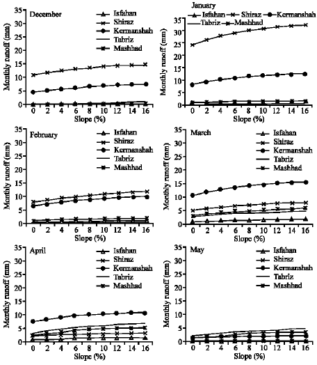
Monthly frequency for different values of runoff, i.e., for runoff grater than zero and lower than and/or equal to 1 mm (0 < R ≤ 1), for 1 < R ≤ 2, for 2 < R ≤ 3, for 3 < R ≤ 4, for 4 < R ≤ 5, for 5 < R ≤ 6, for 6 < R ≤ 7 and for 7 < R ≤ 8 was given in Fig. 3. It should be pointed out that each frequency was obtained from averaging the frequencies over slopes 0 to 16%.
In December, when frequencies were averaged over these values of runoff, it was appeared that the highest and 2nd highest frequency of runoff are for Kermanshah and Shiraz, respectively; they differed for frequencies of R ≤ 3, but nearly not for those of R > 3. The difference between other locations for frequency of 0 < R ≤ 1 was nearly sensible; those of R > 1 tended to be zero. In January, Shiraz and Kermanshah appeared to have the same frequencies of 6 < R ≤ 8, but different frequencies of R ≤ 6; in comparison with Shiraz, Kermanshah had higher frequencies of 0 < R ≤ 2, while those of 2 < R ≤ 6 were lower for Kermanshah than for Shiraz. For Isfahan and Tabriz, frequency of 0 < R ≤ 1 found to be sensible, but those of R > 1 were zero. For Mashhad, the calculated frequencies tended to be sensible for 0 < R ≤ 4. In February, order of locations for magnitude of frequency of 0 < R ≤ 1 was as Kermanshah > Shiraz > Mashhad > Tabriz > Isfahan. Frequencies of 3 < R ≤ 7 found to be sensible for Kermanshah, but negligible for other locations. In March, order of locations for that of 0 < R ≤ 1 was not identical to what obtained in February; it was as Kermanshah > Mashhad > Tabriz > Shiraz > Isfahan. Frequency of 1 < R ≤ 2 tended to be lowest for Isfahan, but highest for Kermanshah, Mashhad and Tabriz. In April, no difference was nearly found between Mashhad and Kermanshah for frequencies of 0 < R ≤ 2. The highest frequencies of 0 < R ≤ 2 were obtained for Tabriz, but lowest for Isfahan and Shiraz. Generally, when frequencies were averaged over above named values of runoff and then over locations, it found that the frequency of runoff is lower in May than in other months. In this month, frequencies of 0 < R ≤ 7 nearly tended to be highest for Tabriz. For Kermanshah and Mashhad the obtained frequencies appeared to be sensible only for 0 < R ≤ 2.
In regions with winter-dominant rainfalls, like Iran, for non-facing and/or less-facing the rainfed-spring-crops with terminal drought, the planting (plowing the soil) should be achieved immediately after rising the temperature above the base temperature (for germination) and additionally, when the soil is not wet; it is obvious that in such regions, the plowed-soil in declivitous farms is more susceptible to runoff-resulted erosion, due to its disturbance. For avoiding/decreasing the coincidence of planting date with heavy runoffs, aware of planting date and times with heavy runoff is required. Based on value of runoff for month in which planting and early establishment of chickpea are achieved, Shiraz appeared to be more at risk for cultivation in slopped-farms, as compared to Kermanshah; in other words, the value of runoff in March (early March is time of plowing the soil) for Shiraz is more considerable than that of runoff in April (early April is time of plowing) for Kermanshah. The difference between Tabriz and Mashhad for value of runoff at planting date of chickpea appeared to be not sensible. Despite of these locations, it seems that cultivation-resulted soil erosion may be negligible for (low-slopped-farms of) Isfahan; because little runoff which obtained for bare soil, can be controlled by establishment of named crop in March and by canopy closure [equivalent to dry matter about 70 g m-2 (Gholipoor and Soltani, 2006c)] in 17 April.
 | |
| Fig. 3: | Monthly frequency for runoff greater than zero and lower than and/or equal to 1 mm (0 < R ≤ 1), for 1 < R ≤ 2, for 2 < R ≤ 3, for 3 < R ≤ 4, for 4 < R ≤ 5, for 5 < R ≤ 6, for 6 < R ≤ 7 and for 7 < R ≤ 8 in six months of year for five locations of Iran. Each frequency was obtained from averaging frequencies over slopes 0 to 16% |
The locations were evaluated for risk of soil erosion (runoff production) based on coincidence of planting date of chickpea with heavy runoffs; similar evaluation can be clearly done for other crops by readers. Generally, it seems that in Shiraz and Kermanshah the very low-slopped farms should be devoted to cultivation, due to higher risk of soil erosion; additionally, the cultivation of spring crops should be substituted by winter crops like wheat; in this situation, plowing the soil is achieved when intensity of runoff is considerably low; more over, the vegetation-covered soil is more coincided with heavy runoffs and consequently more rain infiltrated, compared to bare soil (Scoging, 1989). For situations in which spring crops are dominantly cultivated, the sowing of crops, including chickpea (Soltani et al., 2006d), for which dormant sowing is achievable, could be also preferred; in this method, the crop is sown during late autumn or early winter after temperatures become too low for seed germination to occur until the following spring; then, it emerges as soon as temperatures permit and no time is lost in spring for seedbed preparation and sowing. Soltani et al. (2006d) found that in dormant sowing of chickpea in Maragheh, Iran, the seedlings emerge 22 days earlier than spring-sown chickpea; in a similar investigation in Kermanshah, Iran, it was found that seedlings would emerge 17 days earlier, compared with spring-sown situation (Gholipoor et al., 2006a); in other words, in such method of sowing, the coincidence of vegetation-covered soil with heavy runoffs is also increased and consequently, soil erosion decreased.
CONCLUSIONS
Results of this study revealed that there is considerable difference between months and locations for runoff, which is due to variability of many factors, including rainfall properties (like value and distribution) and temperature (can affect snow falling, snow melting, evaporation and etc.). Averaged over slopes, then cumulated for six months, the highest (62 mm) and 2nd highest (52 mm) value of runoff were found for Shiraz and Kermanshah, respectively, but lowest (4 mm) for Isfahan; it was 13 mm for Tabriz and 14 mm for Mashhad. Compared to Kermanshah, the value of runoff was higher for Shiraz in months December, January and February; while that of runoff in March, April and May was lower for Shiraz than for Kermanshah; based on value of runoff for month in which planting (plowing the soil and consequently making it more erodable) and early establishment of chickpea are achieved, Shiraz appeared to be more at risk for cultivation in slopped-farms, when compared with Kermanshah. For Mashhad and Tabriz that of runoff found to be sensible in March, April and May, but negligible in others; in April and May, it tended to be higher for Tabriz, as compared to Mashhad; while value of runoff in March appeared to be sensibly lower for Tabriz than for Mashhad. Averaged over slopes and locations, frequency of heavy runoffs tended to be higher in January and March, compared to other months. The incrementing effect of slope on runoff in January was higher for Shiraz, as compared to Kermanshah, but in March it was lower for Shiraz, when compared with Kermanshah; in April that of slope was more sensible for Mashhad than for Shiraz.
REFERENCES
- Amir, J. and T.R. Sinclair, 1991. A model of water limitation on spring wheat growth and yield. Field Crops Res., 29: 59-69.
CrossRefDirect Link - Blackburn, W.H., 1975. Factors influencing infiltration and sediment production of semiarid range lands in Nevada. Water Resour. Res., 11: 929-937.
Direct Link - Castro-Filho, C., J.C. Henklain, M.J. Vieira and R. Casao-Jr., 1999. Tillage methods and soil and water conservation in Southern Brazil. Soil Till. Res., 20: 271-283.
CrossRef - Cerda, A., 2001. Effects of rock fragment cover on soil infiltration, interrill runoff and erosion. Eur. J. Soil Sci., 52: 59-68.
CrossRef - Gholipoor, M. and A. Soltani, 2006. Quantitative evaluating effect of density and sowing date on time to canopy closure and period of exponential and linear growth of chickpea. Proceedings of 9th Iranian Crop Science Congress, August 27-29, Aboureyhan Campus-University of Tehran, Tehran, Iran (Abstract in Persian).
- Gholipoor, M., A. Soltani F.B. Shekari and S. Karimi, 2006. Quantitative evaluation of climate change during past 44 years of Kermanshah and its effect on chickpea phenology, using simulation. Proceedings of the 9th Iranian Crop Science Congress, August 27-29, 2006, Aboureyhan Campus- University of Tehran, Tehran, Iran, pp: 441.
- Gholipoor, M., 2007. Potential effects of individual versus simultaneous climate change factors on growth and water use in chickpea. Int. J. Plant Prod., 1: 189-204.
Direct Link - Hillel, D. and N. Tadmor, 1962. Water regime and vegetation in the Central Negev highlands of Israel. Ecology, 43: 33-41.
Direct Link - Poesen, J. and F. Ingelmo-Sanchez, 1992. Runoff and sediment yields from topsoils with different porosity as affected by rock fragment cover and position. Catena, 19: 451-474.
CrossRef - Pote, D.H., T.C. Daniel, A.N. Sharpley, P.A. Moore-Junior and D.R. Edwards et al., 1996. Relating extracted soil phosphorus to phosphorus losses in runoff. Soil Sci. Soc. Am. J., 60: 855-859.
Direct Link - Ritchie, J.T., 1991. Wheat Phasic Development. In: Modeling Plant, Soil, Systems, Hanks, R.J. and J.T. Ritchie, (Eds.). American Society of Agronomy, USA., ISBN-10: 0891181067, pp: 31-54.
Direct Link - Sinclair, T.R., 1994. Limits to Crop Yield. In: Physiology and Determination of Crop Yield, Boote, K.J., J.M. Bennet, T.R. Sinclair and G.N. Paulsen (Eds.). ASA, CSSA and SSSA, Madison, WI, ISBN-10: 0891181229, pp: 509-532.
Direct Link - Soltani, A., K. Ghassemi-Golezani, F.R. Khooie and M. Moghaddam, 1999. A simple model for chickpea growth and yield. Field Crops Res., 62: 213-224.
CrossRefDirect Link - Soltani, A., F.R. Khooie, K. Ghassemi-Golezani and M. Moghaddam, 2000. Thresholds for chickpea leaf expansion and transpiration response to soil water deficit. Field Crops Res., 68: 205-210.
CrossRefDirect Link - Soltani, A., B. Torabi, E. Zeinali and R. Sarparast, 2004. Response of chickpea to photoperiod as a qualitative long-day plant. Asian J. Plant Sci., 3: 705-708.
CrossRefDirect Link - Soltani, A., S. Galeshi, M.R. Attarbashi and A.H. Taheri, 2004. Comparison of two methods for estimating parameters of harvest index increase during seed growth. Field Crops Res., 89: 369-378.
CrossRefDirect Link - Soltani, A., B. Torabi and H. Zarei, 2005. Modeling crop yield using a modified harvest index-based approach: Application in chickpea. Field Crops Res., 91: 273-285.
CrossRefDirect Link - Soltani, A., G.L. Hammer, B. Torabi, M.J. Robertson and E. Zeinali, 2006. Modeling chickpea growth and development: Phenological development. Field Crops Res., 99: 1-13.
CrossRefDirect Link - Soltani, A., M.J. Robertson and A.M. Manschadi, 2006. Modeling chickpea growth and development: Nitrogen accumulation and use. Field Crops Res., 99: 24-34.
CrossRefDirect Link - Soltani, A., M.J. Robertson, Y. Mohammad-Nejad and A. Rahemi-Karizaki, 2006. Modeling chickpea growth and development: Leaf production and senescence. Field Crops Res., 99: 14-23.
CrossRefDirect Link - Soltani, A., M.J. Robertson, B. Torabi, M. Yousefi-Daz and R. Sarparast, 2006. Modelling seedling emergence in chickpea as influenced by temperature and sowing depth. Agric. For. Meteorol., 138: 156-167.
CrossRefDirect Link - Tarchitzky, J., A. Banin, J. Morin and Y. Chen, 1984. Nature, formation and effects of soil crusts formed by water drop impact. Geoderma, 33: 135-155.
CrossRef - Zhang, X.C. and W.P. Miller, 1996. Physical and chemical crusting processes affecting runoff and erosion in furrows. Soil Sci. Soc. Am. J., 60: 860-865.
Direct Link