
A.M. Gbadebo
Department of Environmental Management and Toxicology, University of Agriculture, Abeokuta, Nigeria
Asian Journal of Applied Sciences
Year: 2011 | Volume: 4 | Issue: 2 | Page No.: 176-185


ABSTRACT
This study determined the concentrations of natural radionuclidess in the crystalline bedrocks and soils of the selected abandoned quarries in Abeokuta area and their possible health impacts. The results of the radionuclide from rocks in the study area indicated varying concentration of 238U, 232Th and 40K. Among the quarries, rocks from AGI (Saje quarry) have the highest concentration of all the radionuclides (238U, 232Th and 40K) while the values are lower in the samples from Colonial quarry (Adigbe). However, 40K has the highest concentration in the rocks of the abandoned quarry sites, followed by 238U and least for 232Th. This trend is maintained in both the surface and subsurface soils with slight modification. It can therefore be inferred that the radionuclides types observed are based on the local geology of the study area and these radionuclides will serve as possible sources of radiation to the local quarry workers and the nearby residents alike.
PDF Abstract XML References Citation
Received: February 04, 2010;
Accepted: July 13, 2010;
Published: August 23, 2010
How to cite this article
A.M. Gbadebo, 2011. Natural Radionuclides Distribution in the Granitic Rocks and Soils of Abandoned Quarry Sites, Abeokuta, Southwestern Nigeria. Asian Journal of Applied Sciences, 4: 176-185.
DOI: 10.3923/ajaps.2011.176.185
URL: https://scialert.net/abstract/?doi=ajaps.2011.176.185
DOI: 10.3923/ajaps.2011.176.185
URL: https://scialert.net/abstract/?doi=ajaps.2011.176.185
INTRODUCTION
Assessment of radionuclides in soils and rocks in many parts of the world has been on the increase in the past two decades because of their hazard on the health of the populace (Mc-Aulay and Morgan, 1988; Belivermis et al., 2009; Gbadebo and Amos, 2010; Matiullah et al., 2004; Sesana et al., 2006; Tahir and Alaamer, 2008; Veiga et al., 2006). However, more research on natural radionuclide in Nigerian environment is required. This is necessary because radioactivity of the soil environment is one of the main sources of exposure to man while the decay products of 40K, 238U and 232Th series represent the main external source of radiation to the human body. According to USEPA (2007) investigations have shown that these radionuclide become part of the soil in the following ways viz:- (1) as part of earth’s original crust (i.e., primordial radionuclides); (2) produced and deposited by cosmic ray interactions (i.e., cosmogenic radionuclide and iii.) through man-made release (i.e., man-made radionuclide).
It has also been observed that the natural radiations that appears at the different horizons of the soils depend primarily on the geological formation in each region of the world (Fernandez et al., 1992; Floron and Kritidis, 1992; UNSCEAR, 2000; Matiullah et al., 2004). Similarly, Trace quantities of radioactive elements have been reported in all rock types, however concentration vary considerably based on rock types and also on the type of radioisotope. High radiation levels from 40K, 238U and 232Th have been associated with granitic and silicic igneous rocks (Brimhal and Adams, 1982; Harenyama et al., 2006) while lower levels of radiations are associated with sedimentary rocks with the exception of shale and phosphate (Tzortzis et al., 2004; Doveton and Merriam, 2004). Therefore, since soils are products of rock weathering, measurements of natural radioactivity in soils are of great interest for many researchers throughout the world and this has led to the world-wide natural survey of radionuclide (Karahan and Bayulken, 2000; Vassas et al., 2006). Besides, quarry activities on the exposed varieties of crystalline rocks for the purpose of constructions are fast method of human release of natural radionuclides and radiations into the various components of the environments. In this study therefore, measurements of natural radionuclide (40K, 238U and 232Th) was carried out in the soils of the abandoned quarry sites located in Saje and Adigbe in order to determine their presence, concentration and potential hazards while the measurement of radionuclides in the soils from the non-quarry site of Alabata was to serve as a control. Similarly, the determination of the radionuclides carried out on the bedrocks was to obtain clue about their provenance.
MATERIALS AND METHODS
Study area: The studied quarry sites comprise of Associated Granite Industry (AGI), Saje and Colonial Quarry (CQ) opposite Navy School, Adigbe (the two of which are abandoned) and the non-quary site (NQS), Alabata. The quarries and Alabata (i.e., the control site)fall within latitude 7°9'N and 7°14'N and longitude 3°26'E and 3°40'E on the map of Ogun state, southwest of Nigeria. The physiography of the area is that of undulating quarry sites terrain with the two abandoned quarry sites on the higher elevation compared with the control site. The detail topographic description of the area can be found in the study of Akanni (1992). The area where the quarries are located fall within the humid tropical region characterized with high precipitation and rainforest type of vegetation (Millers, 1965). The soil of the area is similar to what the USDA classification scheme categorized as ferralitic and belong to oxisol order (Gbadegesin, 1992). The geology of the entire Abeokuta where the abandoned quarry sites are located is a subset of the basement complex geology of south western Nigeria described by Jones and Hockey (1964). In the study area, it comprises of varieties of gneisses and older granites which in term of field occurrence, can be mapped as early phase granodiorite and quartz-diorite.
Sample collection: A total of 12 bedrock samples 8 of which were collected from the 2 abandoned quarry sites and the remaining 4 of which were collected from Alabata area (Non-quarry site) and a total of 24 soil samples collected from both surface and subsurface from the three sampling locations were used for this study. The soil samples were air dried and together with the rocks were pulverized/crushed and made to pass through a 2 mm mesh sieve. The powdered rock samples were stored in plastic containers and taken to the laboratory for radionuclide determination using High Resolution Gamma Spectrometry (HRGS) (Olomo et al., 1994; Fasasi et al., 1999). In the laboratory, the powdered rocks and the soil samples were separately transferred to one liter merinelli beakers and firmly sealed for secular equilibrium prior to gamma spectroscopy. Each of the powdered rock and soil samples remained sealed for about 4 weeks which was a sufficient time required to attain a state of secular radioactive equilibrium after their progeny (Karahan and Bayulken, 2000) which were separately analyzed for radionuclide concentrations. Both the field and laboratory aspect of this project work were carried out between June and August, 2009.
Quality assurance: The method of gamma ray spectroscopy adopted in this analysis followed those reported by Ajayi and Ajayi (1999) and Jibiri et al. (1999). However, the gamma counting equipments used consists of camberra vertical high-purity coaxial germanium crystal (HPGe) enclosed in the 100 mm thick lead shield. The detector was properly connected to a camberra Multi-Channel Analyzer (MCA) (Knoll, 1998). A well calibrated sand and water sources supplied by the International Atomic Energy Agency (IAEA), Vienna, Austria were used for energy and efficiency calibrations and corrected for the counting losses due to coincidence summing effects (Olomo et al., 1994). Accurate energy and efficiency of the gamma spectroscopy system were made to quantify radionuclides present in a sample, since the accuracy of all quantitative results depend on the attainable accuracy of the system’s calibration. The EMA MCA was calibrated to display gamma photo peaks between the energy range of 100 and 1500 KV, being the energy range covering all the gamma energies of radionuclides identified with reliable regularity.
RESULTS
The results of the data generated frpm this study indicated variations in the mean activity concentrations of the analyzed naturally occurring radionuclides (i.e., 232Th, 238U and 40K) in the surface and subsurface soil samples of the abandoned quarry sites vertically down the soil profile and also established a relationship between the radionuclide types and the mean value of the soil physicochemical parameters (Table 1, 2). The results also showed the concentration levels of the different radionuclides in the analyzed rocks from which they originate (Table 3).
The mean and standard deviations of the activity concentration for the different radionuclides from all the rocks of the various quarry sites follow the order of magnitude 40K (201.36±5.87-301.42±19.05 Bq kg-1)>238U (39.17±4.45-56.26±4.21 Bq kg-1)> 232Th (15.09±14.06-29.4±21.62 Bq kg-1). However, much lower radionuclide concentrations were obtained in the Colonial Quarry (CQ) site of Adigbe when compared with the AGI quarry at Saje and the non- quarry site at Alabata, the control site (Table 3).
| Table 1: | Mean values of physico-chemical characteristics and radionuclide concentrations in the (n) surface (0-5 cm) soils |
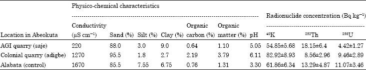 | |
| n = 12 samples | |
| Table 2: | Mean values of physico-chemical characteristics and radionuclide concentration in the (n) sub surface (25-30 cm) soil |
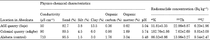 | |
| n = 12 samples | |
| Table 3: | Mean radionuclide concentrations in the (n) bedrock samples from studied abandoned quarry sites |
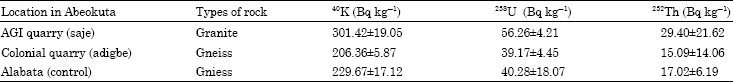 | |
| n = 12 samples | |
This low concentration value at the abandoned colonial quarry site at Adigbe may be attributed to the more than three decades (>30 years) of abandonment.
Similarly, the mean and standard deviations of the radionuclides concentrations in the surface soils of the abandoned quarry sites were relatively lower than the subsurface soils. It can also be observed that the same pattern of order of magnitude in the concentration level of radionuclides content exist for both the surface and subsurface soils, i.e., 40K>232Th> 238U, a pattern which slightly varied from what was obtainable in the crystalline bedrock samples from the study area.
Comparison of the mean radionuclide concentration levels in both surface and subsurface soil samples among different quarry sites revealed that the soil of Colonial quarry has the highest 40K radionuclide contents. 232Th level was highest in the soils around the abandoned AGI quarry site, Saje and 238U was found to be highest in the soils of the non-quarry site in Alabata (i.e., Control).
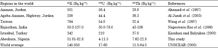
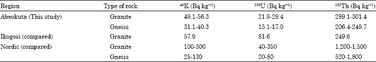
In order to infer the degree of similarity or differences, the mean concentration of different radionuclides obtained from both the surface and subsurface soils and the crystalline rocks in this study are compared with those of other workers around the world (Table 4, 5) and the results indicated that there is similarity in the types of radionuclide but a wide variety in their concentration level. The radionuclide levels in the granite rocks of the abandoned quarries are relatively less than the values obtained in the granite rocks of Ikogosi warm spring at Ijero Ekiti and far less than those of Nordic granite rocks.
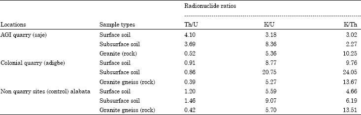
However, the radionuclide contents of the gneissic rocks analyzed in this study are relatively close to the values obtained in the gneissic rocks of the Nordic region with the exception of 40K. This trend is sustained in the radionuclide contents of the soils of the abandoned quarry sites whereby the obtained values of natural radionuclides are far less than the values obtained in the soils from other part of the world. There also exists a great spatial variability in the calculated radionuclide ratios (Table 6) for the crystalline rocks, surface and subsurface soils of the abandoned quarries with the soils of the quarry sites having sum total of their radionuclide ratio higher than that of the rocks thereby signifying that man-made activities like quarrying might have accelerated the movement of the naturally occurring radionuclides into the soil (USEPA, 2007).
| Table 4: | Comparison of the mean radionuclide concentration in soils of the studied area with soils of other areas and world average values |
 | |
| Table 5: | Comparison of mean radionuclide concentrations obtained in this study with ikogosi rocks and nordic rocks |
 | |
However, in all the locations and sample types, the values of K/Th and K/U are exceedingly very high compared with Th/U. This probably explains the relatively high mean activity concentrations of 40K in all the sample types and its possibility of being the dominant source of γ-radiation in the study area.
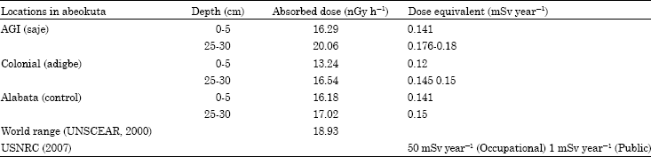
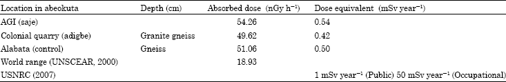
The results of the calculated absorbed dose rate and dose equivalents in the soils of the study area and its comparison with the world value (Table 7) has helped in highlighting the radiological health burden inherent in the soil environment while the calculated absorbed rate and dose equivalent in the different rocks of the abandoned quarry (Table 8) probably gave insight into the radiological health burden that can arise from quarry activities (i.e., occupational exposure) in the study area.
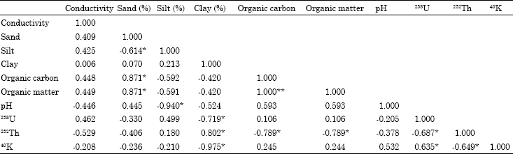
The statistical evaluation of the analyzed parameters in the study area indicated that there exist a highly positive correlation between organic matter and organic carbon (1.000) at 0.01 level of significance and a highly negative correlation between 40K and Clay (-0.975) at 0.05 level of significance for the surface soil samples (Table 9).
| Table 6: | Comparison of radionuclides ratios in the rocks and soils from abandoned quarries |
 | |
| Table 7: | Comparison of absorbed dose rates (nGy h-1) and dose equivalent (mSv year-1) in soil with world standards |
 | |
| Table 8: | Comparison of absorbed dose rate (nGy h-1) and dose equivalent (mSv year-1) in rock with world standard |
 | |
| Table 9: | Correlation of radionuclide and physicochemical parameters analyzed for the surface soil (0-5 cm) soil |
 | |
| *Correlation is significant at the 0.05 level (2-tailed). **Correlation is significant at the 0.01 level (2-tailed) | |
| Table 10: | Correlation of radionuclide and physicochemical parameters analyzed for the subsurface (25-30 cm) soil |
 | |
| *Correlation is significant at the 0.05 level (2-tailed). **Correlation is significant at the 0.01 level (2-tailed) | |
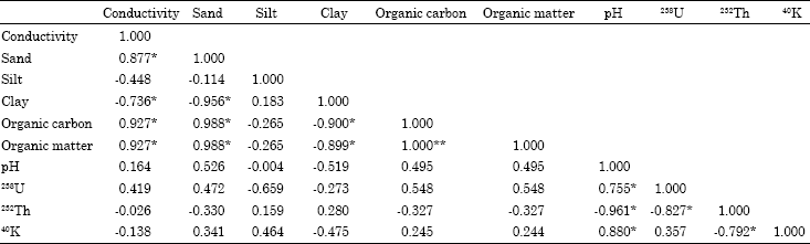
Similarly, from the subsurface soil samples (Table 10) there exist a highly negative correlation between sand and clay (-0.956) and 232Th and pH (-0.961) at 0.05 level of significance. All these negative values of correlation matrix are suggestive of external sources of the radionuclides in the study area. There exist a positive correlation between sand and organic carbon (0.988), sand and organic matter (0.988) at 0.05 significant level and a strong relationship between organic matter and organic carbon (1.000) at 0.01 level of significance.
DISCUSSION
Previous studies have shown that naturally occurring radionuclides become trapped in the earth’s crust during the formation of the parent rocks (Gessel and Prichard, 1975) and end up in soils as part of rock cycle through weathering (USEPA, 2007). It is also possible that the radionuclides may show a distinct variation in the radiation level in any environment based on the local geology of the area investigated. In this study, the observed relatively higher level of all the radionuclides in the granite rocks of the abandoned AGI quarry (Saje) compared with the gneissic rocks of the abandoned Colonial quarry site (Adigbe) and Non-quarry sites (Alabata) (Table 3) confirms the usual abundance of natural radionuclides in granite rocks as a parent rock than any other types of rocks.
Similarly, the reduced levels of the radionuclides in the gneissic rocks supports the fact that the original concentrations of 232Th, 238U and 40K in rocks may vary due to the alteration caused by metamorphic process (Verdoya et al., 2001). The observed 40K content of the analyzed rocks (i.e., granite and gneiss) of the abandoned quarry sites can be attributed to large amount of potassium (>90%) in granite rocks with only about 7% being radioactive (i.e., 40K) (Harenyama et al., 2006). On the basis of the physico-chemical analysis of the soils from the abandoned quarry and the control sites (Table 1, 2), the soils from the study area comprised dominantly of sand, silt and clay with the order of magnitude being sand%>clay%>silt%. These soils can be classified as loamy sand and sandy-clay using USDA classification (Miller, 1994). Soils are mostly acidic in all the locations (pH = 3.3-6.1) with the conductivity values in the range of 50.0 to 1670.0 μS cm-1 for both the surface and subsurface soils. Similarly, the soils from the abandoned quarry and the control site have relatively lower percentage organic carbon content (0.36-2.19%) and organic matter content (0.62-3.79%) in all the locations, a situation still within the conditions obtainable in the tropical region (Landon, 1984).
The soil characteristics in the study area must have been favourable to the accumulation of radionuclides as soil micronutrients. The relatively high radionuclides contents in the surface and subsurface soils (in particular 232Th and 40K) from the abandoned quarry sites can be linked with the higher percentage of silt and clay contents compared with the surface soil (Table 1, 2). Elevated levels of radionuclides in soils have been associated with finer materials such as silt and clay (Frederickson, 1948; Baeza et al., 1995). This has been statistically justified in this study by the strong and positive relationship between 238U and 40K (0.655) and strong but negative relationship between 238U and 232Th (-0.961) (-0.687); 232Th and 40K (-0.649) (-0.792) at essentially 0.05 level of significance. According to Doveton and Merriam (2004), such elevated concentrations of K and Th in the environment (i.e. including soil environment) are indicators of clay mineral abundance and composition. However, the mean radionuclide concentrations in both the surface and subsurface soils are generally lower than the mean radionuclide concentration in the rocks, a situation which inferred the geogenic provenance of the radionuclides in both the abandoned quarry and non-quarry sites. The variations in the mean radionuclide concentration in the soils and rocks across the different locations in this study can be related to the minerals composition of the bedrocks and extent of quarry activities. It also depends on the distribution of these isotopes in the rocks and the processes in which they are released (i.e., weathering, erosion and deposition).
The elevated concentration of 40K in both the surface and subsurface soils can be related to weatherability of the feldspar minerals-orthoclase K(AlSi3O4) and plagioclase Na(AlSi3O8)/Ca(Al2Si2O8) constituent of the granitic rock bodies in the study area.
The absorbed gamma doze rates obtained for the soils of the study area range from 13.24 to 20.06 nGy h-1 with a mean value of 16.47 nGy h-1 (Table 5) while the absorbed gamma doze rates in the soils of the study area ranged from 49.62 to 54.26 nGy h-1 with a mean value of 53.78 nGy h-1 (Table 6). The values of observed gamma doze rates in the soils of the study area have been found to be not only lower than that of the parent bedrocks in the study area but also lower than the range of 34.5 to 97.6 nGy h-1 with a mean of 66.8 nGy h-1 obtained for the soil of Serbia and Montenegro (Dragovic et al., 2006). The dose equivalent which is in the range of 0.12 to 0.17 mSv year-1 with a mean of 0.14 mSv year-1 obtained for the soils of the study area is higher than the value of 8.2x10⁻⁵ obtained for the soils of Canary Island. However, both the absorbed dose rates and dose equivalents for both the soil fall within the world range of 18-93 nGy h-1 (UNSCEAR, 2000) and recommended limits for the occupational exposure (50 mSv year-1) and exposure (1 mSv year-1) (USNRC, 2007).
CONCLUSIONS
The determination of radionuclide contents and concentrations in rocks and soils from the abandoned quarry and non-quarry sites carried out in this study confirmed the presence of 40K, 232Th and 238U in appreciable amount. The abundance of 40K in both the surface and subsurface soils samples have been linked to its elevated concentration in the rocks of the abandoned quarry and non-quarry sites. It is therefore likely that 40K will be the principal naturally occurring source of radiations in the study area.
Though, the maximum mean dose equivalent of 0.54 and 0.18 mSv year-1 obtained for rocks and soils of the study area respectively are lower than the allowable maximum limits of 1 mSv year-1 (Public) and 20 mSv year-1 (Occupational) but may have cumulative effects on the health of peasant workers in the abandoned quarry site (especially, the colonial quarry) majority of who have been there for more than 20 years.
Constant monitoring of the abandoned quarry sites and periodic education of the abandoned quarry workers is suggested as a temporary measure while reclamation of these abandone quarry sites will prevent future exposure of the populace to radiological effects.
REFERENCES
- Al-Jundi, J., B.A. Al-Bataina, Y. Abu-Rukah and H.M. Shehadeh, 2003. Natural radioactivity concentration in soil samples along the Amman Aqaba Highway, Jordan. Radiat. Meas., 36: 555-560.
CrossRef - Baeza, A., M. Del-Rio, A. Jiminez, C. Muro and J. Paniagna, 1995. Influence of geology and soil particle size on the surface area volume activity ratio for natural radionuclides. J. Radioanal. Nucl. Chem., 189: 289-299.
Direct Link - Belivermis, M., K. Onder, C. Yavuz and T. Sayhan, 2009. The effects of physicochemical properties on gamma emitting natural radionuclide levels in the soil profile of Istanbul. Environ. Monit. Assess.
CrossRef - Wang, C.J., S.Y. Lai, J.J. Wang and Y.M. Lin, 1997. Transfer of radionuclides from soil to grass in Northern Taiwan. Applied Radiation Isotopes, 48: 301-303.
CrossRef - Doveton, J.H. and D.F. Merriam, 2004. Borehole petrophysical chemostratigraphy of Pennsylvanian black Shales in the Kansas subsurface. Chem. Geol., 206: 249-258.
CrossRefDirect Link - Dragovic, S., L.J. Jankovic and A. Onija, 2006. Assessment of gamma dose rates from terrestrial exposure in Serbia and Montenegro. Radiat. Protec. Dosimetry, 121: 297-302.
Direct Link - Fasasi, M.K., P. Tchokossa, J.O. Ojo and F.A. Balogun, 1999. Occurrence of natural radionuclides and fallout cesium-137 in dry season agricultural land of South Western Nigeria. J. Radioanalyt. Nucl. Chem., 240: 949-952.
CrossRefDirect Link - Frederickson, A.F., 1948. Some mechanisms for the fixation of uranium in certain sediments. Science, 108: 184-185.
Direct Link - Fernandez, J.C., B. Robaym, A. Allendo, A. Poffijin and J. Thermandez-Armas, 1992. Natural radiation in tenerife (Canary Islands). Radiat. Protect. Dosimetry, 45: 545-548.
Direct Link - Florou, H. and P. Kritidis, 1992. Gamma radiation measurements and dose rate in the coastal areas of a Volcanic Island, Aegean Sea, Greece. Radiat. Prot. Dosim., 45: 277-279.
Direct Link - Gbadebo, A.M. and A.J. Amos, 2010. Assessment of radionuclide pollutants in bedrocks and soils from Ewekoro cement factory, Southwest Nigeria. Asian J. Appl. Sci., 3: 135-144.
CrossRefDirect Link - Harenyama, M., N. Tsuchiya, M. Takeba and T. Chida, 2006. Two dimensional measurement of radioactivity of Granite rocks by Photostimulated Luminiscence Technique. Geochem. J., 34: 1-9.
Direct Link - Karahan, G. and A. Bayulken, 2000. Assessment of gamma dose rates around Istanbul (Turkey). J. Environ. Radioact., 47: 221-231.
Direct Link - Mc-Aulay, I.R. and D. Morgan, 1988. National radioactivity in soil in Republic of Ireland. Radiation Prot. Dosimetry, 24: 47-49.
Direct Link - Nageswara-Rao, M.V., S.S. Bhatti, P. Rama-Seshu and A.R. Reddy, 1996. Natural radioactivity in soil and radiation levels of Rajasthan. Radiation Prot. Dosimetry, 63: 207-216.
Direct Link - Olomo, J.B., M.K. Akinloye and F.A. Balogun, 1994. Distribution of gamma-emitting natural radionuclides in soils and water around nuclear research establishments, Ile-Ife, Nigeria. Nucl. Instr. Methods Phys. Res. Sect. A: Acceler. Spectrom. Detect. Assoc. Equip., 353: 553-557.
CrossRefDirect Link - Sesana, L., M. Fumagalli, M. Carnevale, G. Polla and U. Facchini et al., 2006. Natural radionuclides in the rocks of the Valle del Cervo pluton in piedmont. Radiation Prot. Dosimetry, 118: 337-377.
PubMed - Tahir, S.N.A. and A.S. Alaamer, 2008. Determination of natural radioactivity in rock salt and radiation doses due to its ingestion. J. Radiol. Prot., 28: 233-236.
Direct Link - Tzortzis, M., E. Svoukis and H. Tsertos, 2004. A comprehensive study of natural gamma radioactivity levels and associated dose rate from surface soil in cyprus. Radiation Prot. Dosimetry, 109: 217-224.
Direct Link - Veiga, R., N. Sanches, R.M. Anjos, K. Macarioa and J. Bastosa et al., 2006. Measurements of natural radioactivity in Brazilian beach sands. Radiation Measeaure, 41: 189-196.
CrossRef