
Seyed A. Hosseini
Department of Forestry,
Karim Solaymani
Remote Sensing and GIS Centre, Mazandaran University, P.O. Box 737 Sari-Iran
Pakistan Journal of Biological Sciences
Year: 2006 | Volume: 9 | Issue: 11 | Page No.: 2055-2061


ABSTRACT
In this study, main factors for path tracing (Road selecting) were investigated to study principle-digitized maps including slope, slope direction, soil, volume per hectare and ecological capacity units using GIS techniques. Namkhaneh district in Kheyroud Forest (Training and Research Forest of Natural Resources Faculty of Tehran University) at the east of Nowshahr close to Caspian sea (Mazandaran province) due to complete and exact geographical information was selected as the area of this research. Digital maps were produced and analyzed by GIS and Arcview software. The maps of soil, slope, directions of slope, bedrock and volume per hectare were categorized and classified. So surface of each classes were classified in tables to divide the research area to different units for road selecting. Finally it was decided to select the best area to plan forest road with effective factors. To design the optimal forest road, we used the GIS techniques. It was concluded that using GIS and computerized analyzing cause to economize in time, costs and to minimize environmentally damages.
PDF Abstract XML References Citation
How to cite this article
Seyed A. Hosseini and Karim Solaymani, 2006. Investigation of Effective Factors for Path Tracing using GIS in Kheyroud Forest (Iran-Mazandaran Province). Pakistan Journal of Biological Sciences, 9: 2055-2061.
DOI: 10.3923/pjbs.2006.2055.2061
URL: https://scialert.net/abstract/?doi=pjbs.2006.2055.2061
DOI: 10.3923/pjbs.2006.2055.2061
URL: https://scialert.net/abstract/?doi=pjbs.2006.2055.2061
INTRODUCTION
The North forest of Iran needs to manage and to plan fundamentally by designing forest road network. Up to now, road planning was based on studying topography map and field. It is very important to know everything about area of road planning. According to the statistic data issued by Forest and Rangelands Organization of Iran (2000), only 7% of Iran covers by forests form which the portion of the North is less than 1%. Kind of Vegetation is the main factor for soil conservation, water storage, wild habitat and biotic storage, tourism, entertainment and recreation and finally as a productive resource has many material and spiritual values (Sarikhani and Madjnonian, 1996; Sarikhani, 2002). The road way grade should be carefully selected, not only to minimize the total road cost but also to reduce the environmental impact and to improve driver safety (Akay, 2005). An optimized plan can be considered as a design that is characterized by attributes of technical-economic environmental conception especially using GIS (Goudarzi, 1999; Hruza, 2003). Optimum planning of forest roads network is the basis and foundation for reasonable and practical preparation of forestry management and utilize it safely. Precise tracing of the path to plan the access roads networks for conservation and exploitation of the forest is the basis for forest management. Geographical information system can be used to gather all needed layers for selecting correct paths (Akay 2004). This system is used for a set of information series and modeling methods, which play their role through offering Geographical Information structure, analysis, offering quantitative information from geographic places in different forms and graphical and digital methods. Geographical Information System capabilities uses for reasonable decision making through increasing precision and decreasing expenses to implement path tracing and optimum recognition of the land (Makhdoum, 2003). A variety of studies in different fields of forestry, watershed management were implemented on the research area. In this research, fairly complete recognition of the strong areas to perform the path, slope map, geographical direction of the slopes, type of soil and bed rock, current type of trees, stock per hectare and finally their analysis were studied to assist us planning and designing Forest road environmentally and safely.
MATERIALS AND METHODS
Study area: It is located on the west of Nowshahr (Mazandaran Province, Training and Research Forest of Natural Resources Faculty of Tehran University), between North latitude of 36° 27’ and 36° 40’ and eastern longitude of 51° 32’ and 51° 43’ including 7 districts which their area figure out to 8800 hectares. A district with the area of 1075 hectares called Namkhaneh (Goudarzi, 1999). The precipitation rate fluctuates from 1300 to 1600 mm and the minimum rainfall occurs in the middle of summer. Its geological structure is made of limestone of the third era of geology and due to geomorphologic phenomena such as Dolin in the zone, there is a proper drainage all over this district. Five southeastern parcels out of 27 parcels in the study zone are so called protective parcels. They are excluded from the forest road network planning due to their excessive dip and their area amounts to 285 hectares. According to the statistics data the extent of main (First Degree) and tributary roads in Namkhaneh district amounts to 11.340 km, the length density of which is 14.36 (m ha-1).
Research method: The first step in through study was recognition of effective factors of the area for finding proper paths, which were processed in GIS software. Thus Arcview software was selected to produce maps and analyze database. In spite of the literature review and history of the research, the recognition of the study area soil, its bedrock and dip condition, geographical direction of the slopes, the amount of stock per hectare and the percent forest type were needed. So it was decided to collect them as digital information. Dip (slope) map and geographical directions of slopes were prepared using GIS capabilities and by Digital Elevation Model (DEM). Dip map was classified based on the percentage using topographic map of the zone and was extracted by Arcview software. By defining the geographical directions of the slopes in the software, its map was also achieved in separation with its classes. The type of different soils on the study zone was very important and extracted from the pedology studies of Kheyroud Forest (Sarmadyan and Djafari, 2001). Using the prepared digital maps for all districts of this Forest, the border of research district was separated in Arcview software and the map of soil types in Namkhaneh district and soil drainage condition were provided. Some of the characteristics were achieved from last Project booklet such as stock per hectare and tree types percent were used to produce some maps by Arcview software. After regulating achieved data and database from the study area, dip percentage maps, soil type and its drainage, percent type of the growing stock, number of trees per hectare and geographical directions of the slopes were composed and a number of ecological homogenous units were extracted.
RESULTS
After collecting information from the study zone, they were studied and then were processed using GIS capabilities in Arcview software, the following maps and tables were produced and extracted for further study and discussion:
| • | Digital map of the study zone topography (Fig. 1). |
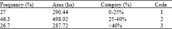
| • | Slope map separated into three classes (0-25, 25-40, >40%) (Fig. 2). |
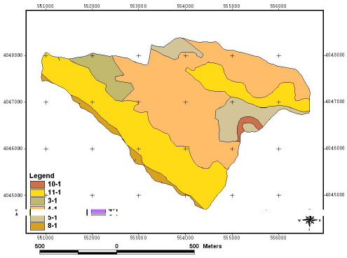
| • | The map of the geographical direction of slopes separated into five classes (North, South, East, West and Plate) (Fig. 3). |
| • | Map of the soil drainage condition, which was prepared, based on the map of soil types and classified into three categories (Good, Medium and Poor) (Fig. 4). |
| • | Map of present forest type was prepared using growing elements of the parcels and three major types were specified (Beech, Beech-Hornbeam and Hornbeam) (Fig. 5). |
| • | Map of volume per hectare using GIS capabilities (100-200, 200-350, 350-450, >450 m3) (Fig. 6). |
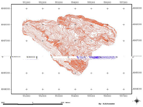 | |
| Fig. 1: | Topography map |
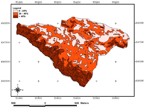 | |
| Fig. 2: | Slope map Kheyroud forest area |
 | |
| Fig. 3: | Soil map of Kheyroud forest area |
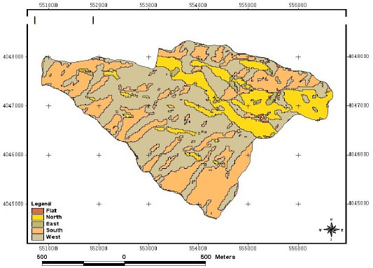 | |
| Fig. 4: | Aspect map of Kheyroad forest area |
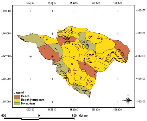 | |
| Fig. 5: | Forest type map of Kheyroud |
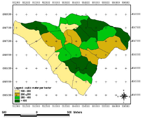 | |
| Fig. 6: | Volume per hectare map of Kheyroud forest area |
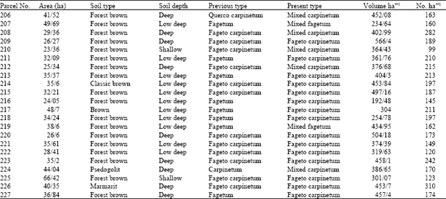
| Table 1: | Characteristics of the study area |
 | |
To study the effective factors for tracing the proper paths, the frequency rate of the areas of each specified class on the research area map was studied and the tables of the their codes cover areas were extracted:
| • | Characteristics table of the study zone parcels extracted from the forestry Project booklet (2002) are given in Table 1. |
| • | Based on topographic map of the study area (Fig. 1 and 2) surface of each slope class was determined (Table 2). |
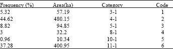
| • | According to the forest project booklet (Table 1) and soil condition on the study area, table of soil type factor and its characteristics are classified. |
Figure 4 and Table 3 showed that soil type was deep dark brown with fairly good drainage as the widest part of soil surface with 44.62%.
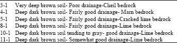
| • | Figure 3 was analyzed and each direction classified in Table 5. |
| Table 2: | Slope percentage factor, area and frequency percentage of each class |
 | |
| Table 3: | Percentage of soil type |
 | |
| Table 4: | Number of soil type based on Fig. 4 |
 | |
| Table 5: | Geographical direction factor, area and frequency percentage for each category |
 | |
| Table 6: | Volume per hectare, area and frequency percentage for each category |
 | |
Figure 3 and Table 5 showed that the most percent was western direction and Good condition about slope direction with 47.76%.
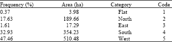
| • | Based on Table 1 (col.7) volume per hectare was arranged in Table 6. |
DISCUSSION
Investigation and studying of effective factors for path tracing in forest is very important environmentally and socio-economically (Goudarzi, 1999; Tan, 2000; Hruza, 2003). Precise tracing of the path to plan the access roads networks for conservation and exploitation of the forest is the basis for forest management (Sarikhani, 2002). According to the statistic data that issued by Forest and Rangelands Organization (2000) only 7000 km were constructed and used. Based on the total forest cover area in the north of Iran that is 1.9 million hectare, need to have 38000 (km) road optimally distributed with 20 m ha-1 length density. A long time and much money should be spend for this length of forest roads planning,. If we use new technology such as GIS technique, the information and exact data will prepare to analyze for path tracing. Effective factors including (DEM) Digital Elevation Model, soil map, bedrock map, drainage map were classified carefully. Figure 4 and Table 3 showed that soil type was deep dark brown with fairly good drainage as the widest part of soil surface with 44.62%. The major soil type was deep dark brown forest soil with fairly good drainage condition that was suitable for path tracing in this district. Figure 3 and Table 5 showed that the most percent was western direction and Good condition about slope direction with 47.76%. The bedrock was Marn about 44.6% (Table 4). Table 2 and Fig. 3 showed that the most slope percent was between 25-40% and geographical direction was West that was a dry side and drainage condition, infiltration of soil was good (Sarikhani, 2002; Modyri, 1999). So there was no treat to path selecting on most part of the study area. With these factors the costs of construction and maintenance were decreased logically the project line can be planned technically and environmentally, so low slope needs low cutting or filling then cost of soil transporting will be low. As a whole, it was concluded that research area had some effective factors to path tracing (road selecting) for planning forest roads. Finally, using GIS for identifying road selecting factors in mountain forest caused to increase precision decreasing expense in path tracing, building and maintenance (Acar, 1997; Amiri, 2000; Akay 2004). The most important of all was saving the time of performance and soil conservation. In this study, logical justification of precision of Geographical Information System was approved clearly.