
K. Soleimani
RS and GIS Center, University of Mazandaran, Iran
S. Modallaldoust
University of Mazandaran, P.O. Box 416, Babolsar, Iran
Journal of Applied Sciences
Year: 2008 | Volume: 8 | Issue: 8 | Page No.: 1495-1502


ABSTRACT
Soil erosion normally occurs at a very high level in most parts of Iran and can become a problem when human affects such as agricultural activities disturbed the ecological balance. Problems with erosion have become more apparent in recent decades owing to changes in land use, field sizes and soil management patterns. This study aims to find the relations between land management such as slope gradient with land use pattern and the erosion reduction in Jam and Riz basin. The materials used in this study included the basic maps of topography, geology, recent land use and IRS data that prepared the required information layers to assessment of erosion. The types of especial erosion calculated by the empirical method for the mentioned basin. The land use coefficient (Xa) was applied in the used model of EPM (Erosion Potential Model) to forecasting the effect of the land type to reduce the erosion. The results of this study indicated that the rangeland products a rate of especial erosion about 3074.8 (m3/km2 year) and the cropland products a rate of especial erosion about 1714.4 (m3/km2 year) which are respectively have minimum and maximum role in erosion for the study domain. In conclusion optimum land management reduced erosion in the study area up to 58.3%.
PDF Abstract XML References Citation
How to cite this article
K. Soleimani and S. Modallaldoust, 2008. The Effect of Land Suitability to Reduce Erosion Risks, Using GIS (Case Study; Boushehr Province, Iran). Journal of Applied Sciences, 8: 1495-1502.
DOI: 10.3923/jas.2008.1495.1502
URL: https://scialert.net/abstract/?doi=jas.2008.1495.1502
DOI: 10.3923/jas.2008.1495.1502
URL: https://scialert.net/abstract/?doi=jas.2008.1495.1502
INTRODUCTION
Erosion is one of the most significant forms of land degradation (soil truncation, loss of fertility, slope instability), greatly influenced by land use and management (Rey, 2003; Bini et al., 2006). Soil forming environments and erosion processes is a much-debated question when studying the relationship between human impact and environment change (Ballantyne and Wittingtone, 1999; Vanniere et al., 2003). The impact of human activities (farming, agro pastoral burning) on mechanical erosion is well-established (Higgitt et al., 1991; Lageras and Sandgren, 1994; Passmore and Macklin, 1994; Thornes, 1987). Other parameters, permanent or unvarying (size of watershed, lithology and relief) and variable factors (climate, hydrology, vegetation cover) have an effect on sediment yield and erosion rates (Meade, 1988; Milliman and Syvitski, 1992). Sediment yield also depends on dynamic agents such as gravity on slopes and running water (Maede et al., 1990). Land transformation is most in rural areas where expansion of unsustainable agriculture practices are contributing to an unprecedented rate of land degradation (Guzman, 1991; Van der Zaag, 1992; Vazquez-Garcia, 1993; Aide and Cavelier, 1994; Aide et al., 1995; Landa et al., 1997). For example, agricultural land use is one of the most important factors that have shaped historic landscapes in Europe (Black et al., 1998; Correia, 2000; Van Oost et al., 2000; Bickik et al., 2001; Van Rompaey et al., 2002; Sun et al., 2003; Bakker et al., 2004, 2005). Increasing agricultural exploitation of landscapes and associated land use changes have often led to soil quality degradation and loss of soil by erosion (Szilassi et al., 2006). Soil losses and sediment yields from cropped areas have been estimated several times greater than native forest (Neil and Fogarty, 1991). Conversion of landform range to agriculture has created and continues to produce, many on and off site problems for rural people living in watersheds which one of the most destructive and insidious processes occurring because of this anthropogenic activity, is soil erosion (Changhuan and Lixian, 1992; Miller, 1993; Morgan, 1995; Lal, 1997; Landa et al., 1997). The potential for surface runoff and soil erosion is accelerating by land use and cultivations. Therefore, the modeling of land use changes is important with respect to the prediction or soil degradation and it is on-site and off-site consequences. Many land use changes studies have shown that almost all land use changes are clearly by human activities (Turner et al., 1990; De Koning et al., 1998; Thornton and Jones, 1998). However, biophysical conditions of the land, such as soil characteristics, climate, topography and vegetation determine largely the spatial pattern of land use and land use changes (Veldkamp and Fresco, 1996). Li et al. (2002), in addition to introducing vegetation factors, soil, rainfall and land use as a main influential factors on erosion concluded that erosion in plough lands is 48 to 53%, in river basin is 22 to 25% and in pastures is 33 to 34%. Roose (1998) found that the amount of soil erosion in intact forests is lower which about 0.004 to 0.5 ton in hectare is yearly. However, erosion in forests turned to agricultural land is about 750 ton in hectare yearly. Palis (1990) states, proper actions for soil and water conservation, decrease the erosion and water wastage about 2 to 1000 and 1.3 to 21.7 times, respectively. Chandler and Walter (1998) studied the effect of five kinds land use in runoff creation and concluded that forest lands, turned lower than 3% of annual rainfall to surface runoff. Mulch farming converted about 13%; plough lands about 17%, cultivated lands about 31% and spoiled pasture about 76% of annual rainfall to surface runoff. Bodnar et al. (2006) in a study entitled ex-post evaluation of erosion control in Southern Mali, compared the erosion situation in a rural area from 1988 to 2003, so, in 2003 the farmers installed the stony rows on their lands and cultivated grass bands. Then started to plant in a direction was a perpendicular to a slope. This comparison showed that special reduction happened to gully erosion volume about 87% in farmland; this is, from 58 to 8 m3. Annual evaluation represented, the erosion value, depleted to 77%. That means, it reached from 42 to 10 ton in hectare, yearly. Methods for estimating sediment yield were first developed for the analysis of the effects of agricultural practices. The first model used was the Universal Soil Loss Equation or USLE (Wischmeier and Smith, 1965, 1978). The commonest models now being used are USLE (Mati et al., 2000; Erskine et al., 2002), MUSLE (Modified Universal Soil Loss Equation), WEEP (Water Erosion Prediction Project), RUSLE (Revised Universal Soil Loss Equation), (Millward and Mersey, 1999, 2001; Raghunath, 2002), PSIAC (Pacific Southwest Interagency Committee) (Nelson and Rasele, 1989; Heydarian, 1996; Clark, 2001) and EPM (Erosion Potential Method) (Tangestani, 2001). Gavrilovic (1988) originally developed the EPM model for Yugoslavia. The method has tested in some catchment areas in Iran and it is concerned that output results are compatible with field observation (Sadeghi, 1993; Refahi and Nematti, 1995). Applications of Geographic Information Systems (GIS) and remote sensing techniques in erosion and sediment yield assessment have been developed recently (Hill, 1993; Mezosi and Mucsi, 1993; Floras and Sgouras, 1999; Mohammed Rinos et al., 2001; Rafaelli et al., 2001; Shrimali et al., 2001; Bissonais et al., 2002; Lin et al., 2002; Sahin and Kurum, 2002; Yuliang and Yun, 2002; Martinez - Casasnovas, 2003; Tangestani, 2006; Modallaldoust, 2007; Modallaldoust et al., 2008). Remote sensing techniques assist the evaluation of erosion processes and the generation of land use maps, while the integration of such data layers with the generation of erosion - severity and sediment yield maps can readily be performed by the use of the analytical tools of GIS. In this study EPM model and analytical GIS tools used to the land management for erosion hazards reduce of the study area. Land use changes related to the slop factor is able to reduced the rate of erosion to 58/3 percentage.
MATERIALS AND METHODS
Jam and Riz basin is located in 25 km toward North Kangan and Jam town and 220 km from Southern part of Boushehr Port. The geographical location of the study area is indicated 51°, 48', 31.7'' E. to 52°, 25', 14'' E. and 27°, 44', 28'' N. to 28°, 14', 55'' N (Fig. 1).
Jam and Riz basin is surrounded with Zard kouh range in north and Sarkhan Mountain in North Eastern, Haft Chah, Takhteh Siah and Charm Ayne in Southeastern, Kachhar in South and Sarcheshme in Southern West. The only surface streams of Jam and Hramiaki flow in this area which is by end of spring after conjunction together are formed the main stream of Baghan and finally as the main branch joined to the Mond river. The area of the basin was estimated as 90919.2 ha using Arc GIS 9.2 software. The highest elevation of the study area shows 1414 m and its lowest elevation is 57.764 m from the sea level. Annual precipitation investigation shows that maximum precipitation in Baghan station have been 724.5 mm and minimum value in Ghantareh station have been 82 mm. The study of coefficient of variation represents disorderly rainfall in the region. Seasonal distribution of rainfall in the region, clears that rainfall regime is base on Mediterranean regime. It means, more than 60% of annual precipitation is in winter and summer with only 1% annual precipitation is driest season. Monthly precipitation regime represent that maximum rainfall happens in January and December, respectively. June and July are month with lowest rainfall. The methodology used in this study involved the effect of land management to reduce erosion risks using GIS, with the primary data obtained from topographic maps; Land sat ETM+ data, aerial photographic interpretation, field survey and earlier studies (Natural Resources of Boushehr Province, Iran, 2006). Information on soils, surface geology, land use, land slopes and climatic (mean annual rainfall and temperature) were used to assess the erosion severity. Derivation of the factors required by the EPM model is documented in the literature (Gavrilovic, 1988), however,the recent development of GIS and remote sensing technologies permits a more accurate estimation of some of the factors.
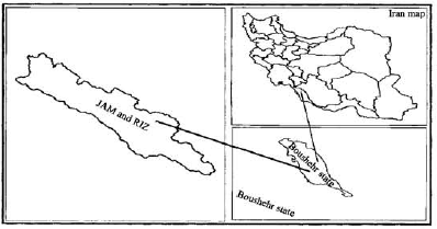 | |
| Fig. 1: | Geographic location of Jam and Riz watershed |
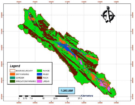 | |
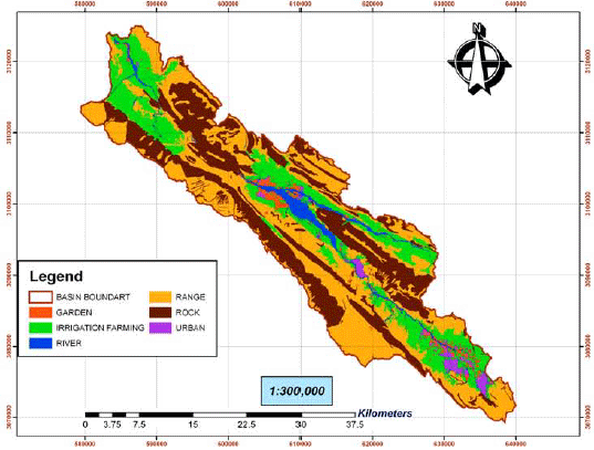
| Fig. 2: | Recent land use of Jam and Riz basin (Modallaldoust, 2007) |
The following sections describe the some techniques used to generate the data layer and to evaluate the erosion factors for EPM model based on the data layer.
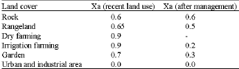
Land use: To determine the Xa-factor value utilized by the EPM method, land use map was generated by the use of Land sat Enhanced Thematic Mapper (ETM+) data in 2002 and Indian Remote Sensing (IRS) in 2004 (Fig. 2). Several enhancements and classification techniques were used, in conjunction with ground-truth data obtained from field excursions in 2006 and 2007, to delineate training areas of known land cover categories for the Jam and Riz basin. A maximum likelihood supervised classification (Campbell, 2002) was then performed using bands 1, 3, 4, 5 and 7 to recognize the unique spectral signatures associated with those land features. Small changes in land use had occurred between the time of collection of the satellite data and the field surveys. The land use coefficient (Xa) corresponding to each land use class was estimated by the use of EPM Guide Table (Gavrilovic, 1988). This model classifies land uses into 10 categories and evaluated the coefficient Xa from 0.1 (for high-density woodland) to 1.0 (for badlands). The study area classified to six categories and the land use coefficient was evaluated for each map class (Table 1).
Slope: Land slopes were calculated using 1:25000 topographic maps produced by the National Cartographic Center of Iran. Interpolation Tool in Arc GIS9.2 used the original digital data in Microstation Design (DGN) format to build up a DEM (Digital Elevation Model) of the study area (Soleimani and Modallaldoust, 2008). A raster grid cell of 50H50 m was generated and was applied to produce the DEM. The slopes were reclassified into 7 categories ranging from 0-5 to >50%.
| Table 1: | Land use coefficient (Xa) used in EPM model |
 | |
| Table 2: | Slope classes and the assigned I- factor of classes, used in EPM model |
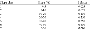 | |
The mean value of each slope class was assigned in decimal system (Table 2), to determine the I-factor (Gavrilovic, 1988). For suitable management, the land with less 15% slope as irrigation farming and more 15% slope as rangeland selected. Therefore estimated land use index was calculated for land and again was calculated the amount of erosion and sediment.
RESULTS AND DISCUSSION
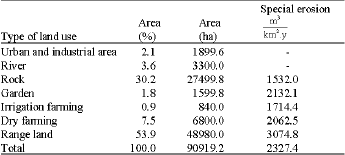
The results imply that after proper management, the whole erosion of basin has decreased up to 58.3% (Table 3, 4). The amount of special erosion for Jam and Riz current situation is about 2327.4 m3 kmG2 per year. If the management were appropriate, this amount will decrease up to 970.4 m3 kmG2 per year. This difference for all basin is equal to 1357 m3 kmG2 per year, which with considering total area of basin, erosion will deplete up to 1233773.5 m3, yearly. On the other hand, according to sediment delivery ratio, which is 44% for whole basin, the sediment of whole basin decreases 542860.4 m3 per year, which is notable. This means, the amount of basin erosion and sediment will decrease 2.4 times.
Referred to Fig. 2 and 3 that are presenting recent land use and after management it can be resulted that two major types of the changes happened such as dry farming to irrigation and rangeland to irrigation farming. The area with dry farming is concentrated in three main sections of upslope, middle part, down slope and through the main channels of the watershed. These mentioned types of the land used are suitable for the agricultural activities (Makhdoum, 2007). According to the filed investigation and extracted data from different sources, the land use conversion from dry farming to irrigation farming causes a sensible reduction of special erosion from 2062.5 to 423.2 m3 kmG2. According to (Fig. 2), we can observe that lands with dry farming and rangelands have located in margin of river of low slope areas.
| Table 3: | Erosion condition according to recent land use of Jam and Riz basin |
 | |
| Table 4: | Erosion condition according to land use after management of Jam and Riz basin |
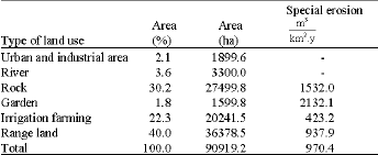 | |
These lands have the greatest amount of erosion and sediment, have been identified as a crisis and dangerous areas because of erosion and sediment creation and should be controlled. On the other hand, because these lands are in low slope of plain and are close to Baghan River, they have capability of turning to farm land. However, according to (Fig. 3), the farming pattern of these lands and able to change and results can be predicted after management. As you see in (Fig. 3), after management and changing farming pattern, great part of lands through the main channel and low slope plains have turned to irrigation farming. Irrigation farming in current land use map have area about 840 ha which have almost allocated 9% of basin area to themselves. Due to their little extent, they have high erosion about 1714.4 m3 kmG2 yearly. In fact, as in Fig. 2, parts of this irrigation farming of basin are not located in proper zones, which by adequate management, that these lands must convert to range lands. Results indicate after changing the land use, the extent of irrigation farming will decrease up to 20241.5 ha, i.e., about 22.3% of total basin area. There fore, because these lands are located in suitable place, the erosion resulting these lands decrease up to 423.4 m3 kmG2 per year. By this method, the area of basin’s rangelands, which have allocated about 53.9% of total area, decreases and reaches to 40%. This area depletion means omission of unsuitable and erosive areas. So that, by changing unsuitable ranges lands to livestock grazing, the erosion have been decreased from 3074.8 to 937.9% per year.
 | |
| Fig. 3: | Land use map after management, Jam and Riz basin |
Finally, observing tables and mention to figures, it can be concluded that the pattern of dry farming in under studied area is not adequate and must be removed. Changing cultivation pattern with proper management is a process can be accomplished easily and needs new methods and public intention for more and better application of resources. As you saw in results, alteration and reformation of land use in the field of reducing the erosion amount will be effective. Therefore, in order that management be applicable, using following cases are important:
| • | Necessity of changing the kinds of land use or take actions for prevention of same unwanted alters in lands. Residents of area must accept this subject. By this way, the most appropriate pattern can be accessible. |
| • | Public and policy makers= intentions to carry out legal performances in the field of enacting and executing laws. Without adjusting with executive organizations and policy makers= support, the plan would fail. |
Following suggestions are results from this research:
| • | Before any changes in land use, current map of land application must be compared with land use planning map in which lands capabilities and symmetry factors are regarded and then changes in land use be performed. |
| • | Systematic and integrated planning must be done for training and development of change methods and optimized land use. |
| • | Changing land use, which has formed according to land potential and capability, must be prevented. |
REFERENCES
- Aide, T.M. and J. Cavalier, 1994. Barriers to low land tropical forest restoration in the Sierra Nevada de Santa Marta, Columbia. Restoration Ecol., 2: 219-229.
CrossRef - Aide, T.M., J.K. Zimmerman, L. Herrera, M. Rosario and M. Seran, 1995. Forest recovery in abandoned tropical pastures in Puerto Rico. For. Ecol. Manage., 77: 77-86.
CrossRef - Bakker, M.M., G. Govers and M.D.A. Rounsevell, 2004. The crop productivity-erosion relationship: An analysis based on experimental work. Catena, 57: 55-76.
Direct Link - Bakker, M.M., G. Govers, C. Kosmas, V. Vanacker, K. van Oost and M.D.A. Rounsevell, 2005. Soil erosion as a driver of land use change. Agric. Ecosyst. Environ., 105: 467-481.
Direct Link - Ballantyne, C.K. and G. Wittingtone, 1999. Late Holocene flood plain incision and alluvial fan formation in the central Grampian High lands, Scotland: Chronology, environment and implications. J. Q. Sci., 14: 651-671.
CrossRef - Bickik, I., L. Jelecek and V. Stepanek, 2001. Land use changes and their social driving forces in Czechia in the 19th and 20th centuries. Land Use Policy, 18: 65-73.
Direct Link - Bini, C., S. Gemignani and L. Zilocchi, 2006. Effect of different land use on soil erosion in the pre-alpine fringe (North-East Italy): Ion budget and sediment yield. Sci. Total Environ., 369: 433-440.
Direct Link - Bissonais, Y.L., C. Montier, M. Jamagne, J. Daroussin and D. King, 2002. Mapping erosion risk for cultivated soil in France. Catena, 46: 207-220.
Direct Link - Black, E.A., E. Strand, G.R. Wright, M.J. Scott, P. Morgan and C. Watson, 1998. Land use history at multiple scales: Implications for conservation planning. Landscape Urban Plann., 43: 49-63.
CrossRef - Bodnar, F., W. Spaan and J. Hulshof, 2007. Ex-post evaluation of erosion control measures in Southern Mali. Soil Tillage Res., 95: 27-37.
Direct Link - Chandler, D.G. and M.F. Walter, 1998. Runoff responses among common land uses in the uplands of Matalom, Leyte, Philippines. Trans. ASAE, 41: 1635-1641.
CrossRefDirect Link - Correia, P.T., 2000. Future development in portuguese rural areas: How to manage agricultural support for landscape conservation?. Landscape Urban Plann., 50: 95-106.
Direct Link - De-Koning, G.H.J., A. Veldkamp and L.O. Fresco, 1998. Land use in Ecuador: A statistical analysis at different aggregation levels. Agric. Ecosyst. Environ., 70: 231-247.
CrossRef - Erskine, W.D., H.A. Mahmoudzadeh and C. Myers, 2002. Land use effects on sediment yields and soil loss rates small basins of Triassic sand stone near Sidney, NSW, Australia. Catena, 49: 271-287.
Direct Link - Floras, S.A. and I.D. Sgouras, 1999. Use of geoinformation techniques in identifying and mapping areas of erosion in a hilly landscape of central Greece. Int. J. Applied Earth Obser. Geoinform., 1: 68-77.
CrossRef - Higgitt, S.R., F. Old field and P.G. Appleby, 1991. he record of land use change and soil erosion in the late Holocene sediments of the Petit Lac d'Annecy, Eastern France. The Holocene, 1: 14-28.
CrossRefDirect Link - Lageras, P. and P. Sandgren, 1994. The use of mineral analysis in identifying middle and late Holocene agriculture-a study of peat profiles in Smaland, Southern Sweden. J. Archeol. Sci., 21: 687-697.
CrossRef - Landa, R., J. Meave and J. Carabias, 1997. Environmental deterioration in rural Mexico: An examination of the concept. Ecol. Appl., 7: 316-329.
Direct Link - Li, D., L. Sheng-wen, S. Pen-Ju and Z. Li-Ping, 2002. The research on relation between land resources utilization and water and soil conservation in developing the West of China. Proceedings of the 12th International Soil Conservation Organization Conference, May 26-31, 2002, Beijing, China, pp: 1-19.
Direct Link - Lin, C.Y., W.T. Lin and W.C. Chov, 2002. Soil erosion prediction and sediment yield estimation: The Taiwan experience. Soil Tillage Res., 68: 143-152.
Direct Link - Martinez-Casasnovas, J.A., 2003. A spatial information technology approach for the mapping and quantification of gully erosion. Catena, 50: 293-308.
CrossRefDirect Link - Mati, B.M., R.P.C. Morgan, F.N. Gichuki, J.N. Quinton, T.R. Brewer and H.P. Liniger, 2000. Assessment of erosion hazard with the USLE and GIS: A case study of the Upper Ewaso Ng=iro North basin of Kenya. Int. J. Applied Earth Observ. Geoinform., 2: 78-86.
Direct Link - Milliman, J.D. and J.P.M. Syvitski, 1992. Geomorphologic/tectonic control of sediment discharge to the ocean: The importance of small mountainous rivers. J. Goel., 100: 525-544.
CrossRefDirect Link - Millward, A.A. and J.E. Mersey, 1999. Adapting the RUSLE to model soil erosion potential in a mountainous tropical watershed. Catena, 38: 109-129.
CrossRef - Millward, A.A. and J.E. Mersey, 2001. Conservation strategies for effective land management of protected areas using an erosion potential information system (EPIS). J. Environ. Manage., 61: 329-343.
Direct Link - Passmore, D.G. and M.G. Macklin, 1994. Provenance of fine-grained alluvium and late Holocene land-use change in the Tyne basin, Northern England. Geomorphology, 9: 127-142.
CrossRefDirect Link - Rafaelli, S.G., D.R. Montgomery and H.M. Greenberg, 2001. A comparison of thematic mapping of erosional intensity to GIS-driven process models in an Andean drainage basin. J. Hydrol., 244: 33-42.
Direct Link - Rey, F., 2003. Influence of vegetation distribution on sediment yield in forested marly gullies. Catena, 50: 549-562.
Direct Link - Sahin, S. and E. Kurum, 2002. Erosion risk analysis by GIS in environmental impact assessment: A case study-Seyhan Kopru dam construction. J. Environ. Manage., 66: 239-247.
Direct Link - Soleimani, K. and S. Modallaldoust, 2008. Production of optimized DEM using IDW interpolation method. J. Applied Sci., 8: 104-111.
CrossRefDirect Link - Shrimali, S.S., S.P. Aggarwal and J.S. Samra, 2001. Prioritizing erosion-prone area in hills using Remote Sensing and GIS-A case study of the Suknna Lake sub catchment, Northern India. Int. J. Applied Earth Observ. Geoinform., 3: 54-60.
Direct Link - Sun, B., S. Zhou and Q. Zhao, 2003. Evaluation of spatial and temporal changes of soil quality based on geostatistical analysis in the hill region of subtropical China. Geoderma, 115: 85-99.
Direct Link - Szilassi, P., G. Jordan, A. van Rompaey and G. Csillag, 2006. Impacts of historical land use changes on erosion and agricultural soil properties in the Kali Basin at Lake Balaton, Hungary. Catena, 68: 96-108.
Direct Link - Tangestani, M.H., 2006. Comparison of EPM and PSIAC models in GIS for erosion and sediment yield assessment in a semi-arid environment: Afzar Catchment, Fars province, Iran. J. Asian Earth Sci., 27: 585-597.
CrossRefDirect Link - Thornton, P.K. and P.G. Jones, 1998. A conceptual approach to dynamic agricultural land-use modelling. Agric. Syst., 57: 505-521.
CrossRefDirect Link - Vanniere, B., G. Bossuet, A.V.W. Simonet, E. Gautheir and P. Barral et al., 2003. Land use change, soil erosion and alluvial dynamic in the lower Doubs Valley over the 1st millennium AD (Neublans, Jura, France). J. Archeol. Sci., 30: 1283-1299.
Direct Link - Van-Oost, K., G. Govers and P. Desmet, 2000. Evaluating the effects of changes in landscape structure on soil erosion by water and tillage. Landscape Ecol., 15: 577-589.
Direct Link - Van-Rompaey, A.J.J., G. Govers and C. Puttemans, 2002. Modeling land use changes and their impact on soil erosion and sediment supply to rivers. Earth Surface Processes Landforms, 27: 481-494.
Direct Link - Veldkamp, A. and L.O. Fresco, 1996. CLUE: A conceptual model to study the conversion and its effects. Ecol. Model., 85: 253-270.
CrossRef - Yuliang, Q. and Q. Yun, 2002. Fast soil erosion investigation and dynamic analysis in the loess plateau of China by using information composite technique. Adv. Space Res., 29: 85-88.
CrossRefDirect Link