
P.S. Roy
National Remote Sensing Agency, Hyderabad 500037, India
A. Giriraj
Department of Biogeography, University of Bayreuth, Bayreuth-95440, Germany
Journal of Applied Sciences
Year: 2008 | Volume: 8 | Issue: 8 | Page No.: 1346-1353


ABSTRACT
Information on land use/land cover in the form of maps and statistical data is very vital for spatial planning, management and utilization of land. Land-Use and Land-Cover (LULC) scenario in India has undergone a radical change since the onset of economic revolution in early 1990s. These changes involve a series of complex interaction between biophysical and socioeconomic variables. LULC follows a set of scientific themes which includes detection and monitoring, carbon and biogeochemical cycle, ecosystems and biodiversity, water and energy cycle, predictive land use modeling and climate variability and change. With the changing times and increasing demand on the availability of information on land use/land cover, it becomes necessary to have a standard classification system, precise definition of land use/land cover and its categories, uniform procedures of data collection and mapping on different scales over Indian region. The current review thus attempts to focus on development of a national goal towards changes in LULC as a necessary step for an interdisciplinary research program involving climate, ecological and socioeconomic drives, the processes of change and the responses and consequences of change.
PDF Abstract XML References Citation
How to cite this article
P.S. Roy and A. Giriraj, 2008. Land Use and Land Cover Analysis in Indian Context. Journal of Applied Sciences, 8: 1346-1353.
DOI: 10.3923/jas.2008.1346.1353
URL: https://scialert.net/abstract/?doi=jas.2008.1346.1353
DOI: 10.3923/jas.2008.1346.1353
URL: https://scialert.net/abstract/?doi=jas.2008.1346.1353
INTRODUCTION
India is bestowed with valuable natural resources serving the needs of sustenance of around a billion population and varied ecological functions. Since independence the population has increased by 284% (363 to 1033 Million) and food grain production by 386% (51 to 196 Million Ton). The country has 150 Million ha of agricultural area and about 24% GDP is met from the agricultural production. The loss of forest cover in India for the period between 1990 and 2000 is 380.89 km2, annually (FAO, 2000). The forests are integrated with social system for their dependence for fuel wood, fodder, minor forest products and timber. Fuel wood stands as the main stay of energy resource for 70% of Indian population and 125 Million Ton are extracted annually. In addition over half of the live stock population (270 million) depends on forest for grazing resources and NTFP worth of Rs. 6.5-20 billion is met annually from forest.
Information on land use/land cover in the form of maps and statistical data is very vital for spatial planning, management and utilisation of land for agriculture, forestry, pasture, urban-industrial, environmental studies, economic production etc. Today, with the growing population pressure, low man-land ratio and increasing land degradation, the need for optimum utilization of land assumes much greater relevance. The draft outline on the National Land Use Policy and strategy on Optimum Land Use Planning and the creation of National Land Use Conservation Board (NLUCB) in 1985 clearly indicate the serious concern of the Government in this regard. Further, with the present thrust that the agricultural planning in the country should be based on agro-climatic zones, the prima-facie need is to have a comprehensive information on the spatial distribution pattern of land use/land cover, particularly on the availability of agricultural land during Kharif and Rabi crop seasons, cropped area during both seasons and area under fallow, apart from the other land use/land cover classes. Besides, it is also required to know their area for the whole country covering all the 15 agro-climatic zones in the 442 districts (now the number of districts are 584). This needs land use inventory surveys periodically, to make available the information on the type, spatial distribution, location, aerial extent, rate and pattern of change of each category of land use/land cover. Preparation of an up to date, accurate and reliable information on land use/land cover over large areas on a contiguous basis is possible using remote sensing techniques on an operational, timely and on a cost effective basis.
Today, the availability of information on land use/land cover in the form of thematic maps, records and statistical figures are inadequate and do not provide an up to date information on the changing land use patterns and processes. Over the years, the efforts made by the various Central/State Government Departments, Institution/Organizations etc., is sporadic and often efforts are duplicated. In most the cases, as the time gap between reporting, collection and availability of data is more, the data often becomes out-dated. However, the organisational efforts in publishing maps, reports and statistical data by the Survey of India (SOI), National Atlas and Thematic Mapping Organization (NATMO), National Bureau of Soil Survey and Land Use Planning (NBSS and LUP), All India Soil and Land Use Survey (AIS and LUS), Central Arid Zone Research Institute (CAZRI), Ministry of Agriculture, Settlement Survey and Land Records, Revenue Department, National Sample Survey, State Land Use Boards, Town and Country Planning Organization (TCPO) and other local agencies are noteworthy.
The Indian experience on use of satellite data for Land Use/Land Cover analysis mainly comes from studies conducted at National Remote Sensing Agency (NRSA) in collaboration with different agencies. However, the mapping is carried out for specific objective and different time frame. Mapping on uniform scale with acceptable classification scheme is more than desirable.
LAND USE/LAND COVER
Land use is influenced by economic, cultural, political, historical and land-tenure factors at multiple scales. Land cover, on the other hand, is one of the many biophysical attributes of the land that affect how ecosystems function (Turner et al., 1995).
Land use referred to as man’s activities and the various uses which are carried on Land. Land cover is referred to as natural vegetation, water bodies, rock/soil, artificial cover and others resulting due to land transformation. Since both land use/land cover are closely related and are not mutually exclusive they are interchangeable as the former is inferred based on the land cover and on the contextual evidence.
Land use/land cover classification system: With the changing times and increasing demand on the availability of information on land use/land cover, it becomes necessary to have a standard classification system, precise definition of land use/land cover and its categories, uniform procedures of data collection and mapping on different scales for all the States and Union Territories.
Realizing the need for an up to date nationwide land use/land cover maps by several departments in the country, as a prelude, a land use/land cover classification system (with 24 categories up to Level-II, suitable for mapping on 1:250,000 scale) was developed by NRSA, DOS, taking into consideration the existing land use classification adopted by NATMO, CAZRI, Ministry of Agriculture, Revenue Department, AIS and LUS etc. and the details obtainable from satellite imagery. The classification system provided the conceptual frame-work for discussions with nearly 40 user departments/institutions in the country and finalizes acceptable 22 fold classification system which was adopted for Nationwide Land Use/Land Cover Analysis.
Land use/land cover analysis: The multi-date satellite data was analyzed to identify and map the details of crop land in kharif and rabi seasons, the area under double crop (during kharif and rabi seasons), fallow lands, different types of forest, degradation status, wasteland, waterbodies etc. NRSA with the help of Regional Remote Sensing Service Centres (RRSSC’s), State Remote Sensing Centres and other institutions completed this task using hybrid methodology i.e., visual as well as digital methods. Out of 442 districts in the country, 274 districts are analyzed using visual techniques and remaining 168 districts by digital techniques. For digital analysis considering the project requirements different software modules were developed and integrated to the commercially available image analysis software.
Reconciliation of area statistics generated by remote sensing and ground based techniques: The land use/land cover area statistics derived from satellite data at the district level for the base year 1988-89 were compared with the figures published by the Bureau of Economics and Statistics, Directorate of Economics and Statistics (DES), Ministry of Agriculture (MOA), Government of India, for the same period for consistency and compatibility. Firstly, the comparison was made by matching the different land use classes in both to one-to-one common group and secondly by comparing the definitions/explanations of each class with respect to the ‘Nine-fold Classification’ on the land utilization adopted by BES and DES/MOA. On comparison, difference in areas were noticed with respect to the Net Area Sown (NAS), land put to non-agricultural use and pasture land. But the major difference in area was observed with respect to net area sown and land put to non-agricultural use.
The results of the sample survey carried during 1992-93 years had indicated that the area under NAS shown in the village records is under reported to the extent of 10-15%. The survey also showed that the area under non-agricultural use derived from remote sensing is less by 3 to 5% compared to the reported area by BES. This is due to the omission of small water bodies and transport network (small scale of mapping and resolution of satellite data used) and commission of their area under dominant land use class, i.e., agriculture. Hence, 5% of area from agriculture land has been added to the area under non-agriculture use for comparison. The pasture land was non-existent on ground, may be due to conversion of such areas to agriculture over a period of time.
NATIONAL WASTELANDS INVENTORY PROJECT (NWIP)
Until recently, no attempt had been made to prepare a comprehensive map on any scale showing the distribution of different types of wastelands in India. A number of organizations and agencies commenced the collection and collation of data on the type and extent of wastelands. The area reported by various government agencies are varies from 38 to 175 Million Ha. The considerable variation in the area underscores the need to prepare a reliable database using the latest techniques of satellite remote sensing and geomatics.
In 1985, the National Remote Sensing Agency (NRSA) of the Department of Space prepared wasteland maps of all the Indian states and union territories at a 1:1 million scale. The total area of wastelands in 1980-1982 estimated through this study was about 53.3 million ha or 16.2% of the area of the country. The 1:1 million scale wasteland maps of the states and union territories of India provided only a gross estimate of wasteland area. Due to the small scale and relatively poor resolution of the MSS imagery, wasteland areas of less than 100 ha could not be mapped. Further more, it was found that the maps were of little use in reclamation planning at the local level. In 1985, National Wastelands Development Board (NWDB) was setup with the objective of rehabilitating 5 million ha of land each year for fuel wood and fodder production through a massive programme of seeding and afforestation. This programme required a very reliable database that provided details on the type, extent, location and ownership of wastelands.
Wasteland classification: Confronted by varying estimates of the extent of wasteland, including the NRSA figure based on remote sensing, it became evident that the NWDB had to provide precise definitions of the various categories of wasteland. The Technical Task Force established by the NWDB proposed a classification system consisting of thirteen categories of wasteland. The 1:1 million wasteland maps prepared by NRSA showed that 146 districts had wastelands covering more than 15% of their area. These districts were considered as critical (except for border districts) and selected for detailed mapping in Phases I and II (1986-89). In Phase III (1990-92), districts having 5 to 15% coverage of wasteland were mapped and in Phase IV (1992-93) the remaining seven districts of Madhya Pradesh were examined. Under Phase-V the rest of the country was completed.
Since the workload in the project was enormous, all the State Remote Sensing Centres and some central organizations were involved in the mapping task. In order to maintain a consistent standard and a uniform system, a manual of wasteland mapping procedures was prepared giving details of mapping and final drawing. Training workshops were organized at NRSA to instruct all the scientists involved in the project.
FOREST/VEGETATION COVER ANALYSIS
Using landsat MSS data of 1972-75 and 1980-82 periods, National Remote Sensing Agency (1989, 1985) carried out vegetation mapping on 1:1 million scale for the entire country, which showed a substantial decrease in forest cover. Subsequently, Forest Survey of India (FSI), Ministry of Environment and Forests (MOEF) carried out mapping of India for the year 1981-83 which was published in the year 1987. Since 1987, the forest cover of the country is being assessed biennially by Forest Survey of India (FSI) using remotely sensed data. FSI has carried out seven such surveys using satellite imagery and as per the latest available report of FSI (State of Forest Report, 2001) the total forest cover amounts to only 19.39% of the geographical area of the country. This is an alarmingly low figure considering that the National Forest Policy 1952 recommended 33.3% are of the country to be under forests. The same was reiterated in the National Forest Policy 1988. In the hilly and mountainous regions, the National Forest Policy recommends maintaining two-thirds of the area under forest or tree cover in order to prevent erosion and land degradation and to ensure stability of the fragile eco-systems.
The net increase in the forest cover of the country is 3,896 km2. The dense forest has increased by 10,098 km2 and mangrove by 44 km2, where as open forest has decreased by 6,246 km2. The forest cover in different state and union territories in the present and preceding assessments reveals that the states of Andhra Pradesh, Arunachal Pradesh, Delhi, Gujarat, Haryana, Himachal Pradesh, Jammu and Kashmir, Karnataka, Madhya Pradesh, Maharashtra, Orissa, Punjab, Rajasthan, Tamil Nadu, Tripura, Uttar Pradesh and West Bengal have registered increase in the forest cover. The states and the Union Territories showing decrease in forest cover area Assam, Bihar, Goa, Kerala, Manipur, Meghalaya, Mizoram, Nagaland, Sikkim, And3aman and Nicobar Islands and Dardra and Nagar Haveli. In Chandigarh and Daman and Diu there was no change in the forest cover during these two assessments (State of Forest Report, 2001).
Land cover mapping using SPOT-VEGETATION for South central Asia: Global Land Cover (GLC) 2000 is an initiative to make Global Land Cover data sets available for the researchers involved in Global/Regional Studies for land surface parameterization. It is a major project of European Commission-Joint Research Centre (JRC), Italy with an objective to provide a uniform and consistent data set comparable across the regions and countries for a reference year 2000. Indian Institute of Remote Sensing (IIRS), Dehradun, India has carried out a study for South Central Asian Region as part of this programme. The study has been executed with a participation of network support from countries like China, Sri Lanka, Myanmar, Thailand, Bhutan, Nepal and Bangladesh. The study has produced land use/land cover map for South Central Asian Region using SPOT-4 VEGETATION and other ancillary information.
The daily SPOT-4 VEGETATION data has been used to produce five day Normalized Difference Vegetation Index (NDVI) composite. Based on the five day NDVI composite, monthly maximum NDVI composite for nine months (except for rainy season) have been generated. The phonological variations of vegetation types have been used as discriminant. The land use/land cover along with Vegetation Index has been mapped based on ISODATA clustering algorithm using Land Cover Classification Scheme (LCCS) designed by United Nations-Food and Agricultural Organisation (FAO).
Biome level characterization of Indian vegetation using IRS-WiFS data: Realizing the potential of the IRS-1C datasets for regional level mapping, the assessment of phenological growth of vegetation in forest ecosystem has been attempted in the present study under ISRO-GBP programme by Indian Institute of Remote Sensing (IIRS), Dehradun (IIRS, 2004b). The climatic data with bio geographic map is used to delineate the biomes in the Indian Sub continent. The product will offer the basics inputs for the eco physiological processes. The maps serve a specific purpose in natural resource planning and decision making at landscape or regional level.
Vegetation and land use and land cover using IRS WiFS data: Realizing the importance of LULC over a period of time, regional level mapping has been attempted in India using IRS WiFS data to bring out causes, rates, magnitude, patterns and trends in landscape changes. Earlier studies have demonstrated substantial contribution of RS and GIS techniques to map spatial distribution of important habitats (Roy and Tomar, 2001; Amarnath et al., 2003; Roy and Behera, 2005). IIRS (2004a) has clearly brought out 36 LULC classes with description of 17 vegetation cover types and has accounted 18% of forest area remaining being the agriculture and/or other land uses. IIRS (2004b) used daily SPOT-4 VEGETATION data to produce NDVI based vegetation and LULC map for South central Asia. These inputs forms the primary basis for studies on regional climatic variations, accounting changes in deforestation/degradation, forest fragmentation, carbon flux, evapotranspiration, LAI, NPP assessment and regional ecosystem functioning and monitoring.
ASPECTS OF LULC CHANGES AND MODELING
Models on land use and land cover change are powerful tools that can be used to understand and analyze the important link age between socio-economic processes associated with land development, agricultural activities and natural resource management strategies and the ways that these changes affect the structure and function of ecosystems (Fig. 1). Long term understanding on LULC need to propose a more dynamic framework that explicitly links what is often divided into separate natural and human systems into a more integrated model. In developing countries like India, scenario are likely land use and land cover are often semantically equivalent i.e., land use activities associated with logging leads to a deforested land cover (Lambin, 1997). Therefore, satellite images can often be used to detect land use change through observations of the biophysical characteristics of the lands. Contrastingly developed countries like USA, Europe LULC are less likely to be equivalent. Although, forestry can be modeled as a land use activity that responds to economic, social and demographic drivers (Mauldin et al., 1999; Geist and Lambin, 2002a) such drivers do not provide direct predictors for understanding and modeling the amount and locations of forests and tree cover in all parts of a landscape.
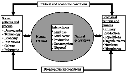 | |
| Fig. 1: | Conceptual Framework for Investigating Human Ecosystems (Agarwal et al., 2001) |
LULC modeling: Summarizing a large number of case studies, we find that land-use change is driven by a combination of the following fundamental high level causes:-resource scarcity leading to an increase in the pressure of production on resources, changing opportunities created by markets, outside policy intervention, loss of adaptive capacity and increased vulnerability and changes in social organization, in resource access and in attitudes. Currently review highlights as many as 19 land use change models for their spatial, temporal and human decision-making characteristics for comparing and reviewing land use change models (Agarwal et al. 2001). The models surveyed are:
| • | General Ecosystem Model (GEM) (Fitz et al., 1996) |
| • | Patuxent Landscape Model (PLM) (Voinov et al., 1999) |
| • | CLUE Model (Conversion of Land Use and Its Effects) (Veldkamp and Fresco, 1996) |
| • | Area base model (Hardie and Parks, 1997) |
| • | Univariate spatial models (Mertens and Lambin, 1997) |
| • | Econometric (multinomial logit) model (Chomitz and Gray, 1996) |
| • | Spatial dynamic model (Gilruth et al., 1995) |
| • | Spatial Markov model (Wood et al., 1997) |
| • | CUF (California Urban Futures) (Landis and Zhang, 1998) |
| • | LUCAS (Land Use Change Analysis System) (Berry et al., 1996) |
| • | Simple log weights (Wear and Bolstad, 1998) |
| • | Logit model (Wear et al., 1996) |
| • | Dynamic model (Swallow et al., 1997) |
Towards this, a series of recent papers, reports and workshops have been carried out by members of LUCC and other research community (Turner et al., 1995; Moran, 2000; Laurance et al., 2001; McConnell and Moran, 2001; Nepstad et al., 2001; Pontius et al., 2001; Van der Veen and Rotmans, 2001; Veldkamp and Lambin, 2001; Alves, 2002; Geist and Lambin, 2002b; Soares-Filho et al., 2002, 2004; Leemans et al., 2003; Pontius and Batchu, 2003). Reviews that characterize and classify land use models are provided by Kaimowitz and Angelsen (1998) and Lambin et al. (2003) for deforestation, while Bockstael and Irwin (2000) gave explanation of land use models based on economic theory. We thus argue that models of land use change can be linked with critical land cover outcomes (like forest cover) through the use of land cover transition models (e.g., Markov) to understand land use condition and land use change. Deriving such estimates from models of LU and LUC in time and space, which are driven by exogenous variables, for the assessment of future forest cover impacts of economic, social and policy changes would be useful for land use managers and policy makers.
LULC IN INDIAN SCENARIO
Initial knowledge on extrinsic and intrinsic factors operating at different spatial and temporal scales an alarming needs to be developed for quantifying LULC changes. In the past few decades there is change in land use, because of expansion of mining areas, increment in construction of dams, industrialization, urbanization etc. to name a few which affect the areas as an external factors. Internal changes includes shifting cultivation areas, selective logging due to human pressure on forest resources and habitat loss of wildlife due to reduction in the forests.
Studies so far conducted in India on LULC change is scattered particularly in regions like Western and Eastern Ghats, Himalayas and Northeastern states. In Western Ghats over the past centuries the changes in landscape is mainly due to plantations (tea, coffee, rubber, teak etc.) and some due to anthropogenic pressure. Menon and Bawa (1998) have estimated the rate of deforestation in the Western Ghats to be 0.57% annually during the period 1920-1990 and Prasad et al. (1998) have assessed 0.90% annual decline in natural forest cover in Kerala for the period 1961-1988. Deforestation has been particularly intensive in the southern Western Ghats, which lost a quarter of its forest cover between 1973 and 1995 (Jha et al., 2000). The data from Agastyamalai region, Western Ghats indicating a five-fold increase in forest loss from the periods 1920-1960 to 1960-1990, also suggest that the rates may be increasing (Ramesh et al., 1997). Pontius and Batchu (2003) studied land use change pattern and also calibrated and validated the disturbance in the Western Ghats of India (1920-1990).
Arunachal Pradesh over the past decades has not only resulted in the large-scale loss of forest cover, but has also caused the land cover change, fragmentation of the remaining habitat into numerous isolated patches (Nair, 1991; Ramesh et al., 1997; Menon and Bawa, 1998; Prasad et al., 1998; Jha et al., 2000). Attempt to model vegetation and land cover particularly in Indian region e.g., forest cover change at landscape scale (Menon and Bawa, 1998; Giriraj, 2005; Pontius and Spencer, 2005), as a direct function of socio-economic changes, land use patterns with biogeophysical characteristics to predict areas most susceptible to future deforestation and biodiversity loss. Recently, IIRS and NRSA prepared vegetation and land-cover mapping for entire Western Ghats of India on 1:250,000 scale using IRS LISS III satellite data (IIRS-NRSA, 2002) to identify major areas of fragmentation, disturbance and biological rich areas.
At regional level there is a need of developing large scale national wide land use/land cover analysis on 5 year cycle was felt as part of Natural Resources Data Infrastructure. Under this it is proposed to bring out Status of NR Census report at national level every five years considering the 2000-2001 as the base year, which covers the Land Use/Cover information or important theme. It will address the issues related to irrigated and rain fed areas, current fallows, forest types and canopy density information at various administrative levels, human settlement areas and their dimensional changes with respect to urban, town and rural settlements. The periodic data on changes of water bodies serve as an indicator for the drought prevalence in parts of the country. The dynamics of waterlogged/wetlands information serve as vital environmental parameters.
CONCLUSION
In the above context, spatially and temporally explicit monitoring and evaluation assume greater importance. The national spatial databases enabling monitoring of temporal dynamics of agricultural ecosystems, increase in mining, industrialization and urbanization, forest conversions, surface water losses are lacking. These kinds of databases are primarily important for national accounting of natural resources and planning at regular intervals. It is also necessary to perform reliable, verifiable and repeated national monitoring of land-cover and land-use processes from space. This information can be modelled and used for forecasting the land-use and land-cover changes and their direct and indirect impacts which in turn evaluates the societal consequences of the observed and predicted changes. Finally it can contribute to the establishment of the operational provision of data and information products, services, models and tools for multiple users e.g., scientists, resource managers and policy makers.
REFERENCES
- Agarwal, C., G.M. Green, J.M. Grove, T.P. Evans and C.M. Schweik, 2001. A review and assessment of land-use change models. Dynamics of Space, Time and Human Choice. Bloomington and South Burlington, Center for the Study of Institutions, Population and Environmental Change, Indiana University and USDA Forest Service. CIPEC Collaborative Report Series 1.
- Alves, D.S., 2002. Space-time dynamics of deforestation in Brazilian Amazonia. Int. J. Remote. Sens, 23: 2903-2908.
Direct Link - Amarnath, G., M.S.R. Murthy, S.J. Britto, G. Rajashekar and C.B.S. Dutt, 2003. Diagnostic analysis of conservation zones using remote sensing and GIS techniques in wet evergreen forests of Western Ghats-an ecological hotspot, Tamil Nadu, India. Biodivers. Conserv., 12: 2331-2359.
Direct Link - Berry, M.W., B.C. Hazen, R.L. MacIntyre and R.O. Flamm, 1996. Lucas: A system for modeling land-use change. IEEE Comput. Sci. Eng., 3: 24-35.
CrossRefDirect Link - Chomitz, K. and D. Gray, 1996. Roads, land use and deforestation: A spatial model applied to belize. World Bank Econ. Rev., 10: 487-512.
Direct Link - Fitz, H.C., E.B. DeBellevue, R. Costanza, R. Boumans, T. Maxwell, L. Wainger and F.H. Sklar, 1996. Development of a general ecosystem model for a range of scales and ecosystems. Ecol. Model., 88: 263-295.
CrossRefDirect Link - Geist, H.J. and E.F. Lambin, 2002. Proximate causes and underlying driving forces of tropical deforestation. Bioscience, 52: 143-150.
Direct Link - Gilruth, P.T., S.E. Marsh and R. Itami, 1995. A dynamic spatial model of shifting cultivation in the Highlands of Guinea, West Africa. Ecol. Model., 79: 179-197.
CrossRefDirect Link - Hardie, I.W. and P.J. Parks, 1997. Land use with heterogeneous land quality: An application of an area base model. Am. J. Agric. Ecol., 79: 299-310.
CrossRefDirect Link - Jha, C.S., C.B.S. Dutt and K.S. Bawa, 2000. Deforestation and land use changes in Western Ghats, India. Curr. Sci., 79: 231-238.
Direct Link - Lambin, E.F., 1997. Modelling and monitoring land cover change processes in tropical regions. Prog. Phys. Geogr., 21: 375-393.
Direct Link - Lambin, E.F., H.J. Geist and E. Lepers, 2003. Dynamics of land use and land cover change in tropical regions. Ann. Rev. Environ. Res., 28: 205-241.
Direct Link - Landis, J. and M. Zhang, 1998. The second generation of the California urban futures model: Part 1: Model logic and theory. Environ. Plan A, 30: 657-666.
Direct Link - Laurance, W.F., M.A. Cochrane, S. Bergen, P.M. Fearnside and P. Delamoˆnica et al., 2001. The future of the Brazilian Amazon. Science, 291: 438-439.
CrossRefDirect Link - Mauldin, T.E., A.J. Plantinga and R.J. Alig, 1999. Determinants of land use in maine with projections to 2050. Nort. J. Applied For., 16: 82-86.
Direct Link - Menon, S. and K.S. Bawa, 1998. Deforestation in the tropics: Reconciling disparities in estimates for India. Ambio, 27: 567-577.
Direct Link - Mertens, B. and E.F. Lambin, 1997. Spatial modelling of deforestation in Southern Cameroon. Applied Geogr., 17: 143-162.
Direct Link - Nepstad, D., G. Carvalho, A.C. Barros, A. Alencar and J.P. Capobianco et al., 2001. Road paving, fire regime feedbacks and the future of Amazon forests. For. Econ. Manage., 154: 395-407.
Direct Link - Pontius, Jr. R.G., J.D. Jr. Cornell and C.A.S. Hall, 2001. Modeling the spatial pattern of land-use change with GEOMOD2: Application and validation for Costa Rica. Agric. Ecol. Env., 85: 191-203.
Direct Link - Pontius, Jr. R.G. and K. Batchu, 2003. Using the relative operating characteristic to quantify certainty in prediction of location of land cover change in India. Trans. GIS, 7: 467-484.
Direct Link - Pontius, Jr., R.G. and J. Spencer, 2005. Uncertainty in extrapolations of predictive land change models. Environ. Plan B, 32: 211-230.
Direct Link - Prasad, S.N., L. Vijayan, S. Balachandran, V.S. Ramachandran and C.P.A. Verghese, 1998. Conservation planning for the Western Ghats of Kerala: I. A GIS approach for location of biodiversity hot spots. Curr. Sci., 75: 211-219.
Direct Link - Ramesh, B.R., S. Menon and K.S. Bawa, 1997. vegetation based approach to biodiversity gap analysis in the agastyamalai Region, Western Ghats, India. Ambio, 26: 529-536.
Direct Link - Roy, P.S. and S. Tomar, 2001. Landscape cover dynamics pattern in Meghalaya. Int. J. Remote Sens., 22: 3813-3825.
Direct Link - Roy, P.S. and M.D. Behera, 2005. Assessment of biological richness in different altitudinal zones in the Eastern Himalayas, Arunachal Pradesh, India. Curr. Sci., 88: 250-257.
Direct Link - Soares-Filho, B.S., C. Pennachin and G. Cerqueira, 2002. DINAMICA-a stochastic cellular automata model designed to simulate the landscape dynamics in an Amazonian colonization frontier. Ecol. Model., 154: 217-235.
Direct Link - Soares-Filho, B.S, A. Alencar, D. Nepstad, G. Cerqueira and M.D.C.V. Diaz et al., 2004. Simulating the response of land-cover changes to road paving and governance along a major Amazon highway: The Santare´m-Cuiaba´ corridor. Glob. Change Biol., 10: 745-764.
Direct Link - Swallow, S.K., P. Talukdar and D.N. Wear, 1997. Spatial and temporal specialization in forest ecosystem management under sole ownership. Am. J. Agric. Ecol., 79: 311-326.
CrossRefDirect Link - Van-der, A. Veen and J. Rotmans, 2001. Dutch perspectives on agents, regions and land use change. Environ. Model. Assesment, 6: 83-86.
Direct Link - Veldkamp, A. and L.O. Fresco, 1996. CLUE-CR: An integrated multi-scale model to simulate land use change scenarios in Costa Rica. Ecol. Model., 91: 231-248.
CrossRefDirect Link - Veldkamp, A. and E.F. Lambin, 2001. Editorial: Predicting land-use change. Agric. Ecosyst. Environ., 85: 1-6.
Direct Link - Voinov, A., R. Costanza, L. Wainger, R. Boumans, F. Villa, T. Maxwell and H. Voinov, 1999. Patuxent landscape model: Integrated ecological economic modeling of a watershed. Environ. Model Software, 14: 473-491.
CrossRefDirect Link - Wear, D.N., M.G. Turner and R.O. Flamm, 1996. Ecosystem management with multiple owners: Landscape dynamics in a Southern appalachian watershed. Ecol. Applied, 6: 1173-1188.
CrossRefDirect Link - Wear, D.N. and P. Bolstad, 1998. Land-use changes in Southern appalachian landscapes: Spatial analysis and forecast evaluation. Ecosystems, 1: 575-594.
CrossRefDirect Link