
Ali Reza Shokoohi
Department of Water Engineering, Faculty of Engineering, Imam Khomeini International University, Ghazvin, Iran
Journal of Applied Sciences
Year: 2007 | Volume: 7 | Issue: 13 | Page No.: 1726-1733


ABSTRACT
Effects of constructing feasible detention dams in urban basins, immediately upstream an urban area, were studied. Comparisons were made between this practice and conventional localized river engineering countermeasures regarding socio-economic aspects. For assesment of the effects of detentions dams, 3 scenarios were tested. To evaluate the scenarios, ARCVIEW GIS with GEO-HMS extension, linked with HEC-HMS as mathematical model were used. The study was conducted in an urban basin in south of IRAN. Upon determination of design flood, the effects of flood magnitude on conveyance canal dimensions, with and without detention dams, were compared. Total costs of both flood control alternatives were estimated and compared. Results showed that incorporation of detention dams in urban basins for flood control purposes was superior to conventional localized Urbam Basin, localized river engineering.
PDF Abstract XML References Citation
How to cite this article
Ali Reza Shokoohi, 2007. Assessment of Urban Basins Flood Control Measures Using Hydrogis Tools. Journal of Applied Sciences, 7: 1726-1733.
DOI: 10.3923/jas.2007.1726.1733
URL: https://scialert.net/abstract/?doi=jas.2007.1726.1733
DOI: 10.3923/jas.2007.1726.1733
URL: https://scialert.net/abstract/?doi=jas.2007.1726.1733
INTRODUCTION
Floods originated from inner flood prone areas of the cities, which are constructed fully or partially on the river flood plain, do not usually result in life-threating damages. Main problems associated with such floods include small inundations, interference in traffic and transportation and socio-economic problems. However, incoming external floods usually inflict extensive vital and material damages to the society. There are numerous records regarding both types of floods throughout the country. Frequent floods occurred in Karoon, Karkheh, Jarrahi, Mond, Kor, Hirmand, Zarrinehroud and Siminehroud and other rivers resulting in local and regional disasters.
In Iran, usually record of a 25 year flood is used to determine rivers right-of-way and corresponding floodplain encroachment criteria. In this regard, main measures undertook to prevent floods include construction of flood walls and dykes along the main channel. In recent years there has been a worldwide increasing interest in out-city flood control.
Storm water detention basins provide one means of managing storm water. A storm water detention basin can range from as simple a structure as the backwater effect behind a highway or road culvert, up to a large reservoir with sophisticated control devices (Chow et al., 1988). Schueler et al. (1992) stated that incorporation of detention ponds, flood control storage dams and artificial lakes has significant and fundamental effects on flood storage and attenuation. Federal Emergency Management Agency Mitigation Directorate (1999) reported the experience of efficient flood control and management in Westlife, Cramel, Hamilton, USA. The experience showed the effectiveness of detention ponds system in flood peak control and concentration, which led to overall social and environmental improvements in Cool Creek Basin. Green et al. (2000) introduced storage and detention ponds option as a considerable and effective tool for flood control and management. The same reference presents data derived from United States Corps of Engineers annual report regarding attenuation of flood peak discharges due to utilization of detention ponds. Dannil et al. (2000) indicated that utilization of an existing crater and construction of a flood control dam upstream of Athens, Greece, able to control a 50 year flood was the most effective measure to protect the city considering socio-economic and environmental issues. Rouge Basin in USA (Anonymous, 2000) has experienced an effective incorporation of dry detention pond systems for flood control and management. Clark Diets Inc. (2003) reported remarkable performance of detention ponds constructed in upstream of city of Broomfield, Colorado, USA in 1988, when it effectively controlled a flood bigger than its 100 year design flood. Roashani (2003) has shown the effects of series of detention ponds on channel slope resulting in increase of time of concentration and subsequent flood peak reduction. He also developed a methodology to determine the best channel slope and the best detention pond location. Villarreal et al. (2004) reported a study on urban flood management in Sweden, where it was concluded that the size of detention ponds, rather than its shape, has the major effect on flood peak attenuation.
This study has intended to compare flood control approaches currently practiced in urban basins. Two approaches are: 1) construction of detention ponds upstream of city entrance and 2) localized in-city flood countermeasures. This is the first such study conducted in Iran in such topic. An actual basin has been addressed by the study; therefore, the results would be referred by researchers and practicing engineers as a reliable source for optimum flood control measure selection.
MATERIALS AND METHODS
In the study, a comparison between two variants, construction of detention dams and intensive localized river engineering works, has been accomplished by using mathematical model for all analyses and GIS (Geographical Information System) for data management. The procedure includes the following steps:
| • | Choosing a basin which is immediately upstream an urban area and has some detention dams. |
| • | Providing all the necessary data including meteorological, hydrometrical and physiographical data. |
| • | Choosing a hydrologic-hydraulic mathematical model which can simulate overland flow, channel flow and river/reservoir routing. Such a model must be capable of integrating with GIS software to test different scenarios of construction and management of flood control measures. |
| • | Calibration and validation of the selected model based on observed data. |
| • | Design of flood ways outside and inside the city, bridges at river crossing streets and metering the structures. |
| • | Economical comparison of the alternatives. |
The selected basin is Abkharvar basin, located in west of Behbahan city in Khouzestan province. Behbahan is located between 50.1 to 50.4 degree of east and 30.5 to 30.6 degree of north. The average altitude of Bebahan is 320 meter from mean sea level. Entering floods pass the city through three floodways and then run up into Maroon river. Not long ago, the basin was considered as the main flood prone area endangering the city. Two of city floodways drain this basin, measuring about only 7300 hectares. Extensive investments have been made on basin to control sediment and flood. There are more than 140 small check dams and three major detention dams constructed on minor and major tributaries of Abkharvar river in recent years. History of this site and its general plan dates back to 1970’s, when HARZA Consulting Engineers (USA) engaged to study the irrigation and drainage network of Behbahan plain. Assessments showed that these structures have been prevailed on resolving yearly flooding in Behbahan (Anonymous, 2006). General topography of Behbahan and location of watersheds and the general layout of the study area including city of Behbahan, Abkharvar basin, the three detention dams and the small check dams are shown in Fig. 1 and 2, respectively. According to Fig. 2, there is another urban basin, named Shahry basin located in north of Abkharvar basin that joins Abkharvar main drain in city of Behbahan. Shahry basin measures about 625 hectares where there is another detention pond downstream, which is not included in current study.
As mentioned before, complexities due to existence of more than 140 small check dams and three detention dams (Fig. 2) required use of mathematical models and GIS in basin-wide analyses. HEC-HMS mathematical model and ArcView GIS software, integrated with HEC-GeoHMS extension, are used in the study.
HEC-HMS software has been developed by U.S. Army Corps of Engineers. The Hydrologic Modeling System is designed to simulate the precipitation-runoff processes of dendritic watershed systems. This includes large river basin water supply and flood hydrology and small urban or natural watershed runoff. Hydrographs produced by the program are used directly or in conjunction with other software for studies of water availability, urban drainage, flow forecasting, future urbanization impact, reservoir spillway design, flood damage reduction, flood plain regulation and system operation (Anonymous, 2005).
The Geospatial Hydrologic Modeling Extension (HEC-GeoHMS) is a software package for use with the ArcView. GeoHMS uses ArcView (Spatial Analyst extension) to develop a number of hydrologic modeling inputs. Analyzing digital terrain information, HEC-GeoHMS transforms the drainage paths and watershed boundaries into a hydrologic data structure that represents the watershed response to precipitation. In addition to the hydrologic data structure, capabilities include the development of grid-based data for linear quasi-distributed runoff transformation (ModClark), the HEC-HMS basin model, physical watershed and stream characteristics and background map file. The hydrologic results from HEC-GeoHMS are then imported by HEC-HMS, where simulation is performed (Anonymous, 2003).
To analyze the system, DEM-GRID of the basin was constructed based on concepts derived from distributed models. Having a hydrological DEM-GRID, flow direction and flow accumulation matrixes and maps were produced and then, the basin was subdivided into the subbasins, considering some constraints imposed on the model.
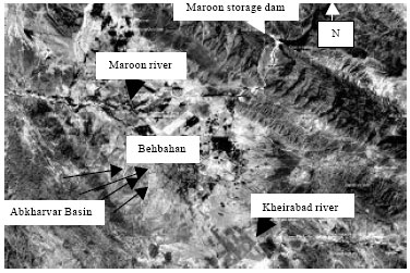 | |
| Fig. 1: | General location of Behbahan and the overlooking basin (Abkharvar) |
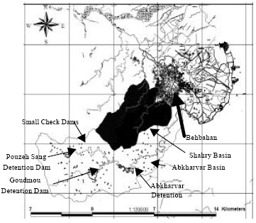 | |
| Fig. 2: | General layout of Abkharvar Basin, detention dams and check dams |
These constraints included location of the dams, keeping equality of area of neighboring subbasins and coincidence of artificial channels with the actual ones according to available maps and satellite images. Final subbasins delineation, title of each subbasin in model, derived channel network and the location of three detention dams were illustrated in Fig. 3. Required parameters, DEM-TIN and DEM-GRID models, slope maps, longest hydraulic flow path and main channel length and slope for each subbasin have been determined and developed. DEM-TIN of the study area showing location of detention ponds was shown in Fig. 4. Some of the important physiographical parameters derived for Abkharvar subbasins by GEO-HMS have been given in Table 1.
Storms recorded in DarehKaftarak weather station in vicinity of Behbahan city have been utilized to specify and determine extreme storms with different durations as well as their temporal patterns. Results were summarized in 6 and 24 h dimensionless curves.
SCS Runoff Curve Number (CN) and dimensionless unit hydrograph methods utilized to simulate hydrologic response of the basin. The Runoff Curve Number method is a procedure for hydrologic abstraction calculation, developed by the USDA Soil Conservation Service (named NRCS now).
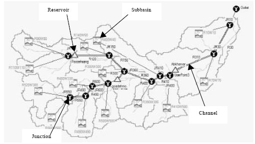 | |
| Fig. 3: | Illustration of HEC-HMS definition of subbasins and channel network |
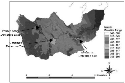 | |
| Fig. 4: | DEM-TIN of the study area with Detention Dams |
| Table 1: | Some of the important physiographical parameters derived by GeoHMS for Abkharvar subbasins |
 | |
In this method, runoff depth (i.e., effective rainfall depth) is a function of total rainfall depth and an abstraction parameter referred to as runoff curve number, curve number, or CN (Ponce, 1989).
SCS Curve Number (CN) and dimensionless unit hydrograph methods are integrated within HEC-HMS as infiltration and rainfall-runoff modules, respectively. These two modules are very popular because of their simplicity and acceptable accuracy. Bahadori Khosroshahi (1989) used SCS unit hydrograph in a watershed in Iran, named Jajrood. He compared this method with Snyder unit hydrograph and concluded that the latter gave better results in the study area. Kimiaee (1995) applied SCS method in Lighvan Basin in East Azarbayjan (Iran ) and showed that this method was very sensitive to high CNs.
 | |
| Fig. 5: | Hetograph and hydrograph of the historical event (6/12/2001) |
Sadeghi and Tadbiri (1995) used SCS method for flood discharge simulation in ungauged tributaries of AjiChai watershed (Iran), concluded that the simulated discharges for high return periods need to be corrected. Jandaghi et al. (2007) investigated on efficiency of Rational and SCS methods for estimating peak flood in a watershed in East Golestan (Iran) and concluded that these two models need to be calibrated before using as rainfall-runoff simulators. Shoshtari et al. (2003) used HEC-HMS for simulation of Kor and Sivand river flows in Fars province (Iran). They showed that after calibration, HEC-HMS worked efficiently in a Real Time Flood Forecasting system. Creek and Williams (2003) ran a research program in Berkeley University. In that research, Thompson Creek basin was simulated before and after urbanization. They used SCS curve number and unit hydrograph methods and concluded that HEC-HMS could be used for comparison of different scenarios even without calibration. Kathol et al. (2003) determined peak discharge and runoff volume for two agricultural basins in south east of South Dakota. They used SCS method for hydrologic abstraction and flood hydrograph simulation. This research showed sensitivity of the model to CN Values. Radmanesh et al. (2007) reported application of HEC-HMS, with SCS method, for flood forecasting in Roodzard basin, located in south west of Iran. Results showed a suitable coincidence of simulated and observed peak flows. Difference between simulated and actual time to peak was less than one hour for all of the events.
There are a few reports on using HEC-GeoHMS for hydrologic models data preparation. Shokoohi et al. (2007) reported using GeoHMS as a useful tool to prepare more sophisticated general plan in flood control projects in feasibility stage.
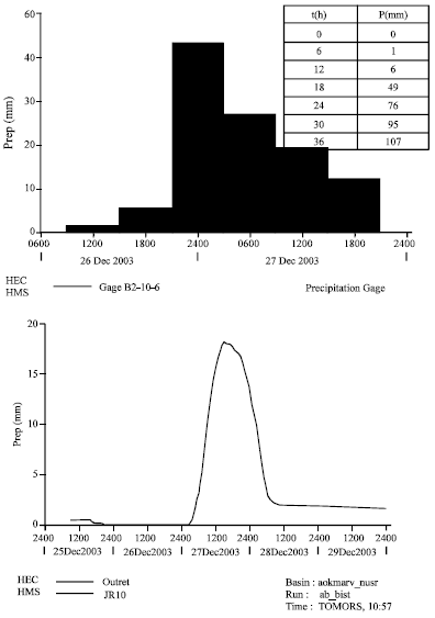
A flood dated 6/12/2001 was used to calibrate the model. Recorded hyetograph and flood hydrograph of this event and dimensionless cumulative rainfall of 24 h duration were shown in Fig. 5 and 6, respectively.
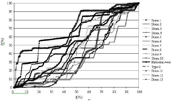 | |
| Fig. 6: | Dimensionless cumulative rainfall of some recorded 24 h duration rainfall in Behbahan |
It should be noted that at the time of this event the Abkharvar detention dam was not constructed and operational. Therefore, the HEC-HMS basin model was adapted for this specific circumstance.
Detention dams were simulated under two different conditions: 1) non-overflow dam and 2) overflow dam. In later condition, emergency spillway on dam crest was considered a broad-crested weir. To incorporate the small check dam effects, the option available in RUN tab of model package was checked. Considering the study objectives and supposing no limitation regarding material supply and neglecting transportation costs, city flood conveyance canal was designed both for with and without detention ponds alternatives. Other related costs, mainly land acquisition and bridge requirement costs, have been included in the analysis. Design flood for conveyance canal was a 50 year flood.
RESULTS
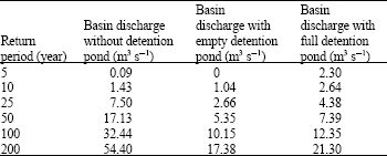
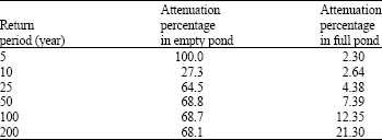
Results of flood estimation in Abkharvar basin under three different scenarios were presented in Table 2. The studied scenarios were: 1) without detention dam, 2) with empty detention dams and 3) with full detention dams. Effects of detention dams on flood peak attenuation were presented in Table 3.
Construction costs were estimated based on preliminary layouts of city master map, which have been developed for a pre-feasibility study. Therefore, the estimated costs were rough and they have been solely used in comparison of different alternatives. It should be noted that intention for construction of detention dams was not omitting downstream flood. Hence, cost estimation in detention pond system alternative includes, but not limited to, all cost items considered in alternative without detention ponds.
| Table 2: | Abkharvar basin flood estimation |
 | |
| Table 3: | Flood Peak Attenuation Percentage due to Detention Dam Effect |
 | |
Cost items mainly included canal construction, land acquisition and bridges and ponds constructions. Construction costs were 38 and 63 billion Iran Rials for with and without detention dam alternatives, respectively.
DISCUSSION
According to the results, using flood control measures in urban basins can be considered as a main alternative in urban flood control projects. The evident socio-economic benefits of the proposed flood control approach, confirms the contended tendency toward such measures in comparison with localized river engineering countermeasures. Also it approves the results achieved by some researchers and engineers, cited in the introduction section of the present study.
CONCLUSION
Results indicated that upon construction of detention ponds in urban basin considerable reduction in downstream flood flow and river engineering and flood control requirement magnitude and costs were achievable, while a higher safety factor was resulted in such areas (Table 1 and 2). As it was shown, incorporation of detention ponds in Behbahan urban basin resulted in about 40% reduction in flood control construction works. Flood, mainly low frequent ones, routed through detention ponds were attenuated by more than 60%. This outcome has positive mental impact, which must be recognized in conjunction to financial and economical benefits gained due to incorporation of such system. Special role of HEC-HMS mathematical model and ArcView GIS together with HEC-GeoHMS extension in development and analysis of different basin-wide flood control scenarios was emphasized. These softwares can provide tools for effective and quick analysis of hydrologic systems.
REFERENCES
- Dannil, E.I., G.D. Bouklis, P.L. Lazaridis and L.S. Lazaridis, 2000. Integrated approach for environmental flood protection for northern suburbs of athens, Greece. Proceedings of the ASCE joint Conference on Water Resources Engineering and Water Resources Planning and Management, 2000, Minneapolis, MN, USA., pp: 1-1.
- Jandaghi, N., P.S. Abad and M.M. Karahroudi 2007. An investigation on the efficiency of rational method and SCS artificial unit hydrograph for estimating of peak flood in East Golestan. Proceedings of the 7th International Conference on River Engineering, February 13-15, 2007, Chamran University, Ahwaz, Iran, pp: 1-7.
- Shoshtari, M.M., M. Majdzadeh Tabatabaee and A. Yousefi, 2003. Investigation and application of HEC-HMS model in river engineering; case study: Kor and Sivand river in Fars Province. Proceedings of the 6th International Conference on River Engineering, January 28-30, 2003, Chamran University, Ahwaz, Iran.