
Levi I. Nwankwo
Department of Physics, University of Ilorin, Ilorin 240003, Nigeria
Asian Journal of Earth Sciences
Year: 2011 | Volume: 4 | Issue: 1 | Page No.: 46-53


ABSTRACT
A 2D electrical resistivity survey has been carried out for water exploration at the MAGDAS Observatory, University of Ilorin. This is in view of the possibility that the observatory could gain international recognition and therefore the need to secure the area from acute water shortages for observers and researchers. The area lies within the basement rock terrain of West Central Nigeria and bounded by longitudes 4° 39’-4° 42’E and latitudes 8° 28’-8° 30’N. The survey was carried out using PELI 1300 portable terrameter while a total of 18 VES with 20 m station interval were completed in 3 even parallel profiles by means of Schlumberger configuration. The results revealed the presence of three geo-electric layer in the study area. The top lateritic soil has resistivity values ranging from 200 to 500 Ωm and thickness of 3 to 7 m. The weathered basement has resistivity values from 10 to 500 Ωm with thickness of 10 to 30 m while the fresh basement layer has resistivities greater than 900 Ωm. The analysis of resistivity and thickness maps reveal that the Western parts of the study area have relative low resistivities in the fractured weathered rocks coupled with thickness more than 25 m. This is consistent with aquiferous layer and therefore, such area maybe recommended as targets for groundwater tube drilling.
PDF Abstract XML References Citation
Received: May 04, 2010;
Accepted: July 12, 2010;
Published: November 05, 2010
How to cite this article
Levi I. Nwankwo, 2011. 2D Resistivity Survey for Groundwater Exploration in a Hard Rock Terrain: A Case Study of MAGDAS Observatory, UNILORIN, Nigeria. Asian Journal of Earth Sciences, 4: 46-53.
URL: https://scialert.net/abstract/?doi=ajes.2011.46.53
URL: https://scialert.net/abstract/?doi=ajes.2011.46.53
INTRODUCTION
In August 2006, Magnetic Data Acquisition System (MAGDAS) was installed in the University of Ilorin (UNILORIN) by experts from Space Environmental Research Centre (SERC) of Kyushu University, Japan under the auspices of the International Helio-physical Year (IHY) and Government of Japan (Maeda, 2008; Rabiu et al., 2009). Such MAGDAS system has been previously installed in Cote d’voire and Ethiopia. Subsequently, in 2008, some other units were installed across Africa (Maeda, 2008; Moodley et al., 2008). However, in March 2010, more magnetometers were installed in the UNILORIN observatory. During the installation, the team of Japanese Scientists from SERC remarked verbally that the MAGDAS facility in UNILORIN is believed to be to be one of the best functioning observatories in Africa and may probably become a centre of excellence in magnetic studies in Africa.
In view of the fact that there is a possibility of the observatory gaining international recognition, there is the need to adequately secure the area from acute water shortages for observers and researchers. Hence, a vision for an independent source of water for the observatory would be imperative. In line with this goal; a study of the groundwater condition at the observatory has been made. Groundwater is the water that lies beneath the ground surface, filling the pore space between grains in bodies of sediment and clastic sedimentary rock and filling cracks and crevices in all types of rock (Plummer et al., 1999). The source of groundwater is rain and snow that falls to the ground. A portion of this precipitation percolates down into the ground to become groundwater. How much precipitation soaks into the ground is influenced by climate, land slope, soil and rock type and vegetation. In general, approximately 15% of total precipitation ends up as groundwater, but that varies locally and regionally from 1 to 20%. Despite the fact that global water distribution shows that groundwater is about 0.61%, it is surprisingly, about 60 times as plentiful as fresh water in lakes and rivers on the surface (Plummer et al., 1999).
Studies have showed that groundwater could be explored using electrical resistivity methods (Olorunfemi and Fasoyi, 1993; Olasehinde, 1999; Alile et al., 2008). Previous work has been done within the University of Ilorin while utilizing electrical resistivity technique. Fracture pattern was elucidated using radial electrical resistivity sounding and profiling by Olasehinde et al. (1986) and at the same time they evaluated a prospective site for a weir on River Oyun using same electrical methods. Nwankwo et al. (2004) determined the structural disposition of the area using electrical resistivity pseudosection method while a combination of ground magnetic and electrical resistivity studies were used by Olasehinde (1999) to evaluate the groundwater potential of the Southern portion of the university with great success.
Where it is difficult to locate aquifers such as water-saturated zones in hard rock, it is also difficult to select suitable sites for water drilling. The 2D resistivity technique has improved the chance of drilling successes by identifying the fractured and weathered zones in these areas (Singh et al., 2006). Therefore, the use of such technique for groundwater exploration has earned an important place in recent years despite some interpretive limitations (Dogara et al., 1998; Singh et al., 2006). It is therefore expected that the results obtained from this work would produce detailed groundwater condition and recommend areas within the observatory were deep tube wells could be located. This would definitely meet the objective of securing the observatory from acute water shortages for both observers and researchers.
MATERIALS AND METHODS
Basic theoretical considerations: The fundamental equation for resistivity survey is derived from Ohm’s law (Grant and West, 1965; Dobrin and Savit, 1988):
| (1) |
where, ρ is resistivity, R is resistance, L is length of homogenous conducting cylinder and A is cross sectional area.
For the solid earth, whose material is predominantly made up of silicates and basically non-conductors, the presence of water in the pore spaces of the soil and in the rock fractures enhances the conductivity of the earth when an electrical current I is passed through it, thus making the rock a semi-conductor. Since the earth is not like a straight wire and it is anisotropic, then Eq. 1 is thus customized to:
| (2) |
where, ΔV is change in voltage and r is the radius of current electrode’s small hemisphere.
Since, the earth is not homogeneous, Eq. 2 is used to define an apparent resistivity ρa which is the resistivity the earth would have if it were homogeneous (Grant and West, 1965):
| (3) |
where, 2πr is then defined as a geometrical factor (G) fixed for a given electrode configuration.
The Schlumberger configuration was used in this study. The geometric factor G is thus given as:
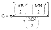 | (4) |
where, AB is current electrode spacing and MN is spacing between potential electrodes.
Location and geological setting: The area of study lies entirely within the basement rocks in the Western part of Central Nigeria bounded by longitudes 4° 39’-4° 42’E and latitudes 8° 28’-8° 30’N (Fig. 1). This area falls within the Eastern part of Ilorin, a semi-arid region of Nigeria with vegetation mainly of the guinea savannah type with shrubs and undergrowth. Rugged troughs and crests due to erosions characterize the topography of the area.
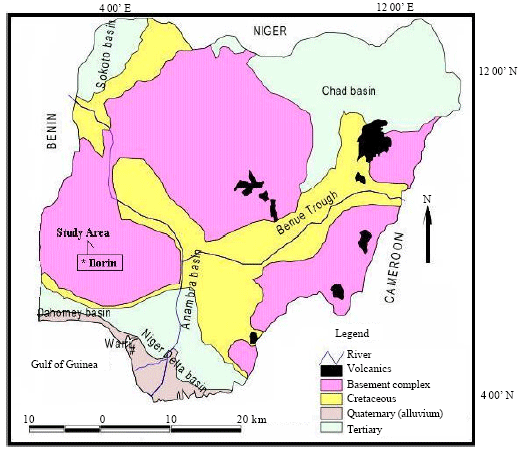 | |
| Fig. 1: | Geological map of Nigeria showing the surveyed area |
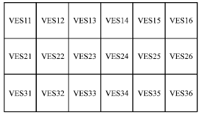 | |
| Fig. 2: | Survey layout at 20 m VES station interval |
The area is drained by rivers and streams such as Oyun river and river Ile-apa as a tributary of River Niger (Nwankwo et al., 2004).
The rocks are mainly banded gneiss, sheared gneiss and augen gneiss intruded by granodiorites and granites at the Southeast. The structural fabric is mainly a North-South trending fracture system dominated by a Southerly plunging (6°-10°) anticlinorium with a gentle Westerly dipping limb is depicted (Olasehinde, 1999; Olasehinde et al., 1986). The rocks within the basement complex of South-West Nigeria has been classified into five major groups: Migmatite-Gneiss complex which comprises gneisses, quartzite, calc silicates rocks, biotite hornblende schist and amphibolites; slightly migmatised to unmigmatised para-schists and meta-igneous rocks; Charnockitic rocks; Older granites; and Unmetamorphosed dolerite dykes, which comprises pegmatite, quartz veins and doleritic dykes (Rahaman, 1973).
Field survey: A four day ground resistivity survey was carried out at MAGDAS Observatory, University of Ilorin in February 2009 using PELI 1300, a low frequency potable terrameter. A total of 18 Vertical Electrical Soundings (VES) with 20 m station interval was completed in 3 even parallel profiles for two dimensional (2D) groundwater investigations (Fig. 2).
The depth to the basement rock in the study area was not expected to be too deep (Nwankwo et al., 2004); however, for proper depth probing a total current electrode spread of 200 m was used with the Schlumberger configuration.
RESULTS AND DISCUSSION
The apparent resistivities of the VES stations plotted on a log-log graph against corresponding half Schlumberger were interpreted by computer iteration technique. The curves, which are predominantly A-type (1<ρ2<ρ3) and H-type (ρ1>ρ2<ρ3), are shown in Fig. 3. The resistivity values of some common water bearing rocks are 1-100 (Ωm), 10-800 (Ωm) and 10-100 (Ωm) for clay, alluvium and fresh groundwater respectively. These resistivity values and that of some other common rocks are presented in Table 1.
In order to consider the hydro-electrical characteristics of the study area, the results were then used to develop series of 2D resistivity pseudo-sections (Fig. 4) at various depths and 2D thickness section (Fig. 5) of the aquiferous zone as determined from the interpretation of results. These maps are profiles of resistivity and thickness contrasts of rock layers within a depth extent in the survey area.
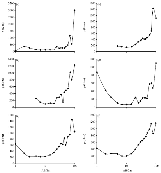 | |
| Fig. 3: | Resistivity plots of some VES stations. (a) VES11, (b) VES22, (c) VES24, (d) VES25, (e) VES32 and (f) VES36 |
| Table 1: | Resistivity of some common rocks (after Singh et al., 2006) |
 | |
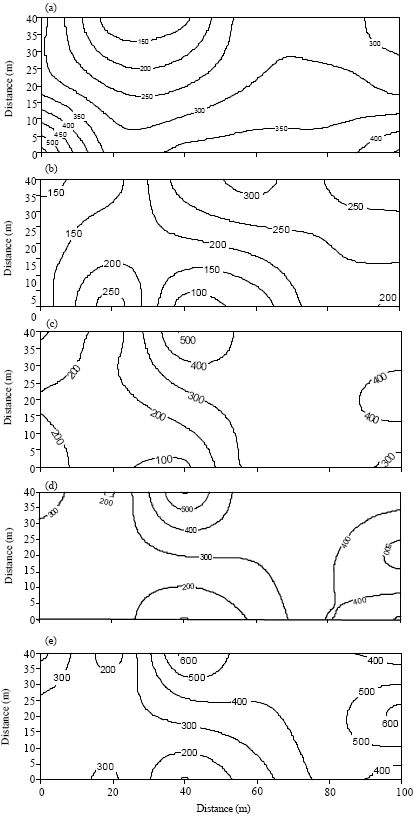 | |
| Fig. 4: | 2D resistivity contour map of the first/second layers. (a) Resistivity contour map of the surface Layer. Contour interval = 50 m, (b) 2D resistivity contour map of the study area at AB/2=15 m. Contour interval = 50 m, (c) 2D resistivity contour map of the study area at AB/2=25 m. Contour interval = 100 m, (d) 2D resistivity contour map of the study area at AB/2=30m. Contour interval = 100 m, (e) 2D resistivity contour map of the study area at AB/2=35m. Contour interval = 100 m |
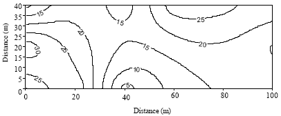 | |
| Fig. 5: | 2D Contour map of the second layer thickness |
The purpose of selecting multiple layers was to distinguish the different lithological units and to convert the resistivity values into a geological reasonable picture. The analysis of the field data shows that study area is embedded with three geoelectrical layers. The resistivity of the first layer varies from 200 to 500 Ωm, interpreted as top lateritic soils. The resistivity of the second layer ranges from 10 to 500 Ωm, which was interpreted as weathered rock containing water. This layer also have water-saturated weathered zone. Lower resistivity values in the area are either due to silty or clayey soils. The third layer resistivity has values above 900, interpreted as fresh basement rocks. Although, there is limited published geophysical work for the study area, these results are consistent with available findings for the university area (Olasehinde et al., 1986; Olasehinde, 1999; Nwankwo et al., 2004). They had earlier revealed that the structural characteristics of the area are made up of three geo-electrical layers.
Based on the model classification in this study, the distribution of resistivities in the surface layer is not uniform. Figure 4a shows that the resistivity values of the surface layer ranges from 200 to 500 Ωm. The figure indicates that the apparent resistivity values are increasingly spreading from the North-West area to other parts in the study area. The texture of the rock in this layer was found to be generally hard and dry due to high exposure to intense heat from the sun.
Figure 4b-e were prepared to see how the resistivity values of the weathered basement and aquiferous zone varies from place to place at different depths with the aim of delineating the most favourable area and depth for groundwater exploitation as well as delineating possible structures or structural trends, if any, within the layer of the weathered basement. The resistivity variations at 15 m depth (Fig. 4b) shows that very low resistivity values (<100 Ωm) are found around the South central portion of the study area and resistivity values not more than 150 Ωm are also dominated in NW-SW region. At 25 m depth, Fig. 4c shows that the variations of the resistivity within these two regions (that is, South Central and NW-SW) are constant. However, at 35 m depth, Fig. 4d reveals that there is a diminutive increase in the resistivity values of both portions but these fall below 300 Ωm. Figure 4b-e has reveal that there exist some consistencies of low resistivities at these two areas right from 15-35 m depth. These areas suggests plausible targets for groundwater exploitation, however to make reasonable judgement the thickness variations of the aquifer in these areas are to be considered (Dogara et al., 1998).
Therefore, Fig. 5 depicts the second layer thickness variations as well as the aquiferous zone of the study area. As can be deduced from the map, the thickness of the weathered basement has a maximum of 30 m. Considering the two inferred plausible areas for groundwater target, it has been discovered that the South central area has thickness less than 10 m while a thickness of 30 m exist within the NW-SW axes. Studies have shown that aquifer thickness is of utmost important (Dogara et al., 1998), the larger the thickness, the larger amount of water the place can hold and vice-versa. Consequently, the most favourable target for siting groundwater tube in the study area would be NW-SW, particularly, the central part of the area.
ACKNOWLEDGMENT
Author thanks Bayo Geophysical Services, Sango Ilorin for releasing the PELI 1300 Terrameter used in this study.
REFERENCES
- Alile, M.O., S.I. Jegede and O.M. Ehigiator, 2008. Underground water exploration using electrical resistivity method in Edo State, Nigeria. Asian J. Earth Sci., 1: 38-42.
CrossRefDirect Link - Olorunfemi, M.O. and S.A. Fasuyi, 1993. Aquifer types and the geoelectric/hydrogeologic characteristics of part of the central basement terrain of Nigeria (Niger state). J. Afr. Earth Sci. (Middle East), 16: 309-317.
CrossRefDirect Link - Rabiu, A.B, I. A. Adimula, K. Yumoto, J. O. Adeniyi and G. Maeda, 2009. Preliminary results from the magnetic field measurements using MAGDAS at Ilorin, Nigeria. Earth Moon Planets, 104: 173-179.
CrossRef - Singh, K.K.K., A.K.S. Singh, K.B. Singh and A. Sinha, 2006. 2D resistivity imaging survey for siting water-supply tube wells in metamorphic terrains: A case study of CMRI campus, Dhanbad, India. The Leading Edge, 25: 1458-1460.
CrossRefDirect Link
N.P.Dharmadhikari Reply
is there any material on topic" characterization of soil when expoed to geopathic stress zone"
Mendis B.M.S.W Reply
please send me specific hand books which are Ground Water exploration using geo electrical resistivity surveys