
H. Akther
Department of Geography and Environment,University of Dhaka, Dhaka 1000, Bangladesh
M.S. Ahmed
Aquatic Resource Management Laboratory, Department of Zoology, University of Dhaka, Dhaka 1000, Bangladesh
K.B.S. Rasheed
Department of Geography and Environment,University of Dhaka, Dhaka 1000, Bangladesh
Asian Journal of Earth Sciences
Year: 2009 | Volume: 2 | Issue: 2 | Page No.: 49-57


ABSTRACT
This study was conducted to determine the present status of groundwater level in Dhaka city. During 2005, about 1.6 Mm3 day-1 of groundwater was withdrawn by Dhaka Water Supply and Sewerage Authority (DWASA) against the city’s total demand of 2.1 Mm3 day-1. Compared to the exploitation of groundwater, the recharge to aquifer is very negligible as the geological settings and urbanization has retarded both the vertical and horizontal recharges. Consequently, groundwater table is continuously declining at an average rate of 2 m year-1 since, 1986. Continuous groundwater mining has caused the dry season water table to move downward from -54 to -45 m depth from the sea level. The severe decline of groundwater level was observed in the central part of the city, compare to the river periphery, creating a cone of depression. If this falling trend of the groundwater level continues that might create an increased pressure on water storage and may invite land subsidence or other environmental hazards. So, the aquifer requires sustainable management to protect future water quality and to ensure that the resource can continue to meet the quantitative demands being placed upon it.
PDF Abstract XML References Citation
How to cite this article
H. Akther, M.S. Ahmed and K.B.S. Rasheed, 2009. Spatial and Temporal Analysis of Groundwater Level Fluctuation in Dhaka City, Bangladesh. Asian Journal of Earth Sciences, 2: 49-57.
URL: https://scialert.net/abstract/?doi=ajes.2009.49.57
URL: https://scialert.net/abstract/?doi=ajes.2009.49.57
INTRODUCTION
Groundwater plays a very significant role in the supply of water for human activities. In most parts of the developing world, rapid expansion in groundwater exploitation occurred between 1970 and 1990 (UN/WWAP, 2003; Villholth, 2006). As a part of developing world, Dhaka, the capital of Bangladesh, has experienced large scale abstraction of groundwater to meet up the water supply needs with its rapid growing population (Khan and Siddique, 2000). Dhaka historically reported as a city of migrants (Islam, 1996) and over growing population zone, had a 1985 population of 4.9 million (UNEP, 1992) which grew to 7.8 million by 1995 (UNPD, 1995) and had achieved a mega city status of over 10 million population by 2001. It is now one of the world’s 25 largest cities.
Dhaka is more than 80% dependent on groundwater for domestic, industrial and commercial water supply. The rise in groundwater use over the last 50 years continues apace, from the drilling of the first borehole in 1949 to more than 400 public-supply boreholes abstracting an estimated 1.6 Mm3 year-1 against the city’s demand of 2.1 Mm3 day-1 (DWASA, 2005). New investment in the late 1990's has significantly increased the number of public-supply boreholes operated by the utility, DWASA. Abstraction from private boreholes, whose numbers have also expanded dramatically to more than 1000 (DWASA, 2005), is unquantified but likely to be substantial.
Generally, groundwater table in an area rises due to increase in groundwater storage from sources such as infiltration of rainfall, recharge due to stream seepage, canal irrigation, seepage surface flow, etc. In this perspective, it seems that Dhaka City is rich in groundwater as the city is located adjacent to distributaries of the gigantic Ganges-Brahmaputra-Meghna River system, ensures that induced recharge is possible through the Buriganga River bed (Darling et al., 2002). In fact, the situation is different. The subsurface geology of Dhaka City shows that upper formation is Madhupur clay layer and termed as aquitard and it is 6 to 12 m thick in most parts of the city. This thick clay layer retards vertical recharge of rain water infiltration and horizontal recharge through seepage of streams (Hasan et al., 1999; Ahmed et al., 1999; Morris et al., 2003; Hoque et al., 2007). The Madhupur clay mainly consists of kaolinite (26.79-53.33%) and illite (13.73-33.04%) with very small amount of illite smectite (2.11-12.94%) down to 5 m depth (Zahid et al., 2004). The higher co-efficient of permeability is related to higher amount of illite-smectite mixed layer clay minerals. The vertical permeability of this clay varies from 6.5x10⁻⁴ to 1.5x10² m day-1 that can neither yield to wells nor transmit appreciable water to the aquifer below. However, below the clay layer, medium to coarse grained formation exist. All groundwater has withdrawn from this aquifer to meet the total water demand of the city dwellers.
At present, DWASA is operating 421 deep tube wells and four water treatment plants on the bank of surrounding Rivers. The contribution of four treatment plants in total water supply is only 18% and the rest of water supply comes from exploitation of groundwater. The existing facilities of DWASA cannot keep pace with growing demand of safety water supply. Both quantities, and distribution facilities are inadequate to serve the inhabitants of the city. So, the city dwellers had already been experienced a scarcity of safety water (Akther and Billah, 2005). The magnitude of the problem becomes severe during the extreme dry and hot season. The reason is that the production of the tube wells decreases and conversely the demand increases. As a result, uncontrolled abstraction of groundwater led to over-exploitation of the resources. In contrast, the rechargeable areas are being reduced gradually due to expansion of infrastructures. So, natural water recharge to aquifer cannot keep pace with the water withdrawal since two decades, causing declination of water table which needs closer examination.
This study described the status and trends of groundwater level fluctuation in Dhaka City from 1986 to 2005.
MATERIALS AND METHODS
Study Area
The study was conducted from January 2003 to December 2005 in Dhaka City which is a Metropolis as well as the capital city of Bangladesh, lies between latitude 23°40´ N to 23°54´ N and longitudes from 90°20´ E to 90°30´ E and covers an area of about 470 km2 having the altitude of 6.5 to 9 m above mean sea level (Fig. 1). Geologically, it is an integral part in the southern tip of the Madhupur Tract, an uplifted block in the Bengal basin, with many depressions of recent origin in it. It is bounded by the Tongi khal in the North, the Buriganga river in the South and Southeast, the Balu River in the East and the Turag River in the West.
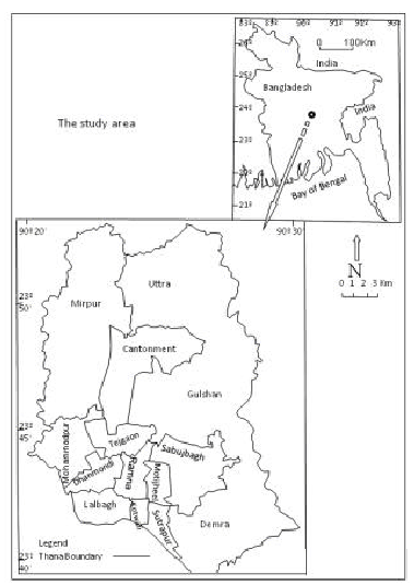 | |
| Fig. 1: | The study area, the Metropolitan Dhaka City |
The area is characterized by a tropical monsoon climate with an average annual precipitation of 2500 mm (from 1986 to 2005). The rainfall was unevenly distributed throughout the year, maximum during July and August. The annual mean temperature is 26°C with long-term average maximum and minimum monthly temperatures at Dhaka ranges from 25.5 and 11.7°C in January to 35.1 and 23.4°C in April. The evaporation over the area is fairly high. Dhaka is zoned for water supply purposes into six districts with newer zones having the higher numbers.
Data Collection and Analysis
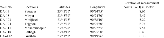
The groundwater data from January 1986 to December 2005 was procured from the groundwater circle II (GWC II) a wing of Bangladesh Water Development Board (BWDB). GWC II in Dhaka City has been maintaining and keeping records of groundwater observation wells since 1963. The records are published annually in the BWDB water supply papers. The dug/piezometric surface wells give weekly records whereas the auto recording wells give daily records. The data from dug well in fact reflect the water table but not the piezometric surface. At present there are eleven observation wells nine piezometric and two auto- recording wells in the Dhaka city. The observation wells from which the data were collected are shown in Table 1.
| Table 1: | The number and location of observation wells |
 | |
Groundwater abstraction, supply and demand data were collected from DWASA. Other relevant data were procured from varies government and semi-government organizations.
Bangladesh water development board supplied weekly groundwater level data for corresponding measuring point of different observation wells. This data was converted into monthly average groundwater level of each observation wells and monthly data of each year from 1986 to 2005 of each observation well were calculated. Groundwater table with respect to PWD (Public Works Department) sea level was calculated as deducting the groundwater level below measuring point from the elevation of measuring point in m (PWD) (BWDB, 1991). The negative value indicates water level below sea level.
RESULTS AND DISCUSSION
Trend of Groundwater Level Fluctuation
The groundwater demand and supply scenario in Dhaka City from 1963 to 2005 has directed towards the over exploitation of the resources (Fig. 2). Fluctuation of groundwater level was different in magnitude for different location depending on the abstraction and recharge. All the available data of seven observation wells from the year of 1986 to 2005 used to prepare groundwater level hydrographs of Dhaka City (Fig. 3). It was observed that all the hydrographs had a lowering tendency of both highest and lowest table. In some areas, the variation was steep viz., well No. DA-123 (Motijheel), DA-111 (Mohammadpur), DA-A12 (Gulshan) and DA-15 (Mirpur). In other areas, the variation was smooth viz., DA-110 (Lalbagh) and others had neither smooth nor steep rather an irregular feature of declining (DA-13 Sutrapur, DA-13 Tejgaon). The hydrographs shows that the level rises to its peaks in late wet season when groundwater replenishes with water. During October, November and December, groundwater level starts depleting rapidly and reached at the peak of decline in late dry season (Fig. 3).
Spatial and Temporal Variation of Groundwater Level
There are eleven observation wells inside Dhaka City. Depth of groundwater level of whole Dhaka City cannot be possible to determine on the bases of that observation wells. So, some additional observation wells around Dhaka city were considered to determine the groundwater level in the peripheries of Dhaka City. The distributions of groundwater level of the years 1986, 1990, 1996 and 2005 at late dry season have shown in Fig. 4, to show the maximum decline of water level.
Groundwater level is comparatively high in periphery and low in the central portion of the city. Among the periphery, the Northern portion of the city has comparatively higher water level than Southern portion of the city. Because Northern portion have large open space, many small surface water bodies dispersed there and moreover, the low rate of withdrawal of groundwater.
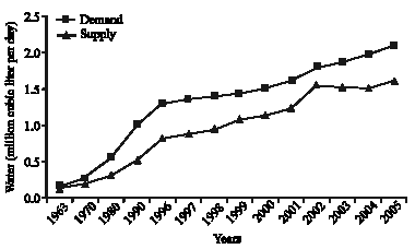 | |
| Fig. 2: | Groundwater demand and supply in Dhaka City from 1963 to 2005 |
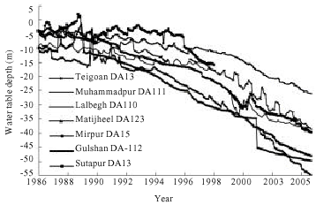 | |
| Fig. 3: | Groundwater hydrograph of seven observation wells of Dhaka city from 1986 to 2005 |
In the Southern periphery of the city groundwater is largely developed in the early period of the development of the city. This densely populated area has higher rate of water abstraction than Northern periphery of the city. In 1996, the water level of Southern periphery and northern periphery in two season viz., late dry and wet season were -6, -9 and -4 -7 m, respectively and that had declined to -40, -39 and -26, -24 m, respectively at the end of 2005 (Fig. 4).
In the central portion of the city viz., Ramna, Motijheel, Tejgoan, have high withdrawal of groundwater with minimum scope of recharge. So, there is a cone shape depression of groundwater in central city with 0.5, 2 m km-1 gradient from Northern periphery and Southern periphery to the central portion, respectively (Fig. 4). The groundwater level in the central portion of city was -53, -21 and -11 m in late dry season in the year of 2005, 1996 and 1986, respectively (Fig. 4). In 1986, there were two center of depression of groundwater level one was around well No. DA-103 (Cantonment) and another was well No. DA-123 (Motijheel) in the central portion of Dhaka (Fig. 4). In 1996, the pattern of such water level was merged within one center of depression in central part of Dhaka due to the expansion of urbanization around the cantonment the groundwater is largely affected by pumping system of DWASA and water level fall which in turn continue to that depression line. During the year of 2005, the groundwater level contour lines were again changed their pattern with two center of high depression one was around well no DA-15 (Mirpure) and another was around the well No. DA-123 (Motijheel) and one center of low depression around the observation well No. DA-111(Mohammadpure) (Fig. 4).
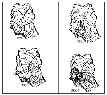 | |
| Fig. 4: | Groundwater contour maps of Dhaka City during late dry season (Mid-May) in 1986, 1990, 1996 and 2005 |
After 1996, Mirpure gradually turned into an important residential area for middle class people of Dhaka City and results high abstraction of water to meet the demand of population. The average decline of groundwater from 1986 to 1990, 1990 to 1996 and 1997 to 2005 was 0.53, 1.24 and 2.5 m, respectively.
From the last 20 years data of groundwater level fluctuation, it reveals that the groundwater level of Dhaka City is continuously declining. Groundwater level fluctuation patterns had abruptly changed and steeply declined after 1990 (Fig. 3). The pattern of groundwater level fluctuation is straight not up and down like a standard hydrograph after 1990 (Hasan et al., 1999; Zahid et al., 2004; Hoque et al., 2007). In earlier studies level fluctuation were shown in yearly average monthly and seasonal groundwater level depleting were also observed in the present study.
The results reinforced that despite the city’s location in a zone of ample annual effective precipitation and its proximity to a major hydraulically connected river system, the aquifer providing 82% of the city’s water supply needs is experiencing major declines in water levels. The principal explanation for the trend of falling levels despite apparentlyample sources of recharge at the surface is likely to be a result of three reasons. Firstly, the Dupi Tila aquifer is confined by the leaky Madhupur formation of silty clays, which is patchy but on average about 10 m thick beneath Dhaka. As seasonal water levels have fallen from a few meters below ground level in the 1980's to -54 m in the year 2005, the aquitard has been drained and the upper part of the Dupi Tila is now being dewatered. Secondly, once saturated conditions give way to unsaturated, the vertical hydraulic conductivity is reduced, especially in the uppermost finer-grained strata where narrow pore necks become filled with air and obstruct water passage. Although, the Dupi Tila is in places sufficiently dewatered to have become unconfined, changes from the initial leaky confined response of wells to pumping also reflect the reduced amount of recharge to the aquifer as the hydraulic resistance increases. In effect, the drawdown-limiting tendency for free drainage from the aquifer under unconfined conditions is counterbalanced by a reduced capacity for leakage through the aquitard. In the case of the Dhaka aquifer, drawdowns have increased and therefore specific capacities have decreased. Thirdly, when a well begins to pump water from an aquifer, the water is withdrawn from storage around the well and from vertical leakage. In the Dupi Tila aquifer of Dhaka city, withdrawals of water through hundred of wells has developed the cone of depression, resulting a complex surface of water table condition which also increases the length of flow path in turn slow recharge (Morris et al., 2003).
Falling water levels have adversely affected the productivity of new city public-supply wells, which during the boom in well drilling of the 1990's have shown a specific capacity almost 30% lower than their equivalents from the 1970's (Hoque and Shahabuddin, 1998; Morris et al., 2003). Recharge mechanisms to an urban/urbanising aquifer are complex, but one global conclusion emerging from the relatively few studies carried out to date on groundwater-dependent cities is that irrespective of climatic regime, the quantity of recharge tends to increase, reflecting the rise in potential sources of water that can infiltrate from the city water and drainage infrastructure (Eiswirth et al., 2004; Krothe et al., 2002). Even if recharge is increasing (no records) it does not appear to be keeping pace with rising abstraction, so water levels are falling as withdrawals from storage occur.
If the present rfate of abstraction, extended urbanization and silting of river beds continues, lateral inflow of water to groundwater aquifer will be reduced which will be aggravated in groundwater mining, too (Hoque et al., 2007). Because of groundwater lowering trend, re-sinking and re-fixing of many existing tube well will be required at greater depth and thereby will be increased installation and pumping cost. Moreover, electricity consumption will be higher to lift water from greater depth. If groundwater is continuously withdrawn, the ground surface may subside because the water no longer supports the sediment (Plummer et al., 2004). As such, land-subsidence has experienced with over exploitation of groundwater by Mexico City, California’s Central Valley, Jakarta, Suzhou city of China and many other cities of the world (Poland and Davis, 1969; Abidin et al., 2001; Chongxi et al., 2003). Such land-subsidence can crack building foundation, roads and pipelines. Over pumping of groundwater also causes compaction and porosity loss and can permanently ruin good aquifers.
CONCLUSION
The existence of the thick and productive Dupi Tila aquifer beneath Dhaka has been of immeasurable benefit to a city with limited financial resources. Groundwater drawn locally from this aquifer continues to be the prime source to meet demands for domestic, industrial and commercial water supplies provided either by the public utility or by private well owners. As a resource supplying of Mega city the aquifer requires sustainable management not only to protect future water quality but also to ensure that the resource can continue to meet the quantitative demands being placed upon it. Accordingly, some immediate measures, such as surface water treatment plants need to be set up by DWASA to reduce dependence on ground water. As an alternate measure a well field or surface water reservoir may be constructed in the adjoining areas to augment groundwater. If possible, some artificial recharge like injector wells may be set up to supplement the natural infiltration. Some permanent bench mark observatory station like surface settlement plates and compression indicator at different depths may be set up immediately by DWASA to monitor any evidence of land subsidence.
ACKNOWLEDGMENTS
The authors thank to Dhaka Water Supply and Sewerage Authority (DWASA) and Bangladesh Water Development Board (BWDB), Groundwater Circle II, for providing the information that forms the principal data source for this study.
REFERENCES
- Abidin, H.Z., R. Djaja, D.D. Darmawan, S. Hadi and A. Akbar et al., 2001. Land subsidence of Jakarta (Indonesia) and its geodetic monitoring system. Nat. Hazards, 23: 365-387.
CrossRefDirect Link - Ahmed, K.H., M.K. Hasan, W.G. Burgess, J. Dottridge, P. Ravenscroft and J.J. Van Wonderen, 1999. The Dupi Tila Aquifer of Dhaka, Bangladesh: Hydraulic and Hydrochemical Response to Intensive Exploitation. In: Groundwater in the Urban Environment: Selected City Profiles, Chilton, P.J. (Ed.). A.A. Balkema, Rotterdam, pp: 19-30.
- Chongxi, C., P. Shunping and J.J. Jiao, 2003. Land subsidence caused by groundwater exploitation in Suzhou City, China. Hydrogeol. J., 11: 275-287.
CrossRef - Eiswirth, M., L. Wolf and H. Hotz, 2004. Balancing the contaminant input into urban water resources. Environ. Geol., 46: 246-256.
CrossRefDirect Link - Khan, H.R. and Q.I. Siddique, 2000. Urban water management problems in developing countries with particular reference to Bangladesh. Int. J. Water Resour. Dev., 16: 21-33.
CrossRef - Hoque, M. A., M.M. Hoque and K.M. Ahmed, 2007. Declining groundwater level and aquifer dewatering in Dhaka Metropolitan area, Bangladesh: Causes and quantification. Hydrogeol. J., 15: 1523-1534.
CrossRefDirect Link - Morris, B.L., A.A. Seddique and K.M. Ahmed, 2003. Response of Dupi Tila aquifer to intensive pumping in Dhaka, Bangladesh. Hydrogeol. J., 11: 496-503.
CrossRefDirect Link - Villholth, K.G., 2006. Groundwater assessment and management: Implications and opportunities of globalization. Hydrogeol. J., 14: 330-339.
CrossRefDirect Link